| GISdevelopment.net ---> AARS ---> ACRS 2000 ---> Global Change |
Satellite Observation Of
Migration Routes And Habitats Of Migratory Birds Living In Wetlands In
East Asia
Masayuki
TAMURA
Social and Environmental Systems Division
National Institute for Environmental Studies
Japan Environmental Agency
16-2 Onogawa, Tsukuba, Ibaraki, 305-0053 Japan
Tel: (81)298-50-2479, Fax: (81)298-50-2572
E-mail:m-tamura@nies.go.jp
Hiroyoshi HIGUCHI
Laboratory of Biodiversity Science
School of Agriculture and Life Sciences
University of Tokyo
1-1-1 Yayoi, Bunkyo-ku, Tokyo, 113-8657 Japan
Tel: (81)3-5841-7541, FAX: (81)3-5841-8192
E-mail:higuchi@uf.a.u-tokyo.ac.jp
Key Words: Argos system, red-crowned crane, oriental white stork, remote sensing, Landsat/TM
Abstract:
Migration routes and habitats of red-crowned cranes and oriental white storks were studied by two kinds of satellite-based observation techniques, i.e. satellite tracking and remote sensing techniques. By the former we obtained bird location data; by the latter we investigated habitat ecosystem conditions. By combining these two techniques we analyzed the relationship between ground conditions and habitation patterns of wetland migratory birds. In the summer of 1999 small platform transmitter terminals were set on six red-crowned cranes and six oriental white storks in the wetlands along the Amur River in the Russian Far East. Their migration routes to wintering sites in China were tracked by using the satellite tracking technique. Locations of important places for breeding, stopover and wintering have been extracted from the migration data. Satellite remote sensing technique was used for investigating ground environmental conditions. The relationship between wetland ecosystems and habitation patterns of migratory birds was investigated.
1. Introduction
Recently wetlands are being recognized as important ecosystems for the conservation of biodiversity. They support wide variety of flora and fauna and serve as habitats for many kinds of creatures including migratory birds. However wetlands are disappearing at a rapid rate in East Asia due to human activities such as agricultural, residential, and industrial developments (Hussain, 1994). The decrease and environmental deterioration of wetlands are bringing quite a few species of migratory birds to face the danger of extinction. For the conservation of wetland ecosystems and wetland migratory birds, it is urgently needed to understand the actual situation of the decrease and environmental destruction of wetlands and to investigate the relationship between wetland ecosystems and habitation patterns of migratory birds.
In this study a satellite tracking system (Argos system, http://www.argosinc.com/) was used to pursue migration routes of two species of migratory birds, i.e. red-crowned cranes and oriental white storks, both of which are in danger of extinction. They can serve as good indicators of the conservation state of wetlands because they stand at the top of the wetland food chains. The satellite tracking data were used to extract locations of important places for breeding, stopover and wintering. We then used satellite images (NOAA/AVHRR and Landsat/TM images) for investigating the distribution and environmental conditions of the wetlands in East Asia. The relationship between wetland ecosystems and habitation patterns of migratory birds was analyzed by combining remotely sensed images and satellite tracking data of bird locations.
2. Satellite Tracking Of Migration Routes
In the summer of 1999 small platform transmitter terminals (PTT) were set on six red-crowned cranes and six oriental white storks in the wetland areas along the Amur River in the Russian Far East. Figure 1 shows the capture points. Their migration routes from the breeding sites in the Amur Basin to the wintering sites in China were tracked by the Argos system. The accuracy of the Argos system is indicated by the location class (Table 1). Basically we only used the data with the location classes higher than 1, which means the error of an estimated bird location is less than 1 km.
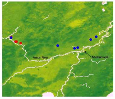
Fig. 1. Capture points. (Red: red-crowned cranes, Blue: oriental white storks).
Table 1 Accuracy of the Argos system
(http://www.argosinc.com/).
| Location Class | Estimated accuracy in latitude and longitude |
| 3 | <150m |
| 2 | 150m<accuracy<350m |
| 1 | 350m<accuracy<1000m |
| 0 | >1000m |
| A | no estimate of location accuracy |
| B | no estimate of location accuracy |
| C | (invalid locations) |
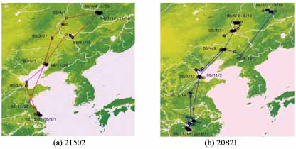
Fig. 2. Migration routes of a red-crowned crane 21502 and an oriental white stork 20821.
Table 2 (a) Migration data in autumn 1999.
| ID | Species | Departure | Arrival | Days | Destination |
| 20819 | Red-crowned crane | 99/11/11 | 99/11/17 | 6 | Yancheng marsh |
| 21502 | Red-crowned crane | 99/11/10 | 99/12/02 | 22 | Yancheng marsh |
| 20820 | Oriental white stork | - | 99/12/07 | - | Poyang lake |
| 20821 | Oriental white stork | 99/09/19 | 99/11/18 | 70 | Poyang lake |
| 20823 | Oriental white stork | 99/08/21 | 99/12/10 | 111 | Poyang lake
|
Table 2 (b) Migration data in spring 2000.
| ID | Species | Departure | Arrival | Days | Destination |
| 21502 | Red-crowned crane | 00/03/01 | 00/04/04 | 34 | Arkhara lowland |
| 20821 | Oriental white stork | 00/03/17 | 00/05/02 | 47 | Zhalong marsh
|
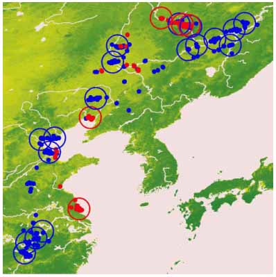
Fig. 3. Important habitats. (Red: red-crowned crane, Blue: oriental white stork ).
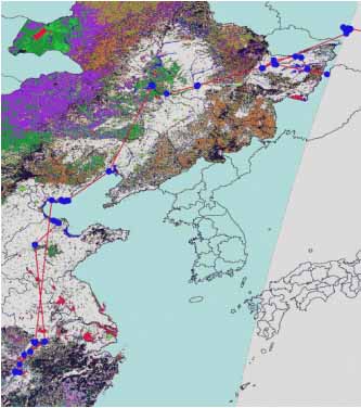
Fig. 4. Land cover map of China with a migration route of an oriental white stork 20823.
3. Analysis Of Habitat Conditions Using Satellite Imagery
To investigate the ground conditions of bird habitats we used satellite images. Figure 4 shows a part of a Chinese land cover map produced from NOAA/AVHRR and Landsat/TM images by Luo Di of the Institute of Remote Sensing Applications, Chinese Academy of Science. We overlaid bird locations on this map and studied in what kinds of land cover types the birds liked to stay. In Figure 4 the migration route of an oriental white stork (ID: 20823) is indicated as an example. Figure 5 shows the number of location data obtained at each of six land-cover types for two red-crowned cranes and three oriental white storks. We note that four out of five birds were found more frequently in farmlands than in wetlands. This frequent use of farmlands may be causing some friction with human activities in China. We also note that red-crowned cranes were found more frequently in grasslands than oriental white storks. This may be explained by the fact that the former is omnivorous while the latter is carnivorous.
To obtain detailed information on the wetland ecosystems we used Landsat/TM images. Figure 6 shows the result of land-cover classification using a TM image (path:116, row:26) in Arkhara Lowland, which lies along the Amur River around the Arkhara River confluence in the
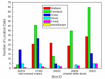
Fig. 5. Bird locations in China.
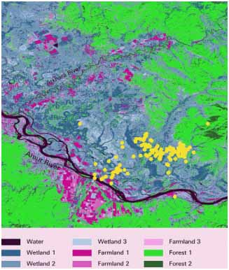
Fig. 6. Land-cover map of Arkhara Loeland in the Russian Far East.
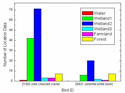
Fig. 7 Bird locations in Arkhara Lowland in the Russian Far East.
4. Conclusions
Migration routes and habitats of red-crowned cranes and oriental white storks were studied by two kinds of satellite observation techniques, i.e. satellite tracking and remote sensing techniques. By the former we obtained bird location data; by the latter we investigated habitat ecosystem conditions. By combining these two techniques we analyzed the relationship between ground conditions and habitation patterns of wetland migratory birds. The followings are major results of this study:
- Important habitats of red-crowned cranes and oriental white storks were extracted during their migration from the breeding sites in the Amur Basin to the wintering sites in China.
- It was found that both kinds of birds frequently stayed in farmlands during their migration in China.
- The wetland ecosystems of Arkhara Lowland in the Russian Far East were classified into three categories, and both kinds of birds mostly stayed in wetland types 1 and 2.
Reference
Hussain, S. A. (1994) The present status of wetland conservation in Asia. In: The Future of Cranes and Wetlands, edited by Higuchi, H. and Minton, J., Wild Bird Society of Japan, Tokyo, pp. 15-25.