| GISdevelopment.net ---> AARS ---> ACRS 2000 ---> Global Change |
Modeling the effects of
recent land use change On the carbon cycle in the zhu jiang delta region
Of southern china
Dennis G. DYE
Senior Research Scientist Frontier Research System for Global Change, Institute for Global Change Research
Sumitomo Hamamatsu-cho Bldg., 4F, Minato-ku, Tokyo 105-0013
Tel: (81)-3-5404-7850 (ext. 236) Fax: (81)-3-5405-4150
E-mail:dye@frontier.esto.or.jp
JAPAN
Thomas HINCHLIFFE*, Graduate Student Curtis E. WOODCOCK**, Professor
*Department of Geography and **Environmental Science Program
Boston University, 675 Commonwealth Ave., Boston, MA 02215
USA
Key Words: net primary production, biomass, carbon cycle, land use change
Abstract:
We investigated the effects of recent land use change (1988-1996) in the Zhu Jiang Delta region, People's Republic of China, on two components of the terrestrial carbon cycle: net primary production (NPP) and ecosystem carbon storage. The analysis employed a mechanistic model of NPP in combination with satellite-derived and reported environmental and ecological data. Our analysis shows that land use change in the 9-year study period significantly altered the terrestrial ecosystem component of the regional carbon cycle. The annual amount of atmospheric carbon assimilated into phytomass through NPP was reduced by approximately 155×104 t C (-7.5%). More than half of this reduction is attributed to the loss of cultivated land. Vegetation removal and soil disturbance by the expansion of urban areas reduced the amount of carbon stored in terrestrial ecosystems by 792×104 t C, of which approximately 72% came from phytomass. The carbon released by land use change, however, is only 5.3% of the carbon emissions from fossil fuel combustion for the same area and time, suggesting relatively small significance for the overall carbon budget of the ZJDR.
1. Introduction
Terrestrial ecosystems mediate the exchange of carbon between the atmosphere and the terrestrial biosphere through photosynthesis, respiration, decomposition, and combustion. They also comprise a major carbon reservoir by storing carbon in biomass, decaying organic matter, and soils. Land use and land use change by humans can alter ecosystem performance in these roles, which may alter regional and global carbon budgets.
Recent satellite-based studies indicate that land use change in the People's Republic of China, as in many parts of the developing world, is occurring at unprecedented rates. The land use changes result from a combination of driving forces, including population growth, migration, economic development, and government policies (e.g., Seto, 2000; Kikuchi et al., 1997). In the Zhu Jiang Delta region (ZJDR) of Guangdong Province during the period from 1988 to 1996, urban areas increased by over 300%, while natural and agricultural land areas declined by approximately 6% and 10%, respectively (Fig. 1). We investigated the effects of these changes in the ZJDR on two components of the terrestrial carbon cycle: net primary production (NPP) and ecosystem carbon storage. Our analysis employed a mechanistic model of NPP in combination with satellite-derived and reported environmental and ecological data.
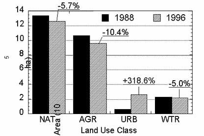
Figure 1. The spatial extent of major land use types in Zhu Jiang Delta region for years 1988 and 1996 as determined by the satellite analysis of Seto et al. (2000). Labels refer to natural vegetation (NAT), agriculture (AGR), urban (URB), and water (WTR) land use classes.
2. Background And Methods
2.1 Description of the Study Area
The study area encompasses the Zhu Jiang River Delta region (ZJDR) in Guangdong Province, People's Republic of China. The boundaries correspond to the Landsat Thematic Mapper scene used in the land use change analysis (Seto et al., 2000). The area covers 2.7 x 10⁶ ha, or approximately 15% of the total area of Guangdong Province. The natural, potential vegetation of the region is predominantly evergreen broadleaved forest (Zhao, 1994).
Over much of the study area, the observed vegetation deviates substantially from the climatic potential. The differences reflect current and historical patterns of intensive land use by humans (Li and Liu, 1994). We focussed our analysis on two of the three non-water land use classes in the Seto et al. (2000) study: natural vegetation (NAT) and agriculture (AGR). We assumed that NPP in the urban (URB) land use class was negligible.
2.2 Modeling NPP with Satellite Data
We used a simple light-use efficiency (LUE) model to estimate NPP (e.g., Waring and Running, 1998; Sheriff et al., 1995). The basic form of the LUE model can be expressed as:
NPP = f·e·FPAR·S. (1)
The S term is the amount of PAR incident above vegetation canopy (MJ m-2). FPAR is a dimensionless term that accounts for the efficiency with which PAR is absorbed by the green, photosynthetic elements of the canopy. The product of S and FPAR determines the amount of vegetation-absorbed PAR (APAR, MJ m-2). The e parameter equals the gross or net amount of plant dry matter produced per unit of APAR (g MJ-1). The f term is a dimensionless factor that accounts for any reduction in e resulting from environmental constraints (e.g., Prince, 1991).
An important feature the LUE model is that the variables S, FPAR, and f can be estimated using existing satellite remote sensing techniques (Goward and Dye, 1996). We validated the model results by comparing them with NPP figures reported in the research literature for comparable ecosystems and environmental conditions.
2.3 Data Sources
2.3.1 Net Primary Production.
We used monthly average normalized difference vegetation index (NDVI) data to estimate FPAR, based on the empirical relationship employed by Ruimy et al. (1994). The NDVI data were from the NOAA/NASA Pathfinder AVHRR Land (PAL) data set (Agbu and James, 1994). Monthly PAR data were from the satellite-derived data set described by Dye and Shibasaki (1995). The spatial resolution of the NDVI and PAR data sets were 8 km and 100 km, respectively. We set the e value for NAT to 1.39 g MJ, based on field data from Peng and Zhang (1995). We set e for AGR to 1.74 g MJ-1, which is value given by Ruimy et al. (1994) for tropical cultivation. Based on available climate data, we assumed that environmental constraints in our study area were negligible and set the value of f in Equation (1) to 1. We referred to the 30 m land use maps from Seto et al. (2000) to select sample locations in the course resolution FPAR images to represent the NAT and AGR land use classes. From the sample data we produced time series of monthly FPAR and PAR values for input to the NPP model.
2.3.2 Carbon Storage.
Our estimates of the carbon content of soils in the ZJDR are based on data reported by Cai (1996). We estimated carbon storage in phytomass in NAT by referring to data given by Chen et al. (1993) and other published sources. For AGR, we referred to data reported by Atjay et al. (1977). The carbon storage data were specified on a per-unit-area basis (density). In the current analysis we assume the carbon densities associated with the land use classes remain fixed at their specified levels during the study period.
2.4 Estimating Regional Effects
To estimate the regional effects of land use change we assumed that ecosystem NPP and carbon storage were spatially homogeneous within the land use classes. We calculated regional changes by multiplying the area-based NPP and carbon storage values by the total land area lost or gained for each land use class.
3. Results
3.1 Validation of NPP Model Results
Based on the observed range of values from field studies reported in the literature, we specified high, medium, and low NPP estimates for NAT and AGR. For NAT, our model estimate of NPP differs from the medium field estimate by +13% (20.5 and 18.2 t DM ha-1 yr-1, respectively). The high quality of the field data used in the NAT comparison strengthens our confidence that our model estimate of NPP is reasonably accurate for NAT. The results suggest that the model was moderately successful in estimating NPP for AGR. Because of shortcomings in the reported data for AGR, caution is necessary when interpreting the AGR comparison results.
3.2 Effects of Land Use Change on NPP
The NPP analysis indicates that land use change in the ZJDR between 1988 and 1996 reduced the annual amount of atmospheric C assimilated into phytomass by approximately 1.55 Mt (-7.5%) (Table 1). More than half (55%) of this reduction is attributable to the loss of agricultural land.
Table 1. LUE model results showing NPP (rate and regional total) for 1988 and 1996, and the net change, DNPPtot. Conversion from dry matter (DM) to carbon assumes .45 g C per g DM.
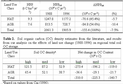
Table 3. Net change in regional total phytomass
(988-1996) based on estimates from reported field data and land use change
(Fig. 1).
| Land Use Class | Net change in Phytomass(104 t C) | ||
| high | med | low | |
| NAT | -1347.3 | -464.5 | -269.1 |
| AGR | -203.4 | -101.9 | -0.3 |
| Total | -1550.7 | -566.4 | -269.4 |
3.3 Effects of Land use Change on Carbon Storage
Our results indicate that conversion of natural and agricultural land to urban uses in the ZJDR from 1988 to 1996 is the source of a release of between 140×104 and 310×104 tons of soil organic C, with a medium estimate of 225×104 tons (Table 2). These figures account for the expected cumulative release during the 20 years following conversion. Patterns of carbon loss observed in studies of cultivated soils (Schlesinger et al., 2000) suggest that the majority of the carbon would be released in the several years immediately following conversion.
Our medium estimate for carbon lost from phytomass is 566×104 tons; the majority (82%) of this was from natural vegetation (Table 3). Phytomass accounted for about 72% of the total of 792×104 tons of carbon released (medium estimate).
4. Discussion And Conclusion
Land use change in the Zhu Jiang Delta region between 1988 and 1996 affected the regional carbon cycle by reducing both the annual rate of NPP and the size of the terrestrial carbon reservoir. The dominant mode of land use change underlying this effect involved the conversion of vegetated land areas (natural and cultivated) to urban uses (Fig. 1). In some types of land use change where vegetation is removed from the landscape (e.g., deforestation, swidden agriculture), NPP can rebound through secondary growth. Vegetation-to-urban land use conversion, however, causes a sustained reduction in the capacity the landscape to assimilate atmospheric CO2. Thus the observed 7.5% decline in annual NPP is a measure of the reduction in the total photosynthetic capacity and carbon sequestration potential of terrestrial ecosystems in ZJDR.
Vegetation removal and soil disturbance in the expansion of urban areas reduced the amount of carbon stored in existing phytomass and soils by an estimated 792×104 t C. In the absence of a compensatory increase in NPP and biomass through secondary growth, this result represents a sustained reduction in the potential size of the terrestrial carbon pool in the ZJDR. The future course of the socio-economic driving forces that influence the rates and modes of land use change in the region (Seto, 2000), in combination with potential climate change, will determine whether these effects become exacerbated or diminished in the coming decades.
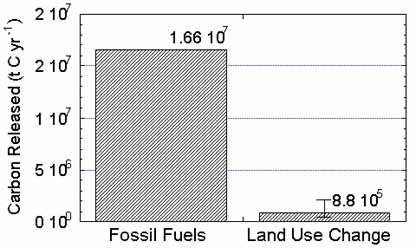
Figure 2. Estimated total amount of carbon released in the ZJDR study area as a result of fossil fuel energy use (1996) and land cover change (annual average, 1988-1996).
Our analysis shows that recent land use change caused significant modifications to the terrestrial ecosystem component of the regional carbon budget in the ZJDR. It is instructive to compare our estimates of carbon released from ZJDR ecosystems to carbon emissions from fossil fuel combustion for the same area and time (Fig. 2). We used energy consumption data to estimate the carbon emissions from fossil fuels for Guangdong Province in 1996 (SSB, 1998). We adjusted this figure to our study area based on the fraction of the 1996 Guangdong gross domestic product (GDP) generated within the area (K. Seto, personal communication). The results indicate that fossil fuel combustion in our ZJDR study area in 1996 emitted about 1.7×10⁷ tons of carbon, which is two orders of magnitude greater than the average annual amount of carbon released as a result of land use change in the ZJDR (8.8×10⁵ t C). Despite significant effects for the terrestrial ecosystems, the role of land use change in the overall carbon budget of the ZJDR is small (5.3%) relative to fossil fuel-based energy consumption.
5. References
- Agbu, P.A., and M.E. James. 1994. NOAA/NASA Pathfinder AVHRR Land Data Set User's Manual. Goddard Distributed Active Archive Center, NASA Goddard Space Flight Center, Greenbelt.
- Cai, Z, 1996. Effect of land use on organic carbon storage in soils in eastern China. Water, Air and Soil Pollution, 91, pp. 383-393.
- Dye, D.G., and Shibasaki, R., 1995. Intercomparison of global PAR data sets. Geophysical Research Letters, 22(15), pp. 2013-2016.
- Goward, S.N., and Dye, D.G., 1996. Global biospheric monitoring with remote sensing. In: The Use of Remote Sensing in the Modeling of Forest Productivity, H.L. Gholz, K. Nakane, and H. Shimoda, eds., Dordrecht, The Netherlands: Kluwer Acad. Publ., pp. 241-272
- Kikuchi, T., Zhan, G., Guo, H., 1997. Land use changes and their driving forces in the Beijing metropolitan area, China. Geographical Reports of Tokyo Metro. Univ., 32, p. 43.
- Li, W., and Liu, Y., 1994. Land use and land cover change in China. Journal of Chinese Geography, 4(3-4), pp. 25-40.
- Peng, S., and Zhang, Z., 1995. Biomass, productivity of climax vegetation on Dinghu Mountains, Guangdong, China. Science in China (Series B), 38(1), pp. 67-73.
- Prince, S.D., 1991. Satellite remote sensing of primary production: comparison of results for Sahelian grasslands, 1981-1988. International Journal of Remote Sensing, 12, pp.1301-1312.
- Ruimy, A., Sugier, B., and Dedieu, G., 1994. Journal of Geophysical Research, 99(D3), 5263-5283.
- Schlesinger, W.H., Winkler, J.P., and Megonigal, J.P., 2000. Soils and the global carbon cycle. In: T.M.L. Wigley and D.S. Schimel, eds., The Carbon Cycle, New York: Cambridge Press, pp. 93-114.
- Seto, K.C, Woodcock, C.E., Song, C., Huang, X., Lue, J., and Kaufmann, R.K., 2000. Monitoring land-use change in the Pearl River Delta using Landsat TM. Submitted to International Journal of Remote Sensing.
- Seto, K.C., 2000. Monitoring and modeling land-use change in the Pearl River Delta, China, using satellite imagery and socioeconomic data. Ph.D. thesis, Dept. of Geography, Boston University.
- Sheriff, D.W., Margolis, H.A., Kaufmann, M.R., and Reich, P.B., 1995. Resource use efficiency. In: Resource Physiology of Conifers, W.K. Smith and T.M. Hinckley, eds., New York: Academic Press, pp 143-177.
- STB, 1998. China Energy Statistical Yearbook, 1991-1996. Dept. of Industrial and Transportation Statistics, State Statistical Bureau, People's Republic of China, China Statistical Publishing House, Beijing.
- Waring, R.H., and Running, S.W., 1998. Forest Ecosystems: Analysis at Multiple Scales. New York: Academic Press, 370 pp.
- Zhao, S., 1994. Geography of China. John Wiley & Sons, New York, 332 pp.