| GISdevelopment.net ---> AARS ---> ACRS 2000 ---> GIS & Data Integration |
Harnessing Information
Technology for (Geo)Management and Decision-Making
Rowena Bassi Quiambao, Tran
Hung, Yoshifumi Yasuoka
Philippine Institute of Volcanology & Seismology
C.P. Garcia Street, University of the Philippines, Diliman,
Quezon City 1101, Phillipines
Tel: (632) 426 14 68 to 79/Fax: (632) 920 70 58, 927 45 24
Emails: weng@phivolcs.dost.gov.ph
Philippine Institute of Volcanology & Seismology
C.P. Garcia Street, University of the Philippines, Diliman,
Quezon City 1101, Phillipines
Tel: (632) 426 14 68 to 79/Fax: (632) 920 70 58, 927 45 24
Emails: weng@phivolcs.dost.gov.ph
Keywords: geoinformation, infrastructure, quality management, information technology, decision-making
Abstract
The use and access of GeoInformation (GI) at an affordable cost demand the creation of an infrastructure. Creating a GeoInformation Infrastructure (GII) requires consideration, if not total solution, of the most basic issues on its design. Optimal utilization of the incessant and radical Information Technology (IT) should be geared towards the facility of the flow of information from the sources to the users. With the influx of multitudes of GI, there is a requirement to develop a GII for the information-based society. Geoinformation companies in the government are providing GI as their public service. Such an organization is known as a GeoInformation Utility (GIU). For whatever type of geoinformation service, a GIU needs to consider the proper use of IT. This entails the thorough examination of the dimensions of its overall quality - data and organizational or institutional. Such scrutiny of the overall quality of a GIU should lead to its better procedures. With a better overall performance by the providers of the GI, the users will be able to obtain optimum data. The proliferation of high-quality geoinformation leads to rapid and reliable decision-making. The GI-based society should be well supported by existing GIUs, which, in turn, comprises part of the entire GII. The workable solutions to GI-related problems should put the society or country in a position capable of sustainable national development.
1 Introduction
Information is a vital component of managerial and/or decision-making activities because it provides the answers to specific questions arising from problems within a system. The system is composed of people, hardware, software, and programs organized to perform and accomplish a specific set of functions or applications. In order to accomplish a specific question and function within an organization, for example, the people in the organization make use of the available hardware, software, and procedures to come up with the information needed. Good management of production process within an organization is highly reliable on efficient and effective use of information. It has been known that information technology (IT) is a key resource for modern, business-oriented organization although it is a costly resource. Good results from a decision-making process can be attributed to the generation of a good information. Thus, there exists a high dependency between information quality and information system development. It can be said, therefore, that a critical success factor for an organization is the methodology used to develop the information system.
Most geoinformation specialists have agreed that there is a requirement to develop a GeoInformation Infrastructure (GII) for the information-based society. The design of a GII requires commitment and involvement from the GI community, users and providers of data, the public and private sectors, the academic community, the professionals working in the field and also from responsible politicians and top civil servants (Berends, 1996).
2 The GII
Several definitions for the phrase "GeoInformation Infrastructure" have been written and published that stating one definition here would seem to invalidate the others. Thus, it would be more appropriate and fitting to mention some characteristic elements of a GII as used in the literatures. GII has been taken to include various software, hardware, human resources, the actual spatial data, policies, agreements, standards, administrations, management, the knowledge and the technology to make all of these elements to work together in the pursuit of the objectives of its design. A GII serves the purpose of facilitating the efficient access and responsible use of geoinformation at an affordable cost. It enables the capability of transporting large quantities of data at high speed. It is interesting to note that most of the professionals in the geoinformation field recognize the importance of the human element in the definition of a GII (Latimer). They acknowledge the necessity of the technicians that keep the GI system going, the professionals that show how to use the system and software, the community that supports the purchase of the hardware and the professional support (politicians and civil servants) that share ideas and problems.
With the establishment of a GII, several problems on the use, access, cost, availability, accuracy, reliability, and acceptability of the geoinformation could be solved or even just remedied. The technical, institutional and economical matters related to geoinformation are to be resolved with the proper management of a GII.
It is a common eventuality that individual organizations are forced to duplicate efforts in acquiring geoinformation that are already in existence in other organizations without a working information infrastructure. The results are staggering in terms of economic loss, wasteful duplication of efforts, loss of information sharing and loss of data integration capability in support of decision-making activities (Sharifi, 1993).
3 Issues Related to the Design of a GII
3.1 Technical Issues
Information Technology (IT) products form important building blocks for using geographic information. The technology concerns computers, software, techniques, and networks working all together. The rapid development of electronic data communication gave new impulses to GII and created fresh opportunities (Berends, 1996). There is a need to continuously research and develop on the necessary technology for building and using effectively the GII. Included in this are the application testing of the infrastructure, what system to buy, the compatibility with other systems and data, which data is the best and which data to use. Included in the technical viewpoint of the design of a GII is the issue on structural aspects of geoinformation. It involves relationships between terrain features, their thematic attributes, and their geometry. A feature classification system could be established such that the three key characteristics of a geoinformation - terrain feature, thematic attribute, and geometry - will be efficiently defined and interrelated. Furthermore, the linkage between thematic data to geometric data could be resolved (Molenaar, 1991).
In response to the technical issues on how to meet the increasing demands of building an infrastructure, there has been suggestions to design the infrastructure modularly and add to it as necessary using technology which precludes the need to redesign and reengineer after each upgrade (Infrastructure Question #4, Internet article).
Institutional Issues
When institutional issues on the design of a GII are taken, this involves a multi-dimensional perspective. Questions on the following topics are common in the discussion of institutional issues:
- the organizations' policies, functions and mandates;
- inter- and intra-relation of the organization with others; and
- education and training of human resources.
External issues concern the access and usage of the geoinformation (who are allowed to participate in the access and use of the geoinformation?); the definition of a user and a provider (who is supposed to give, use and provide the geoinformation?); and management/ministerial concerns on the relationship with outside organizations or individuals.
The GII should be able to address institutional issues within the (members of the) system, or internal issues, and outside the system, or external issues. Internal issues are organizational ones some of which are as follows:
- bureaucracy which blocks the flow of information;
- resistance to change by personnel due to ignorance and worry on costs rather than increasing benefits;
- redundancy due to overlapping functions;
- incapability of specialists to address details of a project; and
- underestimation of the need for expertise.
It is often a question of whether the members are complying with the jobs that they are supposed to perform and whether they do their jobs in such a way that the standards are followed (Groot, lecture on GII, 1996).
Economical Issues
It has been noted as a common factor for the success of national economies and cross border regional economies the dependence on the capacity to access and use in a multidisciplinary way large amounts of data, statistics and spatially-referenced information (Sharifi, 1993). In itself, the term "infrastructure" is used as the capital investment needed to create the structures and services to make access to and use of geographic information efficiently possible (Groot, 1990). In this sense, economic issues are relevant to be considered and solved for the design of a GII.
Cost and benefit analysis of the whole GII entails the economic issues such as developmental, operational and maintenance cost of the system. It is imperative to define the source of funding and/or financing to be utilized in the design of a GII. With the cost issues resolved, tangible and intangible benefits could be obtained leading to fewer tasks and people involved, information being more rapidly available, higher quality of goods and services, more conclusive and rapid decisions, and better-used information.
4 On Geoinformation Utility and Quality Management
A definition of a Geoinformation Utility (GIU) is given as "an infrastructure set up for the efficient distribution of data/information to enhance its availability, accessibility and use at an affordable cost" (Addai, 1995). There are certain characteristics of a GIU to perform well in terms of: 1) adhering to the objectives, mandates, duties, and responsibilities; 2) its users' requirements; and 3) the existing issues and constraints that are binding to the utility. In a study by Wang and Strong, a hierarchical framework for organizing data quality dimensions was developed which captures the aspects of data quality that are important to data consumers. The four dimensions of data quality that are important to data consumers are as follows:
- Intrinsic data quality which denotes that data have quality in their own right;
- Contextual data quality which highlights the requirement that data quality must be consideredwithin the context at hand;
- Representational data quality which includes aspects related to the format of the data andmeaning of data; and
- Accessibility data quality, which answers the question on the extent to which data areavailable or obtainable.
- establishment of communication protocol;
- commercialization of products and services
- proper management and maintenance of the Geographic Information System
- (GIS).
Decision-making has acquired a convenient tool in the access of the needed data through advancements in the information technology. Individual autonomous databases have been integrated at various proportions by the advent of advances in digital technology. Sharing of geoinformation has become possible as newer and more sophisticated computer systems and networks are being designed. These are among the cumulative, positive results of the great big bandwagon of information technology. All around the world, users and providers of spatial data have either started to embark on discussions about geoinformation or are about to start. It is becoming a national concern in most countries due to the fact that the groups involved are concerned with national matters as much as with their own local problems.
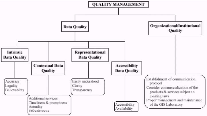
Figure 1. A Conceptual Framework of Quality Management for a Geoinformation Utility (GIU) (modified after Quiambao, 2000)
Proper utilization of geoinformation leads toward an effective management of an information system. With high-quality geoinformation on hand, it is a valuable input for decision-making tasks. The results obtained from decision tasks prove to be of equal effect whether for a small organization or for the national-level entity. That result is basically just between two judgements - the good and the bad. Good benefits result from a good decision. And the inverse is true for a bad decision. The demands incorporated in arriving at a good decision are quite high such that improved techniques have to be used to arrive at one. The consequences of the results from decisions are becoming more and more daunting as the overall quality of the geoinformation becomes less and less.
Some applications of generated geoinformation that is used as a tool for decision-making include selection of sites suitable for some purposes; assessment of land areas for hazard protection scheme; classification of satellite images for land evaluation; and even simple comparison of geoinformation attributes, both in time-related and quality-related dimensions.
6 Conclusions
The need to develop a workable framework for the integration of the geoinformation based on the requirements, needs, and resources of the users and providers is answered by the establishment of a GeoInformation Infrastructure. The design of a GII is a multi-layering of technical, institutional and economic aspects. It could not be achieved by just considering one or two main issues but by an integrated and collaborative analysis of all the three concerns.
The technical know-how of running a geoinformation system could not be guaranteed to ensure success if the institutional structures and mechanisms of its development, operation and maintenance will not be properly implemented as well as the provision of the needed economic and financial support.
A GeoInformation Utility (GIU) should be able to provide better service if, first and foremost, the requirements by the users of its GI products will be satisfied. The basis for the performance of a GIU and its quality management relies heavily on the users' end. On this context, there is a need for a GIU to satisfy the requirements of the users of its GI products in order for it to function as a better GIU.
The quality management of a GIU encompasses issues ranging from technical, institutional, social, economic, legal, political, managerial, and educational. These issues are all relevant to the quality of the information; to the quality of the processes which these information are obtained and produced; to the quality of the way all the procedures involved are handled: and to the overall quality of a GIU as a service-organization, as a group of people. Problems to these issues should be well identified and resolved.
Emerging as an important tool for decision-making, proper utilization and management of information technology should be well supported by the existing GeoInformation Utilities.
References
- Addai, P.A., 1995. Selection of an Optimum Methodology for the
Development and Maintenance of GeoInformation Utility. ITC, MSc. Thesis,
Enschede, The Netherlands.
- Berends, J. & Kok, B., 1996. How to Raise Political Support for
the Development of a National GeoInformation Infrastructure. In:
Proceedings of Second Joint European Conference & Exhibition on
Geographical Information, Barcelona, Spain, Volume 2.
- Groot, R., 1990. From Geodesy to Geomatics: A Challenge of
Information Society.
- Groot, R. Lecture on GII, ITC, 19 February 1996.
- Infrastructure question #4. Internet article.
- Latimer, E., Mississippi State University, Summary of
Infrastructure-Question 1. Internet article.
- Molenaar, M., 1991. Status and problems of geographical information
systems. The necessity of a geoinformation theory. ISPRS J.
Photogrammetry. Remote Sensing, volume 46, pp.85-103.
- Quiambao, R. B., Quality Management of a Geoinformation Utility: the
Users' Perspective. In: Proceedings of the 19th Congress of the
International Society of Photogrammetry and Remote Sensing (ISPRS),
Amsterdam, The Netherlands, 16-23 July 2000.
- Sharifi, M.A., Groot, R., GIS Infrastructure: An Essential Element
of Successful Development and Transfer of GIS Technology. In:
Proceedings of the 14th Asian Conference on Remote Sensing (ACRS),
Tehran, Iran, 10-17th October 1993.
- Wang, R.Y. and Strong, D.M., Spring 1996. Beyond Accuracy: What Data Quality Means to Data Consumers. Journal of Management Information Systems, volume 12, number 4, pp.5-34.