| GISdevelopment.net ---> AARS ---> ACRS 2000 ---> GIS & Data Integration |
GIS for Visual Impact
Assessment
Zongyu Zhang, Jin Yeu Tsou, and Hui Lin*
Department of Architecture, Geography*, The Chinese University of Hong Kong,
Shatin, Hong Kong, China
Emails: s992332@mailserv.cuhk.edu.hk, jinyeutsou@cuhk.edu.hk, & huilin@cuhk.edu.hk
Zongyu Zhang, Jin Yeu Tsou, and Hui Lin*
Department of Architecture, Geography*, The Chinese University of Hong Kong,
Shatin, Hong Kong, China
Emails: s992332@mailserv.cuhk.edu.hk, jinyeutsou@cuhk.edu.hk, & huilin@cuhk.edu.hk
Keywords: Visual impact assessment, urban landscape, GIS
Abstract:
As an important component of urban landscape planning, visual impact assessment is mainly concerned with: A. the direct impacts of the development upon views of the landscape through intrusion or obstruction; B. the reactions of viewers who may be affected; C. the overall impact on visual amenity, which is often cumulated by plenty of minor process and can be range from degradation through to enhancement (IEATLI, 1995). In this article, the dichotomy of quantitative methods and 3D simulation for visual impact assessment are exposed based on the review of previous work and the characters of visual impact on urban landscape (Wherrett, 1996). Although these two methods are different greatly in software choosing and operational processes, they both aim at improving the preciseness and efficiency in capturing the impact to original landscape and public responses. The integration of both in one system is desired for visual impact assessment on urban landscape. Geography Information System (GIS) excels in the integration of quantitative and 3D simulation methods. The specifications for such a specific GIS are elicited. In includes the considerations on system functions, data management, project management, and user interface design. An experimental GIS system for visual impact assessment is also developed to test the feasibility of such integration.
1. Introduction:
The fast development of society accelerates the transformation or urban landscape. As an important facet of society and environment, the urban landscape's visual quality is attracting people's attention. To favour people's appreciation for high quality urban landscape, urban planners improve the visual sustainability in urban natural landscape and maintain valuable natural landscape resources with high visual quality in urban space . Urban visual landscape evaluation includes three major problems: the technical problem of how to visualise possible changes in the landscape; the theoretical problem of how to evaluate scenic beauty; and the administrative problem of how to integrate visual aspects in the planning process (Lange, 1994). In the past, planners emphasize on the analysis of people's preference on natural landscape and beauty degree evaluation of it (Wherrett, 1996). One the basic facets of urban landscape evaluation, visual impact assessment, however, have been overshadowed. Visual impacts relate solely to changes in available views of the landscape, and the effects of those changes on people. They arise from the changes in land use, the development of buildings and structures, changes in land man-management, and less commonly, the changes in production process and emissions. In addition, in the life of a project, many different sources of impact occur at various stages, that is during construction, operation, decommissioning and restoration. " Visual impact assessment is an important component of landscape planning and its part of process which seeks to provide the best 'environmental fit' for a development."(IEATLI, 1995) 3D simulation and quantitative analysis play important roles in the assessment of visual impact. Quantitative analysis for visual impact assessment includes view shed and indivisibility calculating. Its output can be projective maps, which are initiated from viewpoints within the development (inside looking out), or reflective mappings, which are initiated from viewpoints in the surrounding landscape (outside looking in). Objective of the former is to reveal the extent of visibility of the development to its surroundings. And the latter's objective is to determine whether, and to what extent, the development is visible from its surroundings. There have been few comprehensive programs to incorporate the visualization tools into environmental resource modeling system, nor to systematically evaluate the usefulness and applicability of such systems to agency and public decision making settings. In some areas there are comprehensive resource models, but lacking visualization capabilities in others there are well developed visualization tools but poor links to quantitative modeling (Orland, 1992a). Recently, situation seems the same. Homana developed specific Geographic Information Database for landscape evaluation (Homma et al, 1999). They utilized professional GIS software to accomplish the view shed and visibility precise calculating, but lacked in the simulation. Tsou integrated CAD, QuickTime VR and Visual Studio to assess the visual impact of the construction of one electronic substation, while did not analyze in quantitative (Tsou, 1999). Situation shows the importance of the integration of both simulation and quantitative analysis. CAD software shows efficiency and effective in the complex scene simulation. It maps the image as texture to improve the vivid of simulation. The scene can also be animated into movies or high-resolution picture by so called ray-tracing technology. Recent developed technology called quick time VR is an image based panorama. By merging the documentation of the existing site environment with photos and QuickTime VR (QTVR) panoramas with CAD models, the future scene of that site can be rendered. Quick time VR allows some kinds of predefined interaction such as rambling in the virtual reality. Aimed at design assistant, CAD lacks in so called spatial analysis and precise simulation of 3D terrain. That makes the frequently computation of view shed analysis in visual impact a heavy task. Long as geo-analysis directed software, GIS excels in the spatial analysis. By the integration of both spatial analysis and 3D analysis modules in GIS, users are empowered to complete viewshed or visibility computation. The visual impact of new developed constructions or feature planning to specific features can be demonstrated by overlay the feature maps with view shed map. To those who only interested in 3D simulation, developers can customize GIS software with includes 3D-analysis extension to crater to their requirements. In addition, directed by so called engineering theory, GIS excels in project management. Which can also release those who work on visual impact assessment a lot. In this article, the integration of both simulation and quantitative analysis in a specific GIS for visual impact assessment will be discussed based on GIS's 3D analysis and spatial analysis extensions.
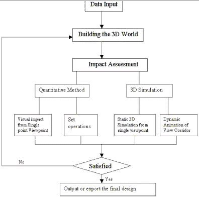
2. Specifications elicited for system design (Capturing the requirements)
It includes the considerations on database and user interface design, and emphasizes on project management, interactions between 2D analysis and 3D simulation, the integration of quantitative analysis and 3D simulation.
2.1 Function Requirements
The visual impact assessment of a proposed development addresses three types of issues: spatial, quantitative and qualitative. Spatial issues include where the development is visible from or, more specifically, what or whom it is visible to; quantitative issues include how much of the development is visible, how much of the surrounding area is affected, and to what degree; and qualitative issues include the visual character of the development and its compatibility with its surroundings. The first two issues can be due to the changes of the indivisibility for given development. The qualitative facet of the visual impact assessment lies more on people's subjective judgement and is hard to be quantified. In addition, the last one is also based on the outcome of the former two analyses. Homma et al (1999) utilized some specific mathematical model called Analytical Hierarchy Process (AHP) to assist the evaluation of visual impact from a designed garbage processing plant based on the prior viewshed analysis. The principle of indivisibility states that visibility is determined in two ways either from the site or to the site. It includes both being viewed from outside of the development's boundaries and the outside view from the developing site to adjacent areas. In GIS's 3D analysis extension, they are both under the calculation of viewshed . Viewshed includes all visible or invisible area in the city from given viewpoints or view corridor (ESRI, 1997). View corridor means the corridor from the viewpoint to the scenery. In the urban area, view corridor often follows the route of roads, sidewalk of rivers, or some other linear. In landscape design, visibilities between scenery are often maintained for good visual effects. It is also necessary to maintain some visual relations between important landscapes in order to form the whole visual landscape effects. View corridor shows the dynamical characters of urban landscape. Different with static analysis of indivisibility calculation and its low efficiency in the demonstration of view corridor analysis, 3D simulation exhibits dynamically the variations of scenery when walking along the view corridor by animation. View corridors affect the layout and height of buildings. They also have effects on the layout of plant. Besides the view shed and view corridor, there are also some other factors should be considered in design a specific GIS for visual impact assessment. In the city, areas show great differences in their magnitude of visual values. Even when it comes to a same building, some façades contribute more to its visual character. Those make it necessary to level constructions according to their visual values. And the visual impact of new constructions should also involve the parts which intercept with those prior parts.
2.2 Project Management
From the viewpoint of engineering, the process of urban planning or some other urban visual environment impacting projects can often be divided into three parts: capturing the requirements, feasibility analysis and design. Visual impact assessment often stands in the front part of them. It reveals the degrading or improvement of urban planning projects to the original urban landscape. In the first stage of those projects, planners interview, poll or do some other investigations to infer the customers' requirements for the project, and form the project's norms and specifications. All limitations are analyzed in the following process to weigh the feasibility of that project. It includes the future expenses, national and regional polices, natural environment of the site and some other objective qualifications. The design is then modeled to simulate the future situation and also is assessed for its visual impacts. If those who concerned are satisfied with the design, planners can congratulate on their success; otherwise, they would have to repeat the whole process from beginning. Which often makes the whole project a lengthy and reciprocate process. And it also shows as an important part of the whole urban planning, visual impact assessment should be managed in projects. GIS assists planners to quickly capture their customers' requirements for desired visual environment, even if people just have some vague pictures of what they want. Actually it is often hard for them to imagine the outcome of planners' design based on maps, and discussion or some other well-organized communications can often invigorate their inspiration for what visual environment they desire. GIS and the WWW are ever evolving technologies with the potential for public use allowing greater involvement in environmental decision making and "they can design GIS primarily for expert use or they can make them accessible to the lay professional and even to the general public". When connected with Internet, GIS grants people to live talk with all those who concerns the site planning. What's more, the web based GIS models the future scene of the planning site in either two-dimensional or three dimensional forms and broadcast them on web page, people can have a vivid impression on the outcome of the project. People can express their opinions by sending email or attend an online live chat and all those communications are logged and feedback to planners to rectify their design. All those contribute a lot to clarify and pinpoint people's subjective attitude to the impacted visual environment based on GIS's objective quantitative analysis and 3D simulation ability. The inner character for broadcasting to public of visual impact assessment desires more on web based GIS. For the consideration of quickly prototyping, it is desired to integrate both the design and the evaluation modules into one system. But popular GIS system shows low efficiency and inhabit to those used to finish their design on CAD software. Import of data from another kind software challenges greatly the inter-operatibility of GIS. Although many popular GIS software, such as Arc/Info, Arcview or MapCAD, have specific extension for the import of CAD data, the semantics of data structure defined in GIS and CAD are differentiated. Thus makes it also important for developer to customize the imported data from other software to be GIS style. The reverse situation seems the same. The outcomes of visual impact assessment are often stored in the database as electronic maps. It needs to be reversed transformed into CAD or other software data format according to their semantics.
2.3 User Interface
Many commercial GIS software provides the allowance for developers to customized the user interface according to specific requirements. Following the current software's Window's style, the user interface of the specific GIS for visual impact assessment should be graphical. However, the gap between the system and public still exits. It comes from the unfamiliarity between public and GIS. That challenges the specific GIS for VIA not only in the system functions but also the user interface and system work style. The latter often contributes more to the public's acceptance for the specific system. In this article, a specific query language, which extends the SQL, is designed to facilitate planners in VIS process The extended SQL is aimed to be in oral style and accompanied by some jargon in VIA, which makes it easy to understand. Its architecture is transferred from standard SELECT-FROM-WHERE form into SELECT-FROM-WHERE-WHAT IF format. The input of query statement can be in text or visual design in customized Java Applet panel. The latter empowers user to interact with spatial objects on the displayed map while accomplishing the query statement. For example, to finish the query on visible area from given viewpoint, user can set up the view point in the WHERE clause by selecting its Id code in the candidate listbox or directly pinpoint it on the map. We map the specific spatial analysis for VIA into meta-operations of the extended SQL. It includes the viewpoint selecting, view shed analysis, and set operations. The user's interaction with themes or spatial objects on the map is also introduced into the SQL statement's formation. For instance, to answer 'what if' questions, system empowers user to do some editing operations on line or polygon objects in the active theme. The result will be included by the WHAT IF clause.
3. Case System
An experimental GIS system has been developed to test the method of integration of both quantitative method and 3D simulation for visual impact assessment by customizing the Arcview 3.1 with spatial analysis and 3D analysis extensions. Spatial objects stored in the Database Management System (DBMS) are first classified according to their significance in global or local urban landscape. And also main façades of buildings, which contribute more to their scene character, are identified. The categorical system for the features can be listed as below:
| Categorical | Contents |
| Natural landscape Resources | Natural parks.Community gardens.Recreation facilities |
| Humanities landscape resources | Scenic spot.Shrine and temple |
| Public utilities | Public Office.Schools.Hospitals.Public Hall.Harbours |
| Resident Areas | Residential quarters.Apartment houses |
| Public Transportation | Main local road.National roads.Railway tracks |
| Planning project | Draft of the constructions design.Reshaped Terrain |
4. Preliminary finding and future work:
The experiment GIS system demonstrate the feasibility in the integration of both quantitative analysis and 3D simulation for VIA. It is illustrated by the identical viewpoint in both the two dimensional view for quantitative analysis and the 3D scene for simulation. The comprehensive utilization of set operations for visual impact detection effectively exposes the cumulative visual impacts. However, the system still shows its limitations and should be improved in the future.
- The representation ability of GIS in three dimension for complex scene shows less vivid.
- As mentioned before, VIA characterizes in its public. It is more desired to transfer the whole process from desktop to Internet. Currently, popular web GIS platform shows limit in provide complex analysis service and also lacks in 3D simulation.
- Different from the popular computer aided architecture design software, GIS lacks the flexible toolkits to support design. Some minute edit tool such as changing spatial objects' positions, dimensions can also benefit a lot for quick design prototyping.
- Arcview 3D Analyst, 3D Surface Creation, Visualization, and
Analysis. Environmental System Research Institute INC( ESRI) .
- Institute of Environmental Assessment and The Landscape Institute
(IEATLI), 1995 Guidelines for Landscape and Visual Impact Assessment.
First Edition. London: E&FN SPON, and imprint of Chapman&Hall.
- Homma, R., IKI,K., Morozumi, M., and Morisaki, T. 1999. Geographic
Information Database for Landscape Evaluation. Proceedings of the Fourth
Conference on Computer Aided Architecture Design Research in Asia.
Shanghai Scientific and Technological Literature Publishing House.
- JEFF W.T.Kan, BENNY K.M.CHOW, and JIN-YEU,TSOU,1999. Visual Impact
evaluation of electricity substation architecture. Proceedings of the
Fourth Conference on Computer Aided Architecture Design Research in
Asia. Shanghai Scientific and Technological Literature Publishing House.
- Lange, E. 1994 Integration of computerized visual simulation and
visual assessment in environmental planning. Landscape and Urban
Planning, 30, PP99-112.
- Orland,B.(1992a) Data Visualization Techniques in Envrionmental
Management. Landscape and Urban Planning, 21, 237-244.
- Orland, B.(1994) Visualization techniques for incorporation in
forest planning geographic information systems. Landscape and Urban
Planning, 30,83-97.
- Wherrett, J.R., 1996. Visual Impact Assessment. Visualization Techniques for Landscape Evaluation Literature Review. http://bamboo.mluri.sari.ac.uk/~jo/litrev/chapters.html.