| GISdevelopment.net ---> AARS ---> ACRS 2000 ---> GIS & Data Integration |
The Management System
Development of Campus Facility Information using Web-based GIS
Myung-Hee Jo · Sung-Joong Park · Mal-Suk Kim · Yun-Won Jo
Department of Geodetic Engineering, Kyungil University
33 Buho-ri, Hayang-up, Kyungsan-si, Kyungsan bukdo, 712-701, Korea
Tel) +82-53-850-7312, Fax) +82-53-854-1272
Email: mhjo@bear.kyungil.ac.kr, sjpark@tksun.aiit.or.kr, sukkim@cuth.cataegu.ac.kr, gerry@purple.knu.ac.kr,
Key Words: Web-based GIS, Facility Information Management, Intranet, GUI
Abstract
This paper, which deals with the developmental result of university facility management system using GIS, is to verify the developmental process of this system and merits of GIS facility management system. It makes possible for GIS facility management, as a discipline in this paper, to put together the facility managers' works in offices and physical workspaces. Thus, they can administer and manager spatial data and attribute data more effectively and systemically.
Moreover, anyone, even doesn't have any knowledge of computer, can easily operate, input and modify data because GIS facility management system introduced in this paper is implemented and focused on the GUI(Graphic User Interface) effectively.To implement this study, many kinds of drawing layer in campus facility and building including surrounding area. In addition, Oracle Server was used for client and server environment and develop the GUI needed for operating GIS facility management system using Map Object 2.0 GIS S/W and Visual Basic 6.0. To develop the web based GIS for campus-life information system, IMS(Internet Map Server) was applied to integrate GIS and Internet.
Introduction
The definition of Internet GIS (Geographic Information System) is that input, manipulation, analysis, output of geographic data can work on Internet. Recently the use of Internet GIS (Geographic Information System), which is geared with Internet and GIS, is on the increase because of services of GIS data on web, non-limitation of platform, low cost of installation, and extension of it.
Shin. S.Y(1999) installed the stream information using Internet GIS for water analysis, Andrew Evans(1999) and Keng-Pin Chang(1997) constructed system based on web for each public democratic involvement and Community Participation.
The purpose of this paper is to develop the Management System of Campus Facility Information using Web-based GIS so that the limitation of use for only domestic users in specific area under LAN environment overcomes. In addition, it makes to verify the efficiency of this system as comparing with traditional facility management system. Moreover, even general users can grasp geographic information visually by searching spatial data with its attribute data. Furthermore, the technology to search of spatial data on network is needed.
Data and Method
The surrounded area of Kyung-il University and Ha-yang town for study is selected. And then the information of this area was installed and constructed on Internet GIS.
Most of all database including various and detail spatial data and its attribute should be built in GIS DB.
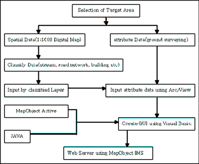
Figure 1. the study flow
The spatial data is classified as stream layer, road layer, and buildings layer based on 1:1000 digital map and has .shp file format on ArcView 3.1. For the attribute data, information of each building such as name and phone number etc. is regarded and input to shape file.
Moreover, GIS facility management system introduced in this paper, which is focused on the GUI(Graphic User Interface), is implemented on Map Object 2.0 GIS S/W and Visual Basic 6.0 and use JAVA language to show the result on web-browser.
Also, it is linked with MapObject IMS(Internet Map Server) to integrate GIS and Internet. The web server to manage spatial data and attribute data is setup on Windows NT 4.0 workstation and Microsoft Explorer for client is installed on Pentium PC.Fig.1 shows the flow of research.
The Management System Development of Campus Facility Information using Web-based GIS
The most important thing to regard when design user interface is to specify function for suitable operations. The general functions for Management System of Facility Information are movement, magnification, reduction, searching, and viewing the attribute.
GIS ActiveX control could be called small size GIS programming, having the ability of computation and transmission, and its own graphic interface. Also, it can be added to any types of application.
The operation of this is similar to other plug-in program. This module is stored at sever and forwarded to web-browser in case of need. When web-browser realize GIS data, this module operates ActiveX control, which is referenced HTML. Map Object IMS is working in above way. Fig.2 presents the implementation diagram of the Internet GIS.
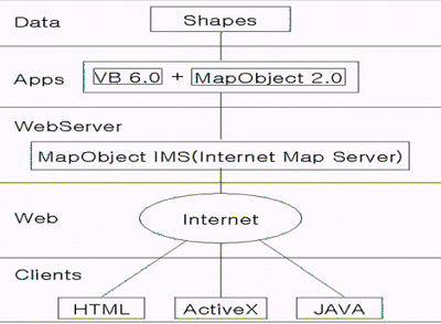
Figure 2. Implementation diagram of the Internet GIS
As shown in Fig.2, HTML, Java, ActiveX are used to access to spatial data on Internet and to process. Finally, the result of processing is shown on web-browser in raster type. Fig. 3 and Fig.4 shows the result of our Management System of Facility Information based on Web.
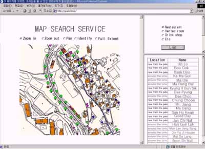
Figure 3. the list of facility information
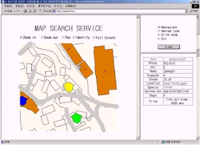
Figure 4. the view of facility information
The Fig. 5 script tells you that the transmitting data to web browser through Web Link object in Map Object.
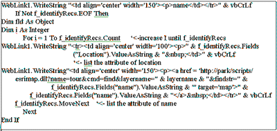
Figure 5. The script with weblink object
Conclusion
In this paper Management System of Facility Information based on Web is implemented so many people can share these GIS data. This system performs perfect searching so this system is expected to use in many ways.
This research shows that Web-based GIS is a useful vehicle for accessing distributed spatial data and conducting GIS processing and spatial modeling among a particular user community by removing geographical and physical constraints to involvement and reducing the need for users to own the data or software system. This study also gives us a research insight into the applicability of Web-based GIS in developing open spatial decision supporting systems where a decision-making process in solving spatial problems demands significant input from the public. The GIS research community is looking for new challenges in future developments of Web-based GIS in terms of users, developers, and institutions.
References