| GISdevelopment.net ---> AARS ---> ACRS 2000 ---> GIS & Data Integration |
An Implementation of 3D GIS
on web
Tien-Yin Chou*?Lan-Kun Chung**?Wen-Yuan Ku***?Wei-Yuan Lo***
*Director, **Lecturer, ***Researcher of GIS Center, Feng Chia University, Taiwan
Tel: 886-4-4516669 Fax: 886-4-4519278
Email: msie@gis.fcu.edu.tw, yaolin@ntcp.up.ncku.edu.tw, eva@ntcp.up.ncku.edu.tw
Tien-Yin Chou*?Lan-Kun Chung**?Wen-Yuan Ku***?Wei-Yuan Lo***
*Director, **Lecturer, ***Researcher of GIS Center, Feng Chia University, Taiwan
Tel: 886-4-4516669 Fax: 886-4-4519278
Email: msie@gis.fcu.edu.tw, yaolin@ntcp.up.ncku.edu.tw, eva@ntcp.up.ncku.edu.tw
Key Words: 3D GIS, VR, VRML
Abstracts:
3D GIS is the best way to display and exposure the z-value of the spatial object and let the analyst or decision maker to recognize the shape of these spatial objects, and web-based 3D GIS is also a hot topic since 1997. To accomplish the goal of 3D GIS on web, VRML is always discussed and implemented, but traditional VR emphasizes the expression of the object or scene, and usually ignores the attribute data behind the spatial object. This research introduce a solution to convert the 2D spatial data to VRML and keep the attribute data anyway, so that user can just browse a 3D scene on a browser and query the attribute data of each spatial object.
I.Introduction
It would be a tendency that GIS more internet and data more vision . Nowadays , we can find many successful GIS website in internet , for example : Taiwan Map (www.map.com.tw)?EasyMap of Taichung (www.easymap.com.tw)….. but all of them only can display geographic information to user by 2D , and cannot present more close real world to user . At present , GIS vision only can use by PC and less to use in internet , the reason is to use 3D technology in WEB GIS till have many problems not solved yet .
The research follow the tendency of GIS , and base on the subject of internet and data vision to study 3D GIS ON WEB solution . We expect can have more edification for the people who are interested in GIS technology research .
II.Review of 3D GIS on web
At presently, the research of 3D GIS on Web is base on VRML (Virtual Reality Modeling Language). It's take account of two factors?
- 1. VRML is a platform independent file format for sharing 3D
worlds on the Web.
VRML browsers or plug-ins are available for all major platforms. User may find browsers and other VRML tools for their system. And they could view 3D scenes on the web.
- 2. Reduce the load of researcher.
In general, it's not an easy work to design a good drafting engine for the domain of three-dimensional graphics. The development of VRML is an exciting piece of news. It's an unnecessary work to waste time on drafting engine. Developers only need to consider converting 2D data format into VRML format and they will accomplish the purpose about 3D GIS on Web.
The first method? converts the 3D scene into a set of files in VRML format with GIS software.
Bo Huang, who studies in The Chinese University of Hong Kong, have made a study of ArcView with its 3D Analysis and Internet Map Server. Mr. Huang developed a complete application, GeoVR, by these two extensions. If users connect the home page serve 3D GIS functions, they could convert 2D data format of the area they allocated into VRML format and return to their computer immediately.
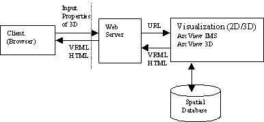
Fig 1. Bo Huang's Structure
It spends the shortest time to generate a 3D GIS with this method. But there are two chief defects?
- We have to expend large sums of money in purchasing 3D Analyst and Internet Map Server extension.
- We can export a 3D scene to the VRML files by ArcView 3D Analyst. But each independent spatial object of this theme is treated as a unique object, and therefore couldn't be queried by users.
To solve the above-mentioned problems, Scott A. Carson brought up an idea. He applied some software and data format like Adobe Illustrator to convert a GIS data to a 2D data format VRML. And then use the extrusion tool of MetaCreations Ray Dream Studio to extrude the building. Last, save the file into VRML format and link attribute data to every object manually.
Then, we followed Carson's method to reform the processes for generating a VRML file. The following are these steps:
- Export a polygon shape file (ex. school's layout) to *.ai format.
- In Adobe Illustrator, export *.ai format to *.eps format.
- In 3D Studio Max, import this .eps file and extrude every building manually and then export to VRML
- Link attribute data to every object manually.
- It seems to be a sticky process. And we must extrude every object manually.
- It never mentioned the method of link attribute data.
- VRML and 2D GIS data structure analysis
- Transfer 2D GIS data to VRML
This topic focus on the method which can present each 3D spatial object in a economical way - Keep the attribute data during the process of transferring 2D GIS
data to VRML
This topic is the most important issue in this research, because a complete GIS data is consisted of spatial and attribute data.
1. The solution of 2D to 3D problem
How to translate 2D object into 3D object is one of the bottlenecks on 3D GIS ON WEB research. Therefore, we analyzed this problem carefully and bring up our ideas. The analysis step is as follows:
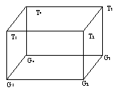
Fig 2. 3D object diagram
(1)Node defined
On the GIS, the spatial data are saved in SHAPE field and consisted of nodes. These nodes can record values of the X and Y coordinate, but cannot record Z coordinate. In general, the Z coordinate is stored on the attribute table. Therefore, we must create and define node structure and give the value of X, Y and Z coordinates into these nodes on all 3D Objects.
Define node structure:
Gi = {x,y,z|where x,y,z belong R}
Gi is represent the bottom node of 3D object
Hi = {0,0,h|where h belong }
Hi is represent 3D object's height value.
Ti = Ni + Hi
Ti is represent the top node of 3D object
(2)Face defined
When all nodes of the 3D object are defined completed, we starting to define the face of the 3D object. The face define can divided into there section:
Define the 3D object's bottom face:
Bottom = {G1,G2,G3,…,Gi}
Define the 3D object's top face:
Top = {T1,T2,T3,…,Ti}
Define the 3D object's edge face:
Edgej = {Gj,Gj+1,Tj+1,Tj}
For reduce complexity, we using four nodes to make a side face.
(3)3D Algorithm
When the nodes and faces are defined completed. Finally, we start to design the 3D algorithm.
begin
for i:=1 to nNode
LinkG(Gi,Gi+1)
LinkT(Ti,Ti+1)/
LinkS(Gj,Gj+1,Tj+1,Tj)
end
end
2. The solution of the attribute data problem
Because VRML cannot access data from Server's database directly. Therefore, we must apply other technology, such as ASP or CGI that can be access data form Server's database and to solve this problem.
This study will be saved the GIS attribute data on the Microsoft Access database and writing an ASP program to connect this database, and using VRML Anchor node to group of every 3D Object. By using Anchor's Field url, we can define link URL of the 3D Object. For example,
Anchor{
children Shape{ geometry Box{} }
url"http://wyku/vrml.asp?table=attribute&object=ObjectNo"
}
When user clicked the 3D Object, browser will be connecting to this URL. Because ASP is running on the Server, so we can query this Object's attribute data from server's database.
3. Automatic Translation Interface
In order to confirm the practicable of method with our research, we integrated our study result to program the Automatic Translation Interface(ATI), the ATI structure is as follows:
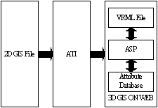
Fig 3. ATI structure
When 2D GIS File is improved into ATI, we can set translation area, the ATI will analyze nodes of all 2D object and translate into VRML format. In the same time with translation, ATI will be exported every 2D object's attribute data into database, and add a link on every 3D VRML object.
4.Example For testing ATI, we made of choice the first campus of Feng Chia University for our experiment. We imported the 2D campus file into ATI(see. Fig4) and the result is very perfect. ATI exported a VRML file that the size is only 50 KB and every building is independent.
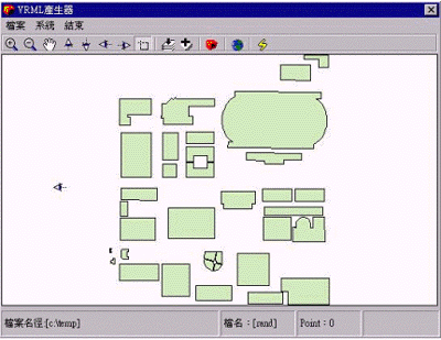
Fig 4. Fist campus in ATI
User can connect to our 3D GIS web site(http://rand.gis.fcu.edu.tw/3DGIS) to visit this VRML scene and query every building attribute data. This result proves our method of this study is practicable.
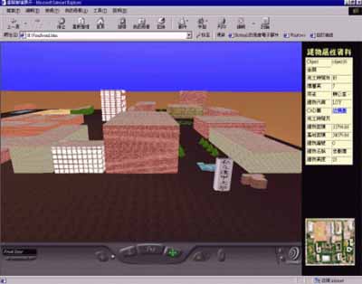
Fig 5. First campus VRML scene
V.Conclusion
This research resolve the bottleneck of 3D GIS on web, i.e. transfer 2D GIS data to VRML and keep their attribute data concurrently, this is just a beginning, and there are several problems should be discussed:
- It decreases the speed of browsing VRML scene when VRML scene has a large size, binary VRML format will be a good solution for decreasing the presently ASCII VRML format.
- How to query a spatial object not only by mouse click, but also by object attribute is next phase to research.
- The result shows the building objects by cube, i.e., the 3D shape of a building is based on its 2D shape, and extrude with its attribute related to its height, it's a simple way to display a spatial object, but also ignore the real figuration of itself, how to present a spatial object with its original figuration is worth to study in the field of 3D GIS on web.
- Bo Huang, Hui Lin,1999. GeoVR: a web-based tool for virtual reality presentation from 2D GIS data, Computers and Geosciences 2591999), p1167-p1175.