| GISdevelopment.net ---> AARS ---> ACRS 2000 ---> Forest Resources |
Modeling Landscape changes
using Logit Models
Li-Ta Hsu
Associate Professor, Department of Environmental Design
Hua Fan University
1 Huafan Rd., Shr-Ding, Taipei, 223
Tel: (886)-2-2663-2102 #4563 Fax: (886)-2-2663-2102 #4570
E-mail: lita@mail.ht.net.tw
TAIWAN
Chi-Chuan Cheng
Deputy Director
Yu-Ching Lai
Post Doctoral Researcher
Taiwan Forestry Research Institute
53 Nan Hai Rd., Taipei, 100
Tel: (886)-2-2303-9978 #1208 Fax: (886)-2-2375-4216
E-mail: cccheng@serv.tfri.gov.tw
TAIWAN
Key WordsAssociate Professor, Department of Environmental Design
Hua Fan University
1 Huafan Rd., Shr-Ding, Taipei, 223
Tel: (886)-2-2663-2102 #4563 Fax: (886)-2-2663-2102 #4570
E-mail: lita@mail.ht.net.tw
TAIWAN
Chi-Chuan Cheng
Deputy Director
Yu-Ching Lai
Post Doctoral Researcher
Taiwan Forestry Research Institute
53 Nan Hai Rd., Taipei, 100
Tel: (886)-2-2303-9978 #1208 Fax: (886)-2-2375-4216
E-mail: cccheng@serv.tfri.gov.tw
TAIWAN
Landscape changes, Logit models
Abstract
Detecting and monitoring landscape changes is an important issue of landscape ecology and ecosystem management. This study used two sets of aerial photographs taken in 1988 and 1996 to derive land cover maps of the Liukuei ecosystem management area. The two maps were compared to identify transitions among land cover types. GIS and logit models were used to examine the historic changes of the landscape, and to predict probabilities of landscape changes. Three kinds of explanatory variables, namely, environmental factors, spatial factors, and patch attributes, were examined. Environmental factors include elevations, slopes and aspects of the randomly selected places. Spatial factors include distances to roads, to streams, and to natural forests. Patch attributes include the sizes, perimeters, and shape indices of the patches where the samples were located. Maximum likelihood methods were used to estimate the parameters of binary and multinomial logit models. Results show that the most influential factors of landscape changes were elevations, slopes and distances to natural forests, whereas none of the patch attributes examined in the model were significant. In general, conifer and hardwood plantations located at lower elevations and near natural forests were more likely to become natural forests. Bare lands were more likely to occur on high elevation places near roads and with steep slopes. On the other hand, low elevation bare lands near natural forests and away from roads were more likely to be reclaimed by natural forests. These results can be used to project the probabilities of landscape changes spatially, and would be useful for guiding the management practices of the Liukuei ecosystem management area in the future.
1. Introduction
Landscape ecology studies the structure, function, and spatial pattern of landscapes (Forman and Godron 1986). In landscape ecology, landscape indices are often used to describe and analyze the landscape structure of a landscape. For examples, O'Neill et al. (1988), Li (1990), Turner (1990), Turner and Gardner (1991) used various landscape indices to quantify landscape structures. In analyzing landscape changes, regression models and Markov models are often used to analyze the distributional changes of a landscape at different points in time. For instances, Alig (1986) used regression models to analyze the acreage changes of a forest landscape, Burnham (1973), Lindsay and Dunn (1979), and Muller and Middleton (1994) applied Markov models to study landscape changes. Another kind of landscape models is the spatial models. Spatial models of landscape changes focus on the spatial characteristics of landscape changes such as factors contributing to landscape changes, or variations in probabilities of landscape changes at different locations (Baker 1989). Distributional models such as Markov models and regression models can be modified into spatial, for example, Turner (1987) applied Markov probabilities to simulate spatial landscape changes using pixels. However, he suggested that because Markov models are non-spatial in nature, the probability in each pixed should be adjusted according to the conditions of its neighboring pixels. Another commonly used probabilistic spatial models are the probit or logit models. The principles of probit or logit models are similar to those of regression models. They can be used to analyze factors contributing to landscape changes, and use the results to predict probabilities of landscape changes at different spatial locations. Dale et al. (1993) used multinomial logit models to analyze the spatial pattern of deforestation in Brazil. In studies of land use changes, McMillen (1989)and Hsu (1996) further integrated logit models with economic theories, and used them to explore the spatial pattern of land use change. In Taiwan, there are also several literatures about monitoring landscape patterns, for example, Lin (1996) used Markov models and ridge regression models to model vegetation changes in Tainan, and Hsu and Cheng (2000) applied Markov models of predict long-term trends of landscape change in an ecosystem management area. However, until now, none of the literature has used probit or logit models in analyzing spatial landscape changes.
This study is a part of a long-term monitoring program carried out in Liukuei ecosystem management area. In this study, digital photogrammetry was used to generate land cover maps of the Liukuei ecosystem management area in 1988 and 1996. Logit models were used to examine the relationships between landscape changes and environmental factors. The results can provide useful information for the planning, monitoring of the landscape in the future.
2. Material and Methods
The study area, 'Liukuei ecosystem management area', is a part of the Liukuei experimental forest of the Taiwan Forestry Research Institute. Located at Maolin Township, Kaohsiung County, the study area encompasses seven forest compartments, and covers about 2500 ha. Elevation in the area ranges from 300m to 1800m, and the topography is up-sloped from southwest to northeast. The Shanping post and several nurseries are also located inside the area and are connected by service roads stretching throughout the area. Natural forests dominate 78% of the landscape, and man-made stands occupy the remaining 22%. Most of the man-made stands are coniferous plantations. On the other hand, natural forests consist of various broadleaf tree species, and some are mixed with conifers. Parts of the natural and man-made forests have recently undergone timber harvesting and reforestation. Therefore, some cut areas exist. In addition, there are some nonforested areas such as grasslands or bare lands resulted from landslides.
Aerial photographs taken in 1988 and 1996 were used to generate land cover maps of the study area. Positive films of the photographs were scanned into digital images. With several ground truth measurements, the images were subsequently rectified as orthogonal images with accurate positioning. Image pairs were then displayed as stereographs on computer screens, where features on the landscape were delineated and digitized. As a result, two sets of land cover map files were created in vector format (Fig.1).
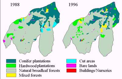
Fig. 1. Landscape changes at the Liukuei ecosystem area.
For each land cover patch, or polygon, its land cover type, area, and perimeter were recorded. The two maps were then overlaid together using a geographic information system to identify land cover changes during the time interval.
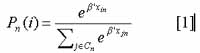
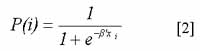
The purpose of this study is to develop a set of probabilistic models for predicting landscape changes spatially. Binomial and multinomial models were used to examine the factors contributing to landscape changes. Supposing the observed landscape changes were related to some exogenous factors x's, then, in multinomial logit models, the probability that a land cover type would become land cover type i , or Pn(i), can be written as:
Factors examined in this study can be classified into three categories: locational factors, environmental factors, and patch characteristics. Locational factors include distance to roads (TOROAD), distance to streams (TOSTREAM), distance to natural breadleaf forests (TONATURE). Environmental factors elevations (ELEVATION), slopes (SLOPE), and aspects (ASPECT). Patch characteristics include patch size (SIZE), perimeter (PERI), patch shape index (SHAPE) and soil type (SOIL). In order to estimate logit models, sample points were randomly selected from the land cover maps. For each sample point, landscape change from 1988 and 1996, its associated environmental factors, and characteristics of its associated patch were recorded. Parameters in equation [1] and equation [2] were estimated using maximum likelihood method. To obtain the final models, backward selection was used to eliminate the least correlated variables step by step until the t-statistics of all parameters were statistically significant at a =0.05.
Statistical significance of a logit model can be tested using likelihood ratio test statistics, which follow Chi-square distribution with k degrees of freedom (k = number of parameters been estimated). Alternatively, the likelihood ratio index, orp2 can be used to examine the goodness of fit of a model. The likelihood ratio index is similar to the determinant coefficient (R2) of a regression model. p2 = 1 when the model fits the observed data perfectly, and when p2 = 0, it means that the included variables do not explain the observation at all.
3. Results and Disscusions
This study focused on landscape changes under natural conditions (without human interference), therefore, man-made modification such as cutting tract reforestation, forest roads, buildings and nurseries were not included in the analysis. Observed landscape changes from 1988 to 1996 included the following: (1) from coniferous plantations to coniferous plantations, natural forests, or bare lands, (2) from hardwood plantations to hardwood plantations or natural forests, (3) from natural forests to natural forests or bare lands, (4) from mixed forests to mixed forests, natural forests, or bare lands, (5) from bare lands to bare lands or natural forests. Among them, coniferous plantations and mixed forests included more than two possible ways of landscape changes, and therefore multinomial logit models were applied. For other land cover types including hardwood plantations, natural forests, and bare lands, binary logit models were used because they had exactly two possible ways of landscape changes.
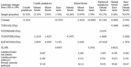
The results of model fitting were shown in Table 1. Among the explanatory variables, the effects of locational factors and some of the environmental factors such as elevations and slopes were more significant. On the other hand, patch characteristics and aspects were not significant. Table 1 showed that for all the logit models, nether likelihood ratio test statistics, nor likelihood ratio indices (p2) were statistically significant. This is mainly because the landscape changes only consisted of a fairly small portion of the landscape. As a result, the models tend to underestimate the probabilities of a land cover type converting to other land cover types. Therefore, it would be difficult to judge which land cover type would a place convert according to equation [1] and equation [2]. However, comparisons show that for places where landscape changes did occur, their associated probabilities of land cover changes is significantly higher than other places. That is, despite that the models tends to underestimate the probabilities of landscape changes, the relative magnitudes of probabilities can be used to identify areas where landscape changes are more likely to occur.
The effects of explanatory variables on landscape changes can be inferred from the signs and magnitudes of coefficients shown in Table 1. The results showed that changes from coniferous plantation to natural forests or mixed forests were related to distances to natural forests and elevations. The closer the distance to natural forests, and the lower the elevation, the likelier a coniferous plantation would turn into natural forests or mixed forests. On the other hand, the occurrences of bare lands were related to elevations and slopes. Bare lands were more likely to occur on coniferous plantations at high elevations and with steep slopes. For mixed forests, the closer they were to natural forests, the likelier they would turn into natural forests, and the higher the elevation, the likelier they would remain as mixed forests. Similar to coniferous plantations, bare lands were also more likely to occur on mixed forests at high elevations and with steep slopes. For hardwood plantations, the conversions to natural forests were related to distances to natural forests, elevations, as well as distances to streams. Low elevation hardwood plantations near natural forests were more likely to become natural forests, but if they were near to the streams, the trends became less obvious. As to natural forests, bare lands were more likely to occur on forests near the roads and with steep slopes. In contrast, low elevation bare lands farther away from roads, and near natural forests were more likely to be reclaimed by natural forests.
The logit models can be used to spatially predict the landscape changes. Taking coniferous plantation as an example, the observed and model predicted landscape changes were compared in Fig. 2. The figures showed that, though not perfect, the model predicted landscape changes match the observed landscape changes fairly well.
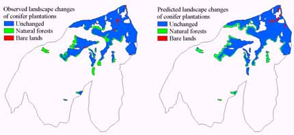
Fig. 2. Comparisons between the observed and model predicted landscape changes.
4. Conclusions
Several conclusions can be drawn from the results of this study:
- In analyzing factors contributing to landscape changes, topographic effects and edge effects appeared to be more influential than patch attributes. Whether a man-made plantation would turn into natural forests or not is largely determined by its distance to natural forests as well as its elevation. Whether a forested area would become bare lands or not depends on its slope. Factors that had the most significant effects included elevations, slopes, distances to natural forests, and distances to roads. On the other hand, bare lands with gentle slope and farther away from roads were more likely to recover into natural forests.
- Although logit models can be used to predict "what" land cover change would occur on a given place, but if the observed land cover changes only consist of a small portion of the landscape, the predicted probabilities of change will be under estimated. Therefore, it is not practical to use logit models for prediction in such cases. However, logit models are useful in comparing the relative likelihood of landscape change at different locations.
- In this study, factors affecting landscape change coincide with the a-priori expectation in general. One major advantage of logit models is that the extents of influences can be quantified and compared. Such comparisons can provide very useful information to decision maker in management planning.
- Baker, W. L., 1989. A review of models of landscape change. Landscape Ecology, 2(2), pp. 111-133.
- Burnham, B. O., 1973. Markov intertemporal land use simulation model. Southern Journal of Agricultural Economics, 5, pp. 253-8.
- Dale, V. H., O'Nell, R. V., Pedlowski, M., Southworth, F., 1993. Causes and effects of land-use change in central Rondônia, Brazil. Photogrametry Engineering & Remote Sensing, 59(6), pp. 997-1005.
- Forman, R. T. T. , Godron, M., 1986. Landscape ecology. (NY): John Wiley and Sons. 619 p.
- Hsu, L. T., 1996. Modeling land use change in human dominated landscapes: a case study of urbanization in an Indiana watershed [dissertation]. West Lafayette (IN): Purdue Univ. 255 p.
- Hsu, L. T. , Cheng, C. C., 1999. Assessing landscape change in Liukuei ecosystem area using Markov model. Taiwan Journal of Forest Science, 15(1), pp. 41-49.
- Li, H., 1990. Spatio-temporal pattern analysis of managed forest landscape: a simulation approach [dissertation]. Corvallis (OR): Oregon State Univ. 166 p.
- Lin, J. S., 1996. Study on the change detection of ecological environment by using the remotely sensed data on vegetation ecosystem: an illustration of Tainan district [dissertation]. National Taiwan University. 252 p. [in Chinese with English summary]
- Lindsay, B. E., Dunn, D. L., 1979. Land use projections under alternative policies: a transition matrix approach. J Northeastern Agricultural Economic Council 8(2), pp. 87-99.
- McMillen, D. P., 1989. An empirical model of urban fringe land use. Land Economy, 65(2), pp. 138-45.
- Muller, M. R., Middleton, J., 1994. A Markov model of land-use change dynamics in the Niagara Region, Ontario, Canada. Landscape Ecology, 9(2), pp.151-7.
- O'Neill, R. V., Krummel, J. R., Gardner, R. H., Sugihara, G., Jackson, B., DeAngelis, D.L., Milne, B.T., Turner, M.G., Zygmunt, B., Christenser, S. W., Dale, V. H., Graham, R. L., 1988. Indices of landscape pattern. Landscape Ecology, 1, pp.153-162.
- Turner, M. G., 1987. Spatial simulation landscape changes in Georgia: A comparison of 3 transition models. Landscape Ecology, 1(1), pp.29-36.
- Turner, M. G., 1990. Spatial and temporal analysis of landscape patterns. Landscape Ecology, 4, pp.21-30.
- Turner, M. G., Gardner, R. H., 1991. Quantitative methods in landscape ecology. Ecological Studies. Vol. 82. (NY): Springer-Verlag. 536 p.