| GISdevelopment.net ---> AARS ---> ACRS 2000 ---> Forest Resources |
Application of Ecosystem
Management Decision Support System in selecting suitable site for
Taiwania
Su-Fen WANG
(Taiwan)
Graduate student, Department of Forestry , National Taiwan University
Department of Forestry, National Taiwan University,106 Taipei, Taiwan
Telephone: +886-2-23638044 Facsimile: +886-2-23638044
E-mail: d7625009@ms.cc.ntu.edu.tw
Yeong-Kuan CHEN (Taiwan)
Professor , Department of Forestry , National Taiwan University
Department of Forestry, National Taiwan University,106 Taipei, Taiwan
Telephone: +886-2-23639799 Facsimile: +886-2-23639799
E-mail: ykchen@ccms.ntu.edu.tw
Chi-Chuan CHENG (Taiwan)
Deputy Director, Taiwan Forestry Research Institute
53, Nanhai Road, Taipei 100, Taiwan
Telephone: +886-2-23039978 Facsimile: +886-2-23757469
E-mail: cccheng@serv.tfri.gov.tw
Key WordsGraduate student, Department of Forestry , National Taiwan University
Department of Forestry, National Taiwan University,106 Taipei, Taiwan
Telephone: +886-2-23638044 Facsimile: +886-2-23638044
E-mail: d7625009@ms.cc.ntu.edu.tw
Yeong-Kuan CHEN (Taiwan)
Professor , Department of Forestry , National Taiwan University
Department of Forestry, National Taiwan University,106 Taipei, Taiwan
Telephone: +886-2-23639799 Facsimile: +886-2-23639799
E-mail: ykchen@ccms.ntu.edu.tw
Chi-Chuan CHENG (Taiwan)
Deputy Director, Taiwan Forestry Research Institute
53, Nanhai Road, Taipei 100, Taiwan
Telephone: +886-2-23039978 Facsimile: +886-2-23757469
E-mail: cccheng@serv.tfri.gov.tw
EMDS, ecosystem management, species determination
Abstract
Ecosystem management has become the mainstream of contemporary forestry. Ecosystem management involves a variety of different issues and is an adaptive management approach that is able to adapt to temporal changes in needs. Therefore, a computer is needed to process complex data, and to integrate knowledge of various disciplines in order to develop decision support system for use in decision making for forestry. EMDS (Ecosystem Management Decision Support) is a decision support system for ecosystem management developed by the USDA Forest Service. The system integrates knowledge-based ecological and geographic database with geographic information system to build a dynamic decision support system that allows the user to easily modify the size of study area and criteria for assessment. Taiwania (Taiwania cryptomerioides), distributed in mid-elevation areas, is one of the most important native coniferous species in Taiwan. This species is worthwhile planting because it grows well and rarely gets infected with disease. In this research, the Luikuei Experimental Forest was selected as the study site. Using the topographic and soil data, suitable sites for Taiwania were selected according to the fuzzy logic provided by the EMDS knowledge base. It is expected to improve the traditional map overlaying method, which has the drawback of being not objective when determining the levels for suitability analysis. The results will be used as reference for the forest managers to select tree species for plantation.
1. Introduction
The main job of forest ecosystem management is to make the forest resource well arranged and used. The ecosystem principles are applied to fit the objectives of economic and social needs. For managers, the process of resource arrangement and using involves a series of decision making. All kinds of decision support systems are being developed as the computer techniques continue to improve. The ecosystem researchers are trying to solve the dynamic and complex problems by computer simulation and analysis.
The purpose of ecosystem management is to maintain the diversity and sustainable development of forest resource. Forest ecosystem management is the guideline of the forest management in Taiwan now. According to the principle of sustainable management, forest land must be classified for multi-purposes such as economics, protection, and recreation. Long-rotation and deep-root species must be planted for the needs of watershed management.
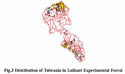
Taiwania (Taiwania cryptomerioides), distributed in mid-elevation areas, is one of the most important native coniferous species in Taiwan. This species is worthwhile planting because it grows well and rarely gets infected with disease. In this research, the Luikuei Experimental Forest was selected as the study site, and EMDS (Ecosystem Management Decision Support) was used as the tool to perform suitablility analysis for Taiwania. The result was compared with the real situation to evaluate the feasibility of the EMDS in suitablility analysis.
2. Materials and Methods
2.1 Study area, data, and tools
The Liukuei experimental forest of the Taiwan Forestry Research Institute was selected as the study area, which is located at Maolin, Kaohsiung County. The study area encompasses 25 forest compartments, and covers about 9616 ha. Average temperature is 16 to 23 degree Celsius, total annual rainfall is about 2150~3748 mm, and elevation is between 350~2400 km. Main forest type is natural broad-leaf forests, and there are coniferous and mixed-forests at high elevation.
The data used in this study are listed as the following:
- Soil data: The soil data were collected by the soil inventory team.
- DTM: The DTM data was obtained from the Agriculture and Forestry Aerial Survey Institute, with a pixel resolution of 40×40 meter. The slope map, aspect map were derived from the DTM data.
- Areial photographs: A 1/5000 scale forest type map was made from aerial photographs. Positive films of the photographs were scanned into digital images and the features of landscape were identified.
- The software used in this study were ArcView Version 3.1 and EMDS Version 2.0.
2.2 Analysis method
Topographic and soil characteristics are the main factors that influence the vegetation habitat. Topographic factors include the elevation, slope, and aspect. Elevation affects the temperature, aspect affects the insolation, and slope affects the washout and insolation of the habitat. In this research, elevation, slope, and aspect were grid-based, which were produced from the DTM. Each grid can be treated as a single unit, but it seems too small to characterize the concept of landscape scale for the ecosystem research. It took much more time to process data than using watershed unit. Grid unit is used only when it is specially required or the study area is small, and grid data must be converted to vector format and suitable unit must be selected.
First order watershed was selected as basic unit to establish the database of ecosystem. According to the results of previous researches, environmental factors related to Taiwania growth in different levels were selected to build the dependency network and data links. Data links are frequently used to represent data and evaluate their degrees of membership based on the concept of quantitative fuzzy argument. All the data are standardized to 1~-1, which is called truth-value. Where 1 means the environmental condition is completely suitable for the Taiwania; on the other hand, -1 means not suitable. This dichotomy is improved by fuzzy logic and compensation of ecological factor is better represented by fuzzy algorithm. For example, proper soil will compensate the weakness of topographic condition. This can't be shown in traditional overlay approach.
Taiwania is distributed between 1000~2000km in elevation in the Luikuei Experimental Forest, but grows better between 1200~1700km. According to the forest type inventory in the study area, the planting sites with better quality are listed as Table 1. It shows that the suitable slope for Taiwania is from 15 degree to 45 degree, but must be constrained under 35 degree when considering the working sites permissible. As for the aspect, though some references show Taiwania was distributed in South, the sunlight was compensated in this study area, because it's nearby tropical. Because Taiwania can be found in all the aspects, so the aspect factor was abandoned in this study.
| Forest compartment | Plantation area (ha.) | Elevation (m) | Aspect | Slope (degree) |
| 2 | 38.5 | 1500-1600 | North-West | 20-40 |
| 2 | 40 | 1500-1600 | North-West | 20-40 |
| 2 | 12.9 | 1000 | North-West | 20-40 |
| 3 | 58 | 1500-1600 | South-West | 20-30 |
| 3 | 20 | 1500 | South-East | 20-35 |
| 3 | 61.3 | 1300-1500 | South-West | 20-35 |
| 3 | 26.5 | 1400 | South-West | 20-35 |
| 10 | 24 | 1400 | South-East | 20-30 |
| 12 | 24.8 | 1450 | South-East | 20-30 |
| 12 | 25 | 1500 | South-East | 20-30 |
| 12 | 23.7 | 1300 | South-East | 20-30 |
| 12 | 18.5 | 1500 | North-East | 15-25 |
| 12 | 19.2 | 1500 | North-West | 15-30 |
| 12 | 15 | 1300 | North-West | 15-30 |
| 13 | 47.4 | 1500 | North-East | 20-40 |
| 13 | 24.1 | 1600 | North-West | 20-45 |
| 14 | 41.3 | 1500 | South-East | 25-40 |
Soil type determines soil characteristics such as texture, water drainage, and nutrient. Soil type was selected in this study, and soil inventory book was used as reference to select soil type. Soil types such as Fcs, Mls, Nsa, Nsa-Ycl, Stm, Wss, Ycl, Gts-Mls, Stm-Ycl, Wss-Ycl are with sandy-loam texture, well water drainage and suitable for planting, were selected.
3. Results
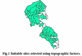
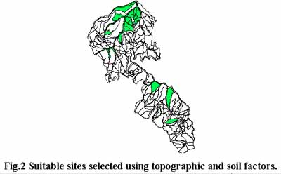
When topographic factors were considered, most of the study area were included in the result because the average values were used for first order watershed unit, and the values were too rough to determine the species (Fig. 1). Therefore, soil factors must be selected in species determination. From another perspective, the species determination is a local and small-scale forest management programming when considering scale, therefore the micro condition of habitat must be considered (soil, micro-climax…etc).
Though this study shows the value of EMDS in suitability analysis, there is still some problem with respect to the analysis units. The analysis units in the resulting map are complex, and the locations and boundaries are difficult to define in real world, which may cause the work difficult. The common units must be created in order to build the database for ecosystem decision support system.
First order watershed unit and soil unit were used because the choice of species is a type of small scale ecosystem management. For incorporating the ecological issues at different scales in EMDS, all the units must be converted to match the corresponding watershed unit, which is used as the basic unit.
5. Conclusion
The following conclusions can be drawn from this study:
- It is feasible to apply EMDS in species determination in Taiwan. As for large scale forest planning, more complex factors must be considered, and more perspectives such as economics, society, must be involved.
- Topographic factors are too rough to determinate the species, because the species determination is a local forest programming. Data scale must be selected carefully to match the study issues.
- Cheng, CC. ,1995. GIS application in forest land classification. Taiwan Journal of Forest Science, 10(2), pp. 241-54 [in Chinese with English summary].
- Densham, P.J. and M.F. Goodchild, 1989. Spatial decision support system : A research agenda. GIS/LIS Proceedings, Vol. 2. pp. 707-716.
- Herrington, L.P. and D.E. Koten,1988. A GIS based decision support system for forest management. GIS/LIS'88 Proceedings, Vol. 2. pp. 825-831.
- Jeng H. D., 1994. A Research on Spatial Decision Support System --Designing A System for Land Use Models Building Assistant Environment. [MSc thesis]. National Taiwan University, Taiwan. [in Chinese with English summary].
- Keith M.Reynolds, EMDS User's Guide (Version 2.0)
- Lai H.Y., 1995. DTM, GIS applications in planning water conservation protected forest [MSc thesis]. National Taiwan University, Taiwan. 131 p. [in Chinese with English summary]
- Meulen, G..G.., 1992. Geographical information and decision support system, Computer, Environment and Urban Systems, 1(16), pp. 187-193.
- Robert H.G. et al., 1987. Neutral models for the analysis of broad-scale landscape pattern. Landscape Ecology, 1(1), pp. 19-28.
- Salwasser H, and R.D. Pfister, 1994. Ecosystem management: from theory to practice. In: US Department of Agriculture, Forest Service, editor. Sustainable ecological systems: implementing an ecological approach to land management. Gen.Tech.RM-247, Rocky Mountain Forest and Range Experiment Station, 363 p.
- Shrestha,B.P. and Duckstein L., 1998. A Multiobjective Decision Support System Multiresource Forest Management. Group Decision and Negotiation, Vol.7. pp. 23-40.
- Sharpe, D.M. and Yang, Z., 1991. Design of buffer zones for conservation areas and a prototype spatial decision support system(SDSS). GIS/LIS'91 Proceedings, Vol. 1. pp. 60-70