| GISdevelopment.net ---> AARS ---> ACRS 2000 ---> Educational & Profession |
Telling Stories Of
Jin-Shan-Miann Adjacent To Hsinchu Science-Based Industrial Park On A
Simulated Rocsat-2 Image
Ku-Yu Chang
National Chu-Pei High School,
Hsinchu, Taiwan
Chih-Li Chang
Senior Researcher, National Space Program Office
8F, 9 Prosperity 1st Road Science-Based Industrial Park
Hsinchu, Taiwan, 300
Tel: 886-3-5784208 ext. 8461, Fax: 886-3-5799972
Email: CLChang@nspo.gov.tw
National Chu-Pei High School,
Hsinchu, Taiwan
Chih-Li Chang
Senior Researcher, National Space Program Office
8F, 9 Prosperity 1st Road Science-Based Industrial Park
Hsinchu, Taiwan, 300
Tel: 886-3-5784208 ext. 8461, Fax: 886-3-5799972
Email: CLChang@nspo.gov.tw
Key Words: ROCSAT-2, Space Image Simulation, Jin-Shan-Miann, Hsinchu Science-Based Industrial Park (SBIP)
Abstract:
Space images started civil uses since Landsat satellite was launched in 1972 and were mostly utilized by government agents. The civil uses were soon expanded to many fields of science, engineering and education; nevertheless personal use of the space image is the goal of the application for the remote sensing satellite. The paper describes a study of combining a space image and the stories of the spots on the image. Part of the paper was the result of the assignment of the history course. It demonstrates an excellent personal use of the space image.
The authors live in an area called Jin-Shan-Miann (JSM) adjacent to Hsinchu Science-Based Industrial Park (SBIP). The SBIP, nicknamed Taiwan's "Silicon Valley", is famous with semiconductor, PC computer, and related high-tech industries. Many famous worldwide companies are located there, such as, Taiwan Semiconductor Manufacturing Company (TSMC) and Acer Inc. On the other hand, the JSM was bright in the past but is faded now. The authors collected the stories and the image of the spots of JSM and tried to connect the old history and true spots with a simulated ROCSAT-2 image. The five stories were collected about JSM including Jin-Shan Temple, Kang-Lun Temple, Cool Water Stream, Huangs' House, and the oldest tree of Hsinchu City. The area of interest was selected and cut out from an air-borne image. The resolution is re-sampled in two-meter to generate an ROCSAT-2 image that will be available in late 2003. Furthermore, the simulated image was value-added with overlapping, marking and annotating. Since the space image provides plenty of information of the spots and the connections between those. It is then an excellent medium in the near future for students or the public to recognize and familiarize the area where he or she lives.
1. Introduction
Space images started civil uses since Landsat satellite was launched in 1972 and were mostly utilized by government agents. The space images take advantages of continuous archive of long history, global coverage, latest timing, and wide size. The civil uses were soon expanded to many fields of science, engineering and education; nevertheless personal use of the space image is the goal of the application for the remote sensing satellite.
Taiwan started the applications of the space image since 1974 and receiving space images from space in 1994. For educational applications in Taiwan, some SPOT images were collected to introduce the landscapes of Taiwan by professors and journalists (Wang 1998c). A junior high school teacher used SPOT images as supplementary materials in her earth science class (Kueng, 1998c). The user community grew up very fast over the recent years. Consequently, National Space Program Office, the official space organization of Taiwan, proposed a space imaging satellite in 1997. A pilot project, called "Investigation on the Requirements and Applications of Remote Sensing Satellite", was carried on during September 1997 and February 1998 (ERL/ITRI 1998a). The requirements were surveyed among the local users for the first baseline of user needs. After intensive discussion, the system requirements were finalized and filed in the Request for Proposal for an open bid. Matra Marconi Space (Astrium) won the spacecraft, a satellite without the science payload, in 1999 after bid competition. The satellite development passed the system design review in March 2000 and preliminary design review in June 2000. The satellite is scheduled to launch in 2003. The main characteristics of the satellite are as shown in Table 1.
| Panchromatic | Multispectral | |
| Mission | ||
| Altitude | 891 km | |
| Spectral Bands | One Panchromatic Band | Four bands: B1, B2, B3, B4 |
| GSD | 2 m @ Nadir | 8m @ Nadir |
| Swath width | 24 km @ Nadir | |
| Registration | After on-ground processing | |
| SL pointing capability | Roll & Pitch +/- 45° | |
| Optical Sub-Assembly | ||
| Focal length | 2896 mm | |
| Pupil Diameter | 600 mm - F/N = 4.83 | |
| Type | Cassegrain type with refractive Corrector | |
| Focal Plane Assembly | ||
| CCD | TH 7834 | THX 31547Quad-linear CCD |
| Integration Time | 0.308 ms | 1.232 ms |
| Processing rate | 10 Mpixels/s | 5 Mpixels/s |
| Data Processing | ||
| Pixel encoding | 12 bits (*) | 12 bits (*) |
| Compression ratio | 2.8 & 3.8 | 1.7 & 3.8 |
(*) 8 bits are selected after encoding.
Table 1: Some specifications of ROCSAT-2 remote sensing satellite in the preliminary design phase (Astrium, 2000a)
2. Jin-Shan-Miann
The Jin-Shan-Miann area is a community area rather than an administrative area. The Jin-Shan Temple is in the center of the area. It includes a big part of the present Hsinchu City and Hsinchu County. Most of the residences in this area are Hakkaness. T here are lots of historic sites in this little area, and five of them will be introduced later in this article.
3. Rocsat-2 Simulated Image
To simulate an ROCSAT-2 image with two-meter resolution, one can find two sources with finer resolution, such as Ikonos and aerial images. The aerial photos have been used for estimation of rice production and inventory of rice parcels regularly. The aerial image can be selected for any place in Taiwan and digitized from the aerial photo. There are several sets of aerial photos of whole Taiwan for the different time. On the other hand, the total coverage of the Ikonos image is limited in the existing archive for Ikonos was launched into the mission orbit last year. But, Ikonos is available for ordering a new imaging task of a specified area. The cost is cheaper for an aerial image than Ikonos. Because the aerial image of the Jin-Shan-Miann is available in the existing archive and the copied were widely used here; it serves as the source for the ROCSAT-2 simulated image. A digitized file of the aerial photo of the target, taken in 1993, was selected. Thanks to some powerful tools, the interest of region were re-sized and the resolution was re-sampled in two meters. The interested spots were properly identified, marked and annotated on the image.
When you go to the spot marked on the simulated image, you may have some difficulty recognizing it. Because the space or aerial image is viewed from top and the image may be too old to match the latest land use. The new picture of the real scene is helpful for the visitor. To take the best shot of the spots, the authors visited the spots and took pictures of them again. Each digital picture was overlapped on the simulated ROCSAT-2 image near the mark of the spot. Finally, some main roads, landmarks and scale were annotated in the simulated image to complete a tourism map. The simulated image is shown as Figure 1.
The first four spots are very closed each other in a simulated image covering area about 1.5 square kilometers. The fifth spot is far away from them and does not shown in the image.
4. Stories Of Five Spots
The authors live in an area called Jin-Shan-Miann (JSM) adjacent to Hsinchu Science-Based Industrial Park (SBIP). The SBIP, nicknamed Taiwan's "Silicon Valley", is famous with semiconductor, PC computer, and related high-tech industries. Many famous worldwide companies are located there, such as, Taiwan Semiconductor Manufacturing Company (TSMC) and Acer Inc. On the other hand, the JSM was bright in the past but is faded now. The authors collected the stories and the image of the spots of JSM.
First let's take a look at the two hundred-year-old Jin-Shan Temple (translation: Golden Hill Temple), because of it's old history, the temple went through many wars and historical events, yet it survived. Worshipers come from everywhere to worship the temple and ask for blessings (Chang 2000b).
Heritages of the temple reveal the evidences of the historical events that happened to the temple and even to the city. For example, on one of the octagon limestone pillar outside the temple is a little blob of concrete. Underneath the concrete is a bullet hole, which was caused during a battle between the Taiwanese and Japanese about a hundred years ago. Unfortunately a few years ago, the unique hole was sealed with concrete by the staff of the temple without valuing its historical significance. As years passed, many other historical heritages were also destroyed. Including the original clay shaped Buddha, which was brought to Taiwan from China about 150 years ago. For unknown reasons, in 1996 the temple threw the Buddha into the Do-Jan Stream. Taking its place is a wood carved Buddha which we see today.
During the war the Jin-Shan Temple served not only as a shelter to people' s soul but also their body, which lead to being burned by the Japanese. So most of what we see now is from reconstruction after the war and modification in 1985. Even then, there is still a lot of historic value in it, worthwhile for us to learn about.
The next site is a little temple unnoticed by many people because of its size and location. The little Kang-Lun Temple is located on a little hilltop embraced by two two hundred-year-old trees, one on each side. Don't underestimate this little temple, it was once the landmark of Jin-Shan area, because back then it could be seen by the naked eye from 20 km far away. Now high buildings block the view, yet the little temple carries on its job of protecting the residences nearby.
The third site is a stream named Cool Water Stream. The spring water that runs in it was sweet and pure, and it was once called the "Spiritual Springs ", many poets were attracted to come and wrote poems while drinking tea made with the water. So there are quite a few literature works about Cool Water Stream. But in 1980 SBIP used the water from the stream to fill a man made lake called Jin-Shin Lake, and what' s left of the stream was turned into the SBIP's industrial ditch. How pathetic! A once poetic stream now sacrificed to being the industries' ditch.
Although the source of the Cool Water Stream is difficult to identify now, the outlet from Jinq-Shin Lake is located at the north of the lake. The stream is beside the first part of Lane 525 of Section 1 of Guang-Fuh Road, intersects with the Guang-Fuh Road, and flows continually northward.
The next site is a seventy-year old house, this is where the Huangs live, and it is called the Huangs' House, located at 15 Lane 335, Section 1, Guang-Fuh Road. The Huang family was famous in Hsin-chu for its Hsin-Fu-Hsing pottery factory. At that time, it mainly produced red tiles, red bricks, jars, urns, basins and tombstones. Hsin-Fu-Hsing's red tiles and red bricks were the best construction materials in the entire Hsinchu area. Back then, most houses in Chin-Shan-Mien and the surrounding areas used Hsin-Fu-Hsing's products for their roof, floor and wall. The roof tiles used on the Huangs' House are red tiles from Hsin-Fu-Hsing. Even after several decades, their colors are still bright and have almost no visible green moss.
Across the road from the Huang House is a sixty-nine years old sandalwood tree, it was planted when their first grandson was born. That elder grandson who still lives in the Huang House is also sixty-nine years old now. So this sight is named Huangs' House and sandalwood tree.
Last, but not least is another old tree. This camphor tree is now three hundred years old as shown in the Figure 2. It is said that the hillsides of Jan-Shan Mean was once almost covered by camphor trees, but after years of over development this is the only camphor tree left from the past. The tree is 25 meters tall and can be surrounded by three people' s arms open! This is the oldest tree in all of Hsin-chu City!
The Taiwan High Speed Rail was originally planned to go over the old tree, so it had to be cut down. Many residences objected, and signed a petition to save the tree. This petition aroused the attention of the president of Taiwan High Speed Rail, Miss Ji In, and she decided to change the plan in order to protect this priceless old tree. All of the Jin-Shan Miann residents really appreciate the decision.
5. Conclusions
The applications of the space image are versatile. This paper shows a personal application of the remote sensing satellite. The five stories were collected about JSM including Jin-Shan Temple, Kang-Lun Temple, Cool Water Stream, Huangs' House, and the oldest tree of Hsin-chu City for a school assignment. The area of interest was selected and cut out from an air-borne image. The resolution is re-sampled in two-meter to generate an ROCSAT-2 image that will be available in late 2003. Furthermore, the simulated image was value-added with overlapping, marking and annotating. Since the space image provides plenty of information of the spots and the connections between those. It is then an excellent medium in the near future for students or the public to recognize and familiarize the area where they live.
References
Astrium, May 2000a, Remote Sensing Instrument Design Report, NSPO-CDRL-021a, p.9
Chang, K. Y., 2000b, Assignment Report (in Chinese): National Chu-Pei High School, Chu-Pei City
ERL/ITRI, 1998a, Investigation on the requirements and application of remote sensing satellite (Final Report), Report no: 06-3-87-W007
Kueng, H. M., 1998b, An Application of Satellite Remote Sensing Image In Junior High Education, paper presented at The Seventh Resource Satellite Application Conference, National Central University, Chung-Li
Wang, S., 1998c. Looking at Taiwan (in Chinese). Da-di publication company, Taipei
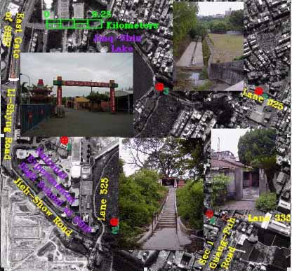
Figure 1: ROCSAT-2 Simulated Image of Jin-Shan-Miann Adjacent to SBIP
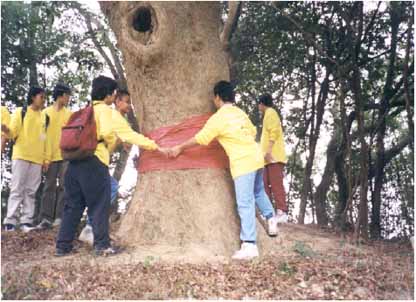
Figure 2: The oldest tree of the Hsinchu City