| GISdevelopment.net ---> AARS ---> ACRS 2000 ---> Educational & Profession |
" Survey Department of Nepal
: today and tomorrow "
Krishna Raj
Adhikary
Survey Department
Nepal
Survey Department
Nepal
Abstract
Survey Department of Nepal is a government agency under the Ministry of Land Reform and Management. Originating from 1957, the mission of Survey Department is to give support for creating and efficient and sustainable use of Land Information including maps and related product documents. Changing in society and changing in technology affects us all, we need to anticipate and plan for change in the needs of those who depend upon our land information, maps with related product document and services. To meet the user needs, attempts have been made to have resources for development of new products and services by introducing the new technology like GPS and digital system in some of the surveying and mapping activities including Geographical/Land information system.
1. Twenty five years in retrospective
Understanding change in surveying and mapping activities requires interpretation of the present in terms of the past. Knowing change in the past will prepare us for the future.
In Nepal, the history of surveying and mapping activities excluding cadastral survey is not so long. Surveying and mapping activities up to 1970's AD was mainly concentrated on the preparation of cadastral maps and related documents. They are prepared as an island map without the use of national geodetic controls. The purpose of preparing total land holding and the collection of revenue according to the types and areas of the holdings.
The Geodetic Survey and Topographical Survey in Nepal was established during 1970's. The initiation to define the spheroid with projection system and the national datum of the country was taken during those period. Earlier the system of map projection and preparation of topographical maps were all done with the help of Survey of India through Colombo Plan agreement. The ground control system were prepared by extrapolating the trigonometric control network system of India and adjacent countries.
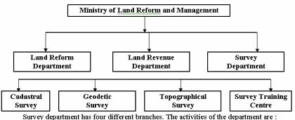
Survey Department was established, as a department status of the His Majesty's Government of Nepal, on 1975 AD. Topographical Survey, Geodetic Survey, Cadastral Survey and Survey Training Centre are the main branches of the department. Looking at the state of surveying and mapping, aviaries function were carried out by the different branches of the Department during past twenty five years.
What are the major changes on the field of surveying and mapping activities during past twenty five years of time ? There are a number of specific development which are changing the faces of Survey Department.
- Cadastral Survey :
- Establishment of napigoswara and preparation of cadastral maps/documents in national level 1964 AD.
- Completion of a series of cadastral maps of cultivated areas for all the seventy five district of Nepal.
- Geodetic Survey :
- Establishment of Geodetic survey 1971 AD.
- Establishment of higher and lower order national Geodetic control network.
- Establishment of lower order national levelling net work.
- Establishment of observatory tower, base stations, gravity station and laplace station.
- Survey Training :
- Establishment of Survey training centre 1969 AD.
- Production of different level of survey technicians (Basic, junior and supervisory level).
- Updating knowledge on surveying and mapping techniques for working surveyors by refresher courses on various subjects.
- Topographic Survey :
- Establishment of topographical survey 1976 AD.
- Establishment of aerial survey lab, installation of photogrammetry, cartography and printing equipments.
- Preparation of aerial photos of whole kingdom of Nepal (1979 and 1992 AD) at 1:50,000 scale.
- Preparation of Land use maps (at 1:50000 scale) and subsequent report of whole kingdom of Nepal 1980 AD.
- Preparation of topographic base maps (1:25000 and 1:50000 scale) of whole kingdom of Nepal except some portion of north western region of Nepal.
- Preparation of Nepal China International boundary maps (1979 AD).
- Preparation of large scale maps of specific regions of the country.
The survey department is one of the three departments of the ministry of Land Reform and Management.
- Establishment of national network of horizontal and vertical control points.
- Prepare and update topographic base maps and other types of maps.
- Prepare and update topographic base maps and other types of maps.
- Human resource development in the field of surveying and mapping.
- To conduct and monitor the surveying and mapping activities of the
country.
Geodetic Survey Branch of Survey Department has different sub-branches e.g. Trigonometrical gravity, GPS, Astronomical, Levelling and Survey Computation.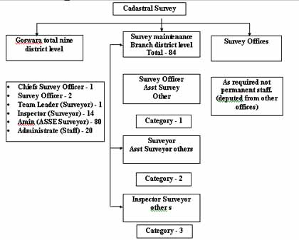
Similarly, topographical survey has the following sub-branches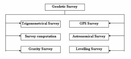
Photogrammetry, Field survey, Cartography, Printing, Boarder survey, and Integrated survey.
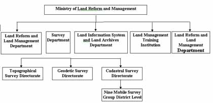
The proposal is to merge survey maintenance offices of Survey Department and district Land Revenue offices in one office. Survey Training Centre will act as Land Management Training Institution under the Ministry with the departmental status.
Land information system and Land archives department will newly be established in order to have an integrated Land information system with central level archived. The name of the Land revenue department will be changed as Land reform and Land management department after merging Land reform department into Land revenue department.
3. Technical development
Today surveyors are familiar with a new generation of surveying equipment and techniques. Traditional system of surveying and mapping has been replaced to semi-modern or modern techniques who can be characterised as "black box technology"
Giving results in real time and in digital form. Many of the surveying activities including field operation have been using "Push of Bottom" System with limited use of knowledge and experiences of the survey professionals. This technical evolution in our profession has influenced the instrumentation and techniques used in surveying and mapping. In Nepal, plane table surveying for cadastral survey is still popular. More than 2000 surveyors are still working on this technology. However, topographical surveying is carried out using aerial photos with photogrammetric analogue plotter and Geodetic surveying is still using triangulation traversing by theodolite and distance meter. Higher order geodetic controls and precision levelling works is carried out by precise theodolite and levels.
Attempts, to automate and make the surveying and mapping process more efficient, have also been going on for considerable time e.g. the use of digital mapping on cadastral, GPS methods for control points determination and use of computers for geographic land information system etc.
GPS methods for control points
Global positioning system (GPS) was used in the production of topographical base map on the Eastern Nepal Topographical base maps at 1:25 000 scale in the plane and 1:50 000 scale at the mountain. The aerial photography was taken with the help of kinematics GPS techniques in order to have the minimum control for the aerial triangulation singular on an unaccusable Himalayas part of the country. Similarly, the same method was used for the Western Nepal Topographical Mapping Project.
The extension of ground control for large scale cadastral maps is also carried out by GPS methods.
National topographic data base
The utilisation of digital geographic information has been growing fast in all sectors of the society of the world. Also, in Nepal this has given a great influence to the different organisations as well as in some of the sector of society. Recently, survey department has already prepared the specifications for geographic information service and national topographic data base in order to ensure the homogeneous quality and availability of needed geographic information with this national data base standard. Survey department runs its digital mapping applications on environment. Survey department is utilising cadcore/Tracer software for on-screen vectorsing and ARC/ Info as their editing and map use software. ARC/Info data base is used as data storage format. Digital geographic information is also used in producing graphic maps. The objective of the product specification is to ensure the sufficient information content for the user and the specification for topographic maps in scale 1:25 000 and 1:50 000 are aiming to fulfil the needs of users, as most updated maps of most of the regions of the country is easily available.
Reference
- Specification for Geographic Information Service and National Topographic Database Survey Department, June, 1999.
- National Mapping Issues and Strategies Survey Department, July, 2000
- Introduction to Survey Department A Report