| GISdevelopment.net ---> AARS ---> ACRS 2000 ---> Digital Photogrammetry |
Topographic Map Revision in
Digital Photogrammetric Environment
K.S.K.Wijayawardana
Assistant Superintendent of Surveys
Photogrammetric Unit, Survey Department
P.O.Box. 506,Narahenpita, Sri Lanka
Tel: -94-1-588871, Fax: -94-1-585586,
Email: sgsurv@sri.lanka.net
AbstractAssistant Superintendent of Surveys
Photogrammetric Unit, Survey Department
P.O.Box. 506,Narahenpita, Sri Lanka
Tel: -94-1-588871, Fax: -94-1-585586,
Email: sgsurv@sri.lanka.net
The Survey Department being the national surveying & mapping organisation that provides geo-spatial data to other institutions and individuals for their needs. During the period of 1980-1997, produced 1:50,000 topographical maps for the entire island under as an interim series. Since 1992, 1:10,000 topographic map series has been produced using photogrammetric method. Data available in digital form for all areas to be developed.
This paper describes updating of 1:10,000 map series using digital photogrammetric method. Now department is enriched with 2000dpi scanner and sophisticated software like VirtuZo for softcopy photogrammetry. Digital photogrammetric techniques may introduce or strengthen image-handling procedures such as orthophoto mapping. In this connection new concept was applied to revise the 1:10,000 map series namely the prioritised revision method (revision promptly by factors other than mere change in the landscape as a example of demanding from the customer or knowledge of future development) is used for this purpose.
Orthophotos can play vital role in such a revision as they show the terrain in fine detail. Digital photogrammetric techniques can be used to produce high quality, orthorectified aerial photographs quickly, easily and cheaply. Recently taken vertical photographs at a nominal scale of 1:20,000 available for scanning at a resolution of 25 microns. Interior orientation performed using camera calibration file for relevant year and fiducial marks for each scanned photograph. It is normal to relate the model created to a real world. So, it is necessary to have a number of ground control points, which can be identified in the model. Almost 80% of ground control points of already mapped area were in Microsoft access database. Once produced orthophoto(which can be mosaic for large area) after digital elevation model, then the existing vector data which to be revised can be overlaid on top of the orthophoto. Then new and changed information can be extracted by on screen digitising in Microstation environment.
Such a system will address the concern of the planners for decision making and customers for quality up to date data.
Introduction
Survey Department being the national surveying & mapping organization that provides topographical data to other institutions and individuals for their needs. This data are available in both hard copy and soft copy format. The history of topographic map production goes back to early 1900's. At that time department had established geodetic triangulation network and then the entire country was mapped using plane table method at the scale of one inch to one mile, this is popularly known as One inch map series. During the period of 1980 - 1997 Department has produced 1: 50,000 topographical maps for entire country by combining these one inch maps and 1: 40,000 aerial photographs. Since 1992 topographical maps of 1: 10,000 scale has been produced using 1:20,000 aerial photographs that were taken at early 90's. It implies that most of the available data do not provide updated or recent changes in development. The negative effects of delaying updating have been clearly demonstrated in planning and decision making stage. Updating of topographical maps in traditional way would take long period of time as well as money. As users are more concerned about updated 1:10,000 data, this paper describes updating of 1:10,000 map series using digital photogrammetric method.
Target area
The target area, Horana is situated in the Kalutara District of Western Province of Sri Lanka. Its geographical location is latitude 60 41' 34" & 60 43' 10" and longitude 800 02' 53" & 800 05' 03" and that covers 16km2. Area has been rapidly developed recently as introducing a new industrial zone. Simultaneously other facilities have been developed such as residential areas, commercial areas and new rods etc. In this connection necessity of revision of existing information is very vital.
Data and software/hardware used
Digital vector data set in particular area that was extracted in 1994 as per 1: 10000 data library. Recently taken aerial photographs with a scale of 1: 20,000 for scanning. Sophisticated software such as Vexcel, VirtuZo and MicrostationSE to photographs scanning, orthophoto generation and data extraction respectively. Data collection and analyzing were done by using soft copy photogrammetric instrument with 750MHZ 512MB RAM computer system.
Methodology
Workflow is as follows,
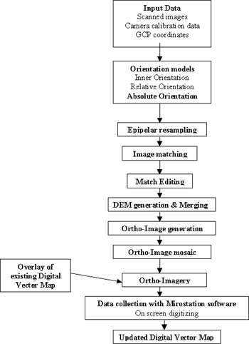
The first step in the map revision process was selecting most recent 1:20,000 scaled aerial photographs for scanning (no matter whether these are diapositives or contacts). Target area was covered two strips with six aerial photographs. All these were scanned 25 micron resolution with sophisticated VX 400 scanner. The scanning surface should be clean and dirt free to produce good quality images. With changing the look up table for each image, output image quality can be improved dramatically. It is important to have all fiducial marks in image for inner orientation. The next phase is to input scanned images and parameters such as camera calibration data and ground control points' coordinates to VirtuZo NT Workstation for further processing.
Next phase is to orient each model. The interior orientation is based on the calibration values and the measured coordinates of the fiducial marks. After completing the inner orientation of a model relative orientation can be performed continuously to obtain the stereoscopic vision. Then performed absolute orientation to transform the stereo model from photogrammetric coordinate system to ground coordinate system.
Once the relative orientation completed, can be specified the working area and do the automatic epipolar resampling to removed the Y- parallaxes from the original imagery. After creating epipolar image, software provides facility to do image matching automatically. The image matching method technique using to VirtuZoNT is an area and feature based, bridge mode technique integrating with the dynamic programming and least squares matching algorithms. As the image matching finished, can be entered editing environment. Software provides variety of editing tools for editing where necessary. Selecting options namely PRODUCT - DEM & ORTHO IMAGE provides by the software, Ortho Imagery can be created for each model. After creating a number of ortho images within a block, single continuous composite image for entire target area can be performed.
Then overlaid the existing vector data on to the composite ortho image. There is an interface between VirtuZo and Microstation software. In this connection, setting lower left & upper right coordinates of vector data set on to an ortho image, overlaid image can be get easily. After that digitizing performed on screen in Microststation environment as per 1: 10,000 data library. Separate level was assigned for new and changed information. Ultimately updated digital vector map available in acceptable accuracy.
Discussion
The 1:10,000 map revision method, which has been adopted by the Survey Department, would take at least one month to revise the particular target area. Even if we spent large amount of money for instrumentation, as a long time basis it would be benefited a lot because it will take only a few days to revise a map. Total time taken to produce ortho image and map revision for target area was three working days with the full time involvement of one person.
In future, revision of 1:10,000 map series in the Survey Department should be as mentioned earlier also target areas be selected according to the prioritized method (revision promptly by factors other than mere change in the landscape as a example of demanding from the customer or knowledge of future development). With regard to developing countries such as Sri Lanka, this system is very suitable because no need to spend much money for hardware/software maintain as well as no need of skill full persons to operate. Eventually, emphasis of developing such a system is benefited country a lot.
Conclusion
This paper is mainly dealt with revision of 1:10,000 map series in digital photogrammetric environment. Map revision is only one product from ortho imagery. As ortho imagery contains all terrain features in details, they can play vital role in land resources survey than conventional old paper maps. Further to map revision ortho images can be used as invaluable large information for earth resource planners as well as geological information system (GIS).