| GISdevelopment.net ---> AARS ---> ACRS 2000 ---> Digital Photogrammetry |
Extraction and Utilization of
Geometrical and Contextual Information in very High Resolution IKONOS
Satellite Imagery
Annie HUI, Soo Chin LIEW,
Leong Keong KWOH, and Hock LIM
Centre for Remote Imaging, Sensing and Processing, National University of Singapore Blk. SOC1 Level 2, Lower Kent Ridge Road, Singapore 119260 Tel: (65) 8746557 Fax: (65) 7757717 Email: crshuia@nus.edu.sg
Key WordsCentre for Remote Imaging, Sensing and Processing, National University of Singapore Blk. SOC1 Level 2, Lower Kent Ridge Road, Singapore 119260 Tel: (65) 8746557 Fax: (65) 7757717 Email: crshuia@nus.edu.sg
IKONOS satellite, very high resolution imagery, plantations, linear features, building height
Abstract
With the successful launch of the IKONOS satellite, very high resolution imagery (up to 1-m resolution) is within the reach of civilian users. In the one-meter spatial resolution images acquired by the IKONOS satellite, details of buildings, shadows, roads, vehicles, individual trees, and even aggregates of people are visible. The visibility of such details opens up many new applications which require the use of contextual and geometrical information contained in the images. In this paper, we present some examples where geometrical and contextual information are used. These examples include estimating building height from its shadow, automatic delineation of tree crowns for enumerating trees in oil palm plantations, and extraction of linear features for cartographic applications.
1. Introduction
Very high resolution imagery (up to 1-m resolution) is within the reach of civilian users with the successful launch of the IKONOS-2 satellite in September 24, 1999. The IKONOS satellite provides imagery at two resolution modes: a 1-m panchromatic mode and a 4-m multispectral mode with four (red, green, blue and near infrared) spectral bands. Images of a same area can be acquired simultaneously in the two resolution modes and merged to form a pan-sharpened natural colour image at 1-m resolution.
Many details such as building structures, roads, vehicles, individual tree crowns, and even aggregates of people can be seen clearly in the very-high resolution imagery. Pixel-based methods of image analysis will not work successfully in such imagery. In order to fully exploit the information contained in the imagery, image processing and analysis algorithms utilising the textural, contextual and geometrical properties are required. Such algorithms make use of the relationship between neighbouring pixels for information extraction. Incorporation of a-priori information is sometimes required. A multi-resolutional approach is also a useful strategy when dealing with very high resolution imagery. In this case, pixel-based method can be used in the lower resolution mode and merged with the contextual and textural method at higher resolutions.
In this paper, we examine three examples where contextual and geometrical information are used in extracting information from 1-m resolution IKONOS images: automatic delineation and counting of tree crowns in an oil palm plantation, road extraction in an urban area and estimating building height from shadow.
2. Tree Counting in Oil Palm Plantations
Oil palm plantation owners have a genuine interest in knowing the number of trees in their plantations for the fact that they need to monitor the production and to assess the value of the plantations. In the buying and selling of plantations, the interested parties evaluate a plantation not only by its size, but also by the quantity of palms within because knowing the actual number of trees will give them a better assessment of the production rate.
Oil palm plantations range in size from below 40 hectares to as large as 75,000 hectares. The current practice of tree census is to deploy workers into the plantations and count the palm trees manually. The cost of manual counting can be low but the accuracy is doubtful due to various human factors. Though going physically into a plantation to count trees is not a drudgery, it is extremely tedious and hard to verify. The availability of 1-meter resolution IKONOS satellite imagery provides a better alternative. The advantages are both in the bird-eye views it offers and in the convenience of working with digital imagery.
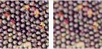
Figure 1 (Left) the appearance of oil palm trees in an IKONOS image, (right) the image after smoothing
The resolution of the IKONOS images is high enough for individual trees to be clearly spotted and enumerated. In these images of young plantations, palm trees generally have dome-shaped intensity profiles after some smoothing. Young trees tend to be well delineated at this resolution because of their distances of separation. As the trees grow bigger, the gaps among individual trees decrease and eventually disappear. However, the dome-shaped profiles remain visible. See Figure 1(a) for a palm tree image and Figure 1(b) for the image after smoothing.
Counting trees in an image is much more manageable as workers can label the trees easily on the image. Verification is much easier. To further reduce the tediousness of the task and to speed it up, tree counting can actually be automated and the human worker needs only to verify the counting and make minor corrections when necessary. There are existing image processing techniques, which can be easily adopted and modified to automate tree counting. One technique which shows excellent results is that adopted from Brandtberg and Walter (1998). This technique is based on the concepts of edge and curvature in differential geometry. The boundaries of the dome-shaped intensity profiles show up as edge segments. The curvature primal sketch is then used to integrate (1) the information from the edge segments detected at a particular resolution, and, (2) the information obtained at various resolutions. The curvature primal sketches obtained at various resolutions are summed together to form a cumulative primal sketch. Peaks in the cumulative primal sketch are filtered using a local maximum filter of the size of a palm tree. Those peaks that pass the filtering are considered to represent trees. The shortcoming of this technique is that it uses only the gradient of intensity and ignores the magnitude of intensity itself. Sometimes, the magnitude of intensity can be a useful piece of information. For instance, tracks and lanes in plantations tend to appear very bright in the image. Such areas can be filtered away by thresholding.
We have tested the performance of this technique with several scenes of the pan-sharpened 3-2-1 bands of the IKONOS images. Though the images are in RGB colours, at this stage we only use the red band. The intermediate result of one of them is presented in Figure 2. The original scene image is 400 pixels by 400 pixels in size. Figure 2 covers a zoomed-in area. The performance of this technique is verified with human eyes, which spotted 1803 trees in this region. With this technique, 1855 trees are counted by the automatic procedure. The accuracy of the technique is evaluated by the equation:
Accuracy = 1 - |no. of trees automatically counted - actual no. of trees| / actual no. of trees
Using this equation, the accuracy of automatic counting is 97.2%. Of the 1855 trees detected by the algorithm, 1535 are located correctly at the crown centers, 320 are mistaken as trees, and 268 trees are missed. We found that the errors are mainly due to the mis-location of the tree crowns. Instead of locating the trees at the centre of the tree crowns (which can be detected visually) the detected tree locations are displaced away from the crown centres. Hence, an error in mis-location contributes to both the mistaken tree and missing tree errors when validated by a human observer. There are four other scenes tested with this technique. There results are tabulated in Table 1.

Table 1 Performance of the tree counting technique
| Scene | Number of trees counted visually | Number of trees counted automatically | Counting accuracy (%) | Correctly spotted by the technique | Wrongly spotted by the technique | Missed by the technique |
| 1 | 1012 | 1018 | 99.4 | 928 | 90 | 84 |
| 2 | 1823 | 1697 | 93.1 | 1410 | 287 | 413 |
| 3 | 1733 | 1765 | 98.2 | 1565 | 200 | 168 |
| 4 | 1710 | 1756 | 97.3 | 1490 | 266 | 220 |
3. Road Extraction in Urban Areas
Another potential application of the IKONOS image is to extract road-network information of any areas. Roads appear as linear curves at low resolution, but the resolution of the IKONOS image is fine enough for us to observe the details of the road condition and structures that are along the roadside or are on the roads. The presence of these details actually destroys the homogeneity of the roads' geometrical features and thus makes the extraction of roads difficult using techniques such as ridges, semivariograms, and local orientation. Colour images generally offer an advantage over greyscale ones, though there is no standard colour for roads.
We are investigating a semi-automatic method that is based on colour and active contour. First a supervised colour-based region classification is used to extract out regions of the "road colour". Then, active contour is used on the outcome of the classification to extract curves and lines from the regions of the "road colour". The usual active contour method uses intensity change as the internal energy. Instead of intensity change, we use the homogeneity of the region. In this paper, we discuss first the supervised classification. The active contour part is under development.
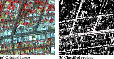
Figure 3: Intermediate results of road extraction
4. Estimating building height from Shadows
In conventional stereo processing techniques, heights of buildings can be estimated using two images of the same area acquired at different viewing directions. Building height can also be derived from a single image using a simple geometric method if shadows of the buildings can be located in the image. For example, in Figure 4, the height of the building (H) can be calculated from the length of its shadow (Ls) on the ground and the sun elevation angle (qs) using a simple trigonometric relation: H = Ls tan(qs). Very often, the base of a building in a satellite image is blocked by other surrounding structure such that the shadow length cannot be determined. In this case, it is still possible to determine the building height if both the top of the building (such as point P in Fig. 4) and its shadow (point Q in Fig. 4) can be located in the image. The building height can be obtained by using a geometric relation between the length of the line joining PQ on the image and the building height H.
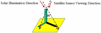
Figure 4: Geometry for estimating building from shadow
For example, Figure 5 shows the Chairman Mao Memorial Hall in Beijing. The top left corner of the roof top and its shadow can be seen clearly. The height of the building can be determined to be about 35 m with one or two meters error.
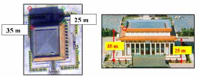
Figure 5: (left) Ikonos image of the Chairman Mao Memorial Hall in Beijing, China; (right) Photograph of the building..
5. Conclusion
In this paper, we have presented three potential new applications of the 1-meter IKONOS images. These applications demand the "common sense" type of knowledge that is relatively easy for human. However, due to the tediousness and extensiveness of the tasks, the automation of these tasks is invaluable. We have also shown that the automation of some of these tasks can be easily made possible using some existing tools.
References
- Brandtberg T., and Walter F., 1998. Automated delineation of individual tree crowns in high spatial resolution aerial images by multiple-scale analysis, Machine Vision and Applications (1998) 11:64-73.
- Coxeter, H.S.M., 1969. Introduction to geometry, 2nd Ed, New York, Wiley.