| GISdevelopment.net ---> AARS ---> ACRS 2000 ---> AirSar/Master |
Analysis of Multipolarization
and Multi-Band Radar Data Over Iloilo City and Vicinities
Michael B. LITUAÑAS, Jerry H.G. SALVADOR, Dulcisimo S. DOMINGO III, Aeschylus M.J. VALENZUELA and Eduardo O. CLARIDAD
Mines and Geosciences Bureau
North Avenue, Diliman, Quezon City, 1104, Philippines
Tel/Fax: (632) 928-8544
E-MAIL : totie@pacific.net.ph
Michael B. LITUAÑAS, Jerry H.G. SALVADOR, Dulcisimo S. DOMINGO III, Aeschylus M.J. VALENZUELA and Eduardo O. CLARIDAD
Mines and Geosciences Bureau
North Avenue, Diliman, Quezon City, 1104, Philippines
Tel/Fax: (632) 928-8544
E-MAIL : totie@pacific.net.ph
Keywords: AirSAR, Modified Rayleigh Criterion,
relief
Abstract
This research report is the synthesis of the image analysis and the result of the field verification using AirSAR data obtained over southeast Iloilo and northern Guimaras Island.
Iloilo generally has a flat relief. Broad alluvial plains stretch along the land. The coastal zone has several active tidal flats. Within the vicinities there are many gently sloping, low relief hills. In three test areas, we showed that multi-band radar data could help approximate the surface relief of materials in the field by describing the relief in terms of surface roughness calculated from the Modified Rayleigh Criterion. Such relief correlates with signatures in the radar image. We also showed closely the patterns of lineation in the Oton coast image correlating it with field observation deducing some of the process that took place in the past. In northern Guimaras, we identified and mapped several lithologies using the radar image.
We showed the AirSAR image's usefulness for geomorphologic terrain mapping. We identified three landforms namely, the fluvio-denudational landform, the fluvial landforms, and the fluvio-marine landforms.
1.0 Introduction
The use of multi-band and multi-polarized imaging radar data for geologic applications is new in the Philippines. Filipino researchers got the chance to use the multi-band and multi-polarized radar data upon participation to the Pacific Rim (PACRIM) airborne synthetic aperture radar (AirSAR) Mission in 1996. AirSAR is a 3-frequency, 4-polarization, SAR system - a multi-parameter system - carried on-board a DC-8 aircraft made by the National Aeronautics and Space Administration- Jet Propulsion Laboratories (NASA-JPL). One of the target areas is the southeastern coast of Iloilo and Guimaras Island. The report is the synthesis of the image analysis and field verification results of the AirSAR image taken over the southeastern coast of Iloilo and of Guimaras Island. Field inspection was conducted last April 15 to 19, 1999 by personnel from the MGB-Central and its Region 6 Office. This research is a sub-project under the major project entitled "Analysis of AirSAR and TopSAR Datasets for Resource Management and Development Planning Activities". The project's developmental objective is to "promote the use of remote sensing technology for various applications relating to resource management and developmental planning activities. The purpose of this study is coastal environment and geologic studies. We used the data to: 1) geologically map Iloilo City and the surrounding coastal areas in reference to the major lithologic and structural units, and 2) study the coastal environment and the impact assessment of flood-prone areas.
2.0 Description Of The Study Area
The study area is located in the southeastern coast of Panay Island and the northern part of Guimaras Island. From northeast to southwest, the major towns and cities in Iloilo are Dumangas, Zarraga, Leganes, Jaro, Iloilo City, and Oton. South of Iloilo City and separated from it by the Iloilo Strait is Guimaras Island. Panay and Guimaras Islands are portions of Visayas Islands that are found in the Central Philippines.
The AirSAR swath image has dimensions of 40.5km x 8.5 km, with the land area along coastal Iloilo is roughly 265 sq. km while that in Guimaras is roughly 32 sq. km (Figure 1).
Iloilo is a flat to almost flat relief of broad and poorly drained alluvial plain. Alluvial deposits of river and beach deposits of Recent age (GOP, 1996) comprise this wide plain. Cabatuan Formation underlains the plain with a series of sandstone, siltstone and mudstone. Much of the alluvial plain is cultivated for agricultural rice. The major cities and towns are also built on this plain. The major river systems in the Iloilo area are the Jalaud River in the northeast, the Jaro River and Iloilo River in the southwest. The last two rivers pass through Iloilo City. The coast has tidal flats and are used as fish pens and ponds.
In Guimaras, the study area ranges from sea level to 100m elevation. The area has many low relief hills and gentle slopes wherein forest covers the rolling hills. A diorite body intrudes the dominant limestone lithology (Abundo, et al, 1998). Quaternary alluvium is abundant along the coast. The dominant land uses are similar to that in Iloilo.
3.0 Methodology
3.1 Field Investigation and Data Integration
We produced preliminary maps after some preliminary interpretations were made. We conducted a fieldwork in Iloilo and Guimaras to verify the features observed in the AirSAR image and the accuracy of our preliminary maps and mapped the geologic and the geomorphologic terrain of Iloilo and Guimaras. We compiled all field data and updated all our preliminary maps. We compared and updated maps with the reference geologic and geomorphologic maps. The results of the image analysis, field investigation and data integration are presented in this report.
3.2 Image Processing
We used the Environment for Visualizing Images software (ENVI) version 3.1 to analyze the AirSAR data. We decompressed and synthesized all data of C-, L- and P-bands HH, VV, and HV polarizations, with an additional "total available power" band, from the Stokes Matrix compression. We corrected 12 bands all synthesized data, from slant to ground range and registered the corrected data to the map using ground control points (GCPs) from global positioning system (GPS) measurements in the field. The registered image is shown in figure 1. The C-, L- and P- bands were assigned to the Red-Green-Blue (RGB) color composite, respectively. We visually interpreted the image for geologic and geomorphologic features. From the main registered image, we selected three test areas for analysis namely, 1) in Dumangas, 2) in Oton and 3) in northern Guimaras (Figures 2,3 and 4). Using the subset command in ENVI, we created output files, enhanced each subset using interactive stretching and the lee filter and then interpreted each image.
4.0 Results And Discussion
4.1 Geologic and Geomorphologic Investigations
Quaternary Alluvium underlains Iloilo and composed of unconsolidated sand, silt, pebbles, and cobbles with broken shells and foraminefera. These are found on the floodplains, along the coast coasts and mouths of the rivers. Pebble- to cobble sized deposits predominate along the Oton coast and Guimaras Island inlet bay areas. The Dingle Limestone in Dumangas occurs as 25m low hill, and set against flat alluvial plain background. It is cream to gray in color, hard but fragmental in portions and has interbeds of coarse-grained sandstone. The Buenavista Limestone in Guimaras outcrops along the northwest coast, buff to gray-brown in color, appears massive and fossiliferous with some hexacorals partly replaced with calcite. It gently dips to the northwest with typical karst feature. The Guimaras Diorite composed of the minerals hornblende, feldspar (some show pinkish alterations), plagioclase (at times replaced by silica) vuggy quartz and pyrite disseminations. When weathered it shows oxidation and alteration to clay minerals. The outcrops in the northern and western part of Guimaras are low-lying hills, mounds and peaks ranging in elevation from 150m to 200m (Calomarde, 1987).
We identified homogenous landform association related to terrain characteristics using the parameters: genesis, relief and sediment type. First is the "fluvio-denudational landform", an alluvial and slope debris association (Javelosa, et al, 1994) from the base of western range of Panay Island to gently sloping alluvial plains, and cultivated for rice and floodplain areas used as fishponds. Second is the "fluvial landform" mainly by river actions. Northeast of Iloilo City, relief morphology is flat/almost flat where point bars, natural levees, backswamps and abandoned channels exist. The gentle slopes and high suspended load to bed ratio of sediments in the river system favor the meandering nature of the rivers. Alluvial, channel and overbank complexes, channel floodplain associations and natural levee are also observed within city limits. General relief is flat/almost flat. The third is "fluvio-marine landform" due by interaction of fluvial and marine processes along the coast, 10km northeast of Iloilo City. These are mostly active tidal flats, some are used as salt beds, and are gently sloping towards the Iloilo Strait marked by the wide tidal and fluvial channels in other areas.
In Figure 1,"broad fluvial-denudational landform" is in red color at the left side of the image. The high backscatter of agricultural crops in C-band is responsible for the red color. Fluvial landforms in bluish white delineate the river dominated areas. The dark sinuous patterns are meandering channels of main rivers and their tributaries. The fluvial-marine landforms have the active and relict tidal flats as salt beds and marine cultures. The tidal flats appear as dark colored areas with bright linear features of fish pens.
In terms of impact assessment for flooding hazard, the fluvio-marine environment is prone to frequent flooding mainly due to its low relief and geomorphologic setting. The next area prone to flooding is the fluvial environment. The rivers carry the flood waters and spills it over its banks. This area includes Iloilo City. We also noted the transgression of the sea inland to form inland tidal flats in Oton.
4.2 Image Processing Analysis on Test Areas Observations
Surface roughness is measured in centimeters and determined by textural features comparable in size to the radar wavelength, such as leaves and twigs of vegetation and sand, gravel and cobble particles (Sabins, 1987). The Dingle Limestone (blue outline) in Dumangas test area (Figure 2) shows a bright area in relatively dark areas. Its surrounding plain has agricultural crops and gravel (Lituanas, 1999) with actual size range of 2cm to 15cm of the AirSAR sensors, and show up as bright areas in C- and L-band but darker in the P-band. The limestone produces a backscatter related to its topographic relief. Thus, it shows up as a bright area in all 3 bands. Using Table 1, an object has to be >18.64cm to be rough and exhibit a bright response for the P-band. Anything that is <18.64cm will show up either as intermediate (gray color) or smooth (black). By contrast, if L- and C-bands are used, an object needs only be >1.56cm and 6.85cm to be rough and exhibit the same response. Since the vertical size range of the agricultural crops and the gravel is 2cm and 15cm, they also show up as bright areas in L-band and more so in the C-band. Thus, marking the limestone hill will be difficult in the C- and L-bands but not in the P-band. In the P-band, the hill is outlined by its bright response against the dark response of the alluvial plain with its vegetation and gravel.
In Oton test area (Figure 3), bright areas in the center image are newly developed urban areas. The rectangular-shaped, light toned objects on the right are agricultural areas. The dark areas in the upper part are land submerged in water due to the sea's transgression inland forming tidal flats. The beach area of sand and gravel deposit shows uniform intermediate response to the L-HH band, bright in C-HH band and dark in the P-HH band. Using Table 1, we can deduce the beach sand deposits in the range of 1.21cm and 6.8cm (intermediate). Pebble- sized sands and cobbles have composite size range of 0.4 cm to 25.6cm. These form a series of micro-ridges that lie sub-parallel to the curve of the coastline as outlined. It can be deduced that these are series of deposition of sediments parallel to the coastline caused by the interaction of the land and the sea. The relative uniformity of the size range is due to the winnowing effect of the waves. This explains the relatively uniform intermediate response in the L-HH image. Multi-band radar is useful in estimating surface relief of materials. We can state some of the process that took place in the past by observing closely the patterns of lineation on the coast, and correlating it with field observation.
The Guimaras test area (Figure 4) provides the radar data for lithologic terrain mapping. Geologic structure and erosional characteristics of underlying rocks control the topography. The Buenavista Limestone (50m to 80m el.) in white outline, exhibits a pitted texture of karst topography (Sabins, 1987) and has some bedding that forms asymmetric ridge. The beds dip gently to the northwest. On the lower right of the image is the Guimaras Diorite identified in the field as quartz diorite porphyry. It has a higher relief than the limestone, producing a bright backscatter and shows no definitive pattern. On the upper part is the Quaternary alluvium that exhibits a fine texture, dark gray color and forms as fringe on the northwest side of the limestone.
5.0 Summary and conclusions
In the test areas, we demonstrated that multi-band radar data could help approximate the surface relief of materials in the field by describing the relief in terms of surface roughness derived from the Modified Rayleigh Criterion. Such relief correlates with signatures in the radar image. By observing closely the patterns of lineation in the Oton coast image and by correlating it with field observation, we could deduce some of the process that took place in the past.
We demonstrated that L-band radar is useful for recognizing major lithologic terrain in a tropical environment such as in Guimaras. These are (1) the Buenavista Limestone - karstic, gently dipping and fossiliferrous limestone in north and northwest Guimaras (2) the Guimaras Diorite - as low-lying hills and mounds in northern and central parts; (3) and the Quaternary Alluvium - the sediments along the coast, along river deltas and active tidal flats.
We also showed that AirSAR image is useful for geomorphologic terrain mapping. We identified three landforms namely, the fluvio-denudational, the fluvial and the fluvio-marine landforms. Lastly, by comparing the present image with an existing reference map, we can detect changes in the land cover and in the geomorphologic setting of the area. In terms of impact assessment for flooding hazard of the three terrain, the fluvio-marine environment is prone to frequent flooding mainly due to its low relief and geomorphologic setting. The next area prone to flooding is the fluvial environment.
6.0 Acknowledgment
We thank the DOST-PCASTRD for the generous financial support to this project. We also thank our colleagues at the MGB Central Office and Regional Office No.6, personnel from NAMRIA and UP-TCAGP for joining us in the field. We also appreciate Mr. Bobby Crisostomo of NAMRIA for his leadership in this project.
7.0 References
Table 1. Summary of the calculation
results for the AirSAR bands using the Modified Rayleigh Criterion (Peake
and Oliver,1971) at a look angle of 560. Values
are in cm. H refers to the vertical height of the object
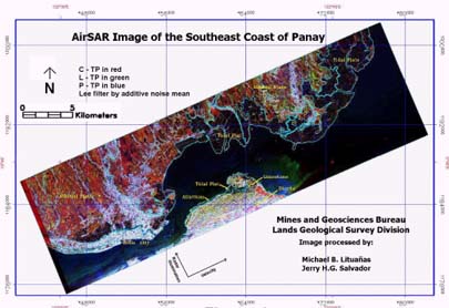
Figure 1:
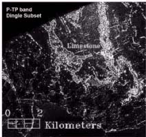
Figure 2:Dingle Limestone
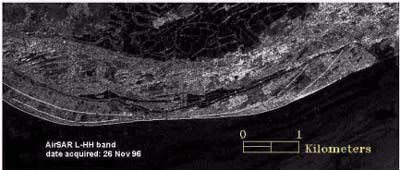
Figure 3:Oton Coastline
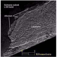
Figure 4: Guimaras Diorite
Abstract
This research report is the synthesis of the image analysis and the result of the field verification using AirSAR data obtained over southeast Iloilo and northern Guimaras Island.
Iloilo generally has a flat relief. Broad alluvial plains stretch along the land. The coastal zone has several active tidal flats. Within the vicinities there are many gently sloping, low relief hills. In three test areas, we showed that multi-band radar data could help approximate the surface relief of materials in the field by describing the relief in terms of surface roughness calculated from the Modified Rayleigh Criterion. Such relief correlates with signatures in the radar image. We also showed closely the patterns of lineation in the Oton coast image correlating it with field observation deducing some of the process that took place in the past. In northern Guimaras, we identified and mapped several lithologies using the radar image.
We showed the AirSAR image's usefulness for geomorphologic terrain mapping. We identified three landforms namely, the fluvio-denudational landform, the fluvial landforms, and the fluvio-marine landforms.
1.0 Introduction
The use of multi-band and multi-polarized imaging radar data for geologic applications is new in the Philippines. Filipino researchers got the chance to use the multi-band and multi-polarized radar data upon participation to the Pacific Rim (PACRIM) airborne synthetic aperture radar (AirSAR) Mission in 1996. AirSAR is a 3-frequency, 4-polarization, SAR system - a multi-parameter system - carried on-board a DC-8 aircraft made by the National Aeronautics and Space Administration- Jet Propulsion Laboratories (NASA-JPL). One of the target areas is the southeastern coast of Iloilo and Guimaras Island. The report is the synthesis of the image analysis and field verification results of the AirSAR image taken over the southeastern coast of Iloilo and of Guimaras Island. Field inspection was conducted last April 15 to 19, 1999 by personnel from the MGB-Central and its Region 6 Office. This research is a sub-project under the major project entitled "Analysis of AirSAR and TopSAR Datasets for Resource Management and Development Planning Activities". The project's developmental objective is to "promote the use of remote sensing technology for various applications relating to resource management and developmental planning activities. The purpose of this study is coastal environment and geologic studies. We used the data to: 1) geologically map Iloilo City and the surrounding coastal areas in reference to the major lithologic and structural units, and 2) study the coastal environment and the impact assessment of flood-prone areas.
2.0 Description Of The Study Area
The study area is located in the southeastern coast of Panay Island and the northern part of Guimaras Island. From northeast to southwest, the major towns and cities in Iloilo are Dumangas, Zarraga, Leganes, Jaro, Iloilo City, and Oton. South of Iloilo City and separated from it by the Iloilo Strait is Guimaras Island. Panay and Guimaras Islands are portions of Visayas Islands that are found in the Central Philippines.
The AirSAR swath image has dimensions of 40.5km x 8.5 km, with the land area along coastal Iloilo is roughly 265 sq. km while that in Guimaras is roughly 32 sq. km (Figure 1).
Iloilo is a flat to almost flat relief of broad and poorly drained alluvial plain. Alluvial deposits of river and beach deposits of Recent age (GOP, 1996) comprise this wide plain. Cabatuan Formation underlains the plain with a series of sandstone, siltstone and mudstone. Much of the alluvial plain is cultivated for agricultural rice. The major cities and towns are also built on this plain. The major river systems in the Iloilo area are the Jalaud River in the northeast, the Jaro River and Iloilo River in the southwest. The last two rivers pass through Iloilo City. The coast has tidal flats and are used as fish pens and ponds.
In Guimaras, the study area ranges from sea level to 100m elevation. The area has many low relief hills and gentle slopes wherein forest covers the rolling hills. A diorite body intrudes the dominant limestone lithology (Abundo, et al, 1998). Quaternary alluvium is abundant along the coast. The dominant land uses are similar to that in Iloilo.
3.0 Methodology
3.1 Field Investigation and Data Integration
We produced preliminary maps after some preliminary interpretations were made. We conducted a fieldwork in Iloilo and Guimaras to verify the features observed in the AirSAR image and the accuracy of our preliminary maps and mapped the geologic and the geomorphologic terrain of Iloilo and Guimaras. We compiled all field data and updated all our preliminary maps. We compared and updated maps with the reference geologic and geomorphologic maps. The results of the image analysis, field investigation and data integration are presented in this report.
3.2 Image Processing
We used the Environment for Visualizing Images software (ENVI) version 3.1 to analyze the AirSAR data. We decompressed and synthesized all data of C-, L- and P-bands HH, VV, and HV polarizations, with an additional "total available power" band, from the Stokes Matrix compression. We corrected 12 bands all synthesized data, from slant to ground range and registered the corrected data to the map using ground control points (GCPs) from global positioning system (GPS) measurements in the field. The registered image is shown in figure 1. The C-, L- and P- bands were assigned to the Red-Green-Blue (RGB) color composite, respectively. We visually interpreted the image for geologic and geomorphologic features. From the main registered image, we selected three test areas for analysis namely, 1) in Dumangas, 2) in Oton and 3) in northern Guimaras (Figures 2,3 and 4). Using the subset command in ENVI, we created output files, enhanced each subset using interactive stretching and the lee filter and then interpreted each image.
4.0 Results And Discussion
4.1 Geologic and Geomorphologic Investigations
Quaternary Alluvium underlains Iloilo and composed of unconsolidated sand, silt, pebbles, and cobbles with broken shells and foraminefera. These are found on the floodplains, along the coast coasts and mouths of the rivers. Pebble- to cobble sized deposits predominate along the Oton coast and Guimaras Island inlet bay areas. The Dingle Limestone in Dumangas occurs as 25m low hill, and set against flat alluvial plain background. It is cream to gray in color, hard but fragmental in portions and has interbeds of coarse-grained sandstone. The Buenavista Limestone in Guimaras outcrops along the northwest coast, buff to gray-brown in color, appears massive and fossiliferous with some hexacorals partly replaced with calcite. It gently dips to the northwest with typical karst feature. The Guimaras Diorite composed of the minerals hornblende, feldspar (some show pinkish alterations), plagioclase (at times replaced by silica) vuggy quartz and pyrite disseminations. When weathered it shows oxidation and alteration to clay minerals. The outcrops in the northern and western part of Guimaras are low-lying hills, mounds and peaks ranging in elevation from 150m to 200m (Calomarde, 1987).
We identified homogenous landform association related to terrain characteristics using the parameters: genesis, relief and sediment type. First is the "fluvio-denudational landform", an alluvial and slope debris association (Javelosa, et al, 1994) from the base of western range of Panay Island to gently sloping alluvial plains, and cultivated for rice and floodplain areas used as fishponds. Second is the "fluvial landform" mainly by river actions. Northeast of Iloilo City, relief morphology is flat/almost flat where point bars, natural levees, backswamps and abandoned channels exist. The gentle slopes and high suspended load to bed ratio of sediments in the river system favor the meandering nature of the rivers. Alluvial, channel and overbank complexes, channel floodplain associations and natural levee are also observed within city limits. General relief is flat/almost flat. The third is "fluvio-marine landform" due by interaction of fluvial and marine processes along the coast, 10km northeast of Iloilo City. These are mostly active tidal flats, some are used as salt beds, and are gently sloping towards the Iloilo Strait marked by the wide tidal and fluvial channels in other areas.
In Figure 1,"broad fluvial-denudational landform" is in red color at the left side of the image. The high backscatter of agricultural crops in C-band is responsible for the red color. Fluvial landforms in bluish white delineate the river dominated areas. The dark sinuous patterns are meandering channels of main rivers and their tributaries. The fluvial-marine landforms have the active and relict tidal flats as salt beds and marine cultures. The tidal flats appear as dark colored areas with bright linear features of fish pens.
In terms of impact assessment for flooding hazard, the fluvio-marine environment is prone to frequent flooding mainly due to its low relief and geomorphologic setting. The next area prone to flooding is the fluvial environment. The rivers carry the flood waters and spills it over its banks. This area includes Iloilo City. We also noted the transgression of the sea inland to form inland tidal flats in Oton.
4.2 Image Processing Analysis on Test Areas Observations
Surface roughness is measured in centimeters and determined by textural features comparable in size to the radar wavelength, such as leaves and twigs of vegetation and sand, gravel and cobble particles (Sabins, 1987). The Dingle Limestone (blue outline) in Dumangas test area (Figure 2) shows a bright area in relatively dark areas. Its surrounding plain has agricultural crops and gravel (Lituanas, 1999) with actual size range of 2cm to 15cm of the AirSAR sensors, and show up as bright areas in C- and L-band but darker in the P-band. The limestone produces a backscatter related to its topographic relief. Thus, it shows up as a bright area in all 3 bands. Using Table 1, an object has to be >18.64cm to be rough and exhibit a bright response for the P-band. Anything that is <18.64cm will show up either as intermediate (gray color) or smooth (black). By contrast, if L- and C-bands are used, an object needs only be >1.56cm and 6.85cm to be rough and exhibit the same response. Since the vertical size range of the agricultural crops and the gravel is 2cm and 15cm, they also show up as bright areas in L-band and more so in the C-band. Thus, marking the limestone hill will be difficult in the C- and L-bands but not in the P-band. In the P-band, the hill is outlined by its bright response against the dark response of the alluvial plain with its vegetation and gravel.
In Oton test area (Figure 3), bright areas in the center image are newly developed urban areas. The rectangular-shaped, light toned objects on the right are agricultural areas. The dark areas in the upper part are land submerged in water due to the sea's transgression inland forming tidal flats. The beach area of sand and gravel deposit shows uniform intermediate response to the L-HH band, bright in C-HH band and dark in the P-HH band. Using Table 1, we can deduce the beach sand deposits in the range of 1.21cm and 6.8cm (intermediate). Pebble- sized sands and cobbles have composite size range of 0.4 cm to 25.6cm. These form a series of micro-ridges that lie sub-parallel to the curve of the coastline as outlined. It can be deduced that these are series of deposition of sediments parallel to the coastline caused by the interaction of the land and the sea. The relative uniformity of the size range is due to the winnowing effect of the waves. This explains the relatively uniform intermediate response in the L-HH image. Multi-band radar is useful in estimating surface relief of materials. We can state some of the process that took place in the past by observing closely the patterns of lineation on the coast, and correlating it with field observation.
The Guimaras test area (Figure 4) provides the radar data for lithologic terrain mapping. Geologic structure and erosional characteristics of underlying rocks control the topography. The Buenavista Limestone (50m to 80m el.) in white outline, exhibits a pitted texture of karst topography (Sabins, 1987) and has some bedding that forms asymmetric ridge. The beds dip gently to the northwest. On the lower right of the image is the Guimaras Diorite identified in the field as quartz diorite porphyry. It has a higher relief than the limestone, producing a bright backscatter and shows no definitive pattern. On the upper part is the Quaternary alluvium that exhibits a fine texture, dark gray color and forms as fringe on the northwest side of the limestone.
5.0 Summary and conclusions
In the test areas, we demonstrated that multi-band radar data could help approximate the surface relief of materials in the field by describing the relief in terms of surface roughness derived from the Modified Rayleigh Criterion. Such relief correlates with signatures in the radar image. By observing closely the patterns of lineation in the Oton coast image and by correlating it with field observation, we could deduce some of the process that took place in the past.
We demonstrated that L-band radar is useful for recognizing major lithologic terrain in a tropical environment such as in Guimaras. These are (1) the Buenavista Limestone - karstic, gently dipping and fossiliferrous limestone in north and northwest Guimaras (2) the Guimaras Diorite - as low-lying hills and mounds in northern and central parts; (3) and the Quaternary Alluvium - the sediments along the coast, along river deltas and active tidal flats.
We also showed that AirSAR image is useful for geomorphologic terrain mapping. We identified three landforms namely, the fluvio-denudational, the fluvial and the fluvio-marine landforms. Lastly, by comparing the present image with an existing reference map, we can detect changes in the land cover and in the geomorphologic setting of the area. In terms of impact assessment for flooding hazard of the three terrain, the fluvio-marine environment is prone to frequent flooding mainly due to its low relief and geomorphologic setting. The next area prone to flooding is the fluvial environment.
6.0 Acknowledgment
We thank the DOST-PCASTRD for the generous financial support to this project. We also thank our colleagues at the MGB Central Office and Regional Office No.6, personnel from NAMRIA and UP-TCAGP for joining us in the field. We also appreciate Mr. Bobby Crisostomo of NAMRIA for his leadership in this project.
7.0 References
- Abundo, R.V., Parringit, E., Domingo III, D.S. and Lituanas, M.B., 1998. AirSAR Capability to Geomorphology and Geologic Mapping Application. Proceedings of the 19th Asian Conference on Remote Sensing, pp. J-2-1 - J-2-5, Manila, Philippines.
- Calomarde, R.I., 1987a. Geology and Geomorphological Terrain Classification of the Guimaras Island, Iloilo City. Mines and Geosciences Development Services Regional Office No. 06, Iloilo City, Philippines.
- Evans, D.L., Farr, T.G., Van Zyl, J.J., Zebker, H.A., 1988. Radar Polarimetry: Analysis and Applications. EEE Transactions on Geoscience and Remote Sensing, 26, pp.774-789.
- Geology of the Philippines,1996. Unedited version. Mines and Geosciences Bureau.
- Hewson, R.D and Taylor, G.R., 1995. AirSAR Imagery as an Ancillary Data Set for Geological Mapping and Fowlers Gap, Western New South Wales. Proceedings of the International Workshop on Radar Image Processing and Applications held in the UNSW, Sydney in November 6-8, 1995.
- Javelosa, R.,1994. Report on the Quaternary Geological and Geomorphological Survey of Iloilo City. Mines and Geosciences Bureau, Quezon City, Philippines.
- Sabins, Jr., F.F.,1987. Remote Sensing: Principles and Interpretation, 2nd ed. (New York: W.H. Freeman and Company).
| Category | C-band | L-band | P-band | Signature as observed In the image |
| Smooth | H< 0.275 | H<1.21 | H<3.28 | Dark |
| Intermediate | 1.56<H<.275 | 6.85<H<1.21 | 18.64<H3.28 | Shades of gray |
| Rough | H>1.56 | H>6.85 | H>18.64 | Bright white |
Figure 1:
Figure 2:Dingle Limestone
Figure 3:Oton Coastline
Figure 4: Guimaras Diorite