| GISdevelopment.net ---> AARS ---> ACRS 2000 ---> AirSar/Master |
Benefits of Topsar Radar
Interferometry in Tropical Terrains
Dr. Ian J. Tapley
Cooperative Research Centre for Landscape Evolution and Mineral Exploration
CSIRO Exploration and Mining, Private Mail Bag No 5, Wembley, Western Australia 6913
Telephone: 61 8 9333 6263 Facsimile: 61 8 9383 9179 E-mail:i.tapley@per.dem.csiro.au
Dr. Ian J. Tapley
Cooperative Research Centre for Landscape Evolution and Mineral Exploration
CSIRO Exploration and Mining, Private Mail Bag No 5, Wembley, Western Australia 6913
Telephone: 61 8 9333 6263 Facsimile: 61 8 9383 9179 E-mail:i.tapley@per.dem.csiro.au
Summary
TOPSAR (TOPographic Synthetic Aperture Radar) is an aircraft-mounted radar interferometer that uses radar and interferometry to rapidly produce high-resolution topographic maps of the earth's surface. Such is the precision that in many applications, this radar technique has the potential of being a viable alternative to conventional photogrammetric techniques that use aerial photography. For example, when operating in the 40 MHz bandwidth, TOPSAR height measurements are made for every 4.63 x 3.3 m posting along a flight swath 10 km wide and typically 60 km long. In low relief terrains, sub-metre height accuracy's are typical whilst in high relief areas, height differences of 3-5 m are resolved. The process needs no gridding or interpolation as required for digital elevation models (DEMs) generated from stereo pairs of optical imagery. In addition, the technique has the advantages of automatic processing of the data, and operation in cloud, smoke and rainfall conditions, night and day. Thus radar interferometry is very appropriate for operations in humid tropical climates that normally prohibit the successful acquisition of optical products such as aerial photographs and SPOT-PAN imagery. TOPSAR has been developed by NASA-JPL as a proof of concept and a pre-cursor for future spaceborne missions including the highly successful February 2000 Shuttle Radar Topographic Mapping Mission (SRTM) (http://www-radar.jpl.nasa.gov/srtm/).
TOPSAR operates in C-band (5.56 cm wavelength) using the phase difference information captured from the VV-polarization signals received at two antennas mounted on the fuselage of NASA's DC-8 research aircraft. It effectively replaces the C-band polarimeter instrument in the existing AIRSAR hardware (Zebker et al, 1992), but the remaining L- and P-band systems are undisturbed and operate together with the TOPSAR hardware. Therefore, the combined instrument produces simultaneous L- and P-band fully polarimetric plus C-band VV polarization backscatter images in addition to the topographic product.
The output of high precision TOPSAR datasets is accomplished by comprehensive navigational systems to determine the precise position of the DC-8 aircraft, and full motion compensation algorithms in the TOPSAR processor to accommodate large translational and altitude perturbations during the data recording process (Madsen et al, 1995). Because the TOPSAR processor outputs the data with uniform x and y 5 m spacings, it recognizes and compensates for intrinsic distortions in the signal such as foreshortening. Areas of layover in high relief areas are also recognized, discarded and filled in by linear interpolation.
Apart from the digital elevation data, L- and P-band polarimetric and Cvv data, the TOPSAR data package also includes a local incidence angle image and an image of the correlation between the interferometric channels to assess the relative height accuracy of the data (van Zyl et al, 1995). All datasets are registered and projected to groundrange. The C-band digital elevation information is used to geometrically resample the radar images to correct for the effects of topography on the radar imaging geometry. All radar images are radiometrically corrected by taking into account the effects of topography as described by van Zyl et al (1993).
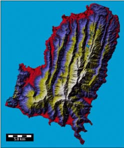
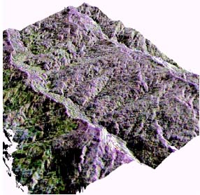
During the PacRim AIRSAR missions in 1996 and 2000 quality TOPSAR datasets were collected in the humid-tropical environments of Papua New Guinea, Indonesia, Malaysia, Brunei, Cambodia, Vietnam, Philippines, Taiwan and South Korea. The accuracy of the data lends itself to generating precision geomorphometric and structural detail in these regions. A shaded relief image (below left) and 3D perspective image (below right) highlight foliation and trends within a metamorphic core complex masked by a canopy of tropical vegetation in Papua New Guinea. It is evident that the top of the vegetation canopy conforms to the underlying topography that, in turn, is controlled by geological features and geomorphic processes. The majority of the short wavelength C-band radar backscatter is from the canopy surface thereby providing a reasonably accurate digital elevation product of the terrain.
References
TOPSAR (TOPographic Synthetic Aperture Radar) is an aircraft-mounted radar interferometer that uses radar and interferometry to rapidly produce high-resolution topographic maps of the earth's surface. Such is the precision that in many applications, this radar technique has the potential of being a viable alternative to conventional photogrammetric techniques that use aerial photography. For example, when operating in the 40 MHz bandwidth, TOPSAR height measurements are made for every 4.63 x 3.3 m posting along a flight swath 10 km wide and typically 60 km long. In low relief terrains, sub-metre height accuracy's are typical whilst in high relief areas, height differences of 3-5 m are resolved. The process needs no gridding or interpolation as required for digital elevation models (DEMs) generated from stereo pairs of optical imagery. In addition, the technique has the advantages of automatic processing of the data, and operation in cloud, smoke and rainfall conditions, night and day. Thus radar interferometry is very appropriate for operations in humid tropical climates that normally prohibit the successful acquisition of optical products such as aerial photographs and SPOT-PAN imagery. TOPSAR has been developed by NASA-JPL as a proof of concept and a pre-cursor for future spaceborne missions including the highly successful February 2000 Shuttle Radar Topographic Mapping Mission (SRTM) (http://www-radar.jpl.nasa.gov/srtm/).
TOPSAR operates in C-band (5.56 cm wavelength) using the phase difference information captured from the VV-polarization signals received at two antennas mounted on the fuselage of NASA's DC-8 research aircraft. It effectively replaces the C-band polarimeter instrument in the existing AIRSAR hardware (Zebker et al, 1992), but the remaining L- and P-band systems are undisturbed and operate together with the TOPSAR hardware. Therefore, the combined instrument produces simultaneous L- and P-band fully polarimetric plus C-band VV polarization backscatter images in addition to the topographic product.
The output of high precision TOPSAR datasets is accomplished by comprehensive navigational systems to determine the precise position of the DC-8 aircraft, and full motion compensation algorithms in the TOPSAR processor to accommodate large translational and altitude perturbations during the data recording process (Madsen et al, 1995). Because the TOPSAR processor outputs the data with uniform x and y 5 m spacings, it recognizes and compensates for intrinsic distortions in the signal such as foreshortening. Areas of layover in high relief areas are also recognized, discarded and filled in by linear interpolation.
Apart from the digital elevation data, L- and P-band polarimetric and Cvv data, the TOPSAR data package also includes a local incidence angle image and an image of the correlation between the interferometric channels to assess the relative height accuracy of the data (van Zyl et al, 1995). All datasets are registered and projected to groundrange. The C-band digital elevation information is used to geometrically resample the radar images to correct for the effects of topography on the radar imaging geometry. All radar images are radiometrically corrected by taking into account the effects of topography as described by van Zyl et al (1993).
During the PacRim AIRSAR missions in 1996 and 2000 quality TOPSAR datasets were collected in the humid-tropical environments of Papua New Guinea, Indonesia, Malaysia, Brunei, Cambodia, Vietnam, Philippines, Taiwan and South Korea. The accuracy of the data lends itself to generating precision geomorphometric and structural detail in these regions. A shaded relief image (below left) and 3D perspective image (below right) highlight foliation and trends within a metamorphic core complex masked by a canopy of tropical vegetation in Papua New Guinea. It is evident that the top of the vegetation canopy conforms to the underlying topography that, in turn, is controlled by geological features and geomorphic processes. The majority of the short wavelength C-band radar backscatter is from the canopy surface thereby providing a reasonably accurate digital elevation product of the terrain.
References
- Madsen, S. N., Martin, J.M. and Zebker, H.A. 1993. Analysis and Evaluation of the NASA/JPL Across-Track Interferometric SAR System. IEEE Trans. Geosci. Remote Sensing, vol. 33, no 2, pp. 383-391.
- Thompson, T.W., Zebker, H.A., Carande, R.E., Rosen, P.A., Madsen, S.N., Hensley, S., Rodriguez, E., van Zyl, J.J., Martin, J.M. and Miller, T.W. 1994. NASA/JPL TOPSAR Interferometric SAR. World Wide Web, NASA/JPL Imaging Radar Homepage, http://southport.jpl.nasa.gov/topsardesc.html
- van Zyl, J.J., 1993, The effect of topography on radar scattering from vegetated areas, IEEE Trans. Geosci. Remote Sensing, vol. 31, no. 1, pp. 153-160.
- Van Zyl, J.J., Zebker, H.A., Hensley, S., Haub, D. and Wiesbeck, W., 1995. The New Dual Frequency (C- and L-Band) TOPSAR Airborne Interferometric SAR. http://www.jpl.nasa.gov/techreport/1995/95-0530.rfr.html
- Zebker, H.A., Madsen, S.N., Martin, J., Wheeler, K.B., Miller, T., Lou, Y., Alberti, G., Vetrella, S. and Cucci, A., 1992. The TOPSAR Interferometric Radar Topographic Mapping Instrument. IEEE Transactions on Geoscience and Remote Sensing, Vol. 30, No. 5, pp. 933-939.