| GISdevelopment.net ---> AARS ---> ACRS 2000 ---> AirSar/Master |
Estimation of Soil Moisture
with Vegetated Surface by Multi-Temporal Measurements
Jiancheng Shi
Institute for Computational Earth System Science
University of California, Santa Barbara
Tel: 805-893-2309, Fax: 805-893-2578
E-MAIL : shi@icess.ucsb.edu
Jiancheng Shi
Institute for Computational Earth System Science
University of California, Santa Barbara
Tel: 805-893-2309, Fax: 805-893-2578
E-MAIL : shi@icess.ucsb.edu
Introduction
During recent years, theoretical modeling and field experiments have established the fundamentals of active microwave remote sensing as an important tool in determining physical properties of soil. The ability to estimate soil moisture in the surface layer to an approximately 5 cm depth by microwave remote sensing has been demonstrated under a variety of the topographic and land cover conditions (Engman et al., 1995). Despite the promise, its application to hydrological and agricultural sciences has been hampered by natural variability and the complexity of the vegetation canopy and surface roughness that significantly affect the sensitivity of radar backscattering to soil moisture.
Although experiments demonstrated radar sensitivity to soil moisture variation more than two decades ago (Ulaby, 1974), an operational algorithm for mapping soil moisture distribution has not been developed because of the effects of the surface roughness and vegetation cover. The inversion of soil moisture information from radar backscatter became more rigorous after the availability of multi-polarization radar data. Several algorithms have been developed for measuring bare surface soil moisture quantitatively using either dual-polarization L-band SAR image data (Dubois et al., 1995, Ulaby et al., 1996 and Shi et al., 1997) or three-polarization SAR measurements (Oh et al., 1992). The algorithms had been applied to a series of L-band SIR-C and JPL/AIRSAR image data successfully by using VV and HH polarization (Dubois 1995 and Shi 1997). However, all those algorithms were under the surface scattering consideration. They used the weighted combinations of the different polarization signatures to minimize the effect of surface roughness so that soil moisture can be directly inferred from SAR image data. The effect of vegetation cover has not been included in current available algorithms. It is clear that vegetation cover will cause an under-estimation of soil moisture and an over-estimation of surface roughness when we apply the algorithm for bare surface soil moisture estimation to vegetation covered regions.
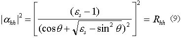
A polarimetric SAR backscatter measurements, by using eigenvalues and eigenvectors of the covariance matrix, can be decomposed to into three components based on the scattering types - (1) an odd number of reflections, (2) an even number reflections, and (3) a cross-polarized scattering power [Van]. It can be written as

In this study, we evaluate the usage of the decomposition theory in application of estimating soil moisture for vegetated surface with the temporal fully polarimetric L-band SAR meaurements. Using the decomposed scattering measurements from JPL/AIRSAR image data, we evaluated their usage to reduce the vegetation effect on estimation soil moisture under configurations of a single-frequency (L-band) and multi-pass with a same incidence.
Relations the Components in Backscattering Model and the Decomposed Scattering Components
In consideration of a more general natural vegetated surface, we construct our first-order physical based scattering model as a discontinuous vegetated backscattering model. This model can be written as
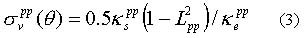
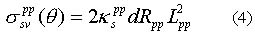
Since both volume extinction and scattering coefficients are strongly depended on the number density, shape and size parameters, as well as orientation or structure of the vegetation canopy, in addition to canopy thickness, it would be extremely difficult to estimate the surface scattering component or soil moisture from a limited SAR measurements.
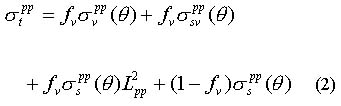
By comparison of backscattering components in (2) and the decomposed scattering components in (1), we can approximately write
Advantage of (2) is that it represents a general case of natural surface. It can be applied to both the fully vegetated surface (continuous layered vegetation when fv = 1) and the bare surface (when fv = 0).
Data Analysis Under Multi-Temporal Measurements Configuration
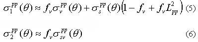
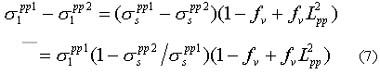
The temporal variability of surface roughness and vegetation cover are generally at much longer time scale than that of soil moisture. Unless there is a human activity we may reasonably assume that both surface roughness and vegetation cover are same at time interval from a few days to a week. The change in SAR measurements between the repeat passes, therefore, is resulted from the change of ground dielectric properties or soil moisture. Under this configuration, using two repeat pass polarimetric SAR measurements, we can write the difference of the first components
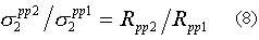
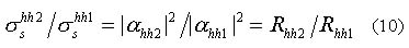
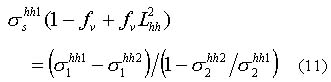
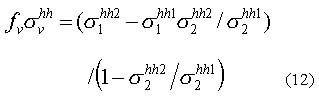
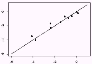
The SAR data used in this study was from the Washita '92 experiment. During the experiment from June 10-18, 1992, a time series of spatially distributed hydrologic data focusing on soil moisture and evaporative fluxes were collected. At the same time, the AIRSAR sensor aboard the NASA DC-8 aircraft collected a sequence of 6 L band radar images over an agricultural test site located just outside the watershed. The Washita '92 experiment was conducted immediately following a series of heavy rainfalls that ended on June 9. Thereafter, no more rain occurred throughout the entire series of the AIRSAR flights, thus allowing observation of a drying-down sequence. From any two of 6 sequence SAR measurements, we can estimated the surface and volume backscattering components using (11) and (12). Furthermore, the relative change in dielectric property of any pair from 6 sequence SAR measurements can be estimated by (10).
Reference
During recent years, theoretical modeling and field experiments have established the fundamentals of active microwave remote sensing as an important tool in determining physical properties of soil. The ability to estimate soil moisture in the surface layer to an approximately 5 cm depth by microwave remote sensing has been demonstrated under a variety of the topographic and land cover conditions (Engman et al., 1995). Despite the promise, its application to hydrological and agricultural sciences has been hampered by natural variability and the complexity of the vegetation canopy and surface roughness that significantly affect the sensitivity of radar backscattering to soil moisture.
Although experiments demonstrated radar sensitivity to soil moisture variation more than two decades ago (Ulaby, 1974), an operational algorithm for mapping soil moisture distribution has not been developed because of the effects of the surface roughness and vegetation cover. The inversion of soil moisture information from radar backscatter became more rigorous after the availability of multi-polarization radar data. Several algorithms have been developed for measuring bare surface soil moisture quantitatively using either dual-polarization L-band SAR image data (Dubois et al., 1995, Ulaby et al., 1996 and Shi et al., 1997) or three-polarization SAR measurements (Oh et al., 1992). The algorithms had been applied to a series of L-band SIR-C and JPL/AIRSAR image data successfully by using VV and HH polarization (Dubois 1995 and Shi 1997). However, all those algorithms were under the surface scattering consideration. They used the weighted combinations of the different polarization signatures to minimize the effect of surface roughness so that soil moisture can be directly inferred from SAR image data. The effect of vegetation cover has not been included in current available algorithms. It is clear that vegetation cover will cause an under-estimation of soil moisture and an over-estimation of surface roughness when we apply the algorithm for bare surface soil moisture estimation to vegetation covered regions.
A polarimetric SAR backscatter measurements, by using eigenvalues and eigenvectors of the covariance matrix, can be decomposed to into three components based on the scattering types - (1) an odd number of reflections, (2) an even number reflections, and (3) a cross-polarized scattering power [Van]. It can be written as
In this study, we evaluate the usage of the decomposition theory in application of estimating soil moisture for vegetated surface with the temporal fully polarimetric L-band SAR meaurements. Using the decomposed scattering measurements from JPL/AIRSAR image data, we evaluated their usage to reduce the vegetation effect on estimation soil moisture under configurations of a single-frequency (L-band) and multi-pass with a same incidence.
Relations the Components in Backscattering Model and the Decomposed Scattering Components
In consideration of a more general natural vegetated surface, we construct our first-order physical based scattering model as a discontinuous vegetated backscattering model. This model can be written as
Since both volume extinction and scattering coefficients are strongly depended on the number density, shape and size parameters, as well as orientation or structure of the vegetation canopy, in addition to canopy thickness, it would be extremely difficult to estimate the surface scattering component or soil moisture from a limited SAR measurements.
By comparison of backscattering components in (2) and the decomposed scattering components in (1), we can approximately write
Advantage of (2) is that it represents a general case of natural surface. It can be applied to both the fully vegetated surface (continuous layered vegetation when fv = 1) and the bare surface (when fv = 0).
Data Analysis Under Multi-Temporal Measurements Configuration
The temporal variability of surface roughness and vegetation cover are generally at much longer time scale than that of soil moisture. Unless there is a human activity we may reasonably assume that both surface roughness and vegetation cover are same at time interval from a few days to a week. The change in SAR measurements between the repeat passes, therefore, is resulted from the change of ground dielectric properties or soil moisture. Under this configuration, using two repeat pass polarimetric SAR measurements, we can write the difference of the first components
The SAR data used in this study was from the Washita '92 experiment. During the experiment from June 10-18, 1992, a time series of spatially distributed hydrologic data focusing on soil moisture and evaporative fluxes were collected. At the same time, the AIRSAR sensor aboard the NASA DC-8 aircraft collected a sequence of 6 L band radar images over an agricultural test site located just outside the watershed. The Washita '92 experiment was conducted immediately following a series of heavy rainfalls that ended on June 9. Thereafter, no more rain occurred throughout the entire series of the AIRSAR flights, thus allowing observation of a drying-down sequence. From any two of 6 sequence SAR measurements, we can estimated the surface and volume backscattering components using (11) and (12). Furthermore, the relative change in dielectric property of any pair from 6 sequence SAR measurements can be estimated by (10).
Reference
- E. T. Engman and N. Chauhan, " Status of Microwave Soil Measurements with Remote Sensing", Remote Sensing Environ., vol 51, no. 1, pp. 189-198, 1995.
- F. T. Ulaby, J. Cihlar, and R. K. Moore, "Active Microwave Measurement of Soil Water Content", Remote Sensing Environ., (3):185-203, 1974.
- P. C. Dubois, J. J. Van Zyl, and E. T. Engman, "Measuring soil moisture with imaging radar", IEEE Trans. Geosci. and Remote Sens., vol. 33, no. 4, pp. 195-926, 1995.
- F. T. Ulaby, P. C. Dubois, and J. J. Van Zyl, "Radar Mapping of Surface Soil Moisture", J. of Hydrology, 184, 57-84, 1996.
- J. Shi, J. Wang, A. Hsu, P. O'Neill, and E. T. Engman, "Estimation of bare surface soil moisture and surface roughness parameters using L-band SAR image data", In press, IEEE Transactions on Geoscience and Remote Sensing, 1997.
- Y. Oh, K. Sarabandi, and F. T. Ulaby. "An empirical model and inversion technique for radar scattering from bare soil surface", IEEE Trans. Geosci. Remote Sens., vol. 30, no. 2, pp 370-381, 1992.
- S. R. Cloude, "Uniqueness of target decomposition theorems in radar polarimetry", in Direct and inverse methods in radar polarimetry: Part 1, Kluwer Academic Publishers, Dordrecht, pp. 266-296, 1992
- J. J. van Zyl, Application of Cloude's target decomposition theorem to polarimetric imaging radar data, Submitted to PIERS Progress in electromagnetics research symposium, 1993.