| GISdevelopment.net ---> AARS ---> ACRS 2000 ---> Agriculture |
The Study For Assessment Of
Susceptibility To Soil Liquefaction In Taiwan
Horng-Yuh GUO, Chih-Feng
CHIANG, Tsang-Sen LIU, Jiang-Liung CHU, Jen-Chyi Liu
Taiwan Agricultural Research Institute, Wufeng
Taichung Hsien, Taiwan
Taiwan Agricultural Research Institute, Wufeng
Taichung Hsien, Taiwan
Key Words: Susceptibility of Soil Liquefaction, Pedotransfer Fuctions, GIS
Abstract:
Soil liquefaction has been observed in many places after 921 Taiwan Chichi Earthquake. Soil liquefaction resulted in disastrous effects such as tilted buildings, foundation failure and sand volcanoes or sand boils in the fields. It was suggested that government should provide revealing of information regarding the potential hazard of soil liquefaction and teach citizens how to evade soil liquefaction hazard. Responding to this, it is the fact that there is no graphic information (regional map) available about potential hazard of soil liquefaction in disastrous region currently. Liquefaction occurs in saturated soils, that is, soils in which the space between individual particles is completely filled with water. There are a number of different ways to evaluate the liquefaction susceptibility of a soil deposit. Generally, fine-grained soils are susceptible to liquefaction if they satisfy the criteria (Wang.1979) shown in the followings: Fraction finer than 0.005mm.15%.Liquid Limit(LL).35%.Natural water content .0.9LL.Liquidity Index.0.75. However, there is no quantitative parameter in the soil information here at this moment for applying the criteria to evaluate the susceptibility of soil liquefaction. Pedotransfer fuctions (PTFs) are used to transfer the quantitative criteria to the easily measured soil properties we have in the soil information system. In this study, we evaluated, classified and mapped the in disastrous regions based on three categories in soil information. The map was further verified the reliability in earthquake areas.
Introduction
Soil liquefaction has been observed in many places after 921 Taiwan Chichi Earthquake. Soil liquefaction resulted in disastrous effects such as tilted buildings, foundation failure and sand volcanoes or sand boils in the fields. Because soil liquefaction occurred places did not coincided with the geometry relationship of the fault, so it is assumed that soil liquefaction is a mysterious phenomenon by some people. It was suggested that government should provide revealing of information regarding the potential hazard of soil liquefaction and teach citizens how to evade soil liquefaction hazard. Responding to this, it is the fact that there is no graphic information (regional map) available about potential hazard of soil liquefaction in disastrous region currently. It is a very difficult task to complete the survey of the potential hazard of soil liquefaction in a short time.
Soil surveys provide information that is useful in multiple disciplines. Soil information system can provide the information of the pattern of the soil cover and its characteristics for us to analyze and display the topics of soil resources management. To evaluate the soil liquefaction hazard completely, a number of necessary and sufficient conditions must be successively examined. However, there is no available parameter in the soil information here at this moment for applying the criteria to evaluate the susceptibility of soil liquefaction. In this study, we transfered and applied the soil information system databases to evaluate, classify and map the susceptibility of soil liquefaction in Taichung, Nantou, Changhua and Yunlin's Plain regions in a short time, and the maps were further verified their reliability in the fields.
Review Of Soil Liquefaction
Plasticity parameters, which have been expressed in terms of moisture content of the soil (that is, Atterberg limits), have been defined, and standard methods for making the measurements have been established. (ASTM, 1958) Plastic limit, PL, is defined as that the water content on a dry weight basis corresponding to the arbitrary limit between plastic and brittle states of consistency of a soil. Liquid limit, LL, is defined as that the water content on a dry weight basis corresponding to the arbitrary limit between the liquid and plastic states of consistency of a soil. Plasticity index, PI, is the difference between the liquid and plastic limits and represents the range of moisture within which the soil is plastic. Silts and sands have slight or no plasticity indices, which clays have higher indices. Plasticity index in combination with the liquid limit indicates how sensitive the soil is to changes in moisture. (USDI, 1990) Field observations and experimental investigations have pointed out that the consistency of soils varies with texture, organic matter, the amount and nature of the colloidal material, and especially with moisture content. (Hillel, 1980) Liquidity index, LI, is defined as that the ratio of the difference between the nature soil water content and plastic limit to the soil plastic index (PI) of the same soil. If a soil liquidity index is less than 1, that means the soil water content is less than liquid limit. A soil liquidity index is very low or close to 0, that means the soil water content is near to plastic limit and the soil have a high cohesion. (McCarthy, 1997)
Soil liquefaction is a phenomenon in which the strength and stiffness of a soil is reduced by earthquake shaking or other rapid loading. In soil mechanics, liquefaction is the passage from a solid to a liquid state. Liquefaction occurs in saturated soils, that is, soils in which the space between individual particles is completely filled with water. The fluidification of a soil results in a diminution, or disappearance of its shear resistance, which in turn leads to instability problems. The liquefaction of a soil under seismic solicitation requires two types of conditions: (1) Permanent factors: soil characteristics and parameters describing the state of the soil. Soil is known to have susceptibility to liquefaction when it is relatively pulverulent and uncompacted,.25 under little stress and water-logged. (2) Aggravating factors: the first is an earthquake acting as a trigger. The opportunity to liquefy, when the energy of emitted waves is sufficient. (Monge et al, 1998)
There are a number of different ways to evaluate the liquefaction susceptibility of a soil deposit. Here they are organized as follows (Kramer, 1996), (1) Historical criteria: Soils that have liquefied in the past can liquefy again in future earthquakes. (2) Geological criteria: Saturated soil deposits that have been created by sedimentation in rivers and lakes, deposition of debris or eroded material, or deposits formed by wind action can be very liquefaction susceptible. (3) Compositional criteria: Liquefaction susceptibility depends on the soil type. Soils composed of particles that are all about the same size are more susceptible to liquefaction than soils with a wide range of particle sizes. (4) State criteria: At a given effective stress level, looser soils are more susceptible to liquefaction than dense soils. For a given density, soils at high effective stresses are generally more susceptible to liquefaction than soils at low effective stresses.
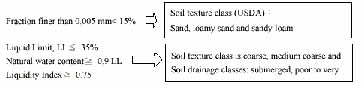
Liqefiable soils can be identified by a combination of several criteria. A simple model to evaluate soil liquefaction was developed by Wang, that is, fine-grained soils are susceptible to liquefaction if they satisfy the criteria shown in the followings: Fraction finer than 0.005mm.Í 15%.Liquid Limit(LL) Í 35%.Natural water content.0.9LL.Liquidity Index Ê 0.75. (Wang.1979)
Mterials And Methods
1. Assessment procedures:
To evaluate, classify and map the susceptibility of soil liquefaction in Taichung, Nantou, Changhua and Yunlin's Plain regions, we use the soil information system of Taiwan, which was constructed 10 years ago by Taiwan Agricultural Research Institute, as a bases. Soil texture, soil drainage classes and available soil depth (90cm to 150cm) are the parameters available to evaluate the permanent factors of soil liquefaction susceptibility. We had to apply pedotransfer function to modify these parameters of the soil information system and meet Wang's model requirement. (Wang, 1979) The map of active faults in Taiwan (CGS, 1998) is another useful information to be used as a aggravate factor of soil liquefaction susceptibility. The nearer the fault lines site is, the more opportunity to liquefy, when the energy of emitted waves is sufficient. MAPINFO geographic information system software was used as an analysis tool. We map the susceptibility of soil liquefaction in Taichung, Nantou, Changhua and Yunlin's Plain regions, and the maps were verified their reliability in the soil liquefaction areas..
2. Pedotransfer of soil data:
The objectives of the identification of liquefiable soil are granulometry and Atterberg limits etc, which have some relationship with soil texture and soil water content characteristics. But these two factors are very difficult to measure. Pedotransfer fuctions (PTFs) are used to transfer the quantitative criteria to the easily measured soil properties we have in the soil information system. So we had to transfer the Wang's criteria of the soil liquefaction into the parameters of the soil information system for further analysis. The followings are pedotransfer Functions (PTFs) for soil liquefaction:
Because the effective depth of the shallow foundation construction is about one meter to five meters, we chose the soil texture of the deepest layer (90cm to 150cm) which the soil information system of Taiwan available.
3. Rating the soil liquefaction susceptibility:
Liquefiable soils are rated and classified by the criteria of soil texture and drainage class as following table:
Table 1. Rating table of soil liquefaction susceptibility (for shallow foundation construction)
| Soil Liquefaction Susceptibility Rating Class | Coarse texture (sand, loamy sand, etc) | Medium-coarse texture (sandy loam, very fine sandy loam, etc) | Medium texture (silt loam, loam, etc) | Medium- fine texture(clay loam, silty clay loam, stc) | Fine texture(silty clay, clay, etc) | Gravelly |
| Well to moderate-well drainage | 2 | 3 | 4 | 5 | 5 | 5 |
| Imperfect drainage | 1 | 2 | 3 | 4 | 5 | 5 |
| Poor to very poor drainage | 0 | 1 | 2 | 3 | 4 | 4 |
| Submerged | 0 | 0 | 1 | 2 | 3 | 3 |
1. Class 1:more than 90% liquefaction vulnerability.Class 2:more than 70% liquefaction vulnerability.Class 3:more than 50% liquefaction vulnerability.Class 4:more than 30% liquefaction vulnerability.Class 5:no liquefaction vulnerability.
2. If the site in the faults buffer zones(10Km wide) increases 1 class..27
Results And Conclusions
Because liquefaction only occurs in saturated soil, its effects are most commonly observed in low-lying areas near bodies of water such as rivers, lakes, bays, and oceans. Parts of Taichung, Nantou, Changhua and Yunlin's Plain regions belong to these kinds of landscapes. Tzo-Sui Alluvial Fan covers the most area in this region. Tzo-Sui River had changed its water way several times in the past two hundreds years, so many abandoned channels spread around this region.
Taichung, Changhua and Yunlin plains are also nearby the seashores, these lands have a high potential of soil liquefaction. Taichung Port and wharf facilities are located in areas susceptible to liquefaction, and have been damaged by liquefaction in 921 Chi-Chi earthquake. On level ground, during and after an earthquake, the flowing pore-water rises quickly enough, it can carry sand particles through cracks up to the surface, where they are deposited in the form of sand volcanoes or sand boils. (Kramer, 1996) The buildings and houses on the abandoned river channel are tilt due to soil liquefaction. These phenomena have been observed around the riverbeds and the fields in the Taichung, Changhua and Yunlin plains.
We used Wang's model to evaluate soil liquefaction. Soil particle size and soil water contents are the two major factors concerning soil liquefaction in this model. The criteria of fraction finer than 0.005mm.15% means that the part of finer than coarse silt particles is not more than Í 15% in the soil. The pedotransfer function can be changed this quantitative criteria to that the soil belongs to coarse texture (sands, loamy sands and sandy loams in USDA soil textural class). By the same way, Liquid Limit(LL) Í 35% also indicates that the soil belong to coarse grained soil. Because the coarse grained soil has a low liquid limit. Natural water content Ê 0.9LL and Liquidity Index Ê 0.75 indicate that the coarse soils have a high water content.
Sands were considered to be the only type of soil susceptible to liquefaction, but liquefaction has also been observed in gravel and silt. (Kramber, 1996) So the different soil texture has the different sensitivity of soil liquefaction. Soil drainage classes can indicate the different levels of soil water contents, which can be used to evaluate the sensitivity of soil liquefaction, too. So in this study, we classified the soil texture classes into five groups and soil drainage classes to four groups, as Table 1. We rated five classes of the soil liquefaction susceptibility for the shallow foundation construction by these two factors. Because the site near the active fault lines has more energy of emitted waves when earthquake occurs, so if the site under the active fault 5 Km buffer zones, the rate increase one class. In this study, we evaluated, classified and mapped the susceptibility of soil liquefaction in disastrous regions based on three categories in soil information. The map was further verified the reliability in earthquake areas. Most of the boundaries of the soil liquefaction susceptibility units match the soil liquefaction regions. The.reliability of the assessment of soil liquefaction susceptibility is very high. The information provided here could be very helpful in the developing plan for evading soil liquefaction hazard.
There are basically three possibilities to reduce liquefaction hazards when designing and constructing new buildings or other structures as bridges, tunnels, and roads. The first possibility is to avoid construction on liquefaction susceptible soils. The maps we drew can be used as a reference to determine the liquefaction susceptibility of a soil. By characterizing the soil at a particular building site according to these criteria one can decide if the site is susceptible to liquefaction and therefore unsuitable for the desired structure. If it is necessary to construct on liquefaction susceptible soil because of space restrictions, favorable location, or other reasons, it may be possible to make the structure liquefaction resistant by designing the foundation elements to resist the effects of liquefaction. The third option involves mitigation of the liquefaction hazards by improving the strength, density, and/or drainage characteristics of the soil. This can be done using a variety of soil improvement techniques. (EERI,1997)
References
- ASTM 1958. Procedures of soil testing, Philadelphia.
- Central Geological Survey, MOEA 1998 Map of Survey of the active faults in Taiwan. Central Geological Survey Repot No.10, Taipei, Taiwan. (In Chinese).
- EERI 1997. Adopted from www.eeri.org/EQ_Basics
- Hillel D. 1980. Fundamentals of soil physics., Academic Press, NY., Pp.347-351.
- Kramber 1996. Adopted from"www.ce.washington.edu/~liquefaction".
- McCarthy, D.F. 1997. Basic Geotechnics., (5 th ed.)., Prentice Hall, New Jersey., Pp.73-78.
- Monge, O., D. Chassagneux and P. Mouroux 1998. Methodology for liquefaction hazard studies: new tool and recent applications. Soil Dynamics and Earthquake Engineering. 17(1998):415-425.
- Siderius, W.1995. Introduction to pedotransfer. Lecture Notes., International Institute for Aerospace Survey and Earth Sciences., Enschede, The Netherlands.
- USDI 1990 Earth Manual. Second edition. Bureau of reclamation, U.S. Department of the Interior, Pp.25-29.
- Wang, 1979. Adopted from "www.ce.washington.edu/~liquefaction".