| GISdevelopment.net ---> AARS ---> ACRS 1999 ---> Water Resources |
Identifying the morphological
changes of a Distributary of the ganges in response to the Declining flow
using remote sensing
Maminul Haque Sarker,
Mohammad Mostafa Kamal and Dr. Khaled Hassan,
EGISII, House # 49, Road # 27, Banani, Dhaka, Bangladesh
Phone: 880-2-881570-2, Fax: 880-2-883128,
E-mail: msarker@cegisbd.com
Keywords: Planform, Remote Sensing, Erosion,
Sinuosity, Migration RateEGISII, House # 49, Road # 27, Banani, Dhaka, Bangladesh
Phone: 880-2-881570-2, Fax: 880-2-883128,
E-mail: msarker@cegisbd.com
Abstract
Cartographic evidence (Rennell, 1776) shows that the Gorai River has been a major distributary of the Ganges river system since at least 200 years ago. It was a perennial river until the end of the last decade. The Gorai River carries almost 8 to 12% of the discharge of the Ganges River. This river is the main source of fresh water inflow into the southwest region of Bangladesh. The importance of this river varies with time and is governed mainly by the planform of its off-take with the Ganges River. The Farakka Barrage inside India, 18 km upstream of the international border, became operational in 1975. Since then the barrage has been diverting a substantial amount of dry season flow of the Ganges River through the Hoogly River and has thus initiated an irreversible process of deterioration of the Gorai River flow.
In response to the changes in the hydraulic regime, morphological characteristics of the river have been changing as well. Changes in planform characteristics have been addressed in this study using three sets of Landsat images (MSS-1973, 1984 and TM-1987) supported by hydrologic data. The images were classified with unsupervised classification and knowledge based thresholding to produce land, sand and water classes and the time series data was analyzed to characterize erosion, accretion and planform changes. The changes of sinuosity, rates of bank erosion and meander migration were derived from the image analysis. These were found to relate to the changes in the hydraulic regime. Morphologically, the river can be characterized into five distinct reaches. Response of each reach is different in magnitude and is mainly governed by physiographical characteristics and distance of the reach from the off-take. The images of low resolution (80m x 80m to 30m x 30m) only can be used to identify the morphological changes of dynamic reaches of the river, rate of changes of different parameters of which are in the scale of tenths to hundredths of meters. Using the images, it was also possible to derive tools for predicting the meander bend cutoff, bank erosion and accretion rate and changes of sinuosity.
Introduction
As it has done for most of the Holocene, the Bengal Delta is continuing to evolve. Much evidence is available of the changes that have taken place in the delta over the past few thousand years with the changes of base level (Umitsu, 1990; Goodbred, 1998). Rennel (1776) map give evidence that the main flow of the Ganges was following the present course of the Arial Khan River and the Gorai River was one of the main distributaries of the Ganges River. After the avulsion of the Jamuna River from its course along the eastern side of the Pleistocene Madhupur tracts to its present course, the combined flow of the Jamuna and Ganges moved further in the southeast direction and followed the present course as Lower Meghna (Figure 1).
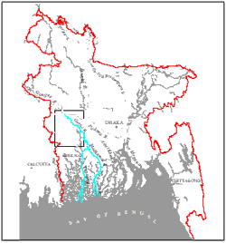
Figure 1 Map of Bangladesh showing the study area
A recent study (EGIS, 1999) shows that during the last two and a half decades the annual flow volume of the Gorai River is declining. By using remote sensing technology an attempt has been made to identify the characteristics of the morphological changes of the river in response to this reduced flow volume. The understanding on the response of the river can be used to predict the changes of the river morphology in the coming decades. This study was carried out within the framework of Environment and GIS Support Project for Water Sector Planning (EGIS II) a project of the Ministry of Water Resources of Bangladesh.
The Ganges River
The average flood discharge of the river is approximately 50,000 m3/s. The discharge is mainly contributed by the snowmelt of the Himalayas and monsoon rainfall. In general, the flood peak occurs between the end of August and early September. The bed material of the river consists of fine sand. The river is very dynamic and the channel of the river shifts between meandering and braided.
Before mid 1970s the river flowed without any major intervention along its course. Through the implementation of the Farakka Barrage in 1975, India started to divert a part of dry season flow of the Ganges River through the Hoogly River. During the post-Farakka period major changes have occurred in the dry season flow, especially between January and May. During the pre-Farakka period the minimum monthly average flow was 1,500 m3 /s. The recorded minimum monthly average flow was 170 m3 /s in April, 1995 (EGIS, 1999). However, the post-Farakka flood flows found to be of the same as the pre-Farakka flood flows.
Delft Hydraulics/DHI (1996) identified an important change in the duration of the flood recession between the pre- and post-Farakka periods. They observed that the period of the flood recession, which is very much relevant to the dry season flow of the Gorai River, has been reduced to half of its post-Farakka period. Delft Hydraulics/DHI and Halcrow (1993) both suggested that quicker recession might not leave sufficient time for the river to scour out a natural low water channel that used to maintain the perennial flow into the Gorai.
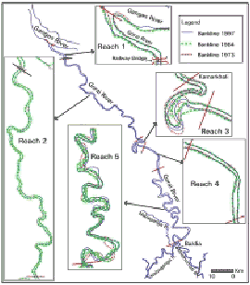
Figure 2 Different reaches of the Gorai River
The Gorai River
The Gorai River is the largest distributary of the Ganges River in Bangladesh. The average flood flow of the river is 4,500 m 3 /s. The annual average sediment transport is about 50 Mtons (million tons) in which about 40% are fine sand and the rest amount consists of silt and clay.
Discharge records from mid 1940s to mid 1970s at the Gorai Railway Bridge gauging station, show that the off-take closed in the dry season only on two occasions in the 1950s. Adams (1919) also describes the cyclic improvement and deterioration of the mouth of this river and other distributaries.
However, due to the reduced dry season flow and the quicker recession of floodwater in the Ganges in the post-Farakka period, dry season flow through the Gorai was affected significantly. Since 1988, the Gorai River began to close completely for some times during the dry season every year. Annual flow volume during the post-Farakka period also shows a clear declining trend (Fig. 3). The wet season flows have also been declining over the same period (Fig. 4).
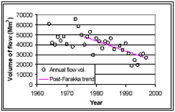
Figure 3 Changes of annual flow volume of the Gorai River
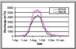
Figure 4 Daily average discharges of the Gorai River at different periods
Remote Sensing and Hydrologic Data Satellite images are mainly used to identify the morphological changes. On the other hand hydrologic data are used to show the relation between the changes of morphological parameters with the changes of hydraulic regime. The description, sources and processing methods of the data are presented below.
Images Used and Processing Methods
Dry season remotely sensed satellite data were used for a planform analysis. Landsat MSS and TM images of February 1973, February 1984 and January 1997 were organized for analyzing the meandering bend migration, erosion-accretion and sinuosity of the Gorai River.
Processing and analysis of the satellite images were performed using the computer facilities of EGIS. ERDAS Imagine 8.3.1 software was used for analyzing of the images and NT ARC/INFO 7.1.2 was used for vector data analysis. All the digital satellite data were pre-processed to remove data errors and anomalies. The images were then georeferenced and projected to the Bangladesh Transverse Marcator (BTM) Projection system. For each date two scenes of Landsat images were mosaicked to make a seamless image covering the study area.
Hydrologic Data
Time series discharge data (1964-1997) measured by Bangladesh Water Development Board in the Gorai River at Gorai Railway Bridge gauging station were used in the study.
Bankline Delineation
The images were initially classified into Land, Sand and Water. Sand class contains the sandbars during the dry season, which becomes part of the riverbed during wet season. Therefore, banklines were delineated considering both the sand and water class within the rivers. Finally the banklines were edited and refined through onscreen editing keeping the image as backdrop.
Reach Delineation
The Gorai River, whose present length is 199 km, could be divided morphologically into five distinct reaches (Figure 2). Superimposing of the bank lines derived from satellite images of 1973, 1984 and 1997 provide the impression of the characteristics of the reaches of the river. The upper reach, from the offtake to the Gorai Railway Bridge, is the widest and almost straight reach. The next reach, from the Gorai railway bridge to Kamarkhali is characterised by a mixed meander pattern that has remained remarkably stable for several decades (Halcrow, 1993). The following reach is the Kamarkhali bend, which appears to be a permanent feature and makes the flow double back twice within just 20 km (Figure 2), causing considerable energy loss. Although the bends have stayed in the same location since 1860, the loop has grown, cut off and grown again. Because of its complicated shape and behaviour, during the planform study, this reach is excluded. Downstream from Kamarkhali lie two straight stretches, which have also existed for a very long time. The last reach, the so-called "tidal lower course" is, on the other hand, extremely active and sinuous.
Response of the River
River Bed Aggradation
In the post Farakka period, average thalweg depths of the Reach 1 and first 20 km stretches of the Reach 2 have been reduced by approximately 4 m and 2 m respectively (Halcrow, 1993). Further downstream, the reduction of the depth along the river is less significant. With the reduction of the depth, Reach 1 increases its width by approximately 100 m, while the increase of width of Reach 2 is not considerable.
Migration of Meandering Bends
The migration of meandering bend is defined here as the changes of location of the point of highest curvature of a bend from one period to the other. Migration rates (m/year) have been obtained by using the bank lines derived from the images for two different periods (Figure 5, Table 1). When compared with other reaches of the Gorai River, Reach 5 is extremely active. The migration of meandering bends in reaches 1, 2 and 4 are very slow due to the river’s incision into the consolidated high Ganges floodplain. In extreme cases, the rate of bend migration is within few meters per year. Therefore, it is difficult to estimate the migration or bank erosion rate of these reaches with the help of satellite images whose resolutions are 80 to 30 m. The low Ganges floodplain is less consolidated and that is probably the main reason why the Reach 5 of the Gorai is very dynamic. In Figure 5, the migration rates for different periods (1973-84 and 1984-97) and their movement directions are presented. Inspecting the figure and tables, it can be concluded that the migration rate has slowed down and the rate is lower against the terrain slope. Slowing down of migration rate can be attributed mainly to the reduction of annual flow volume (Table 1).
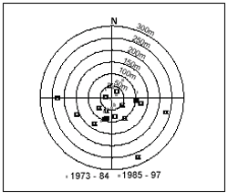
Figure 5 Migration rate and direction of meandering bends of the Gorai
Bank Erosion and Accretion
The definition of the terms bank erosion and accretion as used here is illustrated in Figure 6. Like the bend migration, in Reach 5 the erosion and accretion rate is also quite high (Table 1). The bank lines as derived from satellite images of 80 to 30 m resolution. Therefore, potential of errors in estimating the erosion and accretion is inherent. Areas of erosion and accretion only in Reach 5 of the Gorai River is presented in ha/km/year in the table. Similar to bend migration, in the period 1973 to 84, the river was more active than it was during the period 1984-1997.
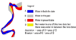
Figure 6 Area of erosion and accretion as seen in an over lay of channels of two dates.
Table 1 Changes of meandering bend migration, and erosion and accretion rate in response to the changes of annual flow volume
| River | Period | Av. Annual flow volume (Mm 3 ) |
Meandering bend migration rate (m/yr) |
Erosion (ha/km/yr) |
Accretion (ha/km/yr) |
| Gorai Reach 5 |
1973-84 | 46,654 | 110 | 2.50 | 3.10 |
| 1984-97 | 32,708 | 72 | 2.00 | 2.00 |
Sinuosity
Sinuosity is the ratio between actual length of a reach of the river and the straight length of the reach along the terrain slope. The length of the Kamarkhali bend is oscillating and sinuosity has been changing within a range of 2.75 to 3.5, while the sinuosity of the straight reach downstream of the bend is remained constant at close to 1.16. However, the changes of planform characteristics of these reaches have not been linked with the declining process of the Gorai River. Reach 5 of the river has been elongated by 16 km and the corresponding change of sinuosity is from 1.77 to 2.2 (Table 2). It could be inferred that the river reduces its slope (in response to reduction in water and sediment supply upstream) by becoming more sinuous. It endorses the observation of Adams (1919) in the other distributaries of the Ganges. He noticed that a distributary become more tortuous during their process of declination.
Table 2 Changes of sinuosity in response to the changes of annual flow volume
| River | Period | Av. annual flow volume (Mm 3 ) | Sinuosity |
| Gorai Reach 5 |
Pre-Farakka (1964-73) | 47,410 | 1.77 (1973) |
| Post-Farakka (1976-84) | 42,430 | 2.05 (1984) | |
| Post-Farakka (1984-97) | 32,520 | 2.20 (1997) |
Discussions
Applying remote sensing tools to study the morphological characteristics of the river mainly depends on the scale of the river dynamics and the resolution of the images. With images having a resolution of 80m x 80m to 30m x 30m, it is only possible to estimate the changes of morphological parameters of a river, the rate of changes of which are in the scale of tenths to hundredths of meters. The time intervals of the images were selected in such a way that during the interval period the changes are in the range of hundreds of meters. These changes are easily identifiable if bank line derived from one image is superimposed on that of another image. The error that is related to the low resolution is less for the cases of relatively high changes and vice-versa.
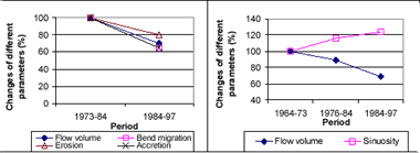
Figure 7 Changes of different morphological parameters of the Gorai River in response to the reduction of flow
First, the Reaches 1 and 2 reacted in response to the changes of the hydraulic regime and the planform of the Ganges River near the Gorai offtake. Subsequently, lower reaches reacted on the reduced Gorai flows due to the huge sediment deposits in the first 2 reaches. Due to the consolidated nature of bank materials the morphological parameters of Reach 1, 2 and 4 do not react as quickly as Reach 5. Tables 1 and 2, and Figure 7 show how the meandering migration rate, erosion and accretion rate, and sinuosity of the river reach having loosely packed bank materials reacted with the diminishing of average annual flow volume. It appears that the changes of the meandering migration rate, erosion and accretion rate are proportional and the sinuosity is inversely proportional to the changes of the average annual flow volume (Figure 7). It also suggests that Reach 5 is very dynamic and adjusts its morphological parameter rapidly with the changes of hydraulic regime.
Conclusions
Using remote sensing technology it is possible to identify the trend of morphological changes of the dynamic river reaches only. This trend can be used to predict the morphological changes in response to the declining flow of the river. It is not possible to identify the trends of less dynamic river reaches, because the older images available are of coarser resolution. However, in future this type of study can be carried out even for the less dynamic rivers using the presently available high resolution images.
It is found possible to predict (using Tables 1 and 2, and Figures 5 and 7) the morphological changes of the river reaches for the time scale of decades, because the data presented here are extracted from satellite images at time intervals of 11 and 13 years. It also appeared to be possible to predict (using Figure 5 and Table 1) a time range of occurring loop cuts in the meandering loops.
Acknowledgement
This study was carried out as part of the Environmental Impact Assessment (EIA) study for the Gorai River Restoration Project. The authors like to acknowledge all the team members involved in the EIA study.
References
- Adams, W.C., 1919. History of the rivers in the Gangetic Delta, 1750-1918. Bengal Secretariat Press, 1919, reprinted by East Pakistan IWTA, 1966.
- Delft Hydraulics/DHI, 1996. Morphology of the Gorai Offtake: special report no. 10. River Survey Project (FAP 24), Dhaka, Bangladesh.
- EGIS, 1999. Environmental baseline of the Gorai River Restoration Project. Bangladesh Water Development Board, Dhaka, Bangladesh.
- Goodbred, S.L. and Kuehl, S.A., 1999. Later Quaternary evolution of the Ganges-Brahmaputra River Delta: Significance of High Sediment Discharge and Tectonic Processes on Margin Sequence Development. Submitted to Sedimentary Geology.
- Halcrow, 1993. Morphological studies. Vol 3, Southwest Area Water Resources Management. Project (FAP 4), Dhaka, Bangladesh.
- NEDECO, 1967a. Inventerisation of the waterways. Vol II, part C: surveys of inland waterways and ports (1963-67). EPIWTA, Dhaka.
- NEDECO, 1967b. Hydrological and morphological phenomena. Vol III, part B: surveys of inland waterways and ports (1963-67). EPIWTA, Dhaka.
- Umitsu, M., 1990. Late Quaternary Sedimentary Environments and Land Forms in the Ganges Delta. Sedimentary Geology, 83(1993) pp 177-186.