| GISdevelopment.net ---> AARS ---> ACRS 1999 ---> Water Resources |
Characterizing patterns and
trends of wetland vegetation Using the Normalized Difference Vegetation
Index (NDVI)
Sunil Narumalani, Donald C.
Rundquist, Jill Maeder, Stephen Payton
Center for Advanced Land Management Information Technologies (CALMIT)
University of Nebraska, 113 Nebraska Hall
Lincoln, NE 68588-0517, USA
Tel. : 402-472-9842
E-mail: sunil@calmit.unl.edu
Keywords: Wetland vegetation, NDVI, trends,
patterns Center for Advanced Land Management Information Technologies (CALMIT)
University of Nebraska, 113 Nebraska Hall
Lincoln, NE 68588-0517, USA
Tel. : 402-472-9842
E-mail: sunil@calmit.unl.edu
Abstract
The purpose of this research was to characterize the patterns and trends of wetland vegetation for an area around Island Lake in the Sandhills of Nebraska, USA. Within the Sandhills there are numerous shallow lakes, and along their borders a significant amount of wetland vegetation growth has been observed. In this study the Normalized Difference Vegetation Index (NDVI) was used to examine its variation across different terrain features within the landscape. Landsat MSS data acquired between 1979 and 1989 during May-October (growing season) were used to derive NDVI values for selected 5x5 windows at specific locations. These windows represented a marsh area, wet meadow, sand dune slope, and sand dune top. NDVI trends over the 11-year period were determined and average NDVI values along with standard deviation were computed for each year. The highest mean NDVI was recorded for the marsh, while the lowest occurred on the dune top. Results also showed that the marsh was prone to higher variation in NDVI from year-to-year than any of the other terrain types.
Introduction
It has been well documented that wetlands are an important natural resource because they assimilate pollutants, provide flood control, and serve as breeding, nursery, and feeding grounds for a variety of fish and wildlife (Odum, 1989). Remote sensing offers a means by which wetland environments can be monitored and analyzed (Work and Gilmer, 1976; Jensen et al., 1991). In addition, through the use of historical aerial photography and satellite imagery (e.g., Landsat MSS, TM), it is possible to perform a long-term analysis of changes in wetland areas and evaluate any patterns or trends that may be observed. This research focuses on using a historical archive of Landsat Multispectral Scanner (MSS) data and analyzes the variations in the NDVI over the different terrain characteristics of the landscape.
Study Area
The study area for this project was Island Lake, which is located in the western portion of an area known as the Sandhills region of Nebraska in the U.S. (Figure 1). The Sandhills region covers approximately 57,000 km2 and is comprised of stabilized sand dunes modified by deflation hollows, small shallow lakes, marshes, and subirrigated meadows (Rundquist et al., 1985). Lying practically in the center of the North American continent, the Sandhills fall in a semi-arid climatic zone. Precipitation in the area ranges from 63.5 cm in the east to 40 cm in the west, with very little of it resulting in surface runoff because of the sandy soil.

Figure 1. Location of Island Lake study area and the four topographic sites selected for analysis.
Methodology
A total of 57 Landsat MSS scenes (subset for Island Lake) from 1979-1989 were selected for this research (Table 1). All data were geometrically rectified to the Universal Transverse Mercator (UTM) projection, and registered to each other. Four areas representing various facets of the topography within the area surrounding Island Lake were selected. These represented
- marshland (i.e., wetland area);
- wet meadow;
- dune slope; and
- dune top.
Table 1. Dates of Landsat MSS imagery used to evaluate NDVI trends for Island Lake.
| 1979 | 1980 | 1981 | 1982 | 1983 | 1984 | 1985 | 1986 | 1987 | 1988 | 1989 | |
| May | 5/01 5/19 |
5/04 | 5/14 5/30 |
5/04 | 5/07 | 5/20 | |||||
| June | 6/25 | 6/11 6/29 |
6/06 6/24 |
6/28 | 6/21 | 6/15 | 6/02 6/18 |
||||
| July | 7/16 | 7/11 7/30 |
7/16 | 7/07 | 7/17 | 7/04 | 7/10 7/26 |
7/23 | |||
| Aug | 8/01 | 8/04 8/22 |
8/08 | 8/10 | 8/11 | 8/13 8/29 |
8/8 | ||||
| Sept | 9/06 9/14 9/24 9/25 |
9/18 9/27 |
9/09 | 9/03 9/19 |
9/25 | 9/12 9/28 |
9/25 | ||||
| Oct | 10/02 | 10/14 | 10/10 10/16 |
10/14 | 10/27 | 10/24 |
Results
All topographic sites exhibited the typical pattern of a vegetation phenological cycle (Figure 2). Low NDVI values were observed during the early part of the growing season (May) and achieved full-growth potential in July/August, prior to subsiding in late September through mid-October. The marsh and wet meadow areas had the highest NDVI values (e.g., 0.615 for marshland in 1987), when compared to the dune slope and dune top. Marshes and wet meadow are covered with lush vegetation cover, and exist in sharp contrast to the sparsely vegetated uplands (dunes). This is the result of a “dynamic interaction between climatic, hydrologic, chemical, and biological processes” (Gosselin et al., in press). In many interdune valleys the water table intersects with the valley floor thus resulting in the formation of inland fresh marshes and wet meadows. Conversely, in upland areas, depth to groundwater is greatly increased, and the sandy soils cause rapid infiltration of any precipitation. This results in approximately 30-40% vegetation cover on the dune slopes and dune tops, dominated mainly by mixed prairie grasses.
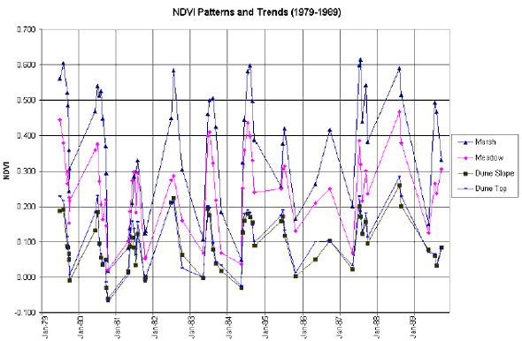
Figure 2. NDVI patterns and trends observed after analyzing 57 images during the growing seasons from 1979 to 1989. The x-axis represent Julian day for a given year.
Note the seasonal growth pattern for each year.
The mean NDVI values allow an inter-annual comparison of variations in NDVI (Figure 3). For the most part, the mean NDVI fluctuates less than 0.100 from year-to-year for each topographic feature. Notable exceptions include the marsh in 1981 and a dramatic increase in NDVI observations in 1988 for all sites. The potential reason for the marsh mean NDVI for 1981 plummeting to 0.200 was high quantities of rainfall received during the peak of the growing season. For example, precipitation recorded during the 15-day period prior to image acquisition on 30 July 1981 was 3-inches, and the Standard Precipitation Index was 2.20. Excessive rainfall quantities would temporarily raise water levels, thus concealing the wetland vegetation, which in turn would lower the NDVI values.
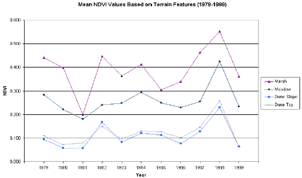
Figure 3. Mean NDVI values recorded for various terrain features within the study area
Increases in mean NDVI for all terrain features was attributed to the fact that only two images were acquired for 1988. Both images were acquired in August, which is generally considered the peak of the growing season. The images were spaced 16-days apart (August 16 and 29), and high NDVI values were recorded for both dates (0.590 and 0.515 respectively). Consequently, the mean NDVI was comparatively high. The paucity of data for 1988 was also reflected in the standard deviation observed for that year (Figure 4). In most other years, the variation in NDVI for marshland was the highest amongst all other topographic features. This is attributed to the seasonal changes in canopy cover in a densely vegetated area. During the early part of the growing season, more water is visible, thus lowering the NDVI. As vegetation growth accelerates, and canopy closure occurs, the increased near-infrared reflectance would lead to higher NDVI values.
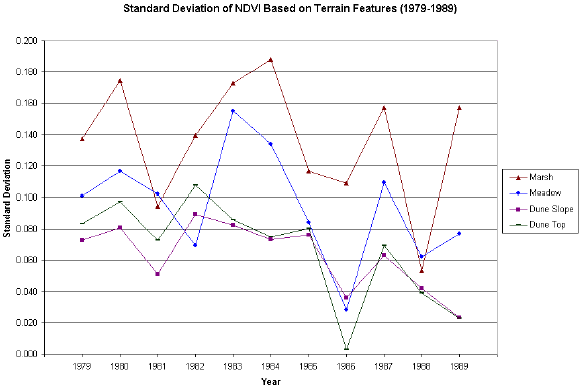
Figure 4. Variations in seasonal NDVI values for each of the four topographic locations.
Conclusion
Fifty-seven Landsat MSS images spanning an 11-year period were analyzed for trends and patterns in a wetland area and its surrounding terrain. The NDVI was computed for each image and fundamental statistical procedures were implemented on the observations. Because climatologic and hydrologic parameters have an impact on this environmentally unique area, location can be a key factor in defining the variability in the vegetation health and vigor.
References
- Gosselin, D. C., D. C. Rundquist, S. K. McFeeters, (in press). Remote monitoring of selected groundwater-dominated lakes in the Nebraska Sandhills. Journal of the American Water Resources Association.
- Jensen, J. R., S. Narumalani, O. Weatherbee, and H. E. Mackey, 1991. Remote sensing offers an alternative for mapping wetlands. Geo Info Systems. 4(10):46-53.
- Odum, E. P., 1989. Wetland Values in Retrospect. In: Freshwater Wetlands and Wildlife, (Eds.) Sharitz, R. R. and J. W. Gibbons. Department of Energy Conference, Report # 8603101, Washington, DC, pp. 1-8.
- Rundquist, D., G. Murray, and L. Queen, 1985. Airborne thermal mapping of a "flow-through" lake in the Nebraska Sandhills. Water Resources Bulletin, 21(6):989-994.
- Work, E. and D. Gilmer, 1976. Utilization of satellite data for inventorying prairie ponds and lakes. Photogrammetric Engineering and Remote Sensing. 42(5):685-694.