| GISdevelopment.net ---> AARS ---> ACRS 1999 ---> Topics Including Education |
Ground Truth Measurement
System Using RC Helicopter
Tianen Chen and Ryosuke
Shibasaki
Masanao Tsutsui, Kazutaka Iizuka, Koji Kajiwara, Yoshiaki Honda
Center for Environment Remote Sensing, Chiba University
1-33 Yoyoi-cho, Inage-Ku, Chiba, 263-8522, Japan
E-mail: tsutsui@ceres.cr.chiba-u.ac.jp
Masanao Tsutsui, Kazutaka Iizuka, Koji Kajiwara, Yoshiaki Honda
Center for Environment Remote Sensing, Chiba University
1-33 Yoyoi-cho, Inage-Ku, Chiba, 263-8522, Japan
E-mail: tsutsui@ceres.cr.chiba-u.ac.jp
Abstract
Ground truth measurement system using RC helicopter is very useful to measure BRDF. The helicopter is operated by human operator but it can keep its position by GPS aided hovering system. /we developed the measurement system and have done ground truth in Mongolia in the summer of 1999 and made sure the system can measure BRDF expectedly.
Introducton
To estimate vegetation amount by analyzing satellite dada, it is important to do ground truth and measure characteristics of reflection and emission on some condition of vegetation, then examine relationship between them. Especially, it can be considered that BRDF includes some information about the shape of plants, and that would be important factor when we estimate vegetation amount on earth.
It is quite difficult to measure BRDF correctly on ground truth measurement. It is ideal way of measurement to observe BRDF at a same distance from the targets on a same time, actually. But this way is very difficult to carry out.
There are many system to measure BRDF. One is small system which made with circularity pipe and it is effective when the targets are not so big. Other is big system which uses industrial heavy cars. It can keep some distance from the targets but it takes rime to measure,. Most system has problems like this.
As the result of fact, effectiveness and efficiency depend on the observation platform.
As for the observation on ground truth measurement which needs lots of time, hands, and money, it is essential to develop effective measurement system on good platform.
Therefore, in this research, we decided to use RC helicopter that can be operated with GPS aided hovering system which not need professional operator as a observation platform and promoted the development of observation system on ground truth for ideal BRDF measurement.
Purpose
We set the purpose to develop ground truth measurement system using RC helicopter which can measure BRDF at same distance from the target. Then do ground truth and examine the performance or the developed system.
RC Helicopter
This RC Helicopter which we used for this study is actually for industrial product and used for sprinkling agricultural chemicals. It has hovering system to stop any where and keep its position by using GPS it has 20 accuracy.
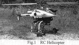
Because it can keep its position without operating by the human operator, it can reduce burden of operator, and the accuracy to decide the position had progress much more than normal helicopters.
Payload is 30kg at a 0m above sea level and it afford to carry enough machines.
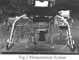
Measurement System
Measurement system is composed with the machines as follows:
- Spectrometer
It is dual port multi spectral spectrometer which can select the sensor view angle from 20 degrees to 1 degrees, And it can get both data, the data of the target and that of white at the same time.
- Digital Camera
It is 6 million pixels digital camera which can change lenses. Images is recorded into PC card and one HD card which can have 1 GB data can take picture 160 times. Also, images are saved as a loss less TIFF format
- Sensor Mount Unit
It is used two stepping motors and it can move-180 degrees to 180 degrees at horizontal level, and from -60 degrees to 60 degrees at vertical level.
- Laser range profiler
It can measure the distance up to 200 m at accuracy. GPS is exactly impossible to measure altitude from the ground ,but laser range profiler can do it and calculate footprint.
- GPS
It is the differential GPS at 20 cm accuracy. It is used SS modem for communications and it is available within 1 km.
- PC
This is assembling PC carried on CPU AMD586 133 MHz 48MB. It has the card for stepping motor inside it. It can boot from PC card, and can record the measurement data also.
- Measurement condition monitoring system
It enable to monitor on earth by CCD camera and BS system.
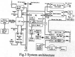
It is impossible to operate measurement system carried on RC helicopter using line. There is an another idea to let the helicopter get the data automatically with some intervals but it is not so desirable way. So this system has made to able to send three signals from ;the ground base to the measurement system. When we measure BRDF , we calculate the direction of the measurement from the center position which would be the measurement target and the present position, command to get the data, get the machine back to the right position, And get the machine to remember the position. In this way can measure more adaptively.
Ground Truth
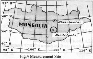
We carried ground truth measurement at grassland in Mongolia since August 3 until 31, 1999. The site for the measurement locates near Mandal Gobi, and shows the map as follows:
Mandal Gobi is the entrance of Gobi desert where there are no trees but grassland, and there are only a few small trees there.
Representative Area Measurement
About Representative Ares Measurement
When the helicopter keeps flying up and measuring, reflectance of the grassland won't change from some altitude. It means you measured enough area. So we called its area as representative area.
Fig. 5 shows Flight pattern of Representative Area Measurement
Result of Representative Area Measurement
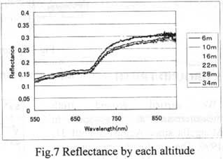
Each measurement had every 15 seconds. And one up flight takes about a 5 minutes and it will be less than 30 minutes altogether.
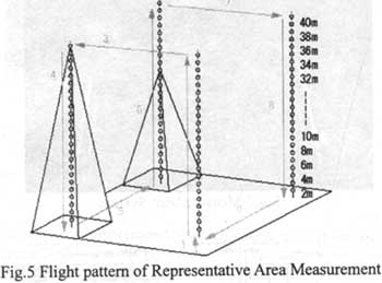
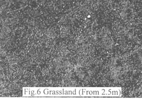
Fig.6 has taken from 2.5m altitude. Its resolution is just 1 programme and you can see the condition of the grassland precisely.
BRDF Measurement
About BRDF Measurement
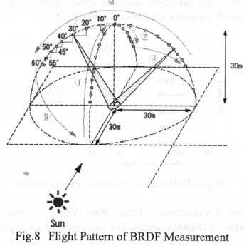
Fig . 8 shows the flight pattern of BRDF measurement.
Result of BRDF Measurement
There are 34 measurement point in one routine of BRDF measurement. It takes 15 minutes altogether from the beginning of the flight to the end. It takes 5 minutes just for one line.
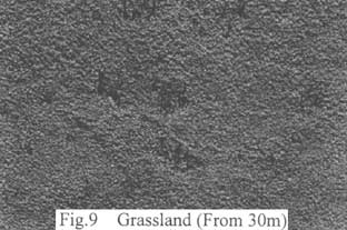
Fig. 9 is a image which taken on BRDF measurement. The sensor zenith angle was 45 degree and the distance to the target was 30m. The resolution of the image is 10mm.
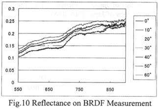
Fig.10 and Fig. 11 are the graph graph calculated from the spectrometer data. Especially, you can see the reflectance of red and IR band by each sensor zenith angle.
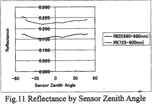
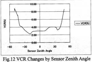
Fig. 12 shows the changes of Vegetation Coverage Rate (VCR) by sensor zenith angle. VCR has calculated from the images of Digital Camera, you can see same trend as Fig. 11.
Conclusion
In this study, it had made sure that ground truth measurement system using RC helicopter is very useful and effective system for ground truth. It also has much potential to apply other measurement in other field because it can fly place where people can't get into there.
This works has been supported by CREST(core Reach for Evolution Science and Technology ) in the research of PEPPERS (Project for Establishment of Plant Production Estimation using Remote Sensing ) of Japan Science and Technology Corporation (JST) and National Space Development Agency of Japan (NASDA).