| GISdevelopment.net ---> AARS ---> ACRS 1999 ---> Topics Including Education |
Interactive Java Applets for
Remote Sensing and GIS Education
Dennis G. Dye*,Sucharita
Gopal and junchang Ju
Department of Geography, Boston University
675 Commonwealth Ave., Boston MA 02215
Tel:(1)-617-353-4807 Fax: (1)-617-353-8399
E-mail: ddye@bu.edu
Department of Geography, Boston University
675 Commonwealth Ave., Boston MA 02215
Tel:(1)-617-353-4807 Fax: (1)-617-353-8399
E-mail: ddye@bu.edu
Abstract
We have undertaken a pilot project to develop a sample set of dynamic, interactive , Java applets to enhance teaching and improve student learning in remote sensing (RS) and geographic information systems (GIS ) courses. The applets are designed to: (1) facilitate the teaching and active learning of a particular principle, concept or technique in remote sensing or GIS , (2) employ dynamic graphics for enhanced visual representations, (3) enable user-control of applet events and key variables and parameters, (4) be accessible over the World wide Web, and (5) serve as the foundation for growing library of such applets covering a broad range of basic topics in remote sensing and GIS .
Introduction
The traditional methods of instruction in remote sensing and GIS occur in two principal modes 1) lectures and readings, typically supported by static graphics, and 2) computer laboratory sessions, in which students perform prescribed tasks using commercial software packages such as Arc View, PCI, ENVI, or Erdas Imagine, Many of the concepts and techniques in RS and GIS, such as those exhibited in three or more dimensions, can be difficult both to teach and to learn through traditional lectures and readings. The commercial software packages used in laboratory instruction are generally designed for professional or research applications rather than for teaching purposes. Although these software application are powerful, alone they can be ineffective tools for teaching the fundamental concepts in RS and GIS .
Interactive computer-based learning tools can enhance student learning by enabling active, focused learning and creative exploration at a self-determined pace (NRC,1997). The spatial and scalar nature of many RS and GIS concepts make them particularly suitable for interactive modes of learning, Currently, few educational resources are available to support student-centered, exploratory learning of basic concepts in RS and GIS . A clear need exists for interactive computer-based teaching tools that address the specific learning needs of introductory-level students of RS and GIS, but avoid the complexities associated with the large commercial software packages.
As educators, we are challenges to develop improved strategies for teaching RS and GIS to undergraduate students. Innovative computer-based instructional tools that employ dynamic graphics and interactive functionality offer potentially effective improvements, but such tools remain rare in remote sensing and GIS education. With a seed grant from the Boston University Instructional Technology Grant Program, we have undertaken a pilot project to develop and implement a sample set of interactive learning tools that are designed to facilitate effective teaching and enhance student learning in introductory RS and GIS courses.
Using Java to Develop Interactive Teaching Tools
Cross-platform programming languages such as Java provide a means for relatively quick and efficient development of interactive applets for use as teaching tools. Java applets are advantageous because they can be implemented locally in a computer lab or remotely over the Worldwide Web on virtually all major computer platforms using standard Web browsers, We are using the Java programming language to develop a sample set of four Web-based applets that are designed to support improved teaching and learning in RS and GIS . Each of the applets
- Facilitates the teaching and active learning of a particular
principle, concept or technique in remote sensing or GIS,
- employs dynamic graphics for enhanced visual representations when
addressing multidimensional or otherwise complex phenomena,
- presents highly interactive applets, enabling user-control of applet
event and key variable and parameters,
- can be accessed from any location using a browser on the Worldwide
Web,
- can contribute to a growing library of such Internet-based instructional covering a broad range of fundamental topics in remote sensing and GIS.
- Blackbody Radiation principles (RS)
- Linear Contrast Stretch (RS)
- Boolean Operations (GIS )
- Map projections (GIS )
The four Java applets that we developed in our pilot project are summarized as follows.
Applets for Teaching Remote Sensing
Blackbody Radiation Principles The blackbody radiation laws are important for a physically based understanding of radiation emission by the sun ,the earth, and objects in the earth's environment. Students often have difficulty gaining a clear understanding of the relationship between the temperature of a black body and the its emission behavior and how the various blackbody radiation laws described that behavior. We have developed a java applet to enhance student comprehension by that enabling students to relationships interactively(fig.1).
The applet presents simultaneous monitor displays of a) a data plot of the spectral distribution of radiant existence, b) the numerical value of total radiant existence, and c) the wavelength of peak radiant existence. The student can vary the temperature and emissive(assuming blackbody or gray body characteristics) and observe The simultaneous effects on the results predicts by the blackbody laws. Pre-set options are provided for solar existence, top-of-the-atmosphere solar irradiance, and the earth's radiant existence. Gray body existence can be plotted by specifying an emissivity value.
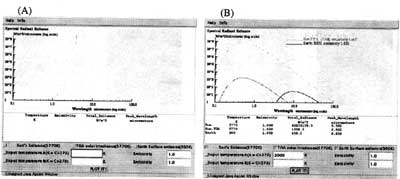
Figure 1. Applet to demonstrate blackbody radiation laws. (A) The student may select from pre-defined conditions (Solar existence, solar irradiance at the top of the atmosphere) or specify the temperature and emissivity. (B)The applet plots the associated spectral emittance pattern for the selected temperature and emissivity condition, and calculates the total existence and wavelength of peak existence.
Linear Contrast Stretch. The applet demonstrates in a comprehensive, graphical manner the concept and application of a linear contrast stretch operation in digital image processing (Fig. 2). The applet a raw, non-stretched image (input) and associated frequency distribution of digital numbers (DNs), and a line plot depicting the transformation function. The student defines of the stretch parameters (minimum, maximum output DNs). The results of the stretch operation are displayed in an adjance window, along with histogram of the output image. By interactively varying the stretch parameters the student can observe the simultaneous effects on the visual and numerical characteristics of the displayed image.
Applets for Teaching GIS
Boolean Operations Students frequently have difficulty visualizing the effect of Boolean operations on a GIS data ser, This applet employs dynamic graphics to demonstrate the application of various Boolean operations on two spatially registered GIS data layers: digital map of vegetation types and a digital map of soil types (Fig. 3 ). The student can select nesting site applied to a selected pair of vegetation and soil classes. A third map displays the results or the Boolean operation, enabling the student to inspect the input and output maps simultaneously.
Map projection. Not all college student readily have available the cognitive and spatial skills needed to understand fundamentals of map projections (Downs and Liben, 1991) Our map projection applet (not shown) goes beyond the simple display of map in shadow projection. Tissot's Indicatrix (distortion ellipse )is employed to represent the ability of various map projections to maintain correct size and angular relationships at point location. In this way student gain an improved understanding of the distortions introduced by projections.
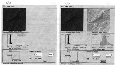
Figure 2. Applet for the linear contrast stretch operation for image enhancement. (A) Initial display showing raw image, original frequency distribution of digital numbers, transformation function, and text input boxes for stretch parameters. Histogram value can be read interactively by positioning the cursor on the graph. (B) Result displayed after applying the stretch parameters, showing the output image, histogram and transformation function.
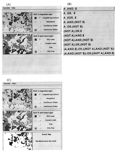
Figure 3.(A) Initial window for boolean operations applet, showing two corresponding digital thematic maps (vegetation type, soil type), and buttons forselecting classes for the boolean operation. (B) List of boolean operations from pull-down menu. (C) Display of results from A and B operation, showing map areas where irrigated agriculture and silty loam soil are coincident.
Conclusions
The project described in this paper provides practical examples of how Java of other platform- independent programming languages can be used to create interactive Web-based for enhancing the teaching and leaning of complex material in RS and GIS courses. To make our results available to interested instructors or students at other institutions, we have established a Worldwide Website dedicated to the project. Through the web site we present the sample applets and solicit feedback from users. Our web site can be found on the Web at the following URL:
http://www.crs.bu.edu/~ddye/rsgis
References
Down, R., and Liben, L., 1991. The development of expertise in geography: a cognitive- developmental approach to geographic education, Annals of the Assoc. of Am. Geographers, 81 (2):304-327.
NRC,1997. Rediscovering Geography, Wash. DC: National Academy press.