| GISdevelopment.net ---> AARS ---> ACRS 1999 ---> Poster Session 6 |
Dynamical Detection of
Eco-environment in the Upstream of the Yellow River by Remote Sensing and
GIS: A Case Study
Zeng Yongnian Ma Haizhou
Sha Zhanjiang Cao Guangchao Li Lingqin
Center for Resources and Environment Research of Qinghai-Xizang (Tibetan) Plateau Qinghai Normal University, Xining 810008
Abstract Center for Resources and Environment Research of Qinghai-Xizang (Tibetan) Plateau Qinghai Normal University, Xining 810008
In recent years, the eco-environment in the upstream of the Yellow River has been degrading due to both the global changes and the sharper contraction between human and nature. The eco-environmental problems such as grassland degeneration, sandy desertification and water erosion have seriously affected on the regional economical sustainable development. In order to protect and recovery the eco-environment in the upstream of the Yellow River, it is important to dynamically detect eco-environment with remote sensing and GIS. The region around Longyanxia reservoir is chosen as a study site, which is one of the most seriously eco-environmental degrading regions in the upstream of the Yellow River. the eco-environmental detection information system in this area is established by the remote sensing technology integrated with GIS. Based on the analysis of the multi-temporal and multi-spectral Landsat TM date with GIS, the eco-environmental changes are detected dynamically from 1987 to 1996. The result shows as manifested bellow:
- the sandy desertified land has been increased and kept a sustainable developing situation. The sandy desertified lands accounts for 71.5% of total study area, among which the very severe, severe, on going and potential sandy desertified lands are respectively 10.9%, 1.3%, 10.3% and 49%. The sandy desertified is getting more severe from 1987 to 1996. the average spreading rate of the very severe sandy desertified land is 21km2 per year from 1987 to 1996.
- The very severe and severe water erosion are mainly distributed in this area. The water erosion is one of the most serious eco-environmental problems in this area. The serious water erosion not only affects the regional eco-environment, but also endangers the security of Longyanxia reservoir.
- The land is mainly used for animal husbandry and rainfed agriculture, which are dependent on the primary productivity. The structure of land use is unitary and unreasonable, the grassland is degraded seriously from 1987 to 1996, which results in the desertificating and the decline of the land productivity.
1. Introduction
The upstream of the Yellow River is located in the northeastern Qinghai-Xizang plateau with a high altitude and cold weather. Under the high coldness, arid and semi-arid geographical environment, the fragile eco-environment is formed in this area. In recent years, the climate has been warming up and drying affected by the global changes. Due to the climate changes and the regional sharper contraction between human and nature, the eco-environment has been degrading all along, which resulted both in the serious eco-environment problems such as grassland degeneration sand desertification and water erosion and the regional economical sustainable development. In order to protect and build the eco-environment in the upstream of the Yellow River, it is important to investigate, assess the status of eco-environment and detect the changes of eco-environment dynamically. So we have carried out a project on the dynamically detecting of eco-environment in the upstream of the Yellow River and chosen the region around Longyanxia reservoir as a study site.
Longyanxia reservoir now is the largest water conservancy project built in the upstream of the Yellow River. The region around the occupies about 11500km2 and is within the coordinates of latitude 360, -360, 27' N and longitude 1010 -1010 31' E, Which is in the transitional zone between steppe and desert steppe. The climate is characterized by low, highly variable temperature and rainfall, high wind speed and frequency, high evaporation losses. The mean annual summer temperatures range from 120 C to 200 C and the mean annual winter temperatures drop to -120 C. the mean annual rainfall varies from 311-402 mm. The region has dominantly textured sandy soils which generally have low inherent fertility status, poor water holding capacity and low in organic matters. Due to fragile eco-environment as well as injudicious use and the overexploitation of natural resources, hectares of pastures have become highly degraded, which has distributed the ecological balance and as a consequences the sandy desertification spreads quickly and water erosion has intensified. The region has become one of areas where the eco-environment has been seriously degrading in the upstream of the Yellow River.
2. Methodology
Geographical information system (GIS) increasingly is being employed for wide range of environmental application, which involve integration and analysis of large amounts of spatial data of different scales. GIS is considered an appropriate technology to perform this task. In addition, large amounts of data available from remotely sensed data are being used successfully in environmental application. Based on the main eco-environment problems in the region around Longyanxia reservoir, using remote sensing integrated with GIS, the environmental detection information system has been established. The system has been successfully implemented in an operation application for eco-environmental change detection.
2.1 Eco-Environmental classification system
In order to derive information of eco-environmental changes from remotely sensed data efficiently, the features of eco-environment in high coldness, arid and semi-arid area is analyzed. Among the eco-environmental problems exited in study area, the sandy desertification is the major one, with which other eco-environmental problems have some relations. According to it and the interpretation capacity of remotely sensed TM imagery, a regional comprehensive environmental classification system is built (Figure 1), which is adapted to extraction of eco-environmental information from remotely sensed data. Based on this multi-level eco-environment environmental information, the multi types of environment such as sandy desertification, grassland cover and landuse can be derived easily. Using this system, the effect on classification results affected by spectral confusion of eco-environmental types can be reduced efficiently.

Figure 1 The eco-environmental classification system
2.2 Data acquisition
The multi-temporal and multi-spectral Landsat TM data are applied for detecting changes for eco-environment dynamically. The TM data are obtained under good atmospheric conditions. Bands 1, 2, 3, 4, 5, and 7 are used for the classification. The size of Landsat TM pixels is approximately 30 by 30 meters. The acquisition data for the study area are 1986 and 1996 respectively.
The data for regional physical environment and so economic are also acquired. Some of them are thematic maps in large scale, others are data derived from GIS. These data are used for the object classification.
2.3 Detection procedure
The detection procedure of the eco-environmental changes is designed as follow (figure 2):
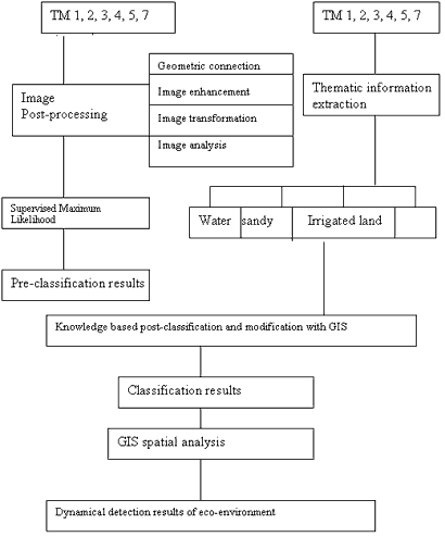
Figure 2 The detection procedure
The image are geometrically corrected by identifying ground control points in the original imagery and on the reference topographical maps and then quadratic polynomial transformation equations are applied. Subsequently, the images are resampled by applying the nearest neighbor algorithm. The root mean square (RMS) error for this transformation is less than 0.3 pixel (9m).
The supervised classification is executed using the maximum likelihood classification algorithm, supported by visual interpretation, the application of post-processing techniques and the image information analysis. The TM original bands 3, 4, and 5 are selected as classifications bands.
Classification results are affected by spectral confusion of eco-environment types and mixed pixels. Some types are mixed. This is because the supervised maximum likelihood classification is based solely on spectral observation and generally insufficient to meet the needs of regional study. Therefore, a post-classification technique with GIS is used to improve the classification accuracy. Thematic information that is mixed in the pre-classification results is extracted from remotely sensed data. Then the comprehensive various information is merged in GIS. Through knowledge-based post-classification and modification with GIS, the accurate of pre-classification results is improved efficiently.
Following the classification, the spatula analysis with multi-temporal information is applied to detect the dynamical changes of eco-environment in the region around Longyanxia reservoir.
3. Results and Discussion
Significant eco-environment changes have taken in the upstream of Yellow River from 1987 to 1996. Changes under major eco-environment systems over time and space are discussed separately.
3.1 Sandy desertification
The sandy desertified land has been increased and kept a stable developing situation in all overall statues. The results reveal that the sandy desertified lands account for 17.5 per cent of total study area, among which the very severe, severe, on-going and potential sand decertified lands are 10.9, 1.3, 10.3 and 49 per cent respectively (table 1). The sandy desertification is getting severe from 1987 to 1996 (figure 3). In nearly one decade the nearly desertification process has kept on intensifying in overall study area, although there are some reversed situation in parts of the area. The very severs sandy desertification land has quickly spread at an average rate of 21 km2 per year from 1987 to 1996.
| Types of sandy desertification | Area of sandy desertified land (km2) in 1987 | Area of sandy desertified land (km2) in 1996 | Changes of area (km2) |
| Very severe | 1058.2976 | 1247.4120 | 189.1144 |
| Severe | 181.3191 | 152.2160 | -29.1031 |
| On-going | 1268.1072 | 1182.5772 | -85.5300 |
| Potential | 5729.0555 | 5634.1824 | -94.8431 |
The results reveal that the major factors responsible for such changes are overgrazing natural pastures and overexploitation of land resources. Other factors are frequent droughts, windily weather, sparse vegetation cove and a plentiful supply of sand. The excessive human activities play an important role in the changes of sandy desertification.
3.1 Land use
The structure of land use is unitary and unreasonable. The results reveal that the land use patterns mainly consist of animal husbandry and rainfed agriculture, which are mainly dependent on the primary productivity. The areas under grassland, non-irrigated land and sand occupied respectively 80%, 4.8% and 10.9% of total study area (table 2). The grasslands with high and middle percentage of cover have degenerated. The areas of them have declined by 5 per cent and 3.1 per cent respectively, while sand and non-irrigated lands have increased by 17.8 per cent and 51.8 per cent during last nine years.
| Types of land use | Area in 1987 (km2) | Area in 1996 (km2) | Area changes(km2) |
| Water | 207.3641 | 227.8636 | 20.4995 |
| Exposed rock | 19.1310 | 19.1717 | 0.0407 |
| Sand | 1058.5100 | 1247.4436 | 188.9336 |
| Marshland | 12.6667 | 15.5149 | 2.8482 |
| Non-irrigated | 362.1053 | 549.6757 | 187.5704 |
| Irrigated land | 193.3551 | 245.8826 | 52.5275 |
| Grassland with low Percentage of cover | 181.3020 | 152.0878 | -29.2142 |
| Grassland with middlePercentage of cover | 2673.4481 | 2590.1826 | -83.2655 |
| Grassland with high Percentage of cover | 6787.7367 | 6447.7965 | -339.9402 |
The results reveal that increased human population pressure has brought not only overexploitation of land resources but also overgrazing of pastures. Additionally, agriculture and animal husbandry have taken traditional extensive management. As a consequence the land productivity has decreased, which resulted the grassland degeneration and sandy decertified land expansion.
3.2 Water erosion
The results reveal that the water erosion is one of the most serious eco-environment in this area. Although the areas of very severe and severe water erosion are relatively less (table 3), they are mainly distributed in the area around Longyanxia reservoir and on the banks of yellow river and its branches (figure 5). The serious water erosion not only declined the land productivity, but also transformed plenty of sediments to the reservoir and downstream of the Yellow River. The water erosion affects the regional eco-environment, but also endangers the security of Longyanxia reservoir.
| Types of water erosion | Gentle | Slight | Moderate | Severe | Very severe |
| Area Km2 | 7951.8778 | 1741.0950 | 825.0537 | 721.3906 | 27.2887 |
4. Conclusions
The excessive human activities play an important role in degradation of eco-environment in the upstream of the Yellow River. At present the acceleration of grassland degradation is attributed to the irrational human economical activities. The sandy desertification as well as water erosion has intensified extremely, which affected the regional economical sustainable development and endangered the security of Longyanxia reservoir. So it is necessary and urgent to combat desertification and protect eco-environment in the upstream of the Yellow River.
The results show that fully using the remotely sensed data with GIS for detecting and assessing the eco-environment is one of the effective measures of quantitative research.
Acknowledgements
The research project is supported by the National Science Foundation of China Grants (No. 49561006). The authors are highly grateful to Pro.Feng Xuezhi, department of urban and resource, Nanjing University for this direction and encouragement.
References
- Chen Guodong. 1998. Some Understandings About the Eco-environmental Protection and Buildings in the Source Region of Yangtze and Yellow Rivers. Advance in Earth Sciences, 13, suppl.: pp1-15.
- Dong Guangrong, Yan Ping, Su Zhizhu. The Urgency of Research and control of Land Desertification in the Source Area of Yangtze and Yellow Rivers. Advance in Earth Sciences,: 13, suppl.: pp32-36.
- Dong Guangrong, Gao Shangyu, Jin Jiong et al., 1993. The study on the Desertification and Ways to combat it in Gonghe Basin, Qinghai. Beijing: Science Press, pp40-58.
- Li Deren, On Definition theory and key techniques of the integration of GPS, RS and GIS. Journal of remote sensing. (1): pp68-72.
- Li Deren, Gong Jianyan, Chen Xiaoling. 1998. Spatial Information Science, Technology University of Surveying and Mapping Press.
- Manfred Ehlers et al., 1989. Integration of remote sensing with geographic information system: A necessary evolution. PE&RS. 55(11). Pp-1619-1627.
- N.M Mattikalli, B. J. Devereux and K. S. Richards, 1995. Integration of Remotely Sensed Satellite Images with a Geographical Information System, Computers & Geosciences, Vol. 21, No. 8, pp947-956.
- Zhang Jianting. 1998. Probe on some Questions of GIS Integration. Remote Sensing Information, (1): pp14-18.
- Zhang Li. 1996. Theoretical and Practical View of GIS system integration. Acta Geographic Sinica, 51(4). Pp306-314.