| GISdevelopment.net ---> AARS ---> ACRS 1999 ---> Poster Session 6 |
Digital Earth and
Geo-Information Science
Lu Xuejun
Chinese Academic of Surveying and Mapping
Li Huiguo Chen Shupeng
Institute of Geography, Chinese Academy of Sciences
AbstractChinese Academic of Surveying and Mapping
Li Huiguo Chen Shupeng
Institute of Geography, Chinese Academy of Sciences
this article expounds two kinds of different functional ---- one is facing the public and the other facing the Earth Science research. Combined with the exposition of the academic system of Geo-Information Science, the relationship between Digital Earth and Geo-Information Science is discussed.
1. Introduction
"Digital Earth" was proposed by Al Gore in January 31, 1998[1]. According to his understanding, the kernel of Digital Earth can be concluded to two points: first, Digital Earth is the integration of various kinds of modern information technologies; next to make it serve the sustainable development of human society, great amounts of spatial data and information presently available should be fully integrated and fused. Apparently, it is not the problem that can be solved only by some kinds of technologies for the fusion of great amounts of the spatial information. Its solution must related to the research on the mechanism of spatial data integration and information fusion.
Early in 1994,the scientific idea of research on "Geo-Information Mechanism" has been proposed by Chen Shupeng[2]. He thought that along with modern Earth Science increasingly stressing the understanding and simulation of the interaction's mechanism among the Earth spheres under different spatio-temporal scales, the functions of Geographic Information Systems (GISs) have been transferred from the preliminary stage of data acquisition, access and database management to the advanced stage of information simulation, analysis and prediction. It is just the " Function excursion" of GISs [Chen Shupeng, 1991] what demands us to do research on the "Geo-Information Mechanism:, which establishes the foundation for the integration and fusion of large amounts of spatial data and information, and also for human being to perform a prediction from large amounts of information in a shorter time.
As a theoretical kernel of Geo-Information Science, the Geo-Information Mechanism will certainly greatly promote the building of Digital Earth. Combined the building of Digital Earth with the systematic development of Geo-Information Science, this article discusses the relationship between Digital Earth and Geo-Information Science.
2. Establishment of structural system of Digital Earth.
Gore held that Digital Earth, which possesses some kinds of three-dimensional visualization interfaces for browsing great amounts of spatial data under different resolutions, is the network information world of rapidly increasing supported by the modern information advanced science and technology. Thus it can be seen, the established of structural system of Digital Earth needs four basic conditions at least: first it needs the support of the modern information advanced technologies; next, it is must hold large amounts of spatial data; the third id the network integration of spatial data; and the forth is the visualization in scientific computing of spatial data.
2.1 Global Information Infrastructure (GII)
The purpose for building GII is to make people in different departments and organizations to produce, access, send and use information in the world wide range, and to support the development of information-services industries and application departments in information society.
GII is mainly composed of computer network server and client, network communication technique, network software operational system and network security, etc. In the Guide of Process, Management and Development of GII Standard, some standards, what urgently need to be made, hale been provided for the development of GII, including cooperation, minimization, roam, compability, security, access methods, addressing, data navigation, data format transformation, labeling, maximal transformation time control and route selection[4], etc. Undoubtedly, the building of GII depends mostly on the development of computer science and network technologies. GII provides the necessary conditions for the strategy of Digital Earth to be put in practice. It is the fundamental platform to build Digital earth.
2.2 Global Spatial Data Infrastructure
Global Spatial data Infrastructure (GSDI) is a structural system being related to the coordination, management and distribution of spatial data, including data framework, exchange standard and data exchange station. Spatial Data Framework establishes a fundamental data set of Digital Earth, including earth surveying, cadastration, digital orthographic image, digital elevation modal, hydrology, communication, boundary etc. Many data sets of other industries have been established relying on them. Spatial data Exchange Standard is made in order to determined the methods and technologies for representation, management, collection, and analysis, query, transformation of spatial data, it has settled the base for the realization of sharing of data and resources. Spatial Data Exchange Station is the workstation in wide Area Network connected by the way of electronic communication among the producers, managers and users of spatial data. Its building has provided the assurance for the running of spatial data in Digital Earth. Thus it can be seen, GSDI has provided assurance for the sharing and running of large amounts of data and resources in Digital Earth.
The establishment of Global spatial Data Framework involves the research on data classified methods, data encoding system, etc. the establishment of Spatial Exchange Standard involves the research on spatial quality spatial data exchange format standard, spatial metadata standard, etc. All these researches will further involve the research methods of Geo-Information Science.
2.3 Network Integration of Spatial Data
Network integration of spatial data is collect all kinds of data from different places and different departments through network, and to access and manage data in terms of Spatial Data Framework, in order to achieve the seamless integration of digital maps and topographic data. It actually determines the existing form of large amounts of spatial data. The network integration of geo-spatial data involves the research methods of Geo-Information Science, such as the transformation of projection and spatial scales, the metadata of spatial data, etc.
2.4 Visualization in Scientific Computing Spatial Data
The functions of Digital Earth can be divided into two kinds: one is to provide normal services from information index to products publication facing the public; the other is to provide an open laboratory facing the scientists for Earth Science research.
In recent years, the network computer has been developing rapidly. Its function of distributed computing makes distributed scientific computing possible; the network's software has basically solved some problems such as publish, query, communication of normal information and distributed computing. New type of network computing environment will allow people to browse, query and spread his data and information efficiently. The Fig. 1 shows the structural system of Digital Earth facing the public.
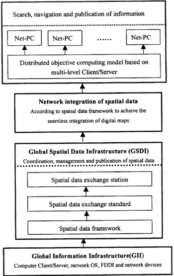
Fig. 1 the structural system of Digital earth facing the public.
Digital Earth facing the public, however, can not satisfy the need of Earth Science research, because the phenomena studied by Earth Science are greatly difficult for observing and also greatly complex for modeling and analyzing. But "Scientific Computing allows us to overcome the limitations of both experiments and theoretical sciences. Modeling and simulation will give us new insights into the data what has been collected about our planet". [Gore, 1998]. Visualization in Scientific Computing is to transform large amounts of abstract data acquired during the processes of scientific experiments and numerical computing into computer graphics and images which can be directly received by human eyes, so as the to help people to recognize the world actively and vividly[15]. Therefore, to realize the digital Earth's function facing the research on Earth Science, the Visualization in Scientific Computing of spatial data must be achieved.
- The uniform network-based platform consists of GISs and RSIPS
In recent years, the application of visualization in scientific computing in GISs and Remote Sensing Image Processing Systems (RSIPS) has been developed rapidly. Raster-based RSIPS combined with vector-based GISs has achieved the absorption of spatial features and analysis of spatial information.
At present, WebGIS with the computing pattern of distributed object based on multi-level Client/Server has been a hotspot of components to achieve the requirements of user at will, in order to solve the problems easily according to what the users think about. In addition, network-based RSIPS, by which people can directly demand images. Processing tasks from remote servers, will be developed. In a future, based on network GISs and RSIPS will together form a uniform network-based platform for spatial data processing and information analyzing. The techniques of building various spatial information systems in Geo-Information Science will provide technical support for visualization in scientific computing of spatial data.
- Spatial information fusion
Supported by the uniform network-based platform, a great deal of spatial information has been acquired. "The sticking point of fully making use of a great deal of spatial information is how to interpret its connotation" [Gore 1998]. The one of the most effective methods to interpret the spatial information is "spatial information fusion".
Spatial information fusion is to place various kinds of data into a uniform integrated environment to process in order to reduce the blur in understanding of information. It is composed of multi-source information fusion and spatial information modeling. The former, on which the research directly involves the Geo-Information Mechanism, includes multi-source Remote sensing information fusion and the fusion of Remote Sensing information and the vector-based thematic information and the vector-based thematic information supplied by GISs. The latter, which is a important research method in Geo-Information Science, is the kernel of achieving the emulation of Digital Earth systems.
- Virtual reality technology
Finally, the interfaces of visualization in three-dimension must be supplied to users for browsing the large amounts of spatial data in multi-level resolutions. The research on the three-dimensional spatial data model in Geo-Information Science is helpful for promoting the application of Virtual reality technology. Figure 2 shows the structural system of Digital Earth facing the research on Earth Science.
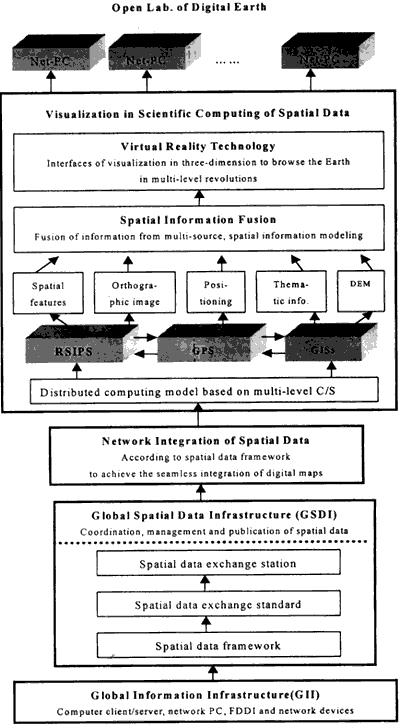
Fig 2. The structural system of Digital Earth facing the research of earth science.
3. The scientific system of Geo-Information Science
Geo-Information Science, which rose in the 1990s, is the advanced field of the research on Earth Science. Its scientific system has been established based on RS, GPS, RSIPS, GISs and the intersection of Information Science and earth system science. The objective to establish Geo-Information Science is to disclose the laws of occurrence, development and evaluation of Earth Systems from the viewpoint of the flow of information, so as to realize the prediction for the resources applications and the development of environment and society.
The scientific system of Geo-Information Science should be composed of four parts. (1) The fundamental theories they disclose the mechanisms of natural occurrence, human cognition, and computer presentation of spatial information; (2) The research methods, including the data classified method, the encoding system of spatial data, the transformation of projection, the collection of spatial data, the metadata of spatial data, spatial information modeling and spatial decision-making modeling etc; (3) The technologies for building spatial data/information systems, including the capturing system of spatial data, the spatially analyzing system and the decision-making system to geo-information; (4) The applications, including global change and regional sustainable development. The scientific system of Geo-Information Science is showed in Figure 3.
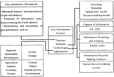
Figure 3 the scientific system of Geo-information science.
4. Relationship between Digital Earth and Geo-Information Science
The rise of the Digital Earth emphasizes the integrated application of modern advanced technologies in the fields of Computer Science, Information Science, Spatial Science, etc., and also emphasizes the network integration of great large amounts of spatial data in order to support the development of human information society. While Geo-Information Science stresses the researches on Geo-Information Mechanism and approaches of information analysis, and also stresses the building of technical systems- GPS, RSIPS, GISs and Spatial Decision-making System in order to support people to research on the laws of occurrence, development and evolution of the Earth Systems.
As discussed above, the contribution of GSDI involves the methods of Geo-Information Science such as classification, encoding system, transformation format standard, etc. the network integration of spatial data also involves the methods such as projection transformation, metadata description, etc. in Geo-Information Science, the technical systems- RSIPS and GISs together form the platform for visualization in scientific computing of spatial data. As for the fusion of spatial information, multi-source information Mechanism, and spatial information modeling is a important method in Geo-information Science.
5. Conclusions
Geo-Information Science provides the support on theories, methods and technologies for the building of Digital Earth facing the Earth Science research. On the other hand, the building of Digital Earth facing the Earth Science research will provide a new means for Geo-Information Science to research on the complex Earth systems. Undoubtedly, if combined the Digital Earth research with the Geo-Information Science research tightly, the development of Earth Science in the 21th century will certainly be enormously promoted.
References
- Gore Al. Digital Earth Understanding Our Planet in the 21st Century 1998.
- Chen Shupeng Geo-Information Mechanism: a priority research field of interdisciplinary Science Guild. 1994.
- Chen Shupeng. Information flow and cartology, Geographic exploration * the third volume * the application of Remote Sensing. Scientific Press. 1990.
- So/IEC JTC In 4889ISO/IEC: 1 GII Roadmap(version 1.0): Guideline for Evolution, Management and Development of GII Standards. ISO/TC 211 document N402, 1997.08.11.
- McCormick B.H. Defanti MD. Brown MD. Visualization in Scientific Computing Special Issue ACM SIGGRAPH Computer Graphics, 1987.21(6).