| GISdevelopment.net ---> AARS ---> ACRS 1999 ---> Poster Session 6 |
Atmoshpheric Correction and
Aerosol Remote Sensing Based on Radiative Transfer Model Computation
Lu Daren Duan
Minzheng
LAGEO, Institute of Atmospheric Physic,
Chinese Academy of Science,
Beijing, 100029, China
Abstract
LAGEO, Institute of Atmospheric Physic,
Chinese Academy of Science,
Beijing, 100029, China
The strategy of both the remote sensing of the atmospheric aerosols and atmospheric correction for quantitative retrieval of the earth surface reflectance with space-borne sensor in solar radiation waveband, i.e., from visible, near infrared to short-wave infrared waveband is discussed in this paper. This strategy is based on the quantitative analysis of the relationship between the observed parameters (apparent spectral reflectance) by space-borne sensors and the intervening atmosphere and earth surfaces, by using radiative transfer model calculation. At first, we derived an explicit parameterized expression which relates the apparent spectral reflectance with the atmospheric spectral optical depth and surface spectral reflectance, then, we suggested an iterative algorithm for simultaneous remote sensing of both atmospheric spectral optical depth and surface spectral optical depth and surface spectral reflectance. In this algorithm some empirical relationships for atmospheric spectral optical depths and surface spectral reflectance in different wavelengths, respectively, are assumed. The above algorithm can be applied to the remote sensing of relatively homogeneous surface. Second, for inhomogeneous surface, we developed an algorithm of the atmospheric spread function which is the basis of the estimation of the adjacency effect for high resolution surface remote sensing, such as small pixel size as TM, SPOT images. Based on above algorithms, we may execute the atmospheric correction for both low and high resolution remote sensing and also, in same approximation for spectral relationship of both atmospheric spectral optical depth and surface spectral reflectance respectively, simultaneous remote sensing of the atmospheric aerosols and surface reflectance can be operated.
Key words: atmospheric correction atmospheric aerosol; adjacency effect; optical remote sensing.
1.Introduction
Atmospheric correction plays an important role in quantitative remote sensing of surface parameters from space-borne (satellite) and air-borne optical remote sensing from visible, near infrared, to short-wave infrared waveband. For surfaces with low reflectance such as water surface, atmospheric scattering contributes the major part of the reflected solar radiance to the sensor than the radiance reflected by water surface. Thus atmospheric correction is consisted of the major step for ocean optical remote sensing. The another effect of atmosphere scattering is called adjacency effect, which is the contribution of background reflection to the sensor's field of view in certain target pixel through atmospheric scattering. This adjacency effect plays important role in high resolution remote sensing of inhomogeneous surfaces with big contract within neighbouring pixel.
There have been a lot of research works towards appropriate atmospheric correction. In principal, if one knows the atmospheric condition, in particular atmospheric aerosol information such as optical depth, aerosol type (which characherizes its size distribution and reflective indices), surface can be retrieved by radiative transfer model calculation for horizontal homogeneous atmosphere with homogeneous surface. For inhomogeneous surfaces, one needs to reduce the adjacency effect, which is related to radiative transfer model for horizontally homogeneous atmospheric and inhomogeneous surfaces.
In fact, in many cases, information for atmospheric condition is not available. On the contrary, atmospheric aerosol (optical depth and other parameters) as also an important task of the optical remote sensing as it plays significant role in cooling (in general) the atmosphere which may compensate the world global warning by increasing emission of trace gases. In general, dynamic monitoring of both the atmospheres which may compensate the world global warning by increasing emission of trace gases. In general, dynamic monitoring of both the atmospheric (aerosols) as well as earth surface becomes an urgent task for both earth science research and various applications. In this sense, we need to develop retrieval algorithms for simultaneous remote sensing of atmospheric aerosol's optical depth and surface reflectance.
One of the strategies to implement such as task is to use known empirical (by some other research) spectral dependence of atmospheric scattering and surface reflectance. Some investigators use dark (A(l)-0) pixel (in certain wavelength l) to derived atmospheric aerosol's optical depth (ta(l)), then by using empirical relationship to obtain (ta(l) in other wavelengths, which may be used as the basis of atmospheric correction for other non-dark surface pixels. In this approach, the basic requirement is the existence of dark pixels with enough size within remote sensing image. Inaddition, it is assumed that the distribution of atmospheric aerosols are horizontally homogeneous and empirical relationship of (ta(l) is appropriate. These last two assumptions are generally valid for finite areas. As for the correction of adjacency effect, there have been detailed discussions with preliminary success. [e.g.1,2]
Recently there have been a series of so called imaging spectrometer and multi-wavelength imagery sensor on board different earth observing satellites such as OCTS, AVHRR, POLDER on ADEOS, LANSAT/TM series, SPOT/HRV series. MODIS on EOS AM-1 etc. Data resources of spectral remote sensing are rich enough for us to search for more effective retrieval algorithm(s). In this paper, a strategy is suggested for both atmospheric correction and remote sensing of atmospheric aerosol optical depth. The strategy is based on radiative transfer model calculation. The basic procedure is at first to separate contribution then to deviate the target direct reflection from adjacency effect, procedures for these tow steps are discussed.
2. Strategy of Simulateneous Remote sensing of atmospheric aerosol optical depth and average surface reflectance.
2.1 Parameterization and separation of contribution of atmospheric scattering scattering and surface reflectance.
For horizontally homogeneous atmosphere and homogeneous lambertain surface, RT model codes such as DISORT, 6S, et al. have been widely used to obtain numerical results with enough accuracy. An approximate expression is also commonly used [3,4]
Taking rs(t,A,mo, ms, jos) = pI / m0F, Eq. (1) Can be simply expressed as the following form (omitting m0,ms,pos)
Figure 1 shows the calculated results of rs - (t,A) relationship by DISORT code, atmospheric condition is mid-latitude summer and rural aerosol of LOWTRAN7.
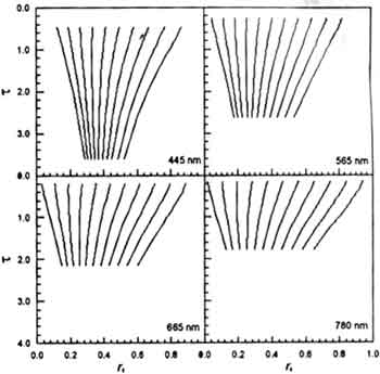
Fig.1 Relationship of rs-(t,A) each line represents rs-(t,A) relationship for fixed values of A, value of A are from 0.0 (the leftest) to 1.0 (the rightest) with interval of 0.1.
After making a series of computation with wide range of t and A and wavelength l, for specific view angles by using RT code, we may establish empirical polynomial approximation of a, b and c as
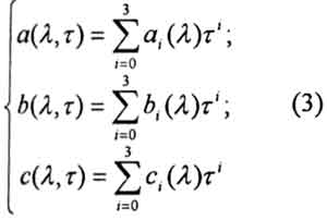
In [4] we have shown the detailed results aij, bij, and cij of these parameterization. There is very accurate fitting, the maximum error is less than 2% in most cases.
2.2 simultaneous Remote Sensing of Atmospheric Aerosol Optical Depth and Surface Reflectance.
Eqs.(2)-(4) consist of the explicit expression of rs-(t,A) relationship for different wavelength. We need complementary information of the form of spectral dependence of t(l) and A(l).
For atmospheric scattering, we may use molecular scattering ts-(l) and exponential relationship for aerosol optical depth ts-(l) as
where l0 is certain reference wavelength, where tm(l0) is known, so
for surface reflectance, we need to establish specific relationship for different classes of surface. In certain land surface such as soil and vegetation, in some wavelength interval in visible and infrared band, linear relationship is existed.
Eqs. (2)-(7) consist of basic equations for simultaneous remote sensing of t(l). In [2] we have given some numerical results for these retrieval. These equations are solved by a hybrid method.
3. Straegy of Atmospheric Correction for Inhomogeneous Surface
For inhomogeneous (but Lambertaion) surface, atmospheric correction consists of reduction of intrinsic atmospheric scattering and adjacency effect. In this case, the following approximate expression can be used [3]
Here A(0) is the reflectance of some target pixel, Ab is the average reflectance for background surface surrounding the target pixel. T(q0) is the atmospheric transmittance (direct plus diffuse) to the surface, d(qv) is the upward diffuse transmittance. Ab is expressed as the weighting integration of background surface reflectance A(L,f), L and f are distance and azimuth angle between background pixel to the center of target pixel. The weighing function D(L) is called atmospheric spread function.
In fact, the effective average area is determined by D(L).
3.1 Derivation of D(L) from R-T Model Calculation
Several investigators have given approximate expressions of D(L), [5,6]. All these expressions didn't consider function of surface reflectance. In fact, different surface reflectance result not only the different magnitude of adjacency effect but also variation of the form of D(L). Here we derive a new expression for D(L) by the following integration (refer to Fig.2).
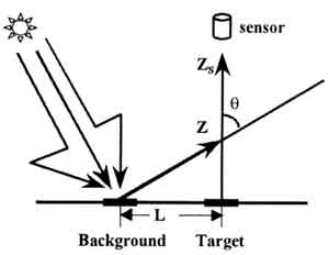
Fig.2. Schematic diagram of adjacency effect.
D2(L) is same as D1(L) except in the integration the scattering phase function P(z,q)=1 for characterizing multiple scattering as isotropic. f is the fraction determined by RT calculation. For homogeneous surface, the adjacency effect can be accurately estimated effect can be accurately estimated. Thus
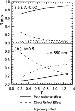
Fig.3 Relative significances of atmospheric path radiance, target direct reflection, and adjacency for homogeneous surface with different surface reflectance.
For given atmospheric and surface condition, all of r, ro, T(q0),d(qv), D1(L),D2(L) can be obtained as the function of t and A, thus value of f can be determined. In fact, We have made numerical calculation for same atmospheric model s used in section2 with different t and A. fig 3. shows the percentage of r0, r1 (target reflection), r2(adjacency effect) as function of t and A. The expression of D(L) is also valid for airborne remote when the sensor height is within the atmosphere. In this case, t is the optical depth between Z and Zs, the height of airplane. It is shown that for different t and A, path radiance and adjacency effect have different fraction.
Fig. 4 gives the example of D(L) (relative unit), it is shown that D(L) is also depending on surface reflectance. In this Figure, expression of D(L) by [6] is also given. Comparison with our results revels that for different D(L) should be used. Based on above model calculation, we can derive empirical fitting of D(L) for operational atmospheric correction. This will be done in our next paper.
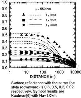
Surface reflectance with the same line style (downward) is 0.8, 0.5, 0.2,0.02 respectively, symbol results are Kaufman(6) with Ha=1.0km
Fig.4D(L) as derived by Eqs. (10)-(12) for different surface reflectance.
3.2 procedure for Atmospheric correction of Inhomogeneous Surface.
Based on discussions and derivation of previous section, we suggest the following procedure of atmospheric correction.
3.2.1 When atmospheric parameters are available
- Calculation of r0 and reducing r0 from observed apparent reflectance r.
- Derivation of average Ab(see.2.2)
- Derive D(L) for average Ab centered at each target pixel centered at (x,y) with Eq (10)-(12) of its empirical formulae;
- Reduction of adjacency effect by Eq(8) and to obtain high resolution surface reflection A(1)(x,y) with averaged Ab(x,y) as first guess of A(x,y)
- Repeat d, until|A(n+1)(x,y)-A(n)(x,y)|x,y)|< e, e is a predetermined error. Then taking final solution A(x,y) = A(n+1)(x,y).
- Follow procedures of section 2.3 to retrieve atmospheric spectral optical reflectance.
- Repeat procedures of section 3.2.1.
In previous sections, we briefly discussed the strategy of atmospheric correction and the simultaneous remote sensing of atmospheric aerosol optical depth and surface reflectance. This strategy is based on the radiative transfer of intrinsic atmospheric scattering, target surface direct reflectance, as well as adjacency effect, respectively. A new expression for atmospheric spread function D(L) is derived. Based on above analysis, we suggested the procedures to retrieve atmospheric aerosol spectral optical depth and surface spectral reflectance by using space-borne or airborne spectral images. We are using this strategy for TM's atmospheric correction.
Acknowledgment
This work was supported by National natural Science Foundation of China under the Major Project "IMGRASS" (No. 49790020) and also supported by China National High -Tech Program on Space Technology (863-2)
References
- Tanre D., et al, 1987, Adjacency effect produced by atmospheric scattering in Thematic Mapper data, J.G.R, 92(D10), 12000-12006.
- Zagolski F. and J.P. Gastellu-Etchegorry, 1995, Atmospheric Corrections of AIRIS images with a procedure based on the inversion of the 5S model, Int. J.Remote Sensign 16(16) 3115-3146.
- Tanre D., M.Herman, and P.Y. Deschamps, 1981, Influence of the background contribution upon Applied Optics, 20(20) 3676-3684.
- Lu Daren and M-Z Duan, 1998, Strategy of simultaneous remote sensing of aerosol optical depth and surface reflectance with space-borne spectrometry, Proc. SPIE, vol. 3501, "Optical Remote Sensing of the Atmosphere and Cloud" 2-11.
- McClatchey RA.A, et al, 1971, Optical properties of the atmosphere. Report AFCRL 71-0279, Environmental Research paper 354, AFRL, Bedford. MA, USA.
- Kaufman Y.J., 1984, Atmospheric effect on spatial resolution of surface imagery, Applied Optics, 23 (19), 3400-3408