| GISdevelopment.net ---> AARS ---> ACRS 1999 ---> Poster Session 6 |
Use of DSMP-OLS Images for
Early Identification of Impacted Areas due to the 199 Marmara Earthquake
Disaster
Shin Hashitera, Masayuki
Kohiyama Norio Maki, Haruo Hayashi, Masashi Matsuoka
Earthquake Disaster Mitigation Matsuoka Matsuoka
2465-1 Mikiyama, Mili, Hyogo, 673-0433, Japan
Tel: (81)-794-83-6623 Fax: (81)-794-83-6695
E-mail: hasitera@miki.riken.go.jp
Haruhiro Fujita
23-7 Hayasuzucho, Miyakonojo, Miyazaki, 855-0055
Tel(81)-986-23-6009 Fax: (81)-986-23-6009
Earthquake Disaster Mitigation Matsuoka Matsuoka
2465-1 Mikiyama, Mili, Hyogo, 673-0433, Japan
Tel: (81)-794-83-6623 Fax: (81)-794-83-6695
E-mail: hasitera@miki.riken.go.jp
Haruhiro Fujita
23-7 Hayasuzucho, Miyakonojo, Miyazaki, 855-0055
Tel(81)-986-23-6009 Fax: (81)-986-23-6009
In the hanshin -Awaji Earthquake Disaster of 1995, initial disaster response actions were delayed and ineffective due to the lack of information about the spatial distribution of damaged area. For more affective emergency responses, both national and many local governments developed damage estimation system using GIS based on social inventory database and information provided by Japan metrological agency. As in foreign countries, in the case of these earthquake disasters occurred, spatial distribution of earthquake impacted area should also be indispensable information to make international disaster assistance effective. International research and rescue team should be deployed properly to the impacted area. In addition, humanitarian aids by various organizations should be distributed properly and fairly to those who need such aids. There are only few countries in the world that have damage estimation system such as developed in Japan. It is desirable for international disaster response and relief committees to identify the location of impacted area as soon as possible as the task for their mobilization. Though there are some researches using DMSP-OLS data to investigate the change of population [3], but it is not found that those utilize DMSP-OLS data for the early impacted area estimation as disaster response. In this paper, we propse a method that can carry out the early estimation response. In this paper, we propose a method that can carry out the early estimation of the impacted area due to the Marmara earthquake in Turkey (M7.4) on August 17, 1999 by using the satellite images of DMSP-OLS.
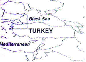
Fig.1 The analysis area
DMSP-OLS image data
It can be expected that the illumination of city lights at night will be significantly decreased after a large earthquake due to various reasons such as electricity failure, building collapses or the suspensions of commercial activities. Therefore, the significant reduction in night-light can be an indication of possible impacted areas due to earthquake disasters. The satellite image data by the DMSP-OLS may be suitable data source for the early identification of possible impacted areas, because of the availability of night-time images. In addition, it crosses any point on the earth twice a day so that we can continually observe significant reduction in night -light on a daily bases [1].
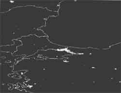
Fig.2 The optical image before the earthquake (around 11:30 pm, August 16)
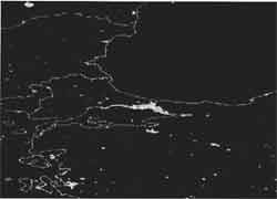
Fig.3 The optical image after the earthquake (around 11:10 pm, August 17)
Application to the Marmara Earthquake Disaster
We estimate the possible impacted of areas of the 1999 Marmara Earthquake Disaster that occurred in northwest Turkey on August 17. The DMSP-OLS data for Istanbul and neighboring regions as shown in figure 1 were obtained from NOAA/ NGDC (National Oceanic and Atmospheric Administration / National Geophysical Data Center). The night-time images before This information can be seen on EDM's web site. http://www.miki.riken.go.jp and after the earthquake are shown in Figures 2 and 3 respectively.
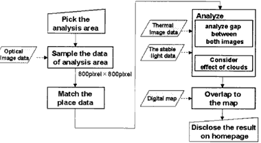
Fig.4 The flow of Publishing the estimated result
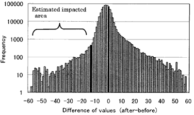
Fig. 5 Frequency distribution of different of pixel values
The step flow for the estimation is shown in Figure 4. We calculated the differences in optical sensor values before and after the earthquake in sampled area (640,000 pixels).

Fig. 5 The estimation result of impacted area
The estimated impacted area was obtained on a pixel bases as shown in Figure 5. Base on the obtained frequency distributions of the differences in the optical sensor values, the area which showed the reduction in night-light with p<0.995 was determined as significant reduction due to the earthquake disaster. The final result was distributed to the world through our web site on September 7, 1999.
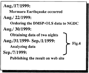
Fig. 7 The day chart
Conclusion
We analysis DMSP-OLS image data for prior and post situations of the earthquake in Turkey. The estimated impacted area spreads widely in Yalova, Kocaeli, Sakarya, Bursa, Eskisehir and Bolu provinces. These estimation results showed with a high degree of correspondence with the real damages. It is needed to conduct further examinations using the subsequent data in order to test validity and reliability of this analysis method.
In this analysis, it took three weeks since the onset of disaster to disseminate the final results, including the one week to get the relevant DMSP/OLS data from NOAA/NGDC. The entire process should be reduced to less than three days since the onset of the disaster by establishing a proper procedure of analysis and dissemination processes.
*DMSP (Defense Meteorological Satellite Program)
DMSP are the military satellites of the USA. These are in a near-polar, sun-synchronous orbit at an altitude of approximately 830 km above the earth. Each satellite crosses any point on the earth twice a day and has an orbital period of about 101 minutes, thus providing 2.7 km resolution data every six hours.
Reference
- hashitera, S., Maki, N. and Hayashi, H., (1999), "The Potential of
Using Satellite Images to Determine an Index of Recovery from Natural
Disaster: A Case Study of the Great Hanshin-Awaji Earthquake Disaster",
Proceedings of the 6th Japan/United States Workshop on Urban Earthquake
Hazard Reduction, pp. 492-495.
- Hayashi, H. and Takashima, M., (1998) "Fundamental Research about
Method for Real-time Observation of Recovery Process Using Historical
Data of Electric of the Institute of Social Safety Science No. 8, pp.
348-357 (in Japanese)
- Konami, T., Shibasaki R., and Guoxin Tan G., (1998) "Using Night
DMSP/OLS image of city Light to Estimate District-level Population
Distribution in Development Countries", Proceedings of the 19th Asian
Conference on Remote Sensing,
Q21.