| GISdevelopment.net ---> AARS ---> ACRS 1999 ---> Poster Session 6 |
Monitoring the Thermal IR
Anomaly of Zhangbei Earthquake Precursor by Satellite Remote sensing
technique
Cui Chengyu , Zhang Jinkai,
qin, Xiao, Qig, Liu Qinhuo
(institute of remote sensing Application, CAS, Beijing 100100, China)
Luo Zhuoli, Ding Jinhai, Lu Qiqi
( center of Analysis and prediction, CBS, Beijing 100036, china )
Abstract(institute of remote sensing Application, CAS, Beijing 100100, China)
Luo Zhuoli, Ding Jinhai, Lu Qiqi
( center of Analysis and prediction, CBS, Beijing 100036, china )
A process of IR anomaly changing had been detected before earthquake happened in Zhangbei area, northwest to Zhangjiakou , hebei province, during to pilot running period of the project of Fast processing system for satellite Monitoring the thermal infrared Anomaly earthquake precursor. This practice is a typical case using the satellite remote sensing technology to monitor earthquake .
Introduction
Te possibility of short-term earthquake forecast is focused for a long time, but it is still a difficult research area in al over the world. A lot of researchers are earnest to explore new techniques and methods for earthquake forecast [1-5]. In the paper we want to explore the possibility of earthquake forecast using meteorological satellite data .
A violent earthquake (602) occurred at 11:50 am : Jan 1998 in Zhagbei area, northwest to the Zhangjiakou of Hebei province. The earthquake just happened within the pilot running period of the research project Fast Processing system for satellite monitoring he infrared anomaly of Earthquake precursor. From Nov. 1 1997 to the end of Jan. 1998, we used our own system to monitor the ground infrared anomaly of the capital region (E110-120, N34-42) day and nigh. A series of processing procedures including radiate and geometric correction and the elimination of the weather effect were employed to extract the ground thermal infrared anomaly information related the earthquake form the NOAA AVHRR data. a local infrared radiant anomaly had been discovered 14 days before the earthquake. From then , 5 images showed the variation and development of the ground IR radiant anomaly prior to the earthquake. The analysis showed that the strip-liked temperature rinsing area extended to the west of Tangshan and then the to Beijing and Zhangbei are day by day . the speed of temperature rising and the scale of the anomaly are increased obviously form Jan. 5 to Jan 9. this practice is a typical case to use satellite remote sensing data to monitor the TIR anomaly precursor information of the earthquake.
Approach
1. the monitoring of earth IR anomaly information by remote sensing.
The system used in this research was developed by ourselves, which was supported by the project of Fast Processing System for satellite Monitoring the Infrared anomaly of Earthquake Precursor. This system is based on a Pentium 586 PC and equipped with input and output devices. The nodules in the system were programmed based on IDL visual language. The system was divided into imaging processing modules and special system modules. The special system module includes NOAA/AVHRR 1B data interface, radiate and geometric correction module, atmosphere correction module, ground TIR anomaly information extraction module. A background database has been established to accumulate the atmosphere temperature and earth temperature data, geological information, active fault and epicenter distribution, earth magnetic field and earth electronic field, gravity data and earth GIS data etc other data in recent ten years. The database is convenient for multi-source data comparison and analysis when we make a deduction or an explanation.
We started to develop this system in the beginning of 1996 and finished in Sept. 1997. During Nov. 11 1997 to end of Jan. 1998 the system was used to process NOAA AVHRR data for 4 times day and night to verify the system's reliability and practicality. Due to the limit weather condition, the research area was selected in Beijing and Tianshui area. The research areas were about 100*100 and 130*130. During the plot a series of method of eliminating the disturbed factors have been researched. The disturbed factors include background thermal radiations, cold and warm atmosphere changing procedures, the thermal IR anomaly in front the Taihang Mountain and Sun radiation to earth and other disturbed factors. The NOAA-14/AVHRR data acquired at night was processed and analyzed. The TIR anomaly precursor information of the earthquake was extracted.
2. Analysis on the infrared anomaly of the precursor of Zhangbei earthquake.
Zhangbei earthquake area, located in the north range of Huabei platform, includes the north part of Huabei plain, north branch of Taihang mountain range (NW) aand Yanshan mountain range (EW)(figure 1). The main faults are oriented in NNE-NE direction. There is no fault mapped on the 1:200,000 geological map of the epicenter area but one group of small NW faults in the south end of the area. There is no any historical record of the earthquake greater than 3 level in the area.
(1) The discovery of thermal IR anomaly
While processing the AVHRR data acquired in the morning, Dec. 28, 1997 to derive the ground IR radiation information, we find that a strop-like anomaly area, 100 km in length and 20-30 km in width, appeared in the west of Tangshan and extended along the NW direction (figure 2). The temperature in the anomaly area was 1-3 degrees higher than its surroundings area. The analysis of the image after the earthquake indicated that 4-6 degrees temperature anomaly area also existed in Zhanjiakou area, which was perpendicular to the background temperature field and expanded to NW direction.
(2) Extension of IR anomaly from Bohai Gulf to Zhangbei
On the color density-slicing image and temperature contour map of the morning thermal image acquired on Jan. 5-6, 1999, the thermal anomaly belt apparently run through the Bohai Gulf and ended in the Zhangbei. (The anomaly is much clearer in the thermal image of Jan. 6 1999). Along the line from Changpin to Zhangjiakou and further to Zhangbei epicenter, the IR radiant temperature increase was up to 1-3 degree. The scope of the temperatures rising can even reach up to 4-6 degrees where this strip-like anomaly belt cross the TaiHang mountain range and Guanting reservoir, (Figure 3).
In the morning of Jan. 8, the temperature rising from Bohai Gulf to Changping was strengthen and expanded southerly to Tianjin area. The temperature-rising amplitude in this area was up to 6-9 degrees. Although the anomaly belt also had the tend to extend southerly, the temperature-rising range remained between 1 to 3 degrees.
The infrared anomaly became especially clear on the image acquired in the morning, Jan. 9 1999. (Figure 4). The IR thermal anomaly belt from Bohai Gulf to Changping expanded wider and longer. The width and length were up to 200 km and 500 km respectively. On the image, there is another thermal anomaly belt, 150 km long and 30-40 km wide, in the east of Tangshan. These two anomaly belts may be related to the activity of two hidden active faults.
(3) The disappearance of the thermal IR anomaly and the following strong earthquake is evidently related. The thermal IR anomaly area, which is apparent in Jan. 9, became undistinguishable on the image of Jan. 10. At 11:50 am of the same day, the violent earthquake (6.2) occurred between Zhangbei and Shangyi. Because if the bad weather condition and the limit of the satellite passing time, no high quality data has been acquired immediately before and after the earthquake.
Conclusion and discussion
1. Result discussion
- The thermal IR anomaly precursor before the earthquake was discovered about 14 days before the earthquake. These 14 days can be divided into two periods; one includes the former 8 days and another includes the later 6 days. During the former 8 days, the increasing rate of the ground temperature was relatively slow. The thermal IR anomaly was only found in the west of Tangshan and Zhangjiakou. The anomaly in the west of Tangshan is strip-like and extended 100 km long. The images acquired on Dec. 30 1997 have no obvious thermal IR anomaly. After Jan. 5, the ground thermal IR anomaly became clearer. The obvious stripe-like thermal IR anomaly had formed on images of Jan. 5 and 6. The increasing rate of the ground temperature was speeded on Jan. 8 and 9, 1999, and formed very distinctive thermal IR anomaly belts. The anomaly not only appeared inn the plateaus area but also expanded in the mountain area in Zhangjiakou. After our careful analysis and interpretation of these thermal IR images, we found that the anomaly ran through the southeast side if the Guanting reservoir and extended to the NE mountain range. Thus, the happening and developing of the thermal IR belt from Zhangbei to Bohai Gulf can be regarded as the thermal IR anomaly precursors of Zhangbei earthquake.
- Satellite remote sensors can detect the changing process of the thermal anomaly precursors of the earthquake. And our "Fast processing System" is capable of extracting the thermal IR anomaly information. The case discussed above is a typical example to use NOAA data to monitor the thermal IR anomaly precursor information of the earthquake.
- Thermal IR anomaly belt in which the temperature had kept increasing prior to the earthquake suddenly disappeared 9 hours before the earthquake on the image of Jan. 10. The above phenomenon coincided with the relationship of IR radiation to the rock stress in the hypo central physical experiment.
- The happening and development of thermal IR anomaly precursor is consistent with our observed relationship of IR radiation to the rock press in the hypocentral physical experiment. So, our monitoring of the thermal IR anomaly precursors before the earthquake is based on an experimental theoretical foundations. [3-6]
- The variation of ground IR radiation results from the increasing and variations of the rock pressure, which is mainly controlled by the intensity if the stress field. The speed of the stress transfer is determined by the speed of the elastic and plastic waves. It can't be explained by thermal conduction theory.
- It's most probably the structural activity of the fault from Bohai to Zhangjiakou that results in the thermal IR anomaly precursors of Zhanbei earthquake.(Figure 1).
- It's the hot gas emission due to the fault that causes the strip-like thermal IR anomaly area, not "Greenhouse Effect".
The dynamic process of detecting the thermal IR anomaly precursor of Zhangbei earthquake is a typical case for using the satellite remote sensing technology to forecast earthquake. What we need is deeper research on the IR anomaly production mechanism. We suggest that it should be regard as a new technology and new method in earthquake forecast and should be given deeper research in 21 century.
References
- Gorny, V.I., ect. Al., the earth outgoing IR Radiation as an indicator of seismic activity, Proceeding of Academy of Sciences of the USSR, 30(1), 67-69, 1998.
- Qiang Zuji, Xu Xudeng etc., Satellite TIR Anomaly----------Earthquake Precursor, Science Report of China, 1990, 35(17): 1324-1327.
- Cui Chengyu, Deng Mingde, Geng Naiguang, Rock Spectrum Feature Research on different Pressure, Science Report of China, 1993, 38(6): 538-541.
- Deng Minde, Cui Chengyu, Geng Naiguang, Theory and Test Result of Earthquake by Remote Sensing Technology, China Earthquake, 1993, (2).
- Geng Naiguang et al., The Remote Sensing Observation in Experiments of Rock Failure and the Beginning of Remote Sensing Rock Mechanics, ACTA SEISMOLOGICAL SINICA, 1993, Vol.6, No.4.
- Cui Chengyu, et al., Basic Experimental Research of Earthquake prediction by Infrared Remote Sensing Technique NEW PROGRESS OF REMOTE SENSING SCIENCE, Science Press, 1995.
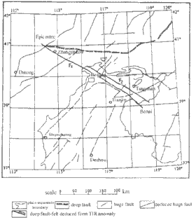 Figure 1: Geological structure and deduced buried active structuree |
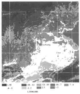 MAP OF BRIGHTNESS TEMP. CHANNEL NO.4 BEIJING AREA NOAA 14 DS 4:53 12/28/97 IRSA Figure 2: Local TIR Anomaly Image |
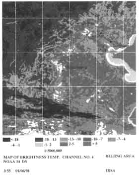 Figure 3: Strip-like TIR anomaly area |
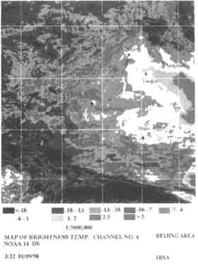 Figure 4: Bohai gulf to Zhangbei TIR anomaly zone |