Keywords: Change
detection, Yellow River delta, Remote sensing
information model.
AbstractInformation about
change is necessary for updating land cover maps
and the management of natural resources. Many
researches have been undertaken to develop
methods of obtaining change information. Based
on the summarization of the methods on change
information extracted from remotely sensed data,
the paper promotes the method of change
detection based remote sensing information
model. This method is applied to detect the
coastal line change of Yellow River Delta (YRD).
It lays the foundation for research on the
change relation of natural and human activity
impact each other, and finally aids to study the
regional geographic feature through more than 10
years remote sensing images in YRD.
1. IntroductionInformation
about change is necessary for updating land
cover maps and the management of natural
resources. The information may be obtained by
visiting sites on the ground and/ or extracting
it from remotely sensed data. For many of the
physical and cultural features on the landscape
there are optimal time periods during which
these features may best be observed. Remotely
sensed data acquired at the fixed time interval
becomes an important factor. Many researches
have been undertaken to develop methods of
obtaining change information. Change detected
from different temporal images usually reflect
natural and human activity impact each other and
then can be used to study how to form the
regional geographic feature.
As we know,
the Yellow River Delta is a delta grows fastest
in the world. Because of its new land forming
and unstable environment, its development is far
more backward than other famous large river
delta. However, the Yellow River Delta has a
good geographic location, rich natural resources
and tremendous developing potentiality. Its
development is of great importance to the
development of North China.
This paper
first summarizes the methods on change
information extracted from remotely sensed data.
Then based on the different object models the
method of change detection is mainly discussed.
Finally through more than 10 years change result
of Yellow River Delta, we analyze the coastal
line change.
2 Change Detection
Methods Based Remote Sensing Data
2.1
General Methods Temporal feature is
important and special in all the system
characteristics. Because spatial and spectral
information can be seen from images, temporal
feature is relatively abstract, it is difficult
to reflect directly. Its feature only can be
seen by the change of spatial and spectral
feature. Some commonly used change detection
algorithms are summarized and analyzed as the
following table.
Table 1 Main
algorithms of change detection
| Algorithm and
example |
Method procedure
|
Problem |
| Image Transformation
(e.g. PCA).Fung et al., 1987, 1988.(Eastman et
al., 1993, Bauer et al.,1994) |
Composition of
different temporal data, then classified or
using PCA to transform all together |
No classified change
information |
| Image Arithmetic
Change Detection.Price et al., 1992. |
Arithmetic operation
among different bands, e.g.
Dijk=Bvijk(1)-Bvijk(2)+C |
No classified change
information |
| Post-Classification
Comparison (Rutchey et al., 1994) |
Classification of
remote sensing images, then comparison pixel by
pixel |
Relay on
classification accuracy and multiple
classification |
| Data sources aided
change detection(Lunetta et al.,
1991. |
Map data or GIS aid
to analyze |
Relay on quality of
aided information |
| Spectral vector
change (Michalek et al., 1993, Johnson et al.,
1998) |
Comparison with
spectral vector of different temporal
CMpixel=
[Bvijk(2)-Bvijk(1)]2 |
Suitable for region
of spectral change
greatly |
2.2
Based on Remote Sensing Information Model Change
Detection Remote sensing information is
a complicated information. It is the
comprehensive behavior from a certain
environment. The behaviors of images varied
largely with different ground features due to
their different radiation and scattering
characters to visual light, infrared and
microwave. As a result, we can not build their
remote sensing information models for ground
feature under a unified mode. Three levels of
model are conducted to describe the ground
feature as follows:
- Spectrum vector based remote sensing
information model for ground feature:
Some
features, such as water body, vegetation, scene
of forest fire, possess distinctive spectrum
characteristic of multiple bands. Remote sensing
information is often corresponding to ground
object. This model is the starting point for a
study. It is called primitive class model.
- Multi-source information based remote
sensing information model for ground feature:
Most of ground features can not rely on just
a single information model. Especially when
coming across the appearance of different
objects but equally spectra or equally spectra
but different objects, it is necessary to use
multi-temporal remote sensing information or
other supplementary data (supported with GIS
data base) to build its corresponding remote
sensing information model for ground features.
Based on primitive class model, this model is
created by fresh supplying new element terms
according to derivate mechanism.
- Geo-knowledge based remote sensing
information model for ground feature:
Some
ground features or appearances, especially the
recessive information, can be recognized only
through complicated processing and deeply
analyzing. This kind of remote sensing
information model for ground features not only
includes spectrum vector characteristics of
ground features but also needs to add
geo-knowledge and expert knowledge and
experience as well as the process of operating
the knowledge and experience. For the reason,
the study to this model deals with wide range of
fields and is very complicated.
For
main objects such as water, vegetation and
non-vegetable, they can be extracted only by
establishment of spectral feature model. For
example,
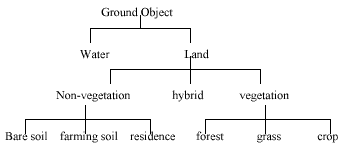
Figure 1
Hierarchy of ground objects
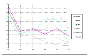
Figure 2 Spectral curve
of different objects
