| GISdevelopment.net ---> AARS ---> ACRS 1999 ---> Poster Session 5 |
Detecting Burnt Tropical
Forest using Optical and Microwave Remotely Sensed Data in South Sumatra,
Indonesia.
Heri Sunuprapto and Yousif
Ali Hussin
The International Institute for Aerospace Survey and Earth Science (ITC) 7500 AA,
Enschede, The Netherlands
Fax (31)53-4874-399
E-mail:HUSSIN@ITC.NL
The International Institute for Aerospace Survey and Earth Science (ITC) 7500 AA,
Enschede, The Netherlands
Fax (31)53-4874-399
E-mail:HUSSIN@ITC.NL
Keywords: Detection, Burnt forest, Landsat, ERS-2 radar image
Abstract:
Forest fire in Indonesia is a yearly potential caused for forest degradation. Insufficient information available about the main factors that promote the forest fire and information about the forest condition after the forest fire. This is one of the reasons why forest area neglected after they are burned. Remote sensing and GIS are helpful tools to provide a quick and accurate data acquisition and that can describe the forest condition after the forest fire. The objectives of this research were to asses the ability of optical and radar satellite remotely sensed data to detect, identify and classify forest damage (burnt area) caused by fire and to develop a spatial model for forest fire hazard.
2. Introduction
Forest is one of the most important renewable natural resources and has significant role in the human life and environment. Forest not only produce wood, both commercial timber and fuel wood, but they also protect wildlife and give them suitable environment, maintain the watershed balance and groundwater content, protect the soil fertility, and absorb carbon and another pollutant gasses from the atmosphere. All of these forest functions influence to the continuity of life and has a global aspect.
Due to natural causes and human activity forest has been degrading, both forest area degradation and forest condition and quality. Forest area decreased in huge number annually. Forest quality degrade on its productivity, degrade in biodiversity, degrade on its capability to fulfil the forest function. One of the main cause that responsible to forest degradation is forest fire.
Roughly 175 million acres of forest and grassland are burned each year world-wide. Due to large-scale human deforestation activities, grassland fires, and naturally occurring wild fires around the world, biomass burning is a major source of greenhouse gases and aerosols (tiny liquid or solid particles suspended in the atmosphere). These “emission products” significantly impact atmospheric chemistry, clouds, and the Earth’s radiant energy budget (heat and sunlight) in ways that influence climate on regional and global scales. In recent months, the extensive fires in Florida, Mexico, Brazil, and Indonesia have catapulted this topic into the news headlines.
In Russia. The temporal series (fire season between 1947 and 1992) of the area affected forest fire on the Forest Fund’s actively protected territory is characterised by great variability in both the number of fires and the annual area burned. The number of fires ranged from 10,000 to 34,000 annually, with the corresponding area burned varying between 200,000 and 2,700,000 hectares (Goldammer and Furyaev, 1996).
In the last two decades, fire has become one of the greatest threats to tropical rainforest, especially in Indonesia. Fire has been a recurring feature of the islands of Borneo and Sumatra, burning large areas in 1986, 1991, 1994 and 1997. Boosted by 1997/1998 El Nino phenomenon uncontrolled fires have destroyed huge areas of rain forest and bushland in Indonesia. Since the 1986 fires, Indonesia has been at odds with neighbouring Malaysia and Singapore, as the haze from these fires covered the South East Asian region for weeks, causing health problems, disruption of shipping and aviation, and culminating in the closure of international airports. Economic losses and ecological damage were enormous.
The recent fire disaster in Indonesia shows the need for a forest fire monitoring and damaged assessment. The activities should be done in order to provide a reliable and up to date information about the recent forest cover area and its quality to support forest management purposes.
In considering the applications of remote sensing, foresters and geologist have been the main operational users of the collected data for many years. Sometimes the remote sensing system provides unique data that cannot be obtained by any others source; but much more often that collected data facilitates field work and enables task to be completed at lower cost and much more quickly. It is unlikely, these days, that forest inventory would be undertaken without remotely sensed data. Usually field collected data provides more accurate and precise result, but the collection of the data is slow. In rugged terrain, it may be economically impracticable or confined only to a few ground samples in accessible locations. Ensuing from this the common forest practise of marrying remotely sensed data and field data and cross-checking continuously the result of image analysis and field samples.
Due to the difficulty of monitoring burned forest areas and the absence of detailed fire records in many areas the possibility of using remote sensing satellite observations will be examined. Since the inaccessible of large forest areas should be monitored employing remote sensing data and techniques become more necessary.
Some remote sensing techniques and data can be used for the detection of forest fire and the assessment of their affects. The application of the forms of the remote sensing depends on the character of forest management. The multi-spectral scanner data from the aerial and satellite platform can be used in the extensive management of great areas. Attention has been drawn to the fact that the detection of damaged caused by fires may concern large areas only .
In recent time radar system has a significant role in remote sensing since there are some limitation with optical remote sensing system like cloud cover penetration capability. Radar data which utilizes the microwave portion of the spectrum can provide important additional information of terrain surface and vegetation canopies (Stellingwerf and Hussin, 1997).
The objectives of this research were to asses the ability of optical and radar satellite remotely sensed data to detect, identify and classify forest damage (burnt area) caused by fire and to develop a spatial model for forest fire hazard.
3. Methods
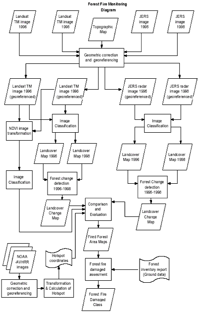
In order to investigate the effect of forest fire and to asses the ability of remote sensing data to detect, differentiate and classify forest damaged caused by fire, remotely sensed data and image processing techniques were employed. Data and basic methodology can be seen in Figure 1.
4. Results and Discussions
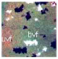
Several operations of image pre-processing and processing are still under way to analyse the data of this research. However, preliminary results of the visual interpretation are presented in this paper. Figure 2 (a) and (b), (c) and (d) show Landsat TM image (bands combination 453 in RGB) of two areas of 3x3 Km from the test site. The images show the forest before and after the fire 1996-1998. The visual interpretation of the multi-temporal optical and radar satellite data resulted in follow classes recognition:
- Landsat TM image of November 1996, bands combination 453
- Logged over forest
- Young secondary forest
- Virgin forest (dense primary forest)
- Transmigration area (home stead garden)
- Grass land
- Landsat TM image of June 1998, bands combination 453
- Burnt logged over forest (distinct)
- Burnt young secondary forest (not distinct)
- Unburned logged over forest (distinct)
- Burnt virgin forest (distinct)
- Burnt home stead garden (distinct)
- Unburned grass land (not distinct)
- The 1996 ERS-2 radar image
- Logged over forest
- Young re-growth (young secondary forest)
- Virgin forest (dense primary forest)
- Transmigration area (home stead garden)
- Bare land
- Grass land
- The 1998 ERS-2 radar image
- Burned area of logged over forest
- Burned area of young secondary forest
- Unburned logged over forest
- Burnt virgin forest
- Burnt home stead garden (transmigration area)
- Unburned area of grass land
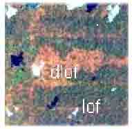 (a) |
Landsat TM 453 in RGB Nov 1996 Lof = logged over forest Dlof= degraded logged over forest |
 (b) |
Landsat TM 453 in RGB Jun 1998 Grs = grass Blof = burnt lo gged over forest |
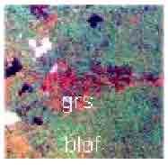
 (c) |
Landsat TM 453 in RGB Nov 1996 Vf = virgin forest |
 (d) |
Landsat TM 453 in RGB Jun 1998 Bvf = burnt virgin forest Uvf = unburnt virgin forest |
References
- Stellingwerf D.A. and Yousif A. Hussin. 1997. Measurement and Estimation of Forest Stand Parameters Using Remote Sensing. Utrecht, The Netherlands : VSP. 272 pp.
- Goldammer J. G. and Valentin V. Furyaev. 1996. Fire in Ecosystem of Boreal Eurasia. Dordrecht/Boston/London : Kluwer Academic Publishers. Pages : 1-20 and 139-149