| GISdevelopment.net ---> AARS ---> ACRS 1999 ---> Poster Session 5 |
Land Cover Change and its
Effect on Runoff in the Doki River Catchment
Ikuyo Makino* (Japan)
* Rotech Co. Ltd.
1403-1 Yahata, Chigasaki, Kanagawa 253-0085 JAPAN
Phone & Fax: +81-467-85-5961
Email: ikuyo@ff.iij4u.or.jp
Susumu Ogawa**, Genya Saito**
**National Institute of Agro-Environmental Sciences
3-1-1 Kannondai, Tsukuba, Ibaraki 305-8604 JAPAN
Phone: +81-298-38-8192; Fax: +81-298-38-8199
E-mail:http://www.gisdevelopment.net/aars/acrs/1999/ps5/remote@niaes.affrc.go.jp
Keywords: agricultural fields, deforestation, evapotranspiration, Landsat TM, runoff ratio
Abstract
Land cover change and discharge fluctuation for the past 12 years in the Doki River catchment were examined using multi-temporal satellite data. This catchment is composed of mainly forest and some agricultural fields along the streams, the ratio of which is more than 10 % of the total area. Using the multi-temporal satellite data, Landsat TM, in 1986 and 1990, approximately 3 % of the total area had changed from forest to the agricultural fields during this period. From the water budget from 1981 to 1992 in the catchment, evapotranspiration decreased and runoff ratio increased. Short-term water budget led to monthly evapotranspiration before and after 1986, which showed the evapotranspiration in April and October decreased. Such change means agricultural activities, seeding and harvest. Moreover, statistical tests for hydrological data before and after 1986 showed that runoff ratio increased significantly with 0.05 of significant level. Therefore, one of the factors that caused the increase of runoff ratio in the catchment should be the land cover change from forest to agricultural fields.
1. Introduction
Land cover changes in the basin affect on its discharge and bring not only flood but also hard conditions to get agricultural and urban water supply. Especially, land use changes to agricultural fields or golf courses by deforestation have been paid attention as an important environmental change in the same way as urbanization recently (e.g. Jordan & Heuveldop, 1981). Then, land cover change and its effect on long-term water budget in the Doki river basin in the western part of Japan were examined from its satellite data and hydrological data. The effect of small development for land cover was evaluated with the long-term trends of water budget and the seasonal profiles of monthly evapotranspiration.
2. Materials and Methods
An objective site is located in the Doki river basin in Shikoku Island, Japan. The satellite data of multi-temporal Landsat TM (Table 1) were used for calculation of land cover classification, its area ratios, and NDVI.
DEM, 25,000 and 50-m mesh, was used for the watershed separation. Hydrological data were precipitation and discharge in the Doki river observed for 12 years by Ministry of Construction. Discharge observation sites are located at Goyo Bridge (Drainage area: 72.1 km2 ) and Tsunekane Bridge (90.0 km2 ), while precipitation observation site is located at Miai at upper stream of the Doki river watershed as shown in Fig. 1. Meteorological data were used for evapotranspiration. The meteorological observation sites are at Tadotsu Meteorological Observation Station and Shikoku National Agricultural Experiment Station in Ministry of Agricultural, Forest and Fishery.
Basin boundaries were determined semi-automatically by TNTmips, GIS software, from DEM with 50-m mesh. The boundary that intersects the discharge observation site was determined with geomorphologic maps considering micro drainage areas. Annual evapotranspiration was calculated from annual precipitation and discharge for 12 years in the Doki river basin using Equation (1). Water balance was calculated from monthly rainfall and discharge using the next equation to get evapotranspiration. Also runoff ratio was obtained from r=Q/P.
where S is the storage, P the rainfall, Q the discharge, and E the evapotranspiration. Moreover, monthly evapotranspiration was also calculated with short-term water budget method.
Daily evapotranspiration each land cover was derived from meteorological data using the Penman equation (Brutsaert, 1982).
where D=(de*/dT)T, lº CpP/el, Qn is the available energy flux density in mm/day, f(u) the wind function in mm/day, u the mean wind speed in m/sec, ea* the saturation vapor pressure in hPa, ea the vapor pressure in hPa, Rn the net radiation in W/m2 , Ll the latent heat of vaporization (=2.454.106 J/kg), Rs the short-wave radiation in W/m2, as the albedo of the surface, Rld the downward long-wave radiation in W/m2 , Rlu the upward long-wave radiation in W/m2 , es the emissivity of the surface (=0.97), ea the atmospheric emissivity, a the Stefan-Boltzmann constant (=5.67*10-8Wm-2K-4), Ta the air temperature in K, and Ts is the surface temperature in K.Here, albedo each land cover was referred from empirical values (Kotoda, 1986).
Land cover classification was carried out from Landsat TM with the maximum likelihood method to obtain 7 land covers: forest, paddy fields, vegetable fields, bare soils, urban areas and water body, and their area ratios. The ground truth was confirmed for land use in June 1998 and February and June 1999.
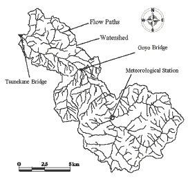
Fig. 1 Doki River and its observation stations
Table 1. Satellite data used. From 1986 till 1990,
agricultural development was carried out.
| Satellite | Date |
| LandsatTM | 1986/4/12, 9/3, 11/6.1990/3/22, 5/9 |
3. Results and Discussion
Land cover area ratios are shown in Table 2 from the land cover classification of the Doki river basin in 1986 and 1990. Comparing 1990 with 1986, about 3 % of forest area decreased instead agricultural fields increased by the same ratio. Here, considering land use, agricultural fields change as paddy fields, vegetable fields, bare soils, and grass seasonally, and therefore these categories should be unified to one land cover. Land cover classification maps in 1986 and 1990 are shown in Fig. 2, where conventionally forest, agricultural fields and others are indicated. In total, a part of forest in 1986 was changed to agricultural fields by 1990. This part equals about 3 % of the total basin.
| Year | Forest | Paddy Field | Vegetable Field | Bare Soils | Grass | Urban Area | Water |
| 1986 | 88.4 | 6.1 | 4.2 | 0.0 | 0.0 | 0.7 | 0.6 |
| 1990 | 85.5 | 5.6 | 6.2 | 1.1 | 0.2 | 0.9 | 0.5 |
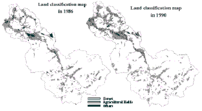
Fig. 2 Land cover classification in the Doki river
basin using Landsat TM in 1986 and 1990.
Long-term water budget change
The results of water balance from 1981 till 1992 are shown in Table 3. From annual precipitation and discharge from 1981 till 1992, annual evapotranspiration and runoff ratio were calculated. During this period including 1986, annual precipitation indeed increased, but annual discharge increased more than the increase rate of precipitation as shown in Fig. 3. On the other hand, annual evapotranspiration increased at the Goyo Bridge, but decreased at the Tsunekane Bridge. Annual runoff ratio increased with 0.05 of significant level. As shown in Fig.4, annual runoff ratio was the minimum in 1985, and had peaks in 1990 and 1993. The latter peak seems to be affected by golf course development (Makino et al., 1999). In total, annual runoff ratio increased monotonously from 1985 till 1990. Moreover, including the total observation period from 1970 till 1995, annual runoff ratio increased. Since annual precipitation shows almost constant, the increase of runoff ratio may be affected by the independent factor from meteorological factors.
and runoff ratio in the Doki river basin (Unit: mm).
| Period | Rainfall | DischargeG | DischargeT | EvaporationG | EvaporationT | Runoff RatioG | Runoff RatioT |
| 1981-86 | 1122±67 | 377±70 | 422±53 | 745±39 | 701±47 | 0.33±0.05 | 0.37±0.04 |
| 1987-92 | 1412±116 | 632±121 | 778±135 | 780±51 | 634±37 | 0.43±0.05 | 0.53±0.05 |
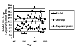
Fig.3 Time series of rainfall, discharge and evapotranspiration
in the Doki river basin (1986-1995).
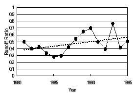
Fig. 4 Runoff ratio in the Doki river basin(1986 -1995).
Runoff ratio increased during the observation.
Various evapotranspiration estimates
Evapotranspiration is estimated by water budget method, direct observation with a pan evaporator, and the modified Penman method from meteorological data. A pan evaporator indicates evaporation from water body and means potential evaporation, the maximum evaporation, and independent values from land use depending on meteorological conditions. The Penman method overestimates evapotranspiration each land cover. These three methods were compared on average separating the data in 1986 shown in Table 4. All the values decreased commonly beyond 1986. The rates of their decrease were almost equal, ranging 85 to 90 %. Therefore, the change of evapotranspiration was brought by meteorological factors; the contribution of land cover should be small.
pan evaporation and Penman’s method. (Unit: mm)
| Period | Water Balance | Pan Evaporation | Penman’s Method |
| 1981-1986 | 701.47 | 1208.63 | 902.24 |
| 1987-1992 | 634.37 | 1029.50 | 784.25 |
Short-term water budget
The results of short-term water budget were shown in Fig.5. Monthly evapotranspiration changed a bit before and after 1986; in April and October evapotranspiration decreased on average. During these period agricultural fields become bare soils for seeding and harvesting. Thus, evapotranspiration decreases for them. Therefore, the decrease of evapotranspiration in April and October was contributed by agricultural activities. That corresponds to the land cover change from forest to agricultural fields. Moreover, the decrease of evapotranspiration seemed to correspond to withering paddy and grass.

Fig. 14 Monthly change of evapotranspiration
in the Doki river basin
4. Conclusions
From the satellite data in 1986 and 1990, 3 % of forest area was replaced to agricultural fields. For 12 years including 1986, significant increase of runoff ratio was examined with 0.05 of significant level. As the result of short-term water balance, for the past 12 years monthly evapotranspiration decreased in April and October for agricultural activities. The increase of runoff ratio in the Doki river should be derived from the change of land use from forest to agricultural fields.
Acknowledgement
We appreciate NASDA, Japan for providing Landsat TM data. A part of this study was collaborated with NASDA, Japan as a project study named “Agriculture Monitoring Using Satellite Remote Sensing”. This study was carried out under a cooperative system for supporting priority research, which was implemented by Japan Science and Technology Corporation.
References
- Jordan, C.F. & Heuveldop, The water budget of an Amazonian rainforest, Acta Amazonica, 11, 87-92, 1981.
- Ministry of Construction, River Bureau, Annual Rainfall Report, Japan River Association, 1981-1995.
- Ministry of Construction, River Bureau, Annual Discharge Report, Japan River Association, 1981-1995.
- Meteorological Agency, Monthly Meteorological Report, 1981-1992.
- Ministry of Agriculture, Forestry and Fisheries, Shikoku National Agricultural Experiment Station, Research Materials, No.1,1988, and No.9, 1992..
- Suzuki, M., Evapotranspiration estimates from forest basin using short-term water budget method, Journal of Japan Forest Society, 67,4,115-125,1985.
- Brutsaert, W.H., Evaporation into the Atmosphere, Kluwer Academic Pub., Boston, 1982.
- Kotoda, K, Estimation of River Basin Evapotranspiration, Environmental Research Center, University of Tsukuba, 1986.
- Makino, I., S. Ogawa, G. Saito, Land cover change and discharge fluctuation in the Doki river, Environmental Engineering Forum, in print, 1999.