| GISdevelopment.net ---> AARS ---> ACRS 1999 ---> Poster Session 4 |
Chinese Cryospheric
Information System
Li Xin, Cheng Guodong, Wu Qingbai and Ding
Yongjian
Lanzhou Institute of Glaciology and Geocryology
Chinese Academy of Sciences, Lanzhou 730000, P. R. China
Lanzhou Institute of Glaciology and Geocryology
Chinese Academy of Sciences, Lanzhou 730000, P. R. China
Abstract
The Chinese Cryospheric Information System (CCIS) is an integrated Geographic Information System for storing, managing and analyzing the cryospheric data within China. Three regions are selected as the case study areas of CCIS with different scale. They are the Qinghai-Tibet Plateau with a scale of 1:4,000,000, the regions along the Qinghai-Tibet Highway with a scale of 1:250,000 and the Urumqi River Basin with a scale of 1:50,000.
As an information infrastructure of the cryosphere science, a draft classification and geo-coding system that can express the logical hierarchy of cryospheric data had been established fundamentally. Based on this, CCIS had stored a big amount of data including maps of glacier, frozen ground and other environmental elements, digital elevation data, observation data of meteorological stations, hydrological gauges and permafrost boreholes and remote sensing data. CCIS is managed by ARC/INFO and can export data to other GIS environment easily since data exchange interfaces are paid particularly attentions in CCIS.
Based on CCIS, several GIS-based models about cryospheric processes and cryospheric response to global change had been developed. We introduce three models in this paper. They are a response model of high altitude permafrost to global change, an evaluation model of engineering properties in permafrost regions along the Qinghai-Tibet Highway, and a model of glacier mass balance estimation.
1 Introduction
Cryosphere is defined as the freezing part of atmosphere, hydrosphere, biosphere and lithosphere. This includes ice sheets, ice shelves, ice caps and glaciers, sea ice, seasonal snow cover, lake and river ice, and seasonally frozen ground and permafrost. The importance of the cryosphere in the global climate system is related to the significant seasonal change of snow and ice cover, inducing the amount of energy absorbed at the surface dramatically. The global change study had shown that cryosphere is very sensitive to global change so that the change of cryosphere is consider as a pointer of global change. Global warming will make a significant shrinkage in cryosphere extend and volume, therefore impacting greatly on human living. Global warming will also cause a positive feedback between snow and ice albedo and air temperature, and change permafrost area from carbon sink to carbon source. These processes will have great feedback on climate system (IPCC, 1990; IPCC, 1992; Fitzharris et al., 1995; Cheng, 1996; Nelson et al., 1993).
China has vast expanse of cryosphere and contains a large part of the world’s middle and low-latitude mountain glaciers. China’s permafrost area ranks third in the world, of which the middle and high-altitude permafrost area ranks first in the world. And particularly, the Qinghai-Tibet Plateau plays very important role in global change. Therefore, the Lanzhou Institute of Glaciology and Geocryology, Chinese Academy of Sciences (LIGG) had made efforts to set up a GIS of Chinese cryosphere (Li et al, 1997; Li, 1998), namely the Chinese Cryosphere Information System (CCIS). The objectives of CCIS are as follows:
2.1 General Structure and Case Study Areas
CCIS is a comprehensive information system used to manage and analysis the cryospheric data of China. The establishment of the system, in one hand, can meet the demand of the earth system science to provide parameters and validation data for development of GIS-based response and feedback models of frozen soil, glacier and snow cover to global change; on the other hand, can provide a scientific, effective and safe management and analytical tool used to systematically collect and rescue valuable cryospheric data.
The general structure of CCIS is shown in Figure 1.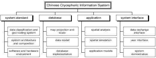
Figure 1. General structure of the Chinese Cryospheric Information System
2.2 System Standards
2.2.1 Geo-Coding System of Cryospheric Data
The classification of cryospheric data should be able to reflect their characteristics, types and interrelationship. CCIS includes three major types of data, namely cryospheric data, natural environmental data and socioeconomic resource data. Based on the classification of cryospheric data, a draft geo-coding system that can express the logical hierarchy of cryospheric data had been established fundamentally. The geo-coding principles of CCIS are as follows: it must consistent with the classification of the cryosphere science and can clearly reflect the logical structure of GIS. In addition, it should be compatible with existing international and national standards. The geo-coding schema of CCIS is in the form: Region Code + Source Code + Level Code + Supplement Code. There are nine codes, first is region code, indicating the three case study areas of CCIS; second is source code, indicating the data source; third – sixth are level codes, referring to the high-level classification of cryospheric data; seventh to ninth are supplement codes, referring to the low-level classification of cryospheric data.
2.2.2 System Composition
CCIS is composed of four sub-systems, namely data source, data pre-processing sub-system, data analysis sub-system, and system users.
Data source
It includes many kinds of thematic maps, topographic maps, observation data such as climatic, borehole and hydrological data, and section planar drawings of permafrost-engineering within the three case study areas.
Data pre-processing sub-system
CCIS receives various sources of data, complies and purifies them automatically or in the man-machine interaction way. Then, the processed data are given unique geo-codes and stored in CCIS.
Data analysis sub-system
Some spatial analysis methods have been developed in CCIS, including grid analysis, irregular triangular network analysis, topographic analysis, spatial interpolation, spatial resampling and overlay etc. We pay particularly attention on developing some spatial interpolation methods by combining geo-statistics and physical processes, because there are so few meteorological stations in cryospheric regions.
System user
CCIS is an important tool used to analyze and study cryospheric phenomena by scientists. It is also a tool used for planning the sustainable development of the cryosphere region by decision-makers and planners.
2.2.3 Software and Hardware Environment
CCIS is based on client/sever architecture. Data process and global database management is based on a SPARC workstation, the software is ARC/INFO 7.0 for UNIX. Local GIS database is managed by PC ARC/INFO and ArcView 3.0a. PC ARC/INFO and IDRISI are also used to process not-very-complex GIS analysis and to develop application models. CCIS can export data to other GIS environment easily since data exchange interfaces are paid particularly attentions.
2.2.4 Map Projection and Data Scale
The equal-area conical projection is adopted in the Qinghai-Tibet Plateau, while the transverse Mercator projection is adopted in the Qinghai-Tibet Highway and the Urumqi River Basin. The scale of the Qinghai-Tibet Plateau is 1:4,000,000, grid resolution is 5000*5000m. The scale of the Qinghai-Tibet Highway is 1:250,000, grid resolution is 100*100m. The scale of the upper reaches of Urumqi River is 1:50,000, grid resolution is 5*5m--100*100m.
3 Modeling Cryospheric Response to Global Change
3.1 A GIS Aided Response Model of High Altitude Permafrost to Global Change
3.1.1 Data and Climatic Scenarios
The original Digital Elevation Model (DEM) of the Qinghai-Tibet Plateau has a high spatial resolution. It was resampled to a coarse resolution of 0.5 degree. The permafrost map complied by Li Shude and Cheng Guodong (1996) was digitized to provide the base data, because it reflects the most up-to-date permafrost observations. The map was transferred to a grid map with a resolution of 0.5° by ARC/INFO, so that it could be spatially registered with the DEM.
The GCM model HADCM2 (Viner, 1996), which was developed at the Hakley Center for Climate Prediction and Research in Britain, was adopted for climate senarios. We only use air temperature scenarios in permafrost response model. In order to preserve the original air temperature forcast results in the HADCM2, the nearest- neighbor method was used to resample the air temperature for the years 2009, 2049 and 2099 into 0.5°*0.5° grids compatible with the DEM. The maps of air temperature change show that, for the above three times, the air temperature would increase by 0.51, 1.10 and 2.91°C, C, respectively, on the Qinghai-Tibet Plateau. The maximum air temperature increases would be 1.62, 2.99 and 5.45°C respectively.
3.1.2 The Altitude Model
We used the altitude model to simulate permafrost distrubution on the Qinghai-Tibet Plateau. Altitude model is based on the three-dimensional zonation in the distribution of high altitude permafrost, namely, vertical, latitudinal and aridity (or longitudinal) zonation (Cheng, 1984; Cheng and Dramis, 1992). By using the method of curve fitting, the empirical corretation between lower limit of high altitude permafrost (H) and latitude (i) has been obtained. It can be expressed as:
H=3650exp[-0.003(i-25.37)2]+1428 (1)
Because the altitude model takes the lower limit as the main criterion of high altitude permafrost distribution, DEM can be used to calculate the lower limit of every grid and compare it with the altitude of the same grid to conclude if there has permafrost on the grid. The judgment function can be expressed as:
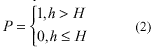
where, P is a Boolean variable, P=1, means there exists permafrost, P=0, means there does not exist permafrost; h is the altitude (m) of the grid.
The simulation result shows that the altitude model can describe the permafrost distribution on the Qinghai-Tibet Plateau very well. If the 1800 spatial sample in the mapping area are taken for regression analysis, the correlation is 0.92 and the coefficient of determinacy is larger than 85%. Meanwhile, the permafrost area in simulation result is 1,294,376 km2, comparing it with the actual area 1,272,709 km2 (after vector to raster processing), the error is only 1.70%.
3.1.3 Permafrost Change on the Qinghai-Tibet Plateau
There are no climate variables in the altitude model, therefore, some assumptions must be given out to forecast the permafrost response to global change. These assumptions are: 1) The function that describes high altitude permafrost distribution will not change according to the climate warming. 2) If air temperature increases 1°C, the vertical zonation will rise a certain height agreeing on the lapse rate, the lower limit of the high-altitude permafrost will rise the same height. 3) Lakes, glaciers, deserts will not change.
Based on the above assumptions, and if only air temperature increase is taken into account, the permafrost distribution in the year of 2009, 2049 and 2099 can be forecasted by using the altitude model.
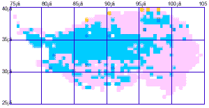
The results show that the permafrost on the Plateau will not change significantly during 20-50 years, the percentage of the total disappeared area will not over 19%. However, by the year of 2099, if the air temperature increases by an average of 2.91°C on the Plateau, the decrease in the area of permafrost will exceed 58%, almost all the permafrost in the Southern Plateau and in the Eastern Plateau will disappear (Figure 2).
Present permafrost
distribution
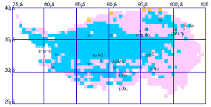
Permafrost change when air temperature rise 0.51°C
Permafrost change when air tem[erature rises 1.10°C
Permafrost change when air temperature rises 2.91°C
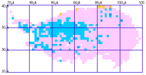
Figure 2. The altitude model simulation result of permafrost change on the Qinghai-Tibet Plateau
3.2 A GIS Aided Evaluation Model of Engineering Properties in Permafrost Regions along the Qinghai-Tibet Highway
3.2.1 GIS of the Qinghai-Tibet Highway
The impacts of global warming on the Qinghai-Tibet Highway are obvious (Tong and Wu, 1996; Zhu et al., 1996). In the case study along the Qinghai-Tibet Highway, we paid particularly attention to the evaluation of permafrost-engineering properties because frozen soil environment was heavily destroyed when the Highway was constructed. The GIS of the Qinghai-Tibet Highway covers the part of the highway from Xidatan to Naqu, which is about 700km long and 20-30km wide. It stores information about digital elevation data, borehole data, ground temperature, the Quaternary geology, and other permafrost data. The scale of the topographic and thematic maps is 1:250,000 and the grid resolution of DTMs (digital terrain model) is 100*100 m. Based on the GIS, two models are developed. They are the permafrost distribution model and the ground temperature zonation model, the two models evaluate permafrost-engineering properties in different stability zones.
3.2.2 Modeling the Permafrost stability
Traditional one-dimensional climate-permafrost model cannot be applied for regional permafrost mapping along the Qinghai-Tibet Highway because of great regional difference in surface characteristics. Modeling permafrost-engineering properties along the Qinghai-Tibet Highway must consider high-altitude permafrost characteristics, permafrost vertical zonation, and mean annual ground temperature (MAGT),. We firstly use the altitude model to estimate the lower limit of permafrost along the Qinghai-Tibet Highway. And then, we use the following equation to calculate the MAGT on each grid. The equation was based on a relationship among MAGT, the altitude and the latitude. It is obtained using ground temperature measurements along the Qinghai-Tibet Highway (Cheng and Wang, 1982).
T=68.873-0.00827H-0.923L (3)
where T is MAGT; H is the altitude (m); L is the latitude. And for 40 data samples, the regression coefficient is 0.96.
The permafrost stability has been divided into five types according to the MAGT (Cheng and Wang, 1982). By using equation 3 and DTMs, the stability type of each grid along the Qinghai-Tibet Highway is computed. Then, the map of permafrost stability zones is obtained according to the MAGT of each grid and permafrost classification. The upper zone of permafrost generally exists in high mountain areas, middle zone exists in Chumaer river high plain areas, mountain base areas and river valley areas, and the lower zone do not exist alone the Qinghai-Tibet Highway. This result verified the effectiveness of the model.
3.2.3 Change of Permafrost-Engineering Properties along the Qinghai-Tibet Highway
The permafrost change due to global warming will induce significant damages in the structure of engineering construction along the Qinghai-Tibet Highway through the increasing frost heaving and thaw settlement (Tong and Wu, 1996). Therefore, predicting the permafrost change along the highway at a reasonable precision is urgent for the mitigation and rehabilitation of engineering hazards and protection of cold region environment. To predict the change of permafrost stability, we set up a relationship between MAGT and mean annual air temperature (MAAT) (Tong and Wu, 1996):
Tz=
0.414exp(0.326ta)-1 (4)
Where Tz is MAGT(°C); ta is MAAT( °C).
And assuming that rising air temperature would result directly in immediate permafrost warming. The rising MAAT at lower limit will result in the changing MAGT of permafrost zone. The response model of permafrost stability zone is proposed:
Tz=68.873+DTz-0.00827H-0.923L (5)
Where Tz is the MAGT after MAAT rising; DTz is the ground temperature increase at lower limit after climate change and its value is calculated by output results of HADCM2.
The results show that permafrost stability will change greatly under climate warming. Their area extent is expected to decrease and permafrost zone will be moving upward and degrading. In order to easily discuss permafrost zone change, the relative changes of permafrost zone in a 30km buffer area along the Qinghai-Tibet Highway are considered (figure 3). The areas of extreme stable zone, stable zone and sub-stable zone will decrease, while the areas of transit zone, unstable zone and extreme unstable zone will increase. The actual areas changed are shown in figure 3.
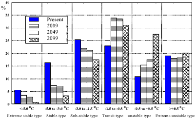
Figure 3. The change of permafrost stability along the Qinghai-Tibet Highway
3.3 A Distributed Calculation Method for Glacier Volume Change
3.3.1 Calculation Method
Five topographic maps of glacier No. 1 in the headwaters of the Urumqi River Basin in different time, namely 1962, 1964, 1973, 1980 and 1986, were digitized. Then, ARC/INFO was used to make DEMs of the glacier. The resolution of all the DEMs is 5 meter.
Traditionally, pole method was widely used for estimation of glacier mass balance , which estimates mass balance for a whole glacier from a few typical and discrete records. Therefore, the calculated result depends on the sampling numbers, their accuracy and representative. We developed a distributed method for estimating glacier volume change based on DEM calculation. With high resolution DEMs in different periods, the glacier volume change can be obtained on the grid level and thus the mass balance of whole glacier can be estimated. The distributed method can be expressed as:
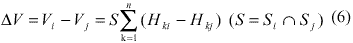
Where, DV is the volume change; S is the intersection of glacier areas in time i and time j; Hki and Hkj are DEM values in time i and time j.
Compared with traditional pole method, the distributed method is quick, visualized and economic, and can be used by the altitude measurements from remote sensing and GPS directly.
3.3.2 Glacier Volume Change
Table 1. Change of the Glacier No. 1 at the headwaters
of
the Urumqi River computed by the distributed method
Table 1 shows the result of glacier change by using the distributed method. To verify the method, the computation result is compared with measured mass balance. In the compared duration from 1980 to 1986, the height of glacier surface and ice volume computed by the visualized method decreased about 1653mm and 2.87*106m3 and those by traditional method decreased 1961mm and 3.61*106m3. If measured specific mass balance is corrected based on glacier area change, then the height of glacier surface and ice volume computed by traditional method decreases 1849mm and 3.308106m3 . It is also found that there is a close relationship between the distributed method and pole method. The causes of the errors have been analyzed. Most of the errors come from measurement and calculation of mass balance. Partial error is caused by the accuracy of DEMs.
4 Research Priorities
Our next research will focus on the remote sensing of snow and frozen soil using SSM/I data. The objective is to get a long time series of snow cover and freeze/thaw cycle data sets. The NASA’s SSM/I snow depth algorithm is obviously overestimated in the Qinghai-Tibet Plateau. The main reason of overestimation is the influence of permafrost because it has similar scattering property with snow, therefore, we are trying to validate the SSM/I algorithms and set up some new relationship by using spatial statistics. However, our preliminary research gets no good results, but does demonstrate the complexity of snow depth estimation by SSM/I in the Qinghai-Tibet Plateau (Li et al., 1999). It can be concluded that the elimination of the influence of frozen soil must be taken as the first step of snow depth estimation. This can be applied by data fusion of visible images such as NOAA AVHRR and SSM/I data.
Reference
The Chinese Cryospheric Information System (CCIS) is an integrated Geographic Information System for storing, managing and analyzing the cryospheric data within China. Three regions are selected as the case study areas of CCIS with different scale. They are the Qinghai-Tibet Plateau with a scale of 1:4,000,000, the regions along the Qinghai-Tibet Highway with a scale of 1:250,000 and the Urumqi River Basin with a scale of 1:50,000.
As an information infrastructure of the cryosphere science, a draft classification and geo-coding system that can express the logical hierarchy of cryospheric data had been established fundamentally. Based on this, CCIS had stored a big amount of data including maps of glacier, frozen ground and other environmental elements, digital elevation data, observation data of meteorological stations, hydrological gauges and permafrost boreholes and remote sensing data. CCIS is managed by ARC/INFO and can export data to other GIS environment easily since data exchange interfaces are paid particularly attentions in CCIS.
Based on CCIS, several GIS-based models about cryospheric processes and cryospheric response to global change had been developed. We introduce three models in this paper. They are a response model of high altitude permafrost to global change, an evaluation model of engineering properties in permafrost regions along the Qinghai-Tibet Highway, and a model of glacier mass balance estimation.
1 Introduction
Cryosphere is defined as the freezing part of atmosphere, hydrosphere, biosphere and lithosphere. This includes ice sheets, ice shelves, ice caps and glaciers, sea ice, seasonal snow cover, lake and river ice, and seasonally frozen ground and permafrost. The importance of the cryosphere in the global climate system is related to the significant seasonal change of snow and ice cover, inducing the amount of energy absorbed at the surface dramatically. The global change study had shown that cryosphere is very sensitive to global change so that the change of cryosphere is consider as a pointer of global change. Global warming will make a significant shrinkage in cryosphere extend and volume, therefore impacting greatly on human living. Global warming will also cause a positive feedback between snow and ice albedo and air temperature, and change permafrost area from carbon sink to carbon source. These processes will have great feedback on climate system (IPCC, 1990; IPCC, 1992; Fitzharris et al., 1995; Cheng, 1996; Nelson et al., 1993).
China has vast expanse of cryosphere and contains a large part of the world’s middle and low-latitude mountain glaciers. China’s permafrost area ranks third in the world, of which the middle and high-altitude permafrost area ranks first in the world. And particularly, the Qinghai-Tibet Plateau plays very important role in global change. Therefore, the Lanzhou Institute of Glaciology and Geocryology, Chinese Academy of Sciences (LIGG) had made efforts to set up a GIS of Chinese cryosphere (Li et al, 1997; Li, 1998), namely the Chinese Cryosphere Information System (CCIS). The objectives of CCIS are as follows:
- To make a detailed design CCIS, drafting the system standards;
- To build up a geographic information system that integrated closely with cryospheric models;
- To analysis the spatial and temporal change of Chinese cryosphere using spatial analysis;
- To develop some application models of cryosphere response to global change (Li and Cheng, 1999; Li et 1998; Wu et al., 1998; He et al, 1999).
2.1 General Structure and Case Study Areas
CCIS is a comprehensive information system used to manage and analysis the cryospheric data of China. The establishment of the system, in one hand, can meet the demand of the earth system science to provide parameters and validation data for development of GIS-based response and feedback models of frozen soil, glacier and snow cover to global change; on the other hand, can provide a scientific, effective and safe management and analytical tool used to systematically collect and rescue valuable cryospheric data.
The general structure of CCIS is shown in Figure 1.
- Three regions in different scale were selected as the main case study areas of CCIS. They are: (1) Qinghai-Tibet Plateau, 70--105°E, 25--40°N.
- Qinghai-Tibet Highway, with 20--30 km width on both sides.
- Urumqi river basin in the Tienshan Mountain, 86--89°E, 42--45°N, the key study area is located in the upper reaches of Baiyanggou between 86°45'--87°30'E and 43°00'30 N.
Figure 1. General structure of the Chinese Cryospheric Information System
2.2 System Standards
2.2.1 Geo-Coding System of Cryospheric Data
The classification of cryospheric data should be able to reflect their characteristics, types and interrelationship. CCIS includes three major types of data, namely cryospheric data, natural environmental data and socioeconomic resource data. Based on the classification of cryospheric data, a draft geo-coding system that can express the logical hierarchy of cryospheric data had been established fundamentally. The geo-coding principles of CCIS are as follows: it must consistent with the classification of the cryosphere science and can clearly reflect the logical structure of GIS. In addition, it should be compatible with existing international and national standards. The geo-coding schema of CCIS is in the form: Region Code + Source Code + Level Code + Supplement Code. There are nine codes, first is region code, indicating the three case study areas of CCIS; second is source code, indicating the data source; third – sixth are level codes, referring to the high-level classification of cryospheric data; seventh to ninth are supplement codes, referring to the low-level classification of cryospheric data.
2.2.2 System Composition
CCIS is composed of four sub-systems, namely data source, data pre-processing sub-system, data analysis sub-system, and system users.
Data source
It includes many kinds of thematic maps, topographic maps, observation data such as climatic, borehole and hydrological data, and section planar drawings of permafrost-engineering within the three case study areas.
Data pre-processing sub-system
CCIS receives various sources of data, complies and purifies them automatically or in the man-machine interaction way. Then, the processed data are given unique geo-codes and stored in CCIS.
Data analysis sub-system
Some spatial analysis methods have been developed in CCIS, including grid analysis, irregular triangular network analysis, topographic analysis, spatial interpolation, spatial resampling and overlay etc. We pay particularly attention on developing some spatial interpolation methods by combining geo-statistics and physical processes, because there are so few meteorological stations in cryospheric regions.
System user
CCIS is an important tool used to analyze and study cryospheric phenomena by scientists. It is also a tool used for planning the sustainable development of the cryosphere region by decision-makers and planners.
2.2.3 Software and Hardware Environment
CCIS is based on client/sever architecture. Data process and global database management is based on a SPARC workstation, the software is ARC/INFO 7.0 for UNIX. Local GIS database is managed by PC ARC/INFO and ArcView 3.0a. PC ARC/INFO and IDRISI are also used to process not-very-complex GIS analysis and to develop application models. CCIS can export data to other GIS environment easily since data exchange interfaces are paid particularly attentions.
2.2.4 Map Projection and Data Scale
The equal-area conical projection is adopted in the Qinghai-Tibet Plateau, while the transverse Mercator projection is adopted in the Qinghai-Tibet Highway and the Urumqi River Basin. The scale of the Qinghai-Tibet Plateau is 1:4,000,000, grid resolution is 5000*5000m. The scale of the Qinghai-Tibet Highway is 1:250,000, grid resolution is 100*100m. The scale of the upper reaches of Urumqi River is 1:50,000, grid resolution is 5*5m--100*100m.
3 Modeling Cryospheric Response to Global Change
3.1 A GIS Aided Response Model of High Altitude Permafrost to Global Change
3.1.1 Data and Climatic Scenarios
The original Digital Elevation Model (DEM) of the Qinghai-Tibet Plateau has a high spatial resolution. It was resampled to a coarse resolution of 0.5 degree. The permafrost map complied by Li Shude and Cheng Guodong (1996) was digitized to provide the base data, because it reflects the most up-to-date permafrost observations. The map was transferred to a grid map with a resolution of 0.5° by ARC/INFO, so that it could be spatially registered with the DEM.
The GCM model HADCM2 (Viner, 1996), which was developed at the Hakley Center for Climate Prediction and Research in Britain, was adopted for climate senarios. We only use air temperature scenarios in permafrost response model. In order to preserve the original air temperature forcast results in the HADCM2, the nearest- neighbor method was used to resample the air temperature for the years 2009, 2049 and 2099 into 0.5°*0.5° grids compatible with the DEM. The maps of air temperature change show that, for the above three times, the air temperature would increase by 0.51, 1.10 and 2.91°C, C, respectively, on the Qinghai-Tibet Plateau. The maximum air temperature increases would be 1.62, 2.99 and 5.45°C respectively.
3.1.2 The Altitude Model
We used the altitude model to simulate permafrost distrubution on the Qinghai-Tibet Plateau. Altitude model is based on the three-dimensional zonation in the distribution of high altitude permafrost, namely, vertical, latitudinal and aridity (or longitudinal) zonation (Cheng, 1984; Cheng and Dramis, 1992). By using the method of curve fitting, the empirical corretation between lower limit of high altitude permafrost (H) and latitude (i) has been obtained. It can be expressed as:
Because the altitude model takes the lower limit as the main criterion of high altitude permafrost distribution, DEM can be used to calculate the lower limit of every grid and compare it with the altitude of the same grid to conclude if there has permafrost on the grid. The judgment function can be expressed as:
where, P is a Boolean variable, P=1, means there exists permafrost, P=0, means there does not exist permafrost; h is the altitude (m) of the grid.
The simulation result shows that the altitude model can describe the permafrost distribution on the Qinghai-Tibet Plateau very well. If the 1800 spatial sample in the mapping area are taken for regression analysis, the correlation is 0.92 and the coefficient of determinacy is larger than 85%. Meanwhile, the permafrost area in simulation result is 1,294,376 km2, comparing it with the actual area 1,272,709 km2 (after vector to raster processing), the error is only 1.70%.
3.1.3 Permafrost Change on the Qinghai-Tibet Plateau
There are no climate variables in the altitude model, therefore, some assumptions must be given out to forecast the permafrost response to global change. These assumptions are: 1) The function that describes high altitude permafrost distribution will not change according to the climate warming. 2) If air temperature increases 1°C, the vertical zonation will rise a certain height agreeing on the lapse rate, the lower limit of the high-altitude permafrost will rise the same height. 3) Lakes, glaciers, deserts will not change.
Based on the above assumptions, and if only air temperature increase is taken into account, the permafrost distribution in the year of 2009, 2049 and 2099 can be forecasted by using the altitude model.
The results show that the permafrost on the Plateau will not change significantly during 20-50 years, the percentage of the total disappeared area will not over 19%. However, by the year of 2099, if the air temperature increases by an average of 2.91°C on the Plateau, the decrease in the area of permafrost will exceed 58%, almost all the permafrost in the Southern Plateau and in the Eastern Plateau will disappear (Figure 2).
Permafrost change when air temperature rise 0.51°C
Permafrost change when air tem[erature rises 1.10°C
Permafrost change when air temperature rises 2.91°C
Figure 2. The altitude model simulation result of permafrost change on the Qinghai-Tibet Plateau
3.2 A GIS Aided Evaluation Model of Engineering Properties in Permafrost Regions along the Qinghai-Tibet Highway
3.2.1 GIS of the Qinghai-Tibet Highway
The impacts of global warming on the Qinghai-Tibet Highway are obvious (Tong and Wu, 1996; Zhu et al., 1996). In the case study along the Qinghai-Tibet Highway, we paid particularly attention to the evaluation of permafrost-engineering properties because frozen soil environment was heavily destroyed when the Highway was constructed. The GIS of the Qinghai-Tibet Highway covers the part of the highway from Xidatan to Naqu, which is about 700km long and 20-30km wide. It stores information about digital elevation data, borehole data, ground temperature, the Quaternary geology, and other permafrost data. The scale of the topographic and thematic maps is 1:250,000 and the grid resolution of DTMs (digital terrain model) is 100*100 m. Based on the GIS, two models are developed. They are the permafrost distribution model and the ground temperature zonation model, the two models evaluate permafrost-engineering properties in different stability zones.
3.2.2 Modeling the Permafrost stability
Traditional one-dimensional climate-permafrost model cannot be applied for regional permafrost mapping along the Qinghai-Tibet Highway because of great regional difference in surface characteristics. Modeling permafrost-engineering properties along the Qinghai-Tibet Highway must consider high-altitude permafrost characteristics, permafrost vertical zonation, and mean annual ground temperature (MAGT),. We firstly use the altitude model to estimate the lower limit of permafrost along the Qinghai-Tibet Highway. And then, we use the following equation to calculate the MAGT on each grid. The equation was based on a relationship among MAGT, the altitude and the latitude. It is obtained using ground temperature measurements along the Qinghai-Tibet Highway (Cheng and Wang, 1982).
where T is MAGT; H is the altitude (m); L is the latitude. And for 40 data samples, the regression coefficient is 0.96.
The permafrost stability has been divided into five types according to the MAGT (Cheng and Wang, 1982). By using equation 3 and DTMs, the stability type of each grid along the Qinghai-Tibet Highway is computed. Then, the map of permafrost stability zones is obtained according to the MAGT of each grid and permafrost classification. The upper zone of permafrost generally exists in high mountain areas, middle zone exists in Chumaer river high plain areas, mountain base areas and river valley areas, and the lower zone do not exist alone the Qinghai-Tibet Highway. This result verified the effectiveness of the model.
3.2.3 Change of Permafrost-Engineering Properties along the Qinghai-Tibet Highway
The permafrost change due to global warming will induce significant damages in the structure of engineering construction along the Qinghai-Tibet Highway through the increasing frost heaving and thaw settlement (Tong and Wu, 1996). Therefore, predicting the permafrost change along the highway at a reasonable precision is urgent for the mitigation and rehabilitation of engineering hazards and protection of cold region environment. To predict the change of permafrost stability, we set up a relationship between MAGT and mean annual air temperature (MAAT) (Tong and Wu, 1996):
Where Tz is MAGT(°C); ta is MAAT( °C).
And assuming that rising air temperature would result directly in immediate permafrost warming. The rising MAAT at lower limit will result in the changing MAGT of permafrost zone. The response model of permafrost stability zone is proposed:
Where Tz is the MAGT after MAAT rising; DTz is the ground temperature increase at lower limit after climate change and its value is calculated by output results of HADCM2.
The results show that permafrost stability will change greatly under climate warming. Their area extent is expected to decrease and permafrost zone will be moving upward and degrading. In order to easily discuss permafrost zone change, the relative changes of permafrost zone in a 30km buffer area along the Qinghai-Tibet Highway are considered (figure 3). The areas of extreme stable zone, stable zone and sub-stable zone will decrease, while the areas of transit zone, unstable zone and extreme unstable zone will increase. The actual areas changed are shown in figure 3.
Figure 3. The change of permafrost stability along the Qinghai-Tibet Highway
3.3 A Distributed Calculation Method for Glacier Volume Change
3.3.1 Calculation Method
Five topographic maps of glacier No. 1 in the headwaters of the Urumqi River Basin in different time, namely 1962, 1964, 1973, 1980 and 1986, were digitized. Then, ARC/INFO was used to make DEMs of the glacier. The resolution of all the DEMs is 5 meter.
Traditionally, pole method was widely used for estimation of glacier mass balance , which estimates mass balance for a whole glacier from a few typical and discrete records. Therefore, the calculated result depends on the sampling numbers, their accuracy and representative. We developed a distributed method for estimating glacier volume change based on DEM calculation. With high resolution DEMs in different periods, the glacier volume change can be obtained on the grid level and thus the mass balance of whole glacier can be estimated. The distributed method can be expressed as:
Where, DV is the volume change; S is the intersection of glacier areas in time i and time j; Hki and Hkj are DEM values in time i and time j.
Compared with traditional pole method, the distributed method is quick, visualized and economic, and can be used by the altitude measurements from remote sensing and GPS directly.
3.3.2 Glacier Volume Change
the Urumqi River computed by the distributed method
| Year | Height change (m*a-1) |
Ave.
area change (106m2×a-1) |
Ave.
volume change (106m3×a-1) |
Total
volume change (106m3×a-1) |
| 64—73 | -3.1 | -0.038 | -0.67 | -6.04 |
| 73—80 | -6.0 | -0.028 | -1.66 | -11.62 |
| 80—86 | -1.7 | -0.105 | -0.48 | -2.87 |
Table 1 shows the result of glacier change by using the distributed method. To verify the method, the computation result is compared with measured mass balance. In the compared duration from 1980 to 1986, the height of glacier surface and ice volume computed by the visualized method decreased about 1653mm and 2.87*106m3 and those by traditional method decreased 1961mm and 3.61*106m3. If measured specific mass balance is corrected based on glacier area change, then the height of glacier surface and ice volume computed by traditional method decreases 1849mm and 3.308106m3 . It is also found that there is a close relationship between the distributed method and pole method. The causes of the errors have been analyzed. Most of the errors come from measurement and calculation of mass balance. Partial error is caused by the accuracy of DEMs.
4 Research Priorities
Our next research will focus on the remote sensing of snow and frozen soil using SSM/I data. The objective is to get a long time series of snow cover and freeze/thaw cycle data sets. The NASA’s SSM/I snow depth algorithm is obviously overestimated in the Qinghai-Tibet Plateau. The main reason of overestimation is the influence of permafrost because it has similar scattering property with snow, therefore, we are trying to validate the SSM/I algorithms and set up some new relationship by using spatial statistics. However, our preliminary research gets no good results, but does demonstrate the complexity of snow depth estimation by SSM/I in the Qinghai-Tibet Plateau (Li et al., 1999). It can be concluded that the elimination of the influence of frozen soil must be taken as the first step of snow depth estimation. This can be applied by data fusion of visible images such as NOAA AVHRR and SSM/I data.
Reference
- Cheng Guodong, and Wang Shaolin, 1982. On the zonation of high-altitude permafrost in China. J. of Glaciology and Geocryology, 4 (2): 1-17. (in Chinese)
- Cheng Guodong, 1984. Problems on zonation of high-altitude permafrost. ACTA Geographic Sinica, 39 (2): 185-193.
- Cheng Guodong, and Dramis, F., 1992. Distribution of mountain permafrost and climate. Permafrost and Periglacial Process, 3 (2): 83-91.
- Cheng Guodong, 1996. The role of cryosphere in climate change. In: Proceedings of the Fifth National Conference on Glaciology and Geocryology. Gansu Culture Press, Lanzhou. 807-817. (in Chinese)
- Fitzharris B. B., 1995. The cryosphere: Changes and their impacts. In: IPCC Second Assessment Report. Cambridge University Press.
- He Chunyang, Ding Yongjian, and Li Xin, 1999. A visualized computation method for glacier variation. Journal of Glaciology and Geocryology, 21 (2): 169-174. (in Chinese)
- IPCC, 1990. Climate change: the IPCC impacts assessment. Australian Government Publishing Service, Canberra, Australia.
- IPCC, 1992. Climate change 1992. The supplementary report to the IPCC Scientific Assessment. Cambridge Univ. Press, Cambridge, UK.
- Li Shude, and Cheng Guodong, 1996. Permafrost distribution map on the Qinghai-Xizang Plateau. Gansu Culture Press. (in Chinese)
- Li Xin, Cheng Guodong, Chen Xianzhang, Feng Xuezhi, and Wang Jian, 1997. The application of GIS in cryospheric research. Geo-information Sciences, (Special Issue): 55-59. (in Chinese)
- Li Xin, 1998. The cryospheric information system and its applications. Doctoral dissertation. Lanzhou Institute of Glaciology and Geocryology, Chinese Academy of Sciences. pp89. (in Chinese)
- Li Xin, Cheng Guodong, and Cheng Xianzhang, 1998. Response of Permafrost to Global Change on the Qinghai-Xizang Plateau -- A GIS-Aided Model. Collection Nordicana, No 57, Seventh International Conference on Permafrost. 657-611.
- Li Xin, and Cheng Guodong, 1999. A GIS aided response model of high altitude permafrost to global change. Science in China, Series D., 42 (1): 72-79.
- Li Xin, Chen Xianzhang, Lu Ling, Ma Mingguo, and Armstrong, R. L., 1999. Validation of SSM/I snow depth algorithms in the Qinghai-Tibet Plateau using spatial statistics and ground-based measurements. In: Proceedings of the 1st International Workshop on GAME-Tibet, Xi’an China. 45-49.
- Nelson, F. E., Lachenbruch, A. H., and et al., 1993. Permafrost and changing climate. In: Proceedings Volume 2 of Sixth International Conference on Permafrost. South China University of Technology Press. 987-1005.
- Tong Changjiang, and Wu Qingbai, 1996. The effect of climate warming on the Qinghai-Tibet Highway, China. Cold Regions Science and Technology, 24: 101-106.
- Viner, D., 1996. The climate impacts LINK projects: data sets available for climate change research. http://www.nerc.ac.uk/ukgeroff/globe24.htm.
- Wu Qingbai, Mi Haizhen, Li Xin, and Li Wenjun. 1998. A model to evaluate the engineering geology on frozen ground from Xidatan to Wudaoliang along the Qinghai-Xizang Highway using GIS. Collection Nordicana, No 57, Seventh International Conference on Permafrost. 1155-1159.
- Zhu Linnan, Wu Ziwang, and Liu Yongzhi, 1995. Permafrost degradation in eastern regions of Qinghai-Xizang plateau. J of Glaciology and Geocryology, 17 (2): 120-124. (in Chinese)