| GISdevelopment.net ---> AARS ---> ACRS 1999 ---> Poster Session 4 |
Fire Monitoring In
Mongolia
Magsar Erdenetuya, Sodov
Khudulmur (Monglia)
Ministry for nature and the Environment
Khudaldanny Str-5, Ulaanbaatar 11, Mongokia
Tel: 976-1-329984, Tel/Fax: 976-1-326649
Email:mtt@magicnet.mn
AbstractMinistry for nature and the Environment
Khudaldanny Str-5, Ulaanbaatar 11, Mongokia
Tel: 976-1-329984, Tel/Fax: 976-1-326649
Email:mtt@magicnet.mn
Forests and grasslands play an important role in the economy development of the country. Especially Mongolian main economic branch is the livestock breeding which depends on climatic and pastorals conditions.
Forest cover is 12.5 mln.ha or 8.1% mostly with larch, pine, birch, cedar, spruce and saxaul and grassland cover is 70% of all territory. In an average year occur the 50-60 forest fires and 80-100 steppe fires. During last few years Mongolia has a various natural or non natural hazards and one of most dangerous natural hazard is a_Forest and steppe fires.
The National Remote Sensing Center has a receiving station from NOAA (USA) meteorological satellite, using its AVHRR (Advances Very High Resolution Radiometer) data we have developed the methodology for detection and monitoring of forest and steppe fires.
Within last 4 years was happened 857 cases of fires and burnt around 30 million hectares of forests and steppe areas. Those fires were detected and monitored by NOAA satellite data. Also we have estimate the some burnt areas areas by JERS satellite data and analyzed with GIS data.
Introduction
Mongolia is a country located at the Central Asian highland with an area of 1565000 square kilometers, is bounded on the north by Russia and on south by China. Mongolia located deep within the interior of the Eurasian mainland far from washing it seas and oceans, is a highland country and has a marked continental climates with poor soil fertility, scanty surface water resources, in the harsh natural conditions.
Mongolian nature and geography, its economic and social specific features account for its considerable vulnerability to natural disasters. Winters are cold with zud (severe winter conditions), in springs blizzards and tornadoes, wildfires are common, in summers shower rains, floods, in autumns heavy showfalls, forests, bilizzards often occur which means that throughout the year the country is under pressure of one of natural disasters.
Many experts from the field of disaster study to estimate how danger it is calculating number of human losses. Most of them did not include such natural hazards like heavy winter, drought and fire to the disaster if there are not so much humn death. But in case of Mongolia such hazards are causing direct and indirect way much more losses in livestock beside environmental and ecological damages. Animal husbandry is one of most important field of Mongolian economy and still it is base of our living condition. That is why, for the animal husbandry based on nomadic pastoralism meteorological phenomena and wildfires, which are affecting on pasture condition, a key influences.
2.Fire Damages of Last 4 Years in Mongolia
Forests and grasslands play an important role in the economy development of the country. Forest cover is 12.5 mln.ha or 8.1% mostly with larch, pine, rich, cedar, spruce and saxaul and grassland cover is 70% of all territory. In an average year occur the 50-60 forest fires and 80-100 steppe fires. During last few years Mongolia has a Forest and Steppe fires.. They damage about 70,000 ha of forest and 700,000 ha of grassland. The economic losses exceed 10 million tugrigs (Tugrig is Mongolian currency. 800 = 1$ by 1997).
About 90 percent of steppe and forest fires in Mongolia are caused by human. However it is human caused, nature has a burning materials. The forest resource of Mongolia is 1.3 bln cubic meter, timberland area is 300000ha, 42.1 mln cubic meter wood prepared during last 37 years and 70000 ha forest area is damaged by insect every year.
Forest fire and reforestation status:
| 1993 | 1994 | 1995 | 1996 | 1997 | Total | |
| Burnt forest area | 205282 | 117809 | 34193 | 2363600 | 2710000 | 5430884 |
| Reforested area | 4585.7 | 4934 | 3970.2 | 3211.1 | 5001.1 | 21702.1 |
|
| ||||||
The winter and spring from 1996 to 1999 were extremely dry and lack of show in most areas. From latest of early of June, Mongolia was suffered from large-scale forest and steppe fire, that devastated a large part of the country. In next table we showed some casualties of those fires.
| Year | Aimags | Sums | #of fires | Area | MNT(mln) |
| 1996 | 16 | 120 | 417 | 10778257 | 371.6 |
| 1997 | 14 | 98 | 239 | 12448182 | 127.4 |
| 1998 | 15 | 69 | 132 | 3981230 | 93.9 |
| 1999 | 15 | 44 | 69 | 3104544 | 98.2 |
| Total | 857 | 30312213 | 691.1 |
Casualties are : 29 people died, 83 people had different burn, 12084 livestock died, 218 family house, 1207 communication facilities, 762 fences, 31.7 mln. Ha pasture and forest burnt.
Total cost of properties 835.4 mln MNT
Ecological and economical damage estimates 2bln 461.8mln MNT
3.FIRE DETECTION RESULTS BY SATELLITE DATA
3.1. Fire detection Methodology using NOAA/AVHRR data
Since 1987 the information and Computer Center of Ministry of Nature and the Environment daily receives the AVHRR (Advances Very High Resolution Radiometer) data from NOAA meteorological satellite, which can be used to detect and monitor the forest and steppe fire over whole territory of Mongolia.
Channel 3 is at the wave range of thermal radiation from Earth and it can reflect the ground temperature. However, AVHRR channel 3 of NOAA satellite is very sensitive to the high temperature target on the ground and can be used to detect active fire on it.
Channel 1 and channel 2 are sensitive to the vegetation, waterbody and clouds. So these 2 channels can reflect burnt area and smoke from the fire.
Using the image processing system IVAS, IDRISI for Windows, PCI we have created methodology to detect the fire sources and burnt area, and estimated the threshold values, as follows:
I. Active fire:
b) CH1 (or CH2) =6 - 12
b) CH1 (or CH2) = 3-6
By above mentioned methodology using the daily NOAA satellite data we can monitor and estimate total burnt area, as showed on Figures 1-6.
Figure 2-5 are showing the total burnt area of forest and steppe fire over territory of Mongolia, of Spring 1996-1999 respectively. Total burnt area calculated as 10778.3 and 12448.2, 3981.2 and 3104.5 thousand hectares of forest and steppe respectively.
In figure 6 have been illustrated the trends of steppe fire over Dashbalbar sum (Sun is smaller unit of aimag) of Dornod aimag (North Eastern part of Mongolia).
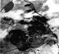
Figure 1: Steppe fire of Sumber and Khalkh gol sums Dornod aimag.

Figure 2: Fire map, Spring 1996

Figure 3: Fire mao, Spring 1997
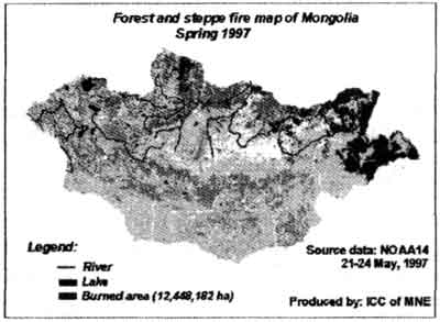
Figure 4: Fire map, Spring 1998

Figure 5: Fire map, Spring 1999
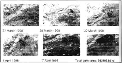
Figure 6. Steppe fire monitoring (Dashbalbar country of Dornod aimag)
3.2 Fire estimation by JERS data
Landsat, SPOT, JERS high resolution satellite data are very useful tools to estimate the burnt area and assess the fire impact to the ecology. But timely we can not buy thiskind of data, because of their high price. In 1996 NADSA of Japan had provide us by JERS satellite data for the fire estimation.
For study purpose we have used the JERS composed data from 21-24 May, 1996. The JERS data has 18 m of ground resolution which is suitable to calculate the burnt area and to integrate with GIS data.
However we can monitor the forest and steppe fire status by daily NOAA data as showed above. For the accurate assessment of the burnt area, of small area, as presented by curcle with letter A in Figure 2, of Tsagaan-Uur, Tarialan and Teshig sums of Kubsugul and Bulgan aimags, we have processed JERS composed data of channels 1,3,2 (Figure 7).
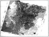
Figure 7. Burnt area by JERS composed data on 24 may 1996.
We have tried to estimate the burnt area by the Remote sensing and GIS integrated data. For this purpose used JERS satellite data and forest and selected area had 1:1000000 scale. The selected area had 266596.34 hectares, were not burnt.
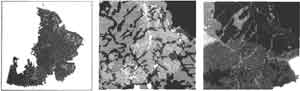
Figure 8. Burnt soil and forest condition maps.
Depending on the map scale we have estimate that 2 types of forest and 7 types of soil was burnt. In Tables 1, 2 are some statistics of burnt forest and soil characteristics.
Table 1. The Burnt forest type
| Forest type | None forest | Fir | Birch |
| Total area (ha) | 468534.83 | 608413.45 | 8439.11 |
| In selected area (ha) | 72181.02 | 192095.71 | 2319.61 |
| Not burnt area (ha) | 7036.28 | 18505.77 | 128.54 |
| Burnt area (ha) | 65144.75 | 173589.93 | 2191.07 |
Table 2. Burnt soil type
| No | 1 | 2 | 3 | 4 | 5 | 6 | 7 |
| Soil type (code number) | 22 | 25 | 26 | 101 | 193 | 194 | 205 |
| Total area (ha) | 147042.59 | 90133.50 | 308550 | 8906.44 | 21083.3 | 2735.01 | 49592.75 |
| Selected area (ha) | 34141.19 | 81637.36 | 126306 | 2108.5 | 5606.21 | 1443.69 | 15353.66 |
| Not burnt area (ha) | 6129.72 | 5669.20 | 11401.4 | 165.14 | 99.59 | 256.22 | 1949.32 |
| Burnt area (ha) | 28011.47 | 75968.15 | 114904 | 1943.36 | 5506.62 | 1187.47 | 13404.34 |
Description of soil type code:
22 – Mountain cryomorphic – taiga with mountain soddy – taiga
25 – Mountain derno – taiga with mountain cryomorphic – taiga
26 – Mountain, soddy – taiga with mountain forest dark coloured
101 – Typical chernorem with meadow cryomorphic
193 – Meadow swamp cryomorphic with swamp cryomorphic
194 – Meadow swamp cryomorphic with meadow cryomorphic
205– Meadow alluvial with alluvial weakly developed and meadow swamp alluvial
According to the above results, within the selected area included 72.1% of fir and 0.5% of birch forests and after the fire burnt 90.4% of fir forest and 94.5% of birch forest (See Table 1). From the included soil types within selected area, the Mountain forest dark coloured soil types are biggest by burnt area and Meadow swamp cryomorphic with meadow cryomorphic type is smallest. But there was 93-98% of Meadow swamp cryomorphic with meadow cryomorphic and Meadow swamp cryomorphic with swamp cryomorphic types.
Conclusion
The remote sensing system is a efficient tool for permanent control for detection and monitoring wildfires and also reducing their ecological and economical damages in the country. But there are several difficulties for establishment of early warning mechanism in order organize effectively fire agains activities. One of them is a communication system in Mongolia. Another problem is a data resolution. NOAA AVHRR data has 1.1 km resolution and it is impossible to detect small fires.
For the study of the ecological damage estimation of fire there was selected the JERS satellite data and the 1:1,000,000 scale of GIS data and tried to integrate them. If the scale of GIS data is more smaller, like 1:100,000 we have possibility to make such kind of estimation more accurately.
Reference:
- Adyasuren Ts. IDNDR Mid-term Review and the 1994 World conference on Natural Disaster Reduction. National report, 1993.
- Alcira Kreimer, Mohan Munasinghe. Managing Natural Disasters and the Environment, Washington, D.C. June 27-28, 1990.
- Erdenetuya M. Report on “Fire monitoring of Mongolia”, 1997 and 1998.
- Erdenesaikhan N. Repot on “Fire detection in Mongolia”, 1995.
- Mongolia in 21th century Socio-economic new policy, Ulaanbaatar 1997.
- Materials of National Programme on Disaster Reduction. “ENKO” Co. Ltd, Ulaanbaatar 1998.
- National Atlas of Mongolia. Mongolia, 1990.
- National Plan of Action to Combat Disasters in Mongolia, Ulaanbaatar, 1997.
- Processing of National Seminar on “Fire Prevent and the fire against activities”. Ulaanbaatar 1998.
- UN/UNDRO/ESCAP Workshop on Application of space techniques to combat
Natural Disaster, Bijing, 1991.