| GISdevelopment.net ---> AARS ---> ACRS 1999 ---> Poster Session 3 |
Study on LUCC and soil
Degradation in China by USE OF DMSP/OLS and Other Data
Jiang Qigang and Shinaro Goto
Faculty of Geo-Environment Science, RISSHO University
1700 Magechi, Kumagaya City, Saitama 360-0194, Japan
Tel: (81)-48-539-1653 Fax: (81)-48-539-1653
E-Mail:jiangqg@risgw.ris.ac.jp; got@risgw.ris.ac.jp
Jiang Qigang and Shinaro Goto
Faculty of Geo-Environment Science, RISSHO University
1700 Magechi, Kumagaya City, Saitama 360-0194, Japan
Tel: (81)-48-539-1653 Fax: (81)-48-539-1653
E-Mail:jiangqg@risgw.ris.ac.jp; got@risgw.ris.ac.jp
Used Data
DMSP/OLS data
Defense Meteorological Satellite Programs (DMSP) Operational Linescan System (OLS), the primary mission is the observation of nighttime moonlit could cover for global meteorological forecasting for Air Force. At the same time, most urban oriented city lights images are collected. In order to study "City light" and urban monitor, Marc L. Imhoff etc. (1997) put forward the thresholding technique for converting lights to urban cover. In order to ride of the blooming and noise of city light. Imhoff, etc. take the 88% as threshold, 88~100% as the real city light. In the study, we taken 88% as threshold at first, but the city area that was calculated with this threshold is overlarge comparing with actual city area. In our study, take 93% as the threshold, 93~100% as the real city light. In the study, we taken 88% as threshold at first, but the city area that was calculated with this threshold is overlarge comparing with actual city area. In our study, take 93% as the threshold, 93~100% as the real city light, considering the actual phenomenon in China. By comparing with the area calculated from this threshold phenomenon in China. By comparing with the area calculated from this threshold city light with the actual city area, they are about equal.
By the processing of ArcView, the DMSP cover area of Asia has been converted to China area (fig. 1).
Because of the limit of city area, we try to buffer the city area by city+50km, city+100 km, city+150 km, city+200 km (Fig.2), to compare and study the land use and land cover changes and soil degradation from city to city+200km.
Digitized global Atlas of Agriculture in 1960's (Fig.3)
The data was digitized in 1980's. there are 28 types of the global land uses and land cover s for agriculture in the atlas, but there are only 9 types in China area.
Land cover map of China in 1960's (Fig.4)
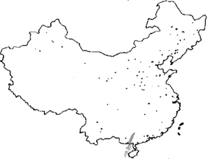
Fig. 1 DMSP City Light of China
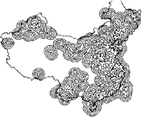
Fig.2 Buffered City, City +50, City+100
City+150, City+200 km
The land cover map of china was compiled by Prof. Tatechi and his colleges based on AVHRR NDIV data from 1992 to 1993. In the map, land covers were divided into 14 types. In order to compare with other data, the land cover types have been merged into 6 types.
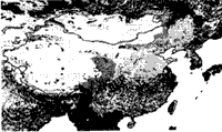
Fig. 3 Atlas of Agriculture in China in 1960's
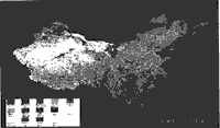
Fig.4 Land cover Map of Chna in 1960's
Global Assessment of Human Induced Soil Degradation (GLASOD, by ISRIC)
Global Assessment of Human induced Soil Degradation (GLASOD, by ISRIC) was downloaded from http://grid2.cr.usgs.gov/data/download.html.bak. In the data, the Soil Degradation was divided into 4 types: water erosion, wind erosion, chemical deterioration and physical deterioration. Each type was sub-divided into light, moderate, strong and extreme based on the degree of soil degradation, and infrequent (0~5% of the terrain affected, Value 1), common (6~10% Value 2), 5), based on the extent of soil degradation, respectively (Fig.5).
East Asia Population Data (Fig.6)
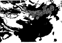
Fig.5 Human Induced Soil Degradation in China
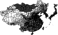
Fig 6 East Asia Population Data
The data was downloaded from the same address as mentioned above. Population, distributions, provinces, counties and their areas, codes and names etc. of the eastern Asia are included in the data. In order to comparing with other data, we have chosen China as study area.
Methodology
The analyses and calculations of various data are under the supporting of software ArcView 3.0a. The analysis and calculation method is below (Fig. 7):
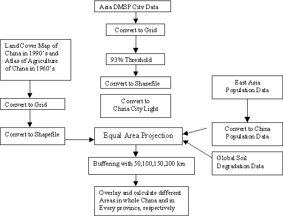
Fig.7 Analysis and calculation diagram
Data Analysis
Comparing land uses and covers maps with DMSP city light data
In order know land uses and covers within and around cities and land use and cover changes resulted from urbanization, we have compared DMSP city light data of China with Atlas of agriculture in 1960's and Land cover map of China in 1960's, overlapped and calculated the area of each type of land use and cover from city, city+50km, city=100km, city+150km to city+200km, respectively.
From Fig. 8, we can see that the area of arable land had increased from city to city+50km, but decreased from city+50km to city+200km. The area of paddy had decreased and forestland and grassland gradually increased from city+200km.
Fig.9 shows the similar change trends as Fig.8 From city to city+200km, the area of arable land and paddy gradually decreased but forestland and grassland gradually increased. Through comparing Fig.9 with Fig. 8, it is easy to get the result that in China the farmland mainly concentrates near and around city, with the distance increase form city, the area of farmland decreased; the city expansion firstly converted from arable land and paddy, and secondly converted from others in which wasteland and wetland are included. The fact that land uses and covers have been changed, but arable land and paddy still occupied a dominant position near and around cities in China and the development of cities and urbanization still were at the cost of these land areas.
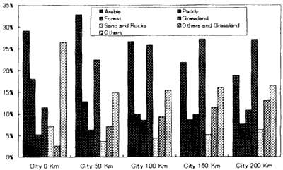
Fig.8 City~City+200km LUC in 1960's
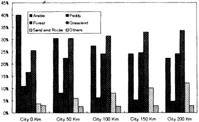
Fig.9 City~City+200km LUC in 1960's
Soil degradation in city light area
From city to city+200km in China, the major types of soil degradation were water erosion, wind erosion and chemical deterioration, physical deterioration only happened within a smaller extent. From Fig.10 we can see that from city to city +50km, no matter what type soil degradation, water erosion, wind erosion, chemical deterioration and physical deterioration, the degree and extent of soil degradation had significantly increased. But from city+50km to city to city+50km. It may be the possibility that human activities of agricultural and industrial production mainly concentrated within city +50km. In view of the causes of soil degradation in China, unreasonable agricultural activities and deforestation around city around city area were the major causes.
Comparing Atlas of Agriculture in 1960's with Land Cover Map in China 1960's, to detect the LUCC in every province in China.
Making use of Atlas of Agriculture in 1960's and Land Cover Map in China in 1990's, we overlapped those data with the China population data converted from the eastern Asia population data, and calculated the land use and cover area for every province in china in 1960's and in 1990's, respectively. From 1960's to 1990's, in whole China, the area of forestland significantly increased, grassland decreased. In agricultural land, arable land as well as paddy had slightly decreased.
In view of LUCC in every province in China from 1960's to 1990's, the area of arable land obviously increased in Inner Mongolia, Qinghai, Gansu, Ningxia, Xinjiang, Tibet, etc. regions and provinces, but decreased inJilin, Liaoning, Hebei, Shangdong, Shaanxi, jiangsu, Shanghai, Anhui, Fujian, Jiangxi Zhejiang, Huberi and Sichuan provinces and regions. The area of arable land increased in North and West China and decreased in South and East China. The area of forestland increased in Heilongjiang, Jilin, Liaoning, Beijing, Shaanxi, Jiangsu, Shanghai, Anhui, Zhejiang, Jiangxi, Hunan, Hubei, Fujian, GuangDong, Guangxi and Guizhou provinces and regions, but had slightly increased in Shanxi, Henan, Shandong, Ningxia, Gansu, and Qinghai provinces and regions, and decreased in Tibet. The area of forestland had increased in most provinces in China. The area of grassland has increased in Jilin, Liaoning, Heiloning, Heilongjiang, shaanxi provinces, but decreaed in Qinghai, Tibet, Yunnan, Henan and Hebei provinces and regions. In Gansu, Qinghai and Xinjiang regions, the areas of desert have significantly increased.
Soil Degradation
A large scale of economic construction industrial and agricultural production in China since, 1949, especially after taking the open policy in 1978, because there lacked of related environmental protective measures, farmland had been annually cultivated without interrupted. It made the soil seriously degrade, the surface soil, which is rich in organic and nutritive matter had been eroded, and ill irrigation had resulted in salinization.
By overlapping of GLASOD data with population data of China, to calculate the area, the degree, the extent and the causes of each type soil degradation in every province. In China, wind erosion mainly happened in north China, concentrated in northest and northwest China (Fig.11) and the extent of wind erosion were moderate to common in most provinces, the major causes of wind erosion belonged to the agricultural activities, deforestation and overgrazing.
Water erosion happened in every province to some extent in china, but the strongest provinces were Hebei province and Tianjin city in north China, the secondary provinces were Jilin and Liaoning provinces in northeast China, the third were provinces located in coastal region in southeast China (Figs. 12 and 13).
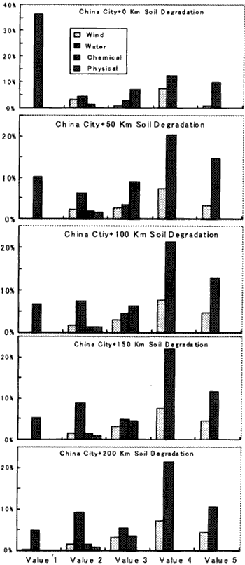
Fig.10 soil degradation from City to City +200km in China
The causes of water erosion were deforestation and agricultural activities, unreasonable irrigation, overusing groundwater, and it made the soil salinization commonly happen in north China. In northeast China, the major cause of water erosion was overgrazing. The major causes in northwest China is deforestation and in southeast China deforestation and agricultural activities.
Chemical deterioration mainly happened in Hebei, Tianjin, Henan, Xinjiang, Gansu, and Inner Mongolia, and in which Hebei province was the most seriously province suffered the chemical deterioration, the secondary provinces ere henna, Shangdong and Xinjiang (Fig.14). The causes of chemical deterioaration wee unreasonable agricultural activities, overuse groundwater, irrigation and related salinization, etc.
The physical deterioration was limited to Anhui, Henan and Jiangsu provinces; the cause was agricultural activities.
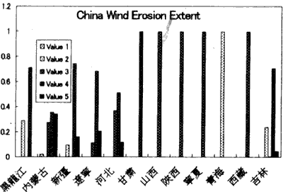
Fig. 11 Wind Erosion in China
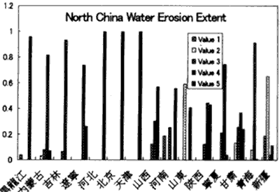
Fig. 12 Water Erosion in North China
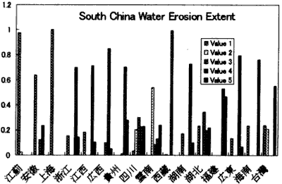
Fig. 13 Water Erosion in South China
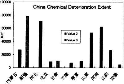
Fig.14 Chemical Deterioration in China
Conclusion
Form the research results, we can get conclusion that in China with economic development, land uses and covers and related environment had greatly been changed. How to rational use land resource and protect the environment as well as keep sustainable development, it is the most important problem that Chinese people has to copy with. In view of analysis and calculated results, most of the results are has to copy with. In view of analysis and calculated results, most of the results are consistent with the actual situation. Because of the data belongs to different periods and the difference of the classification criterion, some results are consistent with the actual situation.
References
DMSP/OLS data
Defense Meteorological Satellite Programs (DMSP) Operational Linescan System (OLS), the primary mission is the observation of nighttime moonlit could cover for global meteorological forecasting for Air Force. At the same time, most urban oriented city lights images are collected. In order to study "City light" and urban monitor, Marc L. Imhoff etc. (1997) put forward the thresholding technique for converting lights to urban cover. In order to ride of the blooming and noise of city light. Imhoff, etc. take the 88% as threshold, 88~100% as the real city light. In the study, we taken 88% as threshold at first, but the city area that was calculated with this threshold is overlarge comparing with actual city area. In our study, take 93% as the threshold, 93~100% as the real city light. In the study, we taken 88% as threshold at first, but the city area that was calculated with this threshold is overlarge comparing with actual city area. In our study, take 93% as the threshold, 93~100% as the real city light, considering the actual phenomenon in China. By comparing with the area calculated from this threshold phenomenon in China. By comparing with the area calculated from this threshold city light with the actual city area, they are about equal.
By the processing of ArcView, the DMSP cover area of Asia has been converted to China area (fig. 1).
Because of the limit of city area, we try to buffer the city area by city+50km, city+100 km, city+150 km, city+200 km (Fig.2), to compare and study the land use and land cover changes and soil degradation from city to city+200km.
Digitized global Atlas of Agriculture in 1960's (Fig.3)
The data was digitized in 1980's. there are 28 types of the global land uses and land cover s for agriculture in the atlas, but there are only 9 types in China area.
Land cover map of China in 1960's (Fig.4)
Fig. 1 DMSP City Light of China
Fig.2 Buffered City, City +50, City+100
City+150, City+200 km
The land cover map of china was compiled by Prof. Tatechi and his colleges based on AVHRR NDIV data from 1992 to 1993. In the map, land covers were divided into 14 types. In order to compare with other data, the land cover types have been merged into 6 types.
Fig. 3 Atlas of Agriculture in China in 1960's
Fig.4 Land cover Map of Chna in 1960's
Global Assessment of Human Induced Soil Degradation (GLASOD, by ISRIC)
Global Assessment of Human induced Soil Degradation (GLASOD, by ISRIC) was downloaded from http://grid2.cr.usgs.gov/data/download.html.bak. In the data, the Soil Degradation was divided into 4 types: water erosion, wind erosion, chemical deterioration and physical deterioration. Each type was sub-divided into light, moderate, strong and extreme based on the degree of soil degradation, and infrequent (0~5% of the terrain affected, Value 1), common (6~10% Value 2), 5), based on the extent of soil degradation, respectively (Fig.5).
East Asia Population Data (Fig.6)
Fig.5 Human Induced Soil Degradation in China
Fig 6 East Asia Population Data
The data was downloaded from the same address as mentioned above. Population, distributions, provinces, counties and their areas, codes and names etc. of the eastern Asia are included in the data. In order to comparing with other data, we have chosen China as study area.
Methodology
The analyses and calculations of various data are under the supporting of software ArcView 3.0a. The analysis and calculation method is below (Fig. 7):
Fig.7 Analysis and calculation diagram
Data Analysis
Comparing land uses and covers maps with DMSP city light data
In order know land uses and covers within and around cities and land use and cover changes resulted from urbanization, we have compared DMSP city light data of China with Atlas of agriculture in 1960's and Land cover map of China in 1960's, overlapped and calculated the area of each type of land use and cover from city, city+50km, city=100km, city+150km to city+200km, respectively.
From Fig. 8, we can see that the area of arable land had increased from city to city+50km, but decreased from city+50km to city+200km. The area of paddy had decreased and forestland and grassland gradually increased from city+200km.
Fig.9 shows the similar change trends as Fig.8 From city to city+200km, the area of arable land and paddy gradually decreased but forestland and grassland gradually increased. Through comparing Fig.9 with Fig. 8, it is easy to get the result that in China the farmland mainly concentrates near and around city, with the distance increase form city, the area of farmland decreased; the city expansion firstly converted from arable land and paddy, and secondly converted from others in which wasteland and wetland are included. The fact that land uses and covers have been changed, but arable land and paddy still occupied a dominant position near and around cities in China and the development of cities and urbanization still were at the cost of these land areas.
Fig.8 City~City+200km LUC in 1960's
Fig.9 City~City+200km LUC in 1960's
Soil degradation in city light area
From city to city+200km in China, the major types of soil degradation were water erosion, wind erosion and chemical deterioration, physical deterioration only happened within a smaller extent. From Fig.10 we can see that from city to city +50km, no matter what type soil degradation, water erosion, wind erosion, chemical deterioration and physical deterioration, the degree and extent of soil degradation had significantly increased. But from city+50km to city to city+50km. It may be the possibility that human activities of agricultural and industrial production mainly concentrated within city +50km. In view of the causes of soil degradation in China, unreasonable agricultural activities and deforestation around city around city area were the major causes.
Comparing Atlas of Agriculture in 1960's with Land Cover Map in China 1960's, to detect the LUCC in every province in China.
Making use of Atlas of Agriculture in 1960's and Land Cover Map in China in 1990's, we overlapped those data with the China population data converted from the eastern Asia population data, and calculated the land use and cover area for every province in china in 1960's and in 1990's, respectively. From 1960's to 1990's, in whole China, the area of forestland significantly increased, grassland decreased. In agricultural land, arable land as well as paddy had slightly decreased.
In view of LUCC in every province in China from 1960's to 1990's, the area of arable land obviously increased in Inner Mongolia, Qinghai, Gansu, Ningxia, Xinjiang, Tibet, etc. regions and provinces, but decreased inJilin, Liaoning, Hebei, Shangdong, Shaanxi, jiangsu, Shanghai, Anhui, Fujian, Jiangxi Zhejiang, Huberi and Sichuan provinces and regions. The area of arable land increased in North and West China and decreased in South and East China. The area of forestland increased in Heilongjiang, Jilin, Liaoning, Beijing, Shaanxi, Jiangsu, Shanghai, Anhui, Zhejiang, Jiangxi, Hunan, Hubei, Fujian, GuangDong, Guangxi and Guizhou provinces and regions, but had slightly increased in Shanxi, Henan, Shandong, Ningxia, Gansu, and Qinghai provinces and regions, and decreased in Tibet. The area of forestland had increased in most provinces in China. The area of grassland has increased in Jilin, Liaoning, Heiloning, Heilongjiang, shaanxi provinces, but decreaed in Qinghai, Tibet, Yunnan, Henan and Hebei provinces and regions. In Gansu, Qinghai and Xinjiang regions, the areas of desert have significantly increased.
Soil Degradation
A large scale of economic construction industrial and agricultural production in China since, 1949, especially after taking the open policy in 1978, because there lacked of related environmental protective measures, farmland had been annually cultivated without interrupted. It made the soil seriously degrade, the surface soil, which is rich in organic and nutritive matter had been eroded, and ill irrigation had resulted in salinization.
By overlapping of GLASOD data with population data of China, to calculate the area, the degree, the extent and the causes of each type soil degradation in every province. In China, wind erosion mainly happened in north China, concentrated in northest and northwest China (Fig.11) and the extent of wind erosion were moderate to common in most provinces, the major causes of wind erosion belonged to the agricultural activities, deforestation and overgrazing.
Water erosion happened in every province to some extent in china, but the strongest provinces were Hebei province and Tianjin city in north China, the secondary provinces were Jilin and Liaoning provinces in northeast China, the third were provinces located in coastal region in southeast China (Figs. 12 and 13).
Fig.10 soil degradation from City to City +200km in China
The causes of water erosion were deforestation and agricultural activities, unreasonable irrigation, overusing groundwater, and it made the soil salinization commonly happen in north China. In northeast China, the major cause of water erosion was overgrazing. The major causes in northwest China is deforestation and in southeast China deforestation and agricultural activities.
Chemical deterioration mainly happened in Hebei, Tianjin, Henan, Xinjiang, Gansu, and Inner Mongolia, and in which Hebei province was the most seriously province suffered the chemical deterioration, the secondary provinces ere henna, Shangdong and Xinjiang (Fig.14). The causes of chemical deterioaration wee unreasonable agricultural activities, overuse groundwater, irrigation and related salinization, etc.
The physical deterioration was limited to Anhui, Henan and Jiangsu provinces; the cause was agricultural activities.
Fig. 11 Wind Erosion in China
Fig. 12 Water Erosion in North China
Fig. 13 Water Erosion in South China
Fig.14 Chemical Deterioration in China
Conclusion
Form the research results, we can get conclusion that in China with economic development, land uses and covers and related environment had greatly been changed. How to rational use land resource and protect the environment as well as keep sustainable development, it is the most important problem that Chinese people has to copy with. In view of analysis and calculated results, most of the results are has to copy with. In view of analysis and calculated results, most of the results are consistent with the actual situation. Because of the data belongs to different periods and the difference of the classification criterion, some results are consistent with the actual situation.
References
- Marc L.Imhoff, etc. A Technigue for Using Composite DMSP/OLS "City
Light" Satellite Data to Map Urban Area. REMOTE SENS. ENVIRON.
61:361-370(1997)
- Wu Chuanjun, etc. land Use in China (Chinese), (1994)
- http://grid2.cr.usgs.gov/data/download.html.bak
- http://oblbwww.cu.noda.sut.ac.jp/awlc/index.htm