| GISdevelopment.net ---> AARS ---> ACRS 1999 ---> Poster Session 3 |
Soil Moisture Determination
Under Different Field conditions Using a Scatterometer and Space Borne SAR
Systems
Shakil A. Romshoo, T. Nakaegawa, Masahiro Koike and Katumi Musaike
Mushiake lab, IIS, University of Tokyo, 7-22-1, Roppongi, Minato-ku, Tokyo-106,
Tel: (81)-3-3402-6231 ex. (2527), Fax: (81)-3-3402-2597
E-Mail:shakil@water.iis.u-tokyo.ac.jp
Shakil A. Romshoo, T. Nakaegawa, Masahiro Koike and Katumi Musaike
Mushiake lab, IIS, University of Tokyo, 7-22-1, Roppongi, Minato-ku, Tokyo-106,
Tel: (81)-3-3402-6231 ex. (2527), Fax: (81)-3-3402-2597
E-Mail:shakil@water.iis.u-tokyo.ac.jp
Soil moisture is an environmental descriptor that that integrates much of the land surface hydrology and is the interface for interaction between the solid Earth surface and life. It is a difficult variable to measure, not at one point in time, but in a consistent and spatially comprehensive basis. Much of out failure to translate the under-standing of point measurements to natural land-scapes c n be traced to a realization that soil moisture varies greatly in space with no obvious means to measure it. Remote sensing radar imaging systems with their all weather capability are a promising tool for data acquisition on a regular basic. For soil moisture, recent advances in remote sensing technology have demonstrated that soil moisture can be measured by a variety of techniques (Engman and Chauhan, 1995). How ever, only microwave technology has the ability to quantitatively measure soil moisture under a variety of topographic and vegetation cover conditions, so potentially it could be extended to routine measurements from a satellite system (Eng-man and Chauhan, 1995).
A number of experiments using sensors mounted in trucks, aircrafts, and space-crafts have shown that the moisture within a thin layer of soil on the order of 5 cm, can be accurately measured for bare soil and thinly vegetated surfaces. Earlier work by Ulaby (1974), using a ground Scatterometer, suggested that a C-band radar operating angles between 10o
and 20o would be optimal for soil moisture extraction in the top 0.5 cm soil layer as the roughness effects could be minimized. Using a C-band Scatterometer measurement of a tall-grass prairie, Martin et al. (1989) observed that viewing angles Martin et al. (1989) observed that viewing angles of 30o and 45o also produced strong correlations with soil moisture. The capability to measure soil moisture from a space platform was also demonstrated qualitatively with SEASAT SAR data (Blanchard and Chang, 1983) and quantitatively through experiments with shuttle Imaging Radar SIR-B, carrying a L-band SAR system (Dobson and Ulaby, 1986a)
The objective of this research has been to explore the possibilities of temporal analysis of soil moisture change detection under different conditions using the ground based and space borne Synthetic Aperture Radar (SAR) systems and also to analyze and understand the influences of the vegetation on the s0 sensitivity to the soil moisture detection. For temporal analysis of soil moisture using radar images, it is desirable to examine a period over which marginal changes in roughness and vegetation are expected.
Study Areas
The study has been conducted in different fields under varied surface conditions. Three fields located at different areas in Chiba prefecture, Japan viz., Kemigawa, located at 35.67o north latitude and 140.08o east longitude, Futawa., located at 35.30o north latitude and 139.31o east longitude and Inbanuma were chosen for the study. The former two, comprising a number of play grounds, each were selected for the field campaigns during the RADARSAT over pass over these areas while as the later located at 35.74o north latitude and 140.20o east longitude was selected for the soil moisture determination under paddy field conditions. The dimensions of the Kemigawa and Nihon fields were 17.76 ha and 3.56 ha respectively while as that of paddy field were 100m *200m. The topography of these fields is quite flat. The soil types of the fields are Narita soils. The two fields chosen for RADARSAT campaign have a composite land use of both bare and grass areas which did not change much during the campaign period. The Nihon field was comparatively roughter than Kemigawa fields.
Scatterometer System
The Scatterometer employed in collecting the data in this study is the 5.2 GHz microwave active Scatterometer (5.8 cm wavelength). This is a mobile van-mounted system capable of making scattering measurement at a single frequency (C-Band) and employs a dual antenna system con-figured to allow all the linear polarization modes of operation. Measurements can be made at angles of incidence from zero degrees (nadir) to 70degrees. The details of the system specifications and characteristics can be found from Musiake et al., (1987). During the experiments coinciding with the RADARSAT revisits, The measurements were recorded at HH polarization and 23o and 35o incidence angles compared to the RADARSAT sensor configuration of HH polarization and 21o-27o angles of incidence in the standard beam mode (SI). In case of paddy field, the measurements were also recorded at 43oincidence angle in addition to the other two angles. The choice of the active microwave radar sensors on board the space platforms like ERS and JERS satellite systems.
Fields Data Collection
The field campaign for the RADARSAT in two fields viz kemigawa and Nihon Univ. was conducted six times with the first one starting on 15 May, 97 and the last one conducted on 17 Dec., 97. In addition to measuring the volumetric soil moisture and Time domain reflectometry (TDR) during these campaigns, the C-band Scatterometer was also used during the campaign. In case of soil moisture determination under paddy crop, besides measuring the surface characteristics like soil moisture by volumetric and TDR means, rms height, the plant parameters like LAI, density and height, of plants were also recorded in the field. The paddy crop was raised in this field by planting the seeds in rows rather than the transplanting the seeds in rows rather than the transplanting of the seedlings which is a common practice all over the globe. The tillage practice in the area is concerned. The gaps in the time history of data are either due to system faults or due to the flooded field conditions.
Satellite Data-Sets Used
In all, six RADARSAT scenes of standard beam mode were used for two sites i.e. Kemigawa and a C-band SAR system with a frequency of 5.4 GHz and HH polarization with incidence angle ranging from 21o - 27o across the swath of the standard beam (SI) images. The RADARSAT data for the following days of 1997. was used: May 5, 15, May 18, July 16, August 9 and August 19. Each scene covers a minimum ground swath of 100 Km square. The nominal spatial resolution in the range direction is 26m for the S1 mode at near range. The azimuth resolution is 27 m. the product has pixel dimensions of 12.5 m and are a result of processing of four independent azimuth samples, or four independent azimuth samples, or four looks, in the along track antenna beam dwell time and then non-coherently summing of the coherent speckle noise in the image to provide improved radiometric resolution.
Table 2: Summary of correlation coefficients (r) and slope of so for Scatterometer and RADARSAT at Kemigawa and Nihon Univ. fields.
| Fields | Inci. Angle | Scatterometer | Radarsat | ||
| r | slope | r | slope | ||
| Kemigawa | 23o | .87 | .70 | .85 | .72 |
| 35o | .73 | .45 | - | - | |
| Nihon Univ. | 23o | .69 | .31 | .77 | .33 |
| 35o | .73 | .25 | - | - | |
Processing Radar Images
The RADARSAT SFG products were geo-rectified and projected to Universal Transverse Mercator (UTM). A num er of filters were tested to suppress the speckle on the image and at the same time ensuring the minimum degradation of the pixle resolution. Out of all the filters tested, The GAMA-MAP filter was found the best one after checking for the coefficient of variation and the image degradation visually. This filter maximizes the a posterirori probability density function and attempts to derive the original value which must lie between the local average and the degraded pixel value. The intensity images were converted to the so (sigma nought) values by reversing the scaling Look Up Table (LUT) which additionally requires the knowledge of the incidence angles over the image swath (Shephered, 1998). This was done to reduce the dynamic range of the values. Then the arc/info coverage of the fields, digitized from the topographical maps, were used to cut out the field boundaries of the two sites from each of the images and an average of the pixel values in the subset image was calculated.
Table 3: Summary of correlation coefficients and slope of so with soil moisture and plant parameters at Inbanuma paddy field.
(a)*
| Polarisation | Inci. Angle | Bare Cond. | Veg. Cond. | ||
| r | slope | r | slope | ||
| VV | 23o | .20 | .11 | - | - |
| VV | 35o | .56 | .23 | - | - |
| VV | 43o | .84 | .34 | - | - |
| HV | 23o | .84 | .61 | .74 | .39 |
| HV | 35o | .89 | .78 | .83 | .58 |
| HV | 43o | .95 | .87 | .87 | .64 |
(b)*
| Polarisation | Inci. Angle | Plant Height | LAI | ||
| r | slope | r | slope | ||
| HH | 43o | .75 | .14 | .78 | 1.4 |
| VV | 43o | .57 | .07 | .74 | .93 |
| HV | 43o | .63 | .11 | .75 | .63 |
(b)* shows relationships with plant parameters.
Data Analysis
The data from the C-band Scatterometer and field campaigns, from Kemigawa and Nihon-Diagaku fields, along, with the RADARSAT image products have been analyzed together to find the change detection of soil moisture over the observation period without any consideration for the surface roughness and vegetation effects. These fields had almost static land cover and roughness characteristics during the observation period, with little bit of grasses cropping up and drying down in between the observations. The vegetation biomass, when present, was very low and almost static. So can be said about the roughness characteristics of the fields. The volumetric and TDR observations were recorded at the same time, the Scatterometer was being used for soil moisture sensing at two angles of incidence i.e. 23o and 35o with only HH polarization. Fig. 1 shows the sensitivity of the so observed by the Scatterometer for the Nihon Univ. field while as the Fig. 2 shows it for the Kemigawa field. Fig 3 shows the sensitivity of the so to soil moisture observed from the RADARSAT images to the observed soil moisture in the Kemigawa and Nihon Univ. (Futawa) fields. In case, we segrgate the measurements for the bare and the short vegetation fields in case of Nihon Univ. (Futawa), we get better correlation and sensitivity to soil moisture. The correlation coefficients along with the sensitivity for each angle at either place both from Scatterometer and RADARSAT images are given in the table 1. The sensitivity of so to soil moisture does decrease with the increase of incidence angles in case of the scatterometer at both the fields. The relationship and sensitivity is better for the kemigawa field than for the Nihon Univ. (Futawa) field. Both in case of Scatterometer and the RADARSAT data. Such a behavior is probably due to the rougher surface conditions and more intense vegeation at Nihon university field than for Kemigawa field. Both these conditions reduce the correlation and sensitivity of the so to soil moisture (Altese et. al, (1996), Ulaby et. al (1979)).
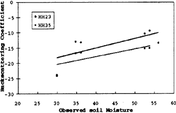
Fig.1 Time series sensitivity of Scatterometer so to vol. Soil moisture for two incidence angles at Nihon University field (Futawa).
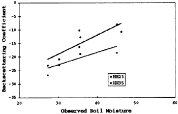
Fig.2. Time series sensitivity of Scatterometer so to vol. Soil moisture for two incidence angles at Kemigawa field.
In order to understand the influence of the vegeation on the soil moisture determination, a separate experiment was conducted on the paddy field at Inbanuma. The soil moisture was monitored in the field 10 times right fromt eh planting of the paddy seeds in the field in April 98 till harvesting of the crop in Oct., 98. Since the paddy is raised from the seeds, there is no obligation to mintain a flooded water conditions during the early stages of the crop. Because of this reason, the so to observed by the Scatterometer in the initial stages of the crop growth is sensitive to the soil moisture at all the incidence angles tested this experiment for all the polarization as can be seen from the fig. 6 for VV polarization and the three incidence angles. Similar type of response is observed for HH polarizations. Even stronger correlations and sensitivity are found in case of cross-polarization (HV). This may be due to the effects of multiple surface scattering. Based on 9-Ghz observations of Kanto loam, Hirozawa et al. (1978) has also reported that the cross-polarized radar sensitivity to near-surface volumetric soil moisture is four times that of like-polarized backscattering. From Fig. 6, it can be seen that the so is responding well to the observed soil moisture changes in the field. The flooded condition in the field is well predicted by the Scatterometer due to the specular reflection on this data. There is no soil moisture measurement on 53rd day after planting due to super saturation of the soil in the field.
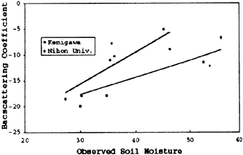
Fig.3. RADARSAT sensitivity of so to soil moisture at Kemigawa and Nihon Univ. (Futawa) fields.
But as the biomass of the crop gets increased, the so, except for the cross polarization (HV), is no more sensitive to the soil moisture as can be seen from fig. 6. On the 106th day after planting, the flooded condition on the field can not be detected by the Scatterometer because the volume and biomass of the crop has increased tremendously since the first flooding which could be clearly detected by the Scatterometer. The biomass and the height of the crop on this particular day is 2.84 cm and 93 cm respectively. The soat HV polarization gives reasonable correlation and sensitivity with respect to soil moisture for all the angles of incidences as can be seen from Fig. 5 and are detailed in table 2. Similar type of finding has been observed by Dobson and Ulaby finding has been observed by Dobson and Ulaby (1986b). They state that there is strong, but not conclusive, evidence to indicate that HV polarization will yield superior performance to HH polarization for soil moisture retrieval.
So, it is not the soil moisture which is responding to the so, what is it the? The vegetatation parameter have been found to be sensitive to the observed so. Though a good correlation has been found between so and the plant height but the sensitivity is week. We could not measure the plant water content in the field due to the private ownership of the land which required physical de-struction of the crop. Through plant water content is a good indicator of plant physical state, the leaf area index (LAI) is a parameter that better characterizes plants for agriculture applications since it is representative of photosynthesis (Paloscia et. al., 1988). Fig. 7 depicts the correlation and the sensitivity of the so to the leaf area index. It shows stronger sensitivity and correlation with so than the plant height. Similar findings have been reported by Toan et. al. (1997) and Kurosu et. al. (1995). Table 3 shows the relationships between the so and the soil moisture during the initial stages of the paddy growth and the relationship of the so with the plant parameters as the plant gains in height and biomass. The cor-
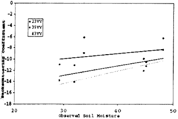
Fig. 4. Sensitivity of Scatterometer so to soil moisture under comparatively bare conditions at all angles and VV polarization.
Furthers more, since the plants are raised in rows the row structure has a prominent effect in the initial stages of the crop but as the crop attains height and higher biomass, the crop looses the row structure and this effect vanishes. It has been observed that the that the cross-polarization is les sensitive to the row structure than the co-polarized signals. The difference in magnitude of the signal due to row configuration is higher in the initial stage of the growth of the plant than the final stage when the row configuration is almost lost. Fields with row direction perpendicular to the look angle give a stronger signal than if the row direction is parallel. The backscattering response is polarization dependent with the bare fields being more sensitive to the vertical polarization While as the vegetated fields are sensitive to the horizontal polarization. This type of behavior has been observed for all the incidence angles in case of co-polarization signals. We can observe this polarization dependence behavior from the Fig. 6 where the vertical polarization response is dominat as long as the crop surface is basr or bears little vegetation and after that, as the biomass of the crop increase, the horizontal polarization response is higher than the vertical one. Paloscia and Pampaloni (1988) have also shown that microwave emission from vegetated soils is partially polarized and does changes as vegetation grows. They used this variation to develop the polarization index.
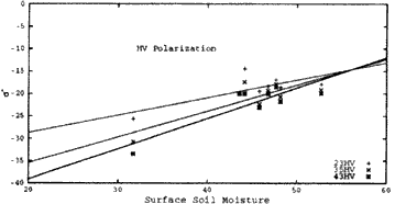
Fig5. Sensitivity of so as a function of observed soil moisture at HV polarization and all the three incident angles.
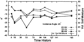
Fig.6 Time history of so and soil mosture of paddy at 23o incidence angles for HH, VV and HV polarizations
Conclusion
It has been demonstrated that temporal monitoring of soil moisture determination is possible with reasonable certainty under different field conditions with out any consideration of the vegetation and roughness components. This is based on the basic premise that only changing variable is the soil moisture that only changing variable is the soil moisture under the conditions while as the surface roughness and the vegetation parameters are supposed to be constant during the period of the campaign or are changing at show pace so as to have insignificant impacts on the so. This type of analysis can also be accomplished on a large area by analyzing a time series of the space borne SAR data with the concomitant ground truth about surface soil moisture. This is possible because the fields have been left undisturbed during the period and only a small biomass of grass has been appearing in between and vanishing again. In actual practice, the agricultural fields may not fulfill this conditions under cultivation. In such case, the vegetation component is dynamically changing while as the roughness may be regarded more or less constant. This has been proved by soil moisture monitoring from the paddy fields.
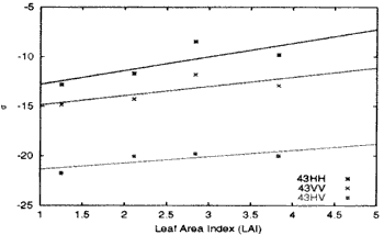
Fig.7 Sensitivity of so as function of leaf area index for all the polarizations and 43o angel of incidence.
Thought, in the initial stages of the paddy crop growth, when the soil layer is quite visible to the Scatterometer, we do find some relationship between the soil moisture and the so. As the crop gains in height and biomass, the so gets insensitive to the field soil moisture and in turn, the plants parameters especially the LAI, which is an important indicator of the growth of vegetation, become sensitive to the backscattering phenomena. The observed variations of so with paddy growth is an indirect representation of the backscattering response to the changes in plant morphology and phenology (Shakil et al. 1999). In order to determine the soil moisture independent of the roughness and vegetation, these components will have to be segregated using the oretical surface and volume scattering modeling approaches.
References
- Elio altese, O.Bologani, m. Mancini and P.a. Troch (1996).
Retrieving soil Moisture over bare soil from ERS-1 synthetic aperture
radar data: Sensitivety analysis based on a theoretical surface
scattering model and field data. Water Res. Research, Vol. 32, pp.
653-661.
- Blanchard, A.J., and A.T.C. Chang (1983). Estimation of soil
moisture from SEASAT SAR data. Water Res. Bull., vol. 19, pp.
803-810.
- Dobson , M.C., and F.T. Ulaby (1986a). Preliminary evaluation of the
SIR-B response to soil moisture, surface roughness and crop canopy
cover. IEEE Trans. Geosci. Rem. Sens., Vol. 24, No. 4, pp. 517-526.
- Dobson, M.C., and F.T. Ulaby (1986b). Active microwave soil moisture
research. IEEE Trans. Geosci. Rem. Sens., Vol. 24, No. 1, pp. 23-35.
- Engman, Edwin, T. and Narinder Chauhan (1995). Status of microwave
soil moisture measurements with remote sensing. Remote sensing of
Environment, Vol. 51, pp. 189-198.
- Hirosawa, H., Komiyama, S, and Matsuzaka, Y., (1978).
Cross-polarized radar backscatter from moist soil. Remote Sensing of
Environement, Vol. 7, No. 3, pp. 211-217.
- Kurosu, Takashi, Masaharu Fujita, and kazuo Chiba (1995). Monitoring
of rice crop growth from space using the ERS-1 C-band SAR. IEEE Trans.
Geosci. Rem. Sens. , Vol. 33, No. 4, pp. 1092-1096.
- Martin, R.D. Jr., A. Ghanssem and E.T. Kanemasu (1989). C-band
Scatterometer Measurements of a tall grass prairie, Remote sensing of
Environment, Vol. 29, pp. 281-292.
- Musiake Katumi, T. Nakaegawa, M. Koike and T. Oki (1997). Soil
moisture measurement using active microwave remote sensing-II outdoor
experiment, Journal of Japan Soc. Hydrol. And Water Resour., Vol. 10,
No. 6, pp. 588-586.
- Paloscia, A. Romshoo, Loike, M., Nakaegawa, T., Hironaka, S., and
Mushiake, Katumi (1999). Monitoring the paddy crop growth ghrough active
microwave radar : possibilities and difficulties, proceedings of the
joint conference of JSPERS and RSSJ, Chiba University, Tokyo, Japan.
- Shephered, A. Romshoo, Koike, M., Nakaegawa, T., Hironaka, S., and
Mushiake, Katumi (1999). Monitoring the padddy crop growth through
active microwave radar: possibilities and difficulties microwave radar:
possibilities and difficulties, proceedings of the joint conference of
JSPERS AND RSSJ, Chiba University, Tokyo, Japan.
- Shephered, Nick (1998). Extraction of beta nought and sigma nought
from RADARSAT CDPF products. Report No.: AS 97-5001, ALTRIX
systems,Ottawa, Ontario, Canada.
- Toan T.Le, F. Ribbes, Li-Fang Wang, N. floury, K. Takashi, M. Fujita
et al., (1997). Rice crop mapping and monitoring using ERS-1 data based
mapping and monitoring using ERS-1 data based on experiments and
modeling results IEEE Trans. Geosci. Rem. Sens., vol. 35, No. 1, pp.
41-56.
- Ulaby, F.T. (1974). Radar measurements of soil moisture content.
IEEE Trans. on Antennas Propagation, vol. AP-22(2), PP 27-265.
- Ulaby, F. T. G.A. Bradley and M.c. Dobson (1979). Microwave backscatter dependence on surface roughness, soil moisture and soil texture: Part II-bare soil. IEEE Trans. on Geosci. Rem. Sens. Vol. 16, pp. 286-295.