| GISdevelopment.net ---> AARS ---> ACRS 1999 ---> Poster Session 3 |
Assessment of Thermal
Characteristics for different Land Cover Types using NOAA AVHRR Data
Jun Arita, Krishna Pahari,
Youshifumi Yasuoka
Institute of Industrial Science, Univresity of Tokyo
4-6-1, komaba, Meguro-ku Tokyo 153-8505 Japan
Fax Tel: (81)-3-5452 -6417
E-mail: arita@skl.iis.u-tokyo.ac.jp
Keywords:
deforestation, NOAAAVHRR, thermal band, band-use, temperature
Institute of Industrial Science, Univresity of Tokyo
4-6-1, komaba, Meguro-ku Tokyo 153-8505 Japan
Fax Tel: (81)-3-5452 -6417
E-mail: arita@skl.iis.u-tokyo.ac.jp
Abstract
Large-scale deforestation has been a serious global environmental issue. It has been pointed out that large-scale changes in land cover conditions due to deforestation might give serious impact to local climatic characteristics including precipitating or temperature. However, it has not been fully investigated how the changes in land cover affect to local climate. In this study, taking the area around Thailand as the study area, fluctuations in land surface temperature for different land cover types were analyzed to asses the thermal characteristics of land surface by using NOAA AVHRR data and land-use data.
1.Introdution
Large-scale deforestation has been a serious environment issue, and it has been pointed out that the large-scale land cover change might give impact to local climate including the changes in precipitation or in temperature. However, the quantitative relations between the deforestation and the local climate have not been fully investigated. The objective of this study is to assess the impact of land cover change such as deforestation or land use change to local climate, in particular, surface temperature characteristics.
Taking the area around Thailand as the case study area, fluctuations in land surface temperature at day and night were analyzed for different land cover types by NOAA thermal band data and land use data. Land surface temperature at day and night was evaluated from AVHRR Band 3,4 and 5 data from day and night, and land cover data was obtained from land use data from the Land Development Department of Thailand which included 13 classes. The difference areas, and showed the impact of deforestation to local climatic conditions.
2.Methodoloy
21.Data used
Day and night time NOAA AVHRR thermal band data (band3, 4, 50 received in December 1998 covering Thailand area are used to evaluate land surface temperature. Each pixel size of AVHRR is around 1.1 km x 1.1 km. Land use map(1) inThailand including thirteen categories (1; urban, 2: Mine, 3: Paddy, 4:Crop, 5:Orchard, 6:Plantation, 7:mangrove, 8:ldle Land, 9:Water, 10: Fish/Shrimp Farm, 11:Forest, 12: Grasland, 13:Others) is also used to assess surface temperature dependency on land cover types. The original land use map is produced by Land Development Deparment of Thailand in 1990 and is a scale of 500,000. It is digitized into a digital into a digital land map with a grid of 200 m x 200 m (Fig.1).
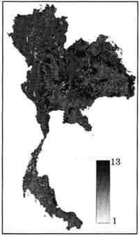
Fig .1 Land use Map of Thailand, 1990
2.2 Registration
Geometrical rectification of night time NOAA AVHRR thermal band data and land-use in Thailand was made by polynomial transformation, using more than five ground points on the coast line, using day time NOAA AVHRR thermal band data which was rectified using UTM map projections. Since the pixel size of these data are different, the pixel size of land-use data (200 x 200m) is resampled to that of the NOAA AVHRR data (1.1 km x 1.1 km) using majority data as the value for the pixel after transformation.
2.3 Calculation of surface temperature
The difference in temperature between day and night is calculated using the NOAA AVHRR thermal band data as follows;
DTi = Tdi -Tni (1)
DTi: the difference of temperature between day and night for each pixel of band i
Tdi = day time temperature for each pixel of band i
Tni : night time temperature for each pixel of band i.
For each category of land use, distribution and average of DTi is calculated for band 34 and 5 in NOAA AVHRR.
3. Assessment of thermal characteristics for different land cover types
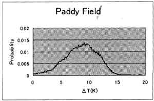
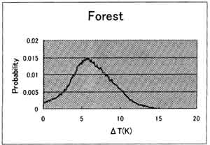
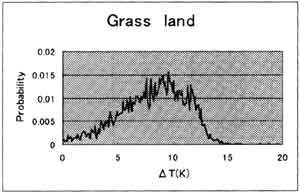
Table 1 indicates the average temperature for different land cover categories which is calculated from AVHRR band 4. In Table 4 parameters Td4 and Tn4 show the temperature at day and night derived from AVHRR band 4, and DT4 shows the temperature difference between day and night. The result for each band has similar tendency, so only the result for band4 is shown as an example. Figure 2 describes the histogram of the surface temperature for paddy, forest and Grass land. In Table 1 and Fig. 2 is clearly indicated that the forest area has low temperature difference between day and night. However, the results for categories such as urban, Mine, Orchard, Water, Fish/Shrimp farm are not satisfactory enough, probably because of coarse spatial resolution, and because of the miss registration.
| Average | |||
| Category | Td4 (°C) | Tn4 (°C) | DT4 (°C) |
| Urban | 24.5 | 19.9 | 5.6 |
| Mine | 24.1 | 19.8 | 5.5 |
| Paddy | 28.7 | 20.4 | 8.4 |
| Crop | 28.8 | 20.0 | 8.9 |
| Orchard | 26.0 | 20.0 | 6.6 |
| Plantation | 22.8 | 18.2 | 5.9 |
| Mangrove | 25.4 | 19.6 | 6.4 |
| Idle land | 26.0 | 19.5 | 6.8 |
| Water | 25.9 | 19.6 | 6.6 |
| Fisth/Shrimp farm | 25.5 | 19.4 | 6.3 |
| Forest | 24.4 | 18.7 | 5.9 |
| Grasland | 27.7 | 19.7 | 8.1 |
4. Conclusions
The average of night time temperature for most land-use categories have similar value. On the other land thee is significant difference in the average of day time temperature for most land-use categories. Thus the difference of temperature between day and night is dominated by the day time temperature. One distinct pattern observed is that while the average of day time temperature for Forest is low, that for Paddy field, Crop land and Grassland is significantly higher. It demonstrates that conversion of land from forest to grassland and agriculture effects in the increase in the day time temperature.
Further work is going on to make more robust analysis by performing seasonal analysis will more sets of NOAA AVHRR data and linking with observed meteorological parameters at various points.
In this study NOAA AVHRR data was provided by Asian Institute of Technology. Authors would like to express out thanks to Dr. S. Lurtlum and Dr. K. Honda of AIT for their kind support for the study.
 |
 |
 |
|
| Fig 2. Distribution of DT of band 4 for Paddy field, Forest and Grassland. | |
References
- Department of Land Development, Government of Thailand (1990), LANDUSE MAP OF THILAND