| GISdevelopment.net ---> AARS ---> ACRS 1999 ---> Poster Session 3 |
Research on the Framework of
Computer 3D Simulation SAR Integrated System
Ge Yong1,
Jinfeng Wang1,
1State Key Laboratory of Resources and Environmental Information System
Institute of Geography, Chinese
Academy of Sciences, Beijing 100101, PR China,
E-Mail:gey@lreis.ac.cn, wangjf@lreis.ac.cn
Xiaoguang Lou2
2Institute of Electron
Chinese Academy of Sciences, Beijing 100080, PR China
E_mail: yh_lou@263.net
Keywords:
Remote Sensing.SAR.Computer 3D Simulation Technique.Scattering Characteristics.Imaging Mechanism
Abstract
As a kind of active microwave remote sensing, Synthetic Aperture Radar has become one of main directions of development of remote sensing. Because SAR imaging process overmuch depends on the sensor and the scattering characteristics of ground object, it not only brings us some limitations on obtaining image, but also introduces errors into SAR image during obtaining image process. These problems will be discussed in this paper. We firstly review the computer simulation technique in remote sensing, the scattering characteristics of ground objects and the SAR imaging mechanism. Next, we propose the framework of computer simulation SAR integrated system. This system can produce dynamically SAR images not only in various kinds of incident angle.wavelength and polarimetric ways of sensor, but also in different phases of ground objects.vegetation variation. Using this system, we can replace the field work, save time and expenses, and avoid the risk aroused by wrong decisions and operations.
1 Introduction
The development of remote sensing has come into a new stage in the 1990s this century. As a kind of active microwave remote sensing which is one of important symbols in unprecedented development of remote sensing, Synthetic Aperture Radar has become one of main directions of development of remote sensing. SAR has unique advantages over the optical and infrared sensor, which include high resolution. round-the-clock work and the ability of penetrating through soil and vegetation in certain depth. Presently, SAR has important values in monitoring disaster and environment.resources investigation.ocean research.military scout and survey scopes.
Now the researches for SAR mainly focus on three aspects: 1. Sensor system and the imaging system in the air; 2. The scattering characteristics of ground objects; 3. Postprocession work in the house including image processing and information extraction.
Though SAR imaging has lots of advantages over optical remote sensing, the imaging process overmuch depend on the SAR sensor and the scattering characteristics of ground object So SAR provide us with images which are only confined a certain wavelength.polarimetric ways of sensor.time and special location et al. In additional, due to the limitations of equipment and processing techniques, most of operations performed in the air during the a series of processes from transmitting wave to producing image will inevitably introduced unpredictable system and random error into radar image For example, transfer dissipative.aircraft motion error and operation error will result in the uncertainty of SAR image. These uncertain information bring difficulties to image processing. information extraction and the mechanism research of remote sensing.
Whereas, we propose one kind of computer simulation SAR system which integrates the subsystem of sensor and imaging.the subsystem of scattering characteristics of ground object and the subsystem of information retrieval into one to produce SAR simulation images using computer completely, that is, the three subsystems are implemented only using computer to simulate their work situation in reality.
The direct goal of computer simulation SAR system is to produce real time.dynamic images. These images can be obtained not only in various kinds of incident angle.wavelength and polarimetric ways of sensor , but also in different phases of object.vegetation change. The final goals of this system are as follows: 1. Being capable of grasping the difference of images produced with different parameters(incident angle.wavelength and polarimetric ways ) under complex conditions. This predictability can help the integrated system to choose optimal system parameters(Shu,1997). 2. Being used in remote sensing inversion, finding the law of scattering characteristics of ground objects and establishing the quantitative relationship between scattering characteristics of ground objects and SAR image, ultimately replacing field work completely. 3. Saving time and money, and avoiding the risk and needless expenses produced by wrong decisions and operations. 4. Correcting the real SAR image using the simulation SAR image at the same area. 5. Helping us to know more the detail of system, and know how the critical part to effect the work status of whole system (for example, regulating some system parameter and observing how system to change).
In what follows, we first review the development of computer simulation technique in remote sensing. Next, the computer SAR imaging mechanism is described. Then, the image processing and the information extraction for SAR simulation images are discussed. In Section 5, we propose the basic approach of realizing the computer simulation SAR integrated system, and establish the integrated framework for computer 3D simulation SAR system. The conclusion remarks on computer 3D simulation SAR system are presented in the final section.
2 The Feasibility Analysis of Computer Simulation SAR
In this section, we mainly discuss the basic environment for utilizing the computer simulation SAR and the development status of computer simulation SAR at the present time.
2.1 The Basic Environment
2.1.1 The development of techniques of obtaining Remote Sensing information
In recent years, the Remote Sensing techniques take high-speed development. Various sensors existed include active sensors.passive sensors. aircraft and satellite sensor.optical sensor. infrared sensor and microwave sensor. Especially, high resolution CCD sensor coming out and high resolution commercial satellite blast-off in recent years have provide lots of air-to-ground information, so to speak, nearly arriving “information explosion” (Chen et al, 1998).
2.1.2 Research of Mechanism of Remote Sensing and Information Extraction
Object of remote sensing is the ground object. The essence of the remote sensing is the problem of inversion, that is, reasoning reversedly the geometry and physics characteristics of ground objects through microwave or light wave received (Chen,1998). For using better remote sensing data, many scholars of remote sensing devoted to the research of inversion of remote sensing all the time, and have gained plentiful achievements. Information extraction servers application directly. Presently, the work can be performed well by business software packages.
2.1.3 The Development of Computer 3D Simulation Techniques
Simulation is the modeling of a part of the world that we want to understand. A simulation echoes the behavior of this real world system as it changes from one state to another through time. A computer simulation provides a tool for studying real world systems in order to predict their behavior under a variety of conditions (Simulation Dynamics Inc. 1999). As the computer graphics and calculating functions become powerful gradually, computer 3D simulation techniques with might redoubled have come into the stage of application. For example, military tactics manoeuvre.simulation tornado and medicine expert directing surgery scene ,even some games we often play.
2.2 The Development Status of Computer Simulation SAR
In above section, we have mentioned that remote sensing techniques.computer techniques and simulation techniques have provided with abundant resources for computer 3D simulation SAR system. In this section, we mainly review computer 3D simulation in remote sensing in the world at the present time, which includes the simulation of scattering characteristic of ground objects and the simulation of remote sensing imaging.
2.2.1 The Simulation of Scattering Characteristic of Ground Objects
We have above mentioned that the essence of the remote sensing is to reason reversedly the geometry and physics characteristics of ground objects through microwave or light wave received. BRDF and s0 are attribute values to embody the geometry and physics characteristics of ground objects, nay are the important factors to understand remote sensing and monitor the vegetation canopy change. So it is fundamental and important step to study BRDF and s0.
As computer techniques developing at striking speed, the method using computer simulation to gain BRDF and s0 like a new force suddenly rise has a good prospect. This method is not only instead of lots of field experiments in certain degree, but also a tool to identify other simple.practical model. Next, we introduce the research status of computer simulation at the scattering characteristic of ground objects.
2.2.2 Methods of Computer Simulation in Remote Sensing
Computer simulation was applied long before in calculating atmosphere radiative transfer function and determining the point distributed function of ground reflecting through atmosphere. When RT function was introduced into the research of vegetation reflect, Monte Carlo was introduced naturally into the scope at the same time (Li, 1995).
We found the irrationality of RT function using computer simulation in vegetation reflection soon, so the computer simulation developed to structure real model simulation making use of strong graphics function of computer. Structure real model includes two parts: one is to simulate realistic structure of ground objects, the other is to simulate the interaction between microwave and ground objects
Presently, there are four methods to simulate realistic structure of ground objects: (1)fractal method(Asrar, et al, 1991); (2) methods based on special graphics software warp. For example, DIANA model based on computer graphics (Goel et al, 1991,1999; Qin, et al 1995, 1999). In additional, “Rayshade” graphics software package (Borel, C et al, 1991,1999); (3) Method based on the vegetation growth model (Dauzat, et al, 1991); (4) Method based on photogrammetry and the vegetation growth mechanism model (Barnsley, et al,1991).
2.2.3 Application Status
Structure real model can almost mix the false with the genuine. When Prof. Goel showed crop land and orchard made by his DIANA model using videotape, audience thought it be a videotape of real scene. When using Monte Carlo method acting on fractal tree to gain s0, Prof. Sarabandi and Lin in Michigan University also have obtained good effects (Lin Y., 1999).
Both Institute of Remote Sensing Application of Chinese Academy of Sciences and Institute of Remote Sensing in Peking University have acquired some results in these aspects. So we can say that computer simulation at the scattering characteristic of ground objects has established good basement for utilizing computer 3D simulation SAR system.
2.3 SAR Image Simulation
Firstly, we explain the process of radar image simulation: the simulation of radar image is a technique which is based upon the ground real situation.map or remote sensing materials or the existed radar image according to the imaging mechanism of radar image to produce different frequency.wavelength.polarimetric ways radar images which are applied to various occasion.
The selected physical model used in radar image simulation is point scattering model. The selected mathematics models are respectively the radar imaging equation, the radar equation and the gray equation. These functions will be presented in section 3.
The data sources for SAR simulation image include radar system parameter.database of geography information and database of ground scattering characteristic. The database of geography information includes DEM and database of land use. The database of ground scattering characteristic includes diversified ground objects scattering characteristics at different time and different radar parameters, that is, s or s0.
When radar imaging, the ground is divided into grid cells according to the size of resolution cell. Each cell of image pixel is corresponding to each ground cell. Based on the imaging mechanism of radar image and scattering characteristic of ground objects, we make use of the radar equation and the gray equation to calculate the gray value of ground object of each cell according to point scattering model, and then form radar image. For gaining a better radar image, we should consider the geometry characteristics of radar image, for examples, foreshortening and layover and etc(Shu,1997).
Though radar image simulation is of embryonic form of computer simulation SAR system which this paper proposed, it is only static process based on two databases existed, and can’t realize transmitting and receiving analog signals in real-time.dynamic way. A great gap has existed between its function and the final goal of computer 3Dsimulation integrated system we have proposed in the introduction.
3 Simulation of SAR system imaging mechanism
If we simulate the work status of real SAR sensor using computer, we should firstly analyze on the characteristics and imaging mechanism of real SAR system, and on the basis of this we can set up the signal transferring model of SAR imaging simulation system.
3.1 Principle of real SAR system
The principle of Synthetic Aperture Radar can be explained from the three viewpoints of synthetic aperture, frequency analysis and microwave holography. In this paper, we mainly adopt the view of synthetic aperture to explain it (Lou, 1997). It can be generalized as follows: through this method of the phase compensation of the signals received by the same antenna at different times and at different positions, we could form the equivalent large antenna array for the ground objects with radar going forward. The signals for the same object received by the antenna of synthetic aperture do not obtain at the same time, which need to record the amplitude and phase of a signal echo at each position. Because the distance between the aerocraft and ground objects is different, the phase and intensity of each signal is also different. So, a coherent image can be obtained in this way, which could be reverted to the practical image of ground objects only if after processed. In the real SAR system, the emphasis is to research on the radar imaging system. It is also the main part of our research work.
3.2 Imaging mechanism model for SAR simulation system
The physical model that is used for simulating radar image is the point scatter model:
Sr(R,x)=s(R,x)h1
h2(R,x)
where
s(R,x)=1,
The functions h1(R,x) and h2(R,x) are respectively the range impulse response function and the azimuth impulse response function.
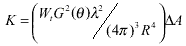
The selected mathematics model equations are respectively the radar imaging equation, the radar equation and the gray equation. The radar imaging equation is:
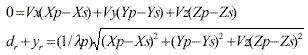
where (Xp, Yp, Zp) and (Xs, Ys, Zs) are the ground coordinates of the ground point P and the side-looking radar's antenna S. (Vx, Vy, Vz) is the speed vector.
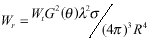
The radar equation for point objects is:
The radar equation for area objects is:
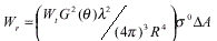
where G(q) is the antenna plus; l is the wavelength; s is the efficacious scattering section; s0 is the average scattering coefficient; Wt is the transmitting power of SAR transmitter; R is the distance between ground objects and antenna; A is the SAR irradiation area.
The radar gray-level equation is:

where g is the transferring function of film; Rn is the Guass normalized stochastic variable; N is
the independent sample number; k is constant; M is the transferring function of the receiver;
4 Image processing and information retrieval
As described earlier, we have explained that the direct goal of computer simulation SAR system is to obtain the SAR image. Next what we need to do is to process the SAR image and then extract information. Image processing is convenient for information extraction, and information extraction is used for extracting the interested information from the SAR image, for instance geological structure, crop yield estimation and etc., and directly severing application. Therefore, the image processing and information retrieval are also the important part in the computer simulation SAR system. Because the simulating model is an ideal model, the system error and stochastic error derived from radar process would not be considered here.
This part of content has been described in many books relating to remote sensing image processing, so it would not be introduced at large here. Presently, the most of functions and methods of image processing and information extraction can be performed well by PCI or ERDAS, which are popular business software package. Of course, it can also develop independent software module serving for special purpose.
5 The framework of computer 3D simulation SAR integrated system
5.1 Basic approach of realizing the simulation SAR integrated system
The basic approaches for realizing the computer 3D simulation SAR system are concluded as follows:
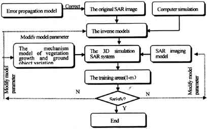
Figure 1 Approach of Realizing The Computer Simulation SAR Integrated System
5.2 Integrated framework for computer 3D simulation SAR system
The integrated system consists of five parts: SAR simulation imaging system; vegetation and ground object simulating system; image processing and information retrieval; application model; 3D language environment. The application for simulation SAR system using computer has been mentioned in Introduction. Besides these applications, it also includes flood prediction, military reconnaissance and battlefield simulation. The 3D language environment is a kind of expression of simulating SAR system, and it can strengthen the visual effect .analyze and embody the work behaves and effects of the 3D simulation SAR system in different conditions from multi-angles. Figure 2 shows the framework of Computer 3D Simulation Integrated System.
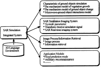
Figure 2 The Framework of Computer 3D Simulation Integrated System
The simulation SAR system has some characteristics as follows:
1) SAR imaging system simulates SAR to transmit and receive wave and form image. Considering the relations among themselves and the error effects, we can establish the signal transmitting equation. Adjusting the imaging parameters and the attitude of aircraft, we can gain different images which can be able to serve for different applications. Of additional interest here is that the imaging system can even provide images with different precision. During designing the real SAR system, due to the design problem or high price of hardware, perhaps we can not obtain high-resolution SAR images. However, only if we get the corresponding algorithm in the simulation SAR system, we can obtain the high-resolution simulation images.
2) Using structure real model, on the one hand it can simulate realistic structure of vegetation and ground objects, on the other hand it can calculate the signal echo through simulating the interaction between microwave and vegetation and ground objects. This simulating system can not only produce the SAR simulation image at the same area and at different time, but also produce the SAR simulation image at different areas and at the same time.
3) Characteristics of radar image produced by the simulating system are as follows:
i.Besides the model error, the simulation images which use ideal algorithm model don't contain these errors derived from outside factor disturbance.
ii.The radar image is not a simple COPY for the simulating ground object or vegetation but the expression of physical mechanism of interesting areas. So we can dig out much more knowledge from the image.
iii. It can be able to be fused with other data sources.
6 Conclusion and prospect
In this paper, we review the research situation of computer simulation and the work mechanism of real SAR system, discuss the integrated framework for computer 3D simulating SAR system, put forward the preliminary conception of integrated system and expound the advantages of 3D simulation using computer. Though some of research works are in the preliminary stage in the whole framework yet, we trust that the 3D simulating SAR system will be able to bring about great change to remote sensing technology.
At the same time, here we should realize definitely that due to the complication, diversity and variation of natural world, it also means that the task of computer simulation SAR system is time-consuming and very hard.
Acknowledgments
This work is supported in part by Chinese Academy of Sciences Project Fund coded KZ95T-03- 04-04.Kjg51-B1-703 and in part by National Natural Science Fund Committee Project coded 69896250-4. The author would like to appreciate Prof. Zhou chenhu.Prof. Xiang yueqian.Dr. Du yunyan and Dr. Chen lijun for their help in the preparation of this manuscript.
References
Remote Sensing.SAR.Computer 3D Simulation Technique.Scattering Characteristics.Imaging Mechanism
Abstract
As a kind of active microwave remote sensing, Synthetic Aperture Radar has become one of main directions of development of remote sensing. Because SAR imaging process overmuch depends on the sensor and the scattering characteristics of ground object, it not only brings us some limitations on obtaining image, but also introduces errors into SAR image during obtaining image process. These problems will be discussed in this paper. We firstly review the computer simulation technique in remote sensing, the scattering characteristics of ground objects and the SAR imaging mechanism. Next, we propose the framework of computer simulation SAR integrated system. This system can produce dynamically SAR images not only in various kinds of incident angle.wavelength and polarimetric ways of sensor, but also in different phases of ground objects.vegetation variation. Using this system, we can replace the field work, save time and expenses, and avoid the risk aroused by wrong decisions and operations.
1 Introduction
The development of remote sensing has come into a new stage in the 1990s this century. As a kind of active microwave remote sensing which is one of important symbols in unprecedented development of remote sensing, Synthetic Aperture Radar has become one of main directions of development of remote sensing. SAR has unique advantages over the optical and infrared sensor, which include high resolution. round-the-clock work and the ability of penetrating through soil and vegetation in certain depth. Presently, SAR has important values in monitoring disaster and environment.resources investigation.ocean research.military scout and survey scopes.
Now the researches for SAR mainly focus on three aspects: 1. Sensor system and the imaging system in the air; 2. The scattering characteristics of ground objects; 3. Postprocession work in the house including image processing and information extraction.
Though SAR imaging has lots of advantages over optical remote sensing, the imaging process overmuch depend on the SAR sensor and the scattering characteristics of ground object So SAR provide us with images which are only confined a certain wavelength.polarimetric ways of sensor.time and special location et al. In additional, due to the limitations of equipment and processing techniques, most of operations performed in the air during the a series of processes from transmitting wave to producing image will inevitably introduced unpredictable system and random error into radar image For example, transfer dissipative.aircraft motion error and operation error will result in the uncertainty of SAR image. These uncertain information bring difficulties to image processing. information extraction and the mechanism research of remote sensing.
Whereas, we propose one kind of computer simulation SAR system which integrates the subsystem of sensor and imaging.the subsystem of scattering characteristics of ground object and the subsystem of information retrieval into one to produce SAR simulation images using computer completely, that is, the three subsystems are implemented only using computer to simulate their work situation in reality.
The direct goal of computer simulation SAR system is to produce real time.dynamic images. These images can be obtained not only in various kinds of incident angle.wavelength and polarimetric ways of sensor , but also in different phases of object.vegetation change. The final goals of this system are as follows: 1. Being capable of grasping the difference of images produced with different parameters(incident angle.wavelength and polarimetric ways ) under complex conditions. This predictability can help the integrated system to choose optimal system parameters(Shu,1997). 2. Being used in remote sensing inversion, finding the law of scattering characteristics of ground objects and establishing the quantitative relationship between scattering characteristics of ground objects and SAR image, ultimately replacing field work completely. 3. Saving time and money, and avoiding the risk and needless expenses produced by wrong decisions and operations. 4. Correcting the real SAR image using the simulation SAR image at the same area. 5. Helping us to know more the detail of system, and know how the critical part to effect the work status of whole system (for example, regulating some system parameter and observing how system to change).
In what follows, we first review the development of computer simulation technique in remote sensing. Next, the computer SAR imaging mechanism is described. Then, the image processing and the information extraction for SAR simulation images are discussed. In Section 5, we propose the basic approach of realizing the computer simulation SAR integrated system, and establish the integrated framework for computer 3D simulation SAR system. The conclusion remarks on computer 3D simulation SAR system are presented in the final section.
2 The Feasibility Analysis of Computer Simulation SAR
In this section, we mainly discuss the basic environment for utilizing the computer simulation SAR and the development status of computer simulation SAR at the present time.
2.1 The Basic Environment
2.1.1 The development of techniques of obtaining Remote Sensing information
In recent years, the Remote Sensing techniques take high-speed development. Various sensors existed include active sensors.passive sensors. aircraft and satellite sensor.optical sensor. infrared sensor and microwave sensor. Especially, high resolution CCD sensor coming out and high resolution commercial satellite blast-off in recent years have provide lots of air-to-ground information, so to speak, nearly arriving “information explosion” (Chen et al, 1998).
2.1.2 Research of Mechanism of Remote Sensing and Information Extraction
Object of remote sensing is the ground object. The essence of the remote sensing is the problem of inversion, that is, reasoning reversedly the geometry and physics characteristics of ground objects through microwave or light wave received (Chen,1998). For using better remote sensing data, many scholars of remote sensing devoted to the research of inversion of remote sensing all the time, and have gained plentiful achievements. Information extraction servers application directly. Presently, the work can be performed well by business software packages.
2.1.3 The Development of Computer 3D Simulation Techniques
Simulation is the modeling of a part of the world that we want to understand. A simulation echoes the behavior of this real world system as it changes from one state to another through time. A computer simulation provides a tool for studying real world systems in order to predict their behavior under a variety of conditions (Simulation Dynamics Inc. 1999). As the computer graphics and calculating functions become powerful gradually, computer 3D simulation techniques with might redoubled have come into the stage of application. For example, military tactics manoeuvre.simulation tornado and medicine expert directing surgery scene ,even some games we often play.
2.2 The Development Status of Computer Simulation SAR
In above section, we have mentioned that remote sensing techniques.computer techniques and simulation techniques have provided with abundant resources for computer 3D simulation SAR system. In this section, we mainly review computer 3D simulation in remote sensing in the world at the present time, which includes the simulation of scattering characteristic of ground objects and the simulation of remote sensing imaging.
2.2.1 The Simulation of Scattering Characteristic of Ground Objects
We have above mentioned that the essence of the remote sensing is to reason reversedly the geometry and physics characteristics of ground objects through microwave or light wave received. BRDF and s0 are attribute values to embody the geometry and physics characteristics of ground objects, nay are the important factors to understand remote sensing and monitor the vegetation canopy change. So it is fundamental and important step to study BRDF and s0.
As computer techniques developing at striking speed, the method using computer simulation to gain BRDF and s0 like a new force suddenly rise has a good prospect. This method is not only instead of lots of field experiments in certain degree, but also a tool to identify other simple.practical model. Next, we introduce the research status of computer simulation at the scattering characteristic of ground objects.
2.2.2 Methods of Computer Simulation in Remote Sensing
Computer simulation was applied long before in calculating atmosphere radiative transfer function and determining the point distributed function of ground reflecting through atmosphere. When RT function was introduced into the research of vegetation reflect, Monte Carlo was introduced naturally into the scope at the same time (Li, 1995).
We found the irrationality of RT function using computer simulation in vegetation reflection soon, so the computer simulation developed to structure real model simulation making use of strong graphics function of computer. Structure real model includes two parts: one is to simulate realistic structure of ground objects, the other is to simulate the interaction between microwave and ground objects
Presently, there are four methods to simulate realistic structure of ground objects: (1)fractal method(Asrar, et al, 1991); (2) methods based on special graphics software warp. For example, DIANA model based on computer graphics (Goel et al, 1991,1999; Qin, et al 1995, 1999). In additional, “Rayshade” graphics software package (Borel, C et al, 1991,1999); (3) Method based on the vegetation growth model (Dauzat, et al, 1991); (4) Method based on photogrammetry and the vegetation growth mechanism model (Barnsley, et al,1991).
2.2.3 Application Status
Structure real model can almost mix the false with the genuine. When Prof. Goel showed crop land and orchard made by his DIANA model using videotape, audience thought it be a videotape of real scene. When using Monte Carlo method acting on fractal tree to gain s0, Prof. Sarabandi and Lin in Michigan University also have obtained good effects (Lin Y., 1999).
Both Institute of Remote Sensing Application of Chinese Academy of Sciences and Institute of Remote Sensing in Peking University have acquired some results in these aspects. So we can say that computer simulation at the scattering characteristic of ground objects has established good basement for utilizing computer 3D simulation SAR system.
2.3 SAR Image Simulation
Firstly, we explain the process of radar image simulation: the simulation of radar image is a technique which is based upon the ground real situation.map or remote sensing materials or the existed radar image according to the imaging mechanism of radar image to produce different frequency.wavelength.polarimetric ways radar images which are applied to various occasion.
The selected physical model used in radar image simulation is point scattering model. The selected mathematics models are respectively the radar imaging equation, the radar equation and the gray equation. These functions will be presented in section 3.
The data sources for SAR simulation image include radar system parameter.database of geography information and database of ground scattering characteristic. The database of geography information includes DEM and database of land use. The database of ground scattering characteristic includes diversified ground objects scattering characteristics at different time and different radar parameters, that is, s or s0.
When radar imaging, the ground is divided into grid cells according to the size of resolution cell. Each cell of image pixel is corresponding to each ground cell. Based on the imaging mechanism of radar image and scattering characteristic of ground objects, we make use of the radar equation and the gray equation to calculate the gray value of ground object of each cell according to point scattering model, and then form radar image. For gaining a better radar image, we should consider the geometry characteristics of radar image, for examples, foreshortening and layover and etc(Shu,1997).
Though radar image simulation is of embryonic form of computer simulation SAR system which this paper proposed, it is only static process based on two databases existed, and can’t realize transmitting and receiving analog signals in real-time.dynamic way. A great gap has existed between its function and the final goal of computer 3Dsimulation integrated system we have proposed in the introduction.
3 Simulation of SAR system imaging mechanism
If we simulate the work status of real SAR sensor using computer, we should firstly analyze on the characteristics and imaging mechanism of real SAR system, and on the basis of this we can set up the signal transferring model of SAR imaging simulation system.
3.1 Principle of real SAR system
The principle of Synthetic Aperture Radar can be explained from the three viewpoints of synthetic aperture, frequency analysis and microwave holography. In this paper, we mainly adopt the view of synthetic aperture to explain it (Lou, 1997). It can be generalized as follows: through this method of the phase compensation of the signals received by the same antenna at different times and at different positions, we could form the equivalent large antenna array for the ground objects with radar going forward. The signals for the same object received by the antenna of synthetic aperture do not obtain at the same time, which need to record the amplitude and phase of a signal echo at each position. Because the distance between the aerocraft and ground objects is different, the phase and intensity of each signal is also different. So, a coherent image can be obtained in this way, which could be reverted to the practical image of ground objects only if after processed. In the real SAR system, the emphasis is to research on the radar imaging system. It is also the main part of our research work.
3.2 Imaging mechanism model for SAR simulation system
The physical model that is used for simulating radar image is the point scatter model:
where
s(R,x)=1,
The functions h1(R,x) and h2(R,x) are respectively the range impulse response function and the azimuth impulse response function.
The selected mathematics model equations are respectively the radar imaging equation, the radar equation and the gray equation. The radar imaging equation is:
where (Xp, Yp, Zp) and (Xs, Ys, Zs) are the ground coordinates of the ground point P and the side-looking radar's antenna S. (Vx, Vy, Vz) is the speed vector.
The radar equation for point objects is:
The radar equation for area objects is:
where G(q) is the antenna plus; l is the wavelength; s is the efficacious scattering section; s0 is the average scattering coefficient; Wt is the transmitting power of SAR transmitter; R is the distance between ground objects and antenna; A is the SAR irradiation area.
The radar gray-level equation is:
where g is the transferring function of film; Rn is the Guass normalized stochastic variable; N is
the independent sample number; k is constant; M is the transferring function of the receiver;
4 Image processing and information retrieval
As described earlier, we have explained that the direct goal of computer simulation SAR system is to obtain the SAR image. Next what we need to do is to process the SAR image and then extract information. Image processing is convenient for information extraction, and information extraction is used for extracting the interested information from the SAR image, for instance geological structure, crop yield estimation and etc., and directly severing application. Therefore, the image processing and information retrieval are also the important part in the computer simulation SAR system. Because the simulating model is an ideal model, the system error and stochastic error derived from radar process would not be considered here.
This part of content has been described in many books relating to remote sensing image processing, so it would not be introduced at large here. Presently, the most of functions and methods of image processing and information extraction can be performed well by PCI or ERDAS, which are popular business software package. Of course, it can also develop independent software module serving for special purpose.
5 The framework of computer 3D simulation SAR integrated system
5.1 Basic approach of realizing the simulation SAR integrated system
The basic approaches for realizing the computer 3D simulation SAR system are concluded as follows:
- Establishing the error propagation model. In this paper, it is
mentioned in section 2 that computer can be used to simulate the ground
objects and directly make inversion. But due to the complexity and
variety of ground objects, this method need further research yet. At the
present time, the usual method of inversion is based upon the images of
remote sensing.
As we know that owing to the limitation of equipment and processing technology, the error of SAR image obtained is relatively great, which bring many difficulties to research on the remote sensing mechanism. So, for gaining the right inversion parameters, the first step should lay on researching on the error propagation model of SAR image from the mechanism of SAR setting out, analyzing on various errors sources effecting real SAR image. We use these sources to correct the corrupted radar image. Based on the correct image, the further research should be performed on the relationship between the gray value of radar image and the scattering characteristic of ground objects. So to establish error propagation model is a rudimental work for realizing the computer simulation SAR integrated system. - Establishing the inverse model for ground objects. On the basis of large amount of the correct remote sensing images and the scattering mechanism of ground objects in various conditions obtained through field work or computer simulation method as an assistant tool (in section 2), the inverse model can be set up.
- Establishing the mechanism model describing vegetation growth and ground object variation.
- Establishing the SAR imaging model. It is difficult to simulate and set up signal propagation model to form coherent image under sensor flight status.
- Setting up the 3D simulation SAR system. This simulation SAR system will integrate these models mentioned above into one, and meanwhile harmonize the relationship among them.
- Model training. We select M training areas and simulate them using the 3Dsimulation system by means of the material of training areas (DEM or land use map which mainly provide with the rough distribution information of landform or vegetation). The simplest method to test model fidelity is to examine by eyes (Lin, 1999). At the same time, it can combine with field experiment and high-resolution images to adjust the simulation models until the error between the simulation image and the theoretic images is satisfying. When the train is finished, we can use the 3D model of SAR system for producing SAR simulation image. Figure 1 shows the flow chart of realizing the 3D computer simulation SAR system.
Figure 1 Approach of Realizing The Computer Simulation SAR Integrated System
5.2 Integrated framework for computer 3D simulation SAR system
The integrated system consists of five parts: SAR simulation imaging system; vegetation and ground object simulating system; image processing and information retrieval; application model; 3D language environment. The application for simulation SAR system using computer has been mentioned in Introduction. Besides these applications, it also includes flood prediction, military reconnaissance and battlefield simulation. The 3D language environment is a kind of expression of simulating SAR system, and it can strengthen the visual effect .analyze and embody the work behaves and effects of the 3D simulation SAR system in different conditions from multi-angles. Figure 2 shows the framework of Computer 3D Simulation Integrated System.
Figure 2 The Framework of Computer 3D Simulation Integrated System
The simulation SAR system has some characteristics as follows:
1) SAR imaging system simulates SAR to transmit and receive wave and form image. Considering the relations among themselves and the error effects, we can establish the signal transmitting equation. Adjusting the imaging parameters and the attitude of aircraft, we can gain different images which can be able to serve for different applications. Of additional interest here is that the imaging system can even provide images with different precision. During designing the real SAR system, due to the design problem or high price of hardware, perhaps we can not obtain high-resolution SAR images. However, only if we get the corresponding algorithm in the simulation SAR system, we can obtain the high-resolution simulation images.
2) Using structure real model, on the one hand it can simulate realistic structure of vegetation and ground objects, on the other hand it can calculate the signal echo through simulating the interaction between microwave and vegetation and ground objects. This simulating system can not only produce the SAR simulation image at the same area and at different time, but also produce the SAR simulation image at different areas and at the same time.
3) Characteristics of radar image produced by the simulating system are as follows:
i.Besides the model error, the simulation images which use ideal algorithm model don't contain these errors derived from outside factor disturbance.
ii.The radar image is not a simple COPY for the simulating ground object or vegetation but the expression of physical mechanism of interesting areas. So we can dig out much more knowledge from the image.
iii. It can be able to be fused with other data sources.
6 Conclusion and prospect
In this paper, we review the research situation of computer simulation and the work mechanism of real SAR system, discuss the integrated framework for computer 3D simulating SAR system, put forward the preliminary conception of integrated system and expound the advantages of 3D simulation using computer. Though some of research works are in the preliminary stage in the whole framework yet, we trust that the 3D simulating SAR system will be able to bring about great change to remote sensing technology.
At the same time, here we should realize definitely that due to the complication, diversity and variation of natural world, it also means that the task of computer simulation SAR system is time-consuming and very hard.
Acknowledgments
This work is supported in part by Chinese Academy of Sciences Project Fund coded KZ95T-03- 04-04.Kjg51-B1-703 and in part by National Natural Science Fund Committee Project coded 69896250-4. The author would like to appreciate Prof. Zhou chenhu.Prof. Xiang yueqian.Dr. Du yunyan and Dr. Chen lijun for their help in the preparation of this manuscript.
References
- Chen, S., Tong, Q., Guo, H., The research of remote sensing information mechanism, Science Pr.,.1998
- Shu, N., The principle of radar remote sensing, China: Pub. House of Surveying and Mapping, 1997
- Zhang, C., Synthetic aperture radar: Principles, system analyses, applications, China: Science Pr., 1989
- Xie, S. Et al., Microwave remote sensing technique and application, China: Electron and Industry Pr., 1987
- Guo, H., Xu, G., The research of satellite radar application, Chinese technology Pr., 1996
- Lou, X., Research on Synthetic Aperture Radar Imaging, Calibration and Image processing, Master thesis in graduate institute of Chinese science and technology University.1997.
- Li, X., Wang, J., Vegetation optical RS model and vegetation structure parameter.China: Science Pr., 1995
- Asrar, G., et al, A 3-D RT method for optical remote sensing of vegetation land surface, Proceeding 5 th Intern. Colloq. Physical measurement and signature in remote sensing, Courchevel, France, pp361-367, 1991.
- Barnsley,M.j. et al, 1991,Measurement, Simulation and Analysis of the Directional Reflectance Properities of Earth Surface Materials, Proc.5 Th Intern. Colloq. PMSRS,Courchevel,France,pp.375-382.
- Borel, C. C., Gerstel, S. A. W., and Powers, B. J., 1991, The radiosity methods in optical remote sensing of structured 3-D surface, Remote Sensing of Environment. Vol 36:13-44.
- Borel, C., W. Qin, et al., Recent advances in radiosity 3- D scene modeling and its applications, Remote Sensing of Reviews. , May 1999.
- Dauzat, et al, 1991, Simulation des Transfers Radiatifs sur Marquettes Informatiques de Couverts Vegetaux, Proc.5 Th Intern. Colloq. PMSRS,Courchevel, France, pp.415-418.
- Goel, N. S. and W. Qin(1994) Influences of canopy architecture on relationships between various vegetation indices and LAI and FPAR: a computer simulation: Remote Sensing of Reviews, 10:309-347.
- Goel, N. S. and Rozehnal, I., 1992, An architecturally realistic model for radiation regime in vegetation canopies, Proceeding of IGARSS'92,1:48-50.
- Goel, N. S. and Rozehnal, I., 1991, A computer graphics based model for scattering from objects of arbitrary shapes in the optical region, Remote Sensing of Environment, Vol 36:73-104.
- Lunetta, R. S et al(1991)., Remote sensing and geographic information system data integration: error sources and research issues, Photogrammetric Engineering & Remote Sensing, Vol 57, No. 6, pp.677-687.
- Lin Y., and Sarabandi K(1999), A Monte Carlo coherent scattering model for forest canopies using fractal-generated trees, IEE Transaction on Geoscience and Remote Sensing, Vol 37, No. 1, January 1999.
- Qin, W., and N. S. Goel(1995), An evaluation of hotspot models for vegetation canopies, Remote Sensing of Reviews. , December:121-159.
- Qin, W. et al., 1-D canopy radiative transfer modeling: recent progress and research priorities, Remote Sensing of Reviews. , May 1999.
- Qin, W. et al., A review on hot spot research and applications, Remote Sensing of Review. , May 1999.
- Qin W., S. A.W. Gerstl, 3-D scene modeling of Jornada semi-desert vegetation cover and its radiation regime, Remote Sensing of environment, 1999.
- Simulation Dynamics Inc. 1999, Webs i t e: http://www.simulationdynamics.com/Page3.ht ml