| GISdevelopment.net ---> AARS ---> ACRS 1999 ---> Poster Session 3 |
An Impact Analysis of
Shifting Cultivation in the Forest of Northern Laos using GIS and
Satellite image
Myung-Hee Jo
Assistant Professor,Dept., of Geodetic Engineering, Kyungil University,
Tel:(82)-53-850-7312, Fax:(82)-53-854-1272
E-Mail:mhjo@bear.kyungil.ac.kr
Takaaki Niren
Professor, Dept., of Environmental Planning, University of Shiga Prefecture,
Hikone, Japan
Tel:(81)-749-28-8278, Fax:(81)-749-28-8348,
E-mail:niren@ses.usp.ac.jp
Keywords: Shifting Cultivation, Laos, Impact Analysis, GIS, Remote Sensing
Abstract
MOS-1 satellite image and 40 points of soil samples are analyzed to identify the distribution of shifting cultivation and GIS technique was applied to evaluate the environmental problems for Nam Khane watershed. The land use classification map was prepared and the values of each land use area by elevation level and soil property were produced respectively.
Excessive agricultural activity of shifting cultivation in the Nam Khane watershed not only decreased the forest area, but also changed the primary forest into secondary woodland of shrub. On the phase of soil property, it accelerated the soil and gully erosion, and acidification. To solve these environmental problems, the most import step is to settle the agriculture from shifting cultivation to permanent cropping.
1. Introduction
The Nam Khan River runs about 90km along the westward of northern mountain area of Laos and joins the Mekong River near Luang Prabang, the second largest city in Laos. The wide area of shifting cultivation in Nam Khan watershed has been causing the destruction of forest and soil.
The seriousness of food shortage and environmental problem of this area led to the research team for the watershed management of this area by UNCRD (United Nations Center for Regional Development) from April, 1992. And the author was a number of it covering the natural environments and image analysis of satellite images. The research lasted through February, 1994, and topographic map(1/50,000), aerial photos, satellite image, geological map of that area have been analyzed. Its soil, topography, vegetation, agricultural method have studied through four times of ground survey, and interview survey among the villagers was carried out.
This study is summing up of 1 topographic characteristics 2 shifting cultivation 3 environmental problems concerned with shifting cultivation of H.Khane watershed which was most typically and widely analyzed among Nam Khan watershed.
2. Topographic Characteristics
The mainstream of the Nam Khane flows incised meander widely but that of H.Khane, one of its tributary flows almost straight under the influence of northeastern– southwestern lineament. The topography of H.Khane such as elevation, slope, property of geologic bed rock is divided into 4 topographic units as follow.
1. Highland (plateau):
ground of pure limestone with 800-1500m of sea level and land surface with more or less than 10% of surface slope, karst landform has been developed on the surface with many enclosed hollow such as doline, uvala, etc. There seems to be no surface water because almost all water on the ground flows deep underground through sink-hole.
2. Steep slope:
developed surrounding plateau, a lot of part of which is 60% slope of outcrop rock and is found at more less than 700-1200m of sea level. Its geology from the bottom of this to the surface of plateau is pure limestone and the water flowed underground from the surface of the plateau through sink-hole forms karst spring everywhere near the end part of this. The Karst spring is the start point of first order stream and generally village is settled around the karst spring.
3. Hill-side piedmont:
piedmont eroded by first order stream with more or less than 12% of surface slope and distributed under steep slope. Its sea level is from 800m at right part of the Nam Khane, 600m at the left part northwestern, to 300m roughly of the lowest figure. The geology here with Pz2 and cPz2 do not contain CaCO3 enough to form karst landform and enclosed hollow such as doline is not worth considering. Shifting cultivation is well developed.
4. Alluvial plains:
narrowly distributed where the Nam Khane and the H.Khane gets together with floodplains of present stream and river terrace. The average degree of slope is more or less than 3%
3. Forest Damage with Shifting Cultivation Area
3.1. Practical Situation
Shifting cultivation is an agricultural method in which the seed is put in the holes on the surface after cutting down and burning the trees during the dry season for one to two years and moved to another place because of productivity decrease.
Shifting cultivation is popular in the mountain area of northern Laos with a little alluvial plain but many piedmont hills with gentle slope. Consequently about no more than 10% of primary forest remains intact and 1/4 of the rest is now being cultivated and shrubs, bamboos deserted after shifting cultivation. Four parcels of land are cultivated in turn because cultivation farming is started again after burning three-year-old fallow.
The chief industry in this area is agriculture and 85% of paddy yield is upland rice cultivated in shifting cultivation area and 15% of it is paddy cultivated in alluvial plain. Therefore shifting cultivation plays a chief part in the economy of this area.
There are about a little more than 70 ethnic groups are distributed and the three main tribes are Lao Sung in high lands, Lao Theung in the middle of the mountain, and Lao Leum in low lands. The exact number is 7745(1992.12) which consists of 13% of Lao Sung, 59% of Lao Theung, and 28% of Lao Leum. Lao Sung is populated on plateau and cultivates opium with the advantages of shifting cultivation, cool climate and isolation from political power. Lao Theung are widely populated and their chief farming is shifting cultivation and Lao Leum in low land and dominate Laos in politics and economy.
3.2. Satellite Image Processing
Shifting cultivation has been causing serious environmental problems in the area but it has not been estimated at all how much area has been destroyed and which part is in the most serious condition by the government. Besides annual shifting makes the statistic survey more difficult. In order to figure out the distribution of shifting cultivation area, land cover classification was performed using satellite images.
The satellite image used is MOS-1 MESSR and its pixel size is 50m. Performing geometric correction according to UTM using ERDAS and making false color composite after cover RGB filter on 4/2/1 band produced (Photo 1).
The red part in the photo shows present primary forest, which is partly distributed on plateau and steep slopes. The light red part is fallow, which includes the secondary forest of shrubs, bamboo of fallow after shifting cultivation. The blue part is present shifting cultivation area and the green part of plateau is the opium cultivation area. The long and narrow white part along to the Nam.Khane is paddy field of alluvial plain.
But classification of images was performed because the borderlines between classes are not clear and the accurate data are not available with false color composite. The area was classified into 6 classes of shifting cultivation area, opium, fallow, forest, water, paddy field through aerial photos and ground survey. The result of supervised classification selected about 2-9 training areas each class through maximum likelihood classifier method is as (Photo 2). As is shown in (Photo 2), opium is chiefly distributed on plateau, shifting cultivation is on piedmont, and paddy field narrowly along the Nam.Khane.
The size of the areas according to the class/elevation are calculated by overlaying the thematic maps of each elevation on this chroplethe map using Arc/Info GIS Software.
On the whole fallow occupies the largest area of 47.1% and forest occupies 20.9%, or about 1/5 of the whole area. Shifting cultivation area, which is more or less than 13%, is almost as large as opium cultivation area and paddy field occupies only 4%. Shifting cultivation area is chiefly distributed at the elevation of 400-800meter and so is fallow which is deserted after shifting cultivation.
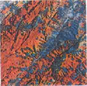
Photo 1. False color composite of H.Khane basin with MOS-1 image
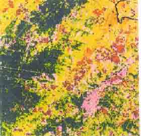
Photo 2. Land use classification map of H.Khane basin
Table 1 Soil content analysis of H.Khane basin
| Grain Size | PH | OM | C/N | Nitrogen | ||||||
| Sand | Silt | Clay | HO | KCI | Total | N-NH3 | N-NO3 | |||
| Paddy Field Upland Rice Mixed Forest Vientiane Plain |
(%) | (%) | (%) | (%) | (%) | (%) | (%) | |||
| 33.85 | 36.71 | 26.49 | 7.49 | 6.98 | 2.35 | 8.06 | 0.170 | 24.13 | 12.04 | |
| 25.03 | 41.11 | 33.87 | 5.62 | 4.95 | 2.91 | 7.33 | 0.219 | 23.92 | 9.80 | |
| 32.53 | 39.28 | 28.16 | 6.35 | 5.89 | 3.08 | 7.92 | 0.222 | 27.35 | 12.12 | |
| 62.40 | 25.90 | 11.70 | 6.30 | 5.50 | 0.57 | 15.0 | 0.022 | 14.00 | 7.00 | |
| Phosphorous | Potassium | EC | CaCO3 | Exchangeable (mg/100g of soil) | CEC-S | Fe2O3 | |||||
| P | P2O5 | KO | KO | Ca++ | Mg++ | K+ | Na+ | ||||
| (mg) 1.10 1.005 1.25 8.02 |
(%) 0.035 0.037 0.039 0.012 |
(%) 0.90 0.90 0.86 0.09 |
(%) 8.19 15.21 19.05 28.0 |
150.59 53.33 100.41 |
42.60 0.17 0.23 |
21.52 4.51 11.54 1.47 |
1.62 2.03 2.53 0.55 |
0.20 0.40 0.40 0.06 |
0.28 0.20 0.22 0.12 |
23.50 9.10 14.68 2.20 |
0.025 0.017 0.023 |
4. Environmental Problems by Shifting Cultivation
4.1 Forest Degradation
excessive agricultural activity of shifting cultivation bit into the forest, changed into primary forest of trees into the secondary woodland of shrubs and bamboo and decreased of the secondary forest. These problems are because shifting cultivation could cause more serious flood and serious soil erosion.
4.2 Soil Degradation
When the slopes covered with thick rain forests become bare from shifting cultivation, the soil becomes barren from the erosion by rain wash and the topography is destroyed from erosion by gully. As drainage network analysis reveals, the bifurcation of the first order stream is over 6 value so that gullies are being accelerated recently.
To find out the features of the soil of this area, 15, 12, 13 soil sample from paddy field, upland rice, and mixed forest were analyzed by Vientaine Soil Survey of Laos. The analysis of the grain size, pH, chemical content of each place is shown on Table <1>. The result of Vientaine plain, which had been made before, was presented here to be compared with the soil of the study area.
The result can be summed up as follows.
(1) The acidity of shifting cultivation is much higher than that of paddy field and mixed forest area. That is because much base was lost from shifting cultivation.
(2) Quite a little CaCO3 is accumulated in the shifting cultivation area and mixed forest area as much as 42.6% of CaCO3 is accumulated in alluvial paddy field. Amount of CaCO3 from the slope is small because of leaching, however, in the alluvial plain, the amount of it is too much which accumulated from slope and causes low productivity.
(3) The lowest CEC of shifting cultivation area shows poor condition of the soil degraded soil.
To sum up the problem of degraded soil, the soil in the slope was eroded into barren acid soil while the topography was changed into bad land by gully erosion. Meanwhile, paddy field become less productive with excessive accumulation of CaCO3 from the slopes, elevated the river bed causes frequent flood and inundation and dirty water brings about sanitary problem of water quality.
5. Conclusion
Nam Khane watershed, in the Northern Laos, consist of limestone plateau surrounded with steep slope (above 1000m), wide piedmont hill land(300- 700m) and narrow alluvial plain. Opium on the plateau and up-land rice on the hill-side are cultivated for each, but its shifting activity, which degrades the forest and soil, has caused the serious environmental problems.
MOS-1 satellite image and 40 points of soil samples are analyzed to identify the distribution of shifting cultivation and to evaluate the environmental problems for Nam Khane watershed. The land use classification map is presented on the photo 2, and the value of each land use area by elevation level and soil property are showed on the table<1>.
Excessive agricultural activity of shifting cultivation in the Nam Khane watershed not only decreased the forest area, but also changed the primary forest into secondary woodland of shrub. On the phase of soil property, it accelerated the soil and gully erosion, and acidification. To solve these environmental problems, the most import step is to settle the agriculture from shifting cultivation to permanent cropping.
Reference
- Collins N.M., J.A Sayer and T.C. Whitmore, 1990, The Conservation Atlas of Tropical Forests Asia and The Pacific - 20 Laos, pp. 166-173.
- Evenson,J.P.1993. " Slash- and - Burn Agriculture : the Continuing Dilemma ",Report of the Nabong Technical Meeting on Shifting Cultivation Systems and Rural Development in the Lao PDR, pp.22-32.
- Fujisaka, S.,1991. " A Diagnostic Survey of Shifting Cultivation in Northern Laos: Targeting Research to Improve Sustainability and Productivity", Agroforestry Systems, Vol. 13, pp. 95-109.
- Laurent Chazee,1993. " Shifting Cultivation Practices in Laos : Present Systems and Their Future ", Report of the Nabong Technical Meeting on Shifting Cultivation Systems and Rural Development in the Lao PDR, pp.66-97.
- Martin Stuart-Fox, 1986. Laos: Politics, Economics and Society, Frances Printer Publishers, London, 220P.
- Myung-Hee JO,1994. " An Analysis of Shifting Cultivation Areas in Luang Prabang Province, Lao PDR, Using Satellite Imagery and Geographic Information Systems ", Journal of the Korean Society of Remote Sensing,10(1), pp.43-53.
- Myung-Hee Jo, 1993. "Preparation Of Thematic Maps for Nam Khane Watershed Management in Luang Prabang Province, Lao PDR, Using Remote Sensing and Geographic Information Systems, Geographical Review, Kyung Pook Nationaluniv., Vol. 12-13 pp. 101-108.
- Myung-Hee Jo, 1995. "A Study on Opium Field Detection of the Golden Triangle in the Indochina Using MOS-1 Satellite Image", Research Review of the Kyungpook Sanup