| GISdevelopment.net ---> AARS ---> ACRS 1999 ---> Poster Session 3 |
Threshold Operation for
Extraction of Mangrove Forest with TM Data of Landsat 5
Kazuhiro
SATO
College of Agriculture, University of the Ryukyus,
Senbaru 1, Nishihara, Okinawa 903-0213, Japan
Tel.81-98-895-8792, Fax. 81-98-895-8734
E-Mail:sato4408@agr.u-ryukyu.ac.jp
Minoru NAKAJIMA
Omodaka Electronics Co. Ltd., 101 Column Otsuka,
Otsuka 4-43-9, Bunkyou-ku, Tokyo 112-0012, Japan
Tel.81-3-3944-8661,Fax.81-3-3944-8972
E-mail: omdec@mub.biglobe.ne.jp
Takashi HOSHI
Faculty of Engineering, Ibaraki University,
Nakanarisawa 4-12-1, Hitachi, Ibaraki 316-8511, Japan
Tel.81-294-38-5133, Fax.81-294-37-2223
E-mail:hoshi@cis.ibaraki.ac.jp
Keywords:Thresholds, Automatic selection,
Mangrove area, TM data of Landsat
Abstract
We had suggested a mask process that separates three categories of land area, mangrove forest and waters from a mangrove area composed with the categories. And the procedure and a practical way had been examined to decide threshold in order to avoid the misclassification and to prepare data sets for quantitative estimation of stand parameters on mangrove forest with TM data of Landsat 5. In this paper, an automatic determination method of the threshold was examined to produce masks for extraction of individual categories. In the first step, on the histogram of CCT count for band 4 and 5, the provisional range of threshold selection was decided and the pixels corresponded to each CCT count values in the rage were displayed with white on a black background. After the locational distribution of those pixels was observed and the meaning of pixel distribution was checked, the ranges for searching threshold were decided.
In the second step, the Otsu’s automatic threshold selection method was applied to the ranges as an automatic searching threshold and the validity of the results was verified.
1. Introduction
One of the authors and other researchers had shown it is possible to estimate stand parameters on mangrove forest such as mean of tree height, diameter at breast height, trunk volume and so on, with TM data of Landsat 5 and several indexes expressed combination of the data (Dwi et al., 1997). It must be prepared a data set on mangrove forest without surroundings for application of the estimation equations. On the other hand, although many and good training areas are selected, misclassification occurs to some extent in case of classification of mangrove area by any classifiers. Because there are pixels having similar spectral reflectance in the categorized area as land area, mangrove forest and waters. Small ponds, swamps and channels in land area can be classified as a category of mangrove forest or waters, and cutovers and new planted areas on the high level sedimentary areas in mangrove forest can be classified as land area. Although the result was statistically classified by rational classifier, it should include misclassification to some extent in several categories set to put in our circumstances and convenience. A mask procedure was suggested to classify three categories of land area, mangrove forest and waters separately. It is possible to avoid the interference from other quite different category by the classification after the mask procedure as a pre-processing. Three classification imageries can be overlaid (Sato et al., 1997,1998). It was tried to express simultaneously qualitative and quantitative information for example mangrove species and stand stock (Kanetomi et al., 1998).
In this paper, a selection method of threshold for binary value imagery had been examined to build up a stand analysis system on mangrove forest. The selection method was composed of two steps. In the first step, the provisional range including threshold was searched on the histograms of CCT count for band 4 and 5, and in the second step threshold was automatically searched with applying Otsu’s method to slightly wide range selected in the first step.
2. The way of thinking and Method
A histogram of CCT count for band 4 and 5 is synthesized three histograms of three categories of land area, mangrove forest and waters to compose mangrove area. Generally it has three peaks but there is often a case with not clear on them. The degree of clear of the peaks based on the proportion of the sum total each category area, and the existence of land-cover to have similar spectral reflectance with other category such as shallow or muddy waters, ponds or swamps in land area, cutovers or new planted areas in mangrove forest and so on. There may be some a scene without one category. We used band 4 and 5 of TM data of Landsat 5 acquired on 25 April 1990. It covered Mandh area distributed mangrove in the mouth of Inderagiri River, Sumatera. The histograms of CCT count were shown in the left side of Figure 1.
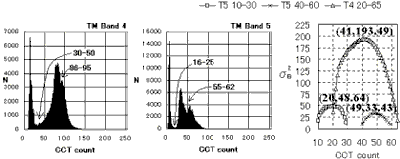
Figure 1. Histograms for band 4 and 5 and provisional ranges to search threshold (left side), sB2 of calculated results with Otsu’ method and the maximum (right side)
Many methods had been suggested for automatic threshold selection in the field of processing to binary value imagery (Kittler et al., 1986, Ots, 1980, Weszka et al., 1974). In case of simple histogram of CCT count and to expect enhancive effect, it was reported that several methods were effective. But these can not be simply applied in case to expect high suitability to the categories set to put circumstances and convenient for us. We tried a way that threshold was determined through two steps. The first step was a process to find provisional rage including threshold on the histogram of CCT count, and the second step was to determine the threshold by application of fit automatic threshold selection to slightly wide range than the provisional range. On the histogram of CCT count for band 4 and 5, waters forms shape peak in the lowest range because waters have lower reflectance than other any categories and the range is very narrow. The next large and wide base peak composed most pixels of land area and mangrove forest for band 4. In case of land area and mangrove forest covered with similar component forest on size, the categories form one peak. In case of land area covered poor vegetation, the category of land area occupies left side of the peak, and in opposite case the category of mangrove forest occupies the side. In these case small valley may be formed halfway up or down the peak, but most pixels occupies overlapped part. For band 5, mangrove forest occupies left side and land area does right side because this band is sensitive to water content. Between two categories relatively deep valley is formed because water content of two are quite different. The matters pointed out above are keys to find threshold between two categories. The provisional rage was determined to search threshold and pixels corresponded CCT count values in the range were displayed with white on a black background for each band.
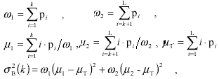
For slightly wide range than the provisional range, Otsu’s method of one automatic selection method was applied to search threshold. Although the detailed description was omitted, the calculation was as follows. L is the width of the range. N is total number of pixel in the range and i n is total number of pixel having CCT count value of i .
then, it is required threshold of k which maximizes sB2.
3. Results, Discussion and Conclusion
Provisional ranges to include threshold were shown in left side of Figure 1. The pixels included in the range were displayed with white on black background for band 4 in Figure 2 and band 5 in Figure 3. The validity of the range was judged through observation of distribution and range of white pixels in the imagery. The range from 86 to 95 for band 4 was judged not suitable to search threshold between land area and other two categories because white parts were covered with similar amount of bio-mass. The range from 16 to 25 for band 5 was better than it from 30 to 50 for band 4. It was considered that muddy waters related with the reason.
In the second step, for the range was judged near to threshold, slightly wide range decided as the range applied Otsu’s method. Calculated sB2 were shown in right side of Figure 1. The value of CCT count maximized sB2 was determined as threshold. The binary value imageries by the threshold were shown in Figure 4. Although tree binary value imageries were displayed, many opposite spots were remained in white and black parts. Remained isolated spots were changed to surrounding as a kind of correction. It was reasonable, for instance the spots in mangrove forest must be classified cutovers or new planted areas in mangrove forest and the spots in land area as ponds or swamps. Corrected two masks produced the method examined here and a mask for mangrove forest made from two masks were shown in Figure 4. It became possible to avoid misclassification with interference from other categories and to prepare data sets for estimation of stand parameters on mangrove forest. The examination on the better method was remained on the suitability of automatic threshold selection methods against the histogram of band 4 and 5 on mangrove area.
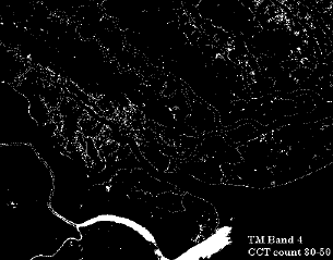
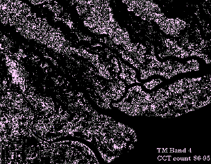
Figure 2. Pixels with white in the provisional range from 30 to 50 and from 86 to 95
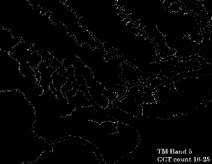
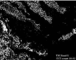
Figure 3. Pixels with white in the provisional range from 16 to 25 and from 55 to 62
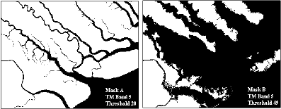
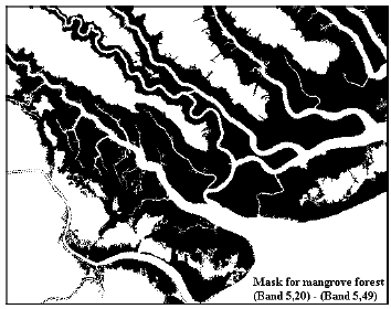
Figure 4. Corrected mask A and B by the threshold determined automatically in the second step and a mask for mangrove forest as reversed imagery of ( A – B )
References
Abstract
We had suggested a mask process that separates three categories of land area, mangrove forest and waters from a mangrove area composed with the categories. And the procedure and a practical way had been examined to decide threshold in order to avoid the misclassification and to prepare data sets for quantitative estimation of stand parameters on mangrove forest with TM data of Landsat 5. In this paper, an automatic determination method of the threshold was examined to produce masks for extraction of individual categories. In the first step, on the histogram of CCT count for band 4 and 5, the provisional range of threshold selection was decided and the pixels corresponded to each CCT count values in the rage were displayed with white on a black background. After the locational distribution of those pixels was observed and the meaning of pixel distribution was checked, the ranges for searching threshold were decided.
In the second step, the Otsu’s automatic threshold selection method was applied to the ranges as an automatic searching threshold and the validity of the results was verified.
1. Introduction
One of the authors and other researchers had shown it is possible to estimate stand parameters on mangrove forest such as mean of tree height, diameter at breast height, trunk volume and so on, with TM data of Landsat 5 and several indexes expressed combination of the data (Dwi et al., 1997). It must be prepared a data set on mangrove forest without surroundings for application of the estimation equations. On the other hand, although many and good training areas are selected, misclassification occurs to some extent in case of classification of mangrove area by any classifiers. Because there are pixels having similar spectral reflectance in the categorized area as land area, mangrove forest and waters. Small ponds, swamps and channels in land area can be classified as a category of mangrove forest or waters, and cutovers and new planted areas on the high level sedimentary areas in mangrove forest can be classified as land area. Although the result was statistically classified by rational classifier, it should include misclassification to some extent in several categories set to put in our circumstances and convenience. A mask procedure was suggested to classify three categories of land area, mangrove forest and waters separately. It is possible to avoid the interference from other quite different category by the classification after the mask procedure as a pre-processing. Three classification imageries can be overlaid (Sato et al., 1997,1998). It was tried to express simultaneously qualitative and quantitative information for example mangrove species and stand stock (Kanetomi et al., 1998).
In this paper, a selection method of threshold for binary value imagery had been examined to build up a stand analysis system on mangrove forest. The selection method was composed of two steps. In the first step, the provisional range including threshold was searched on the histograms of CCT count for band 4 and 5, and in the second step threshold was automatically searched with applying Otsu’s method to slightly wide range selected in the first step.
2. The way of thinking and Method
A histogram of CCT count for band 4 and 5 is synthesized three histograms of three categories of land area, mangrove forest and waters to compose mangrove area. Generally it has three peaks but there is often a case with not clear on them. The degree of clear of the peaks based on the proportion of the sum total each category area, and the existence of land-cover to have similar spectral reflectance with other category such as shallow or muddy waters, ponds or swamps in land area, cutovers or new planted areas in mangrove forest and so on. There may be some a scene without one category. We used band 4 and 5 of TM data of Landsat 5 acquired on 25 April 1990. It covered Mandh area distributed mangrove in the mouth of Inderagiri River, Sumatera. The histograms of CCT count were shown in the left side of Figure 1.
Figure 1. Histograms for band 4 and 5 and provisional ranges to search threshold (left side), sB2 of calculated results with Otsu’ method and the maximum (right side)
Many methods had been suggested for automatic threshold selection in the field of processing to binary value imagery (Kittler et al., 1986, Ots, 1980, Weszka et al., 1974). In case of simple histogram of CCT count and to expect enhancive effect, it was reported that several methods were effective. But these can not be simply applied in case to expect high suitability to the categories set to put circumstances and convenient for us. We tried a way that threshold was determined through two steps. The first step was a process to find provisional rage including threshold on the histogram of CCT count, and the second step was to determine the threshold by application of fit automatic threshold selection to slightly wide range than the provisional range. On the histogram of CCT count for band 4 and 5, waters forms shape peak in the lowest range because waters have lower reflectance than other any categories and the range is very narrow. The next large and wide base peak composed most pixels of land area and mangrove forest for band 4. In case of land area and mangrove forest covered with similar component forest on size, the categories form one peak. In case of land area covered poor vegetation, the category of land area occupies left side of the peak, and in opposite case the category of mangrove forest occupies the side. In these case small valley may be formed halfway up or down the peak, but most pixels occupies overlapped part. For band 5, mangrove forest occupies left side and land area does right side because this band is sensitive to water content. Between two categories relatively deep valley is formed because water content of two are quite different. The matters pointed out above are keys to find threshold between two categories. The provisional rage was determined to search threshold and pixels corresponded CCT count values in the range were displayed with white on a black background for each band.
For slightly wide range than the provisional range, Otsu’s method of one automatic selection method was applied to search threshold. Although the detailed description was omitted, the calculation was as follows. L is the width of the range. N is total number of pixel in the range and i n is total number of pixel having CCT count value of i .
| N=n1+n2+n3+ . . .
+nL , pi=ni/N , |
|
then, it is required threshold of k which maximizes sB2.
3. Results, Discussion and Conclusion
Provisional ranges to include threshold were shown in left side of Figure 1. The pixels included in the range were displayed with white on black background for band 4 in Figure 2 and band 5 in Figure 3. The validity of the range was judged through observation of distribution and range of white pixels in the imagery. The range from 86 to 95 for band 4 was judged not suitable to search threshold between land area and other two categories because white parts were covered with similar amount of bio-mass. The range from 16 to 25 for band 5 was better than it from 30 to 50 for band 4. It was considered that muddy waters related with the reason.
In the second step, for the range was judged near to threshold, slightly wide range decided as the range applied Otsu’s method. Calculated sB2 were shown in right side of Figure 1. The value of CCT count maximized sB2 was determined as threshold. The binary value imageries by the threshold were shown in Figure 4. Although tree binary value imageries were displayed, many opposite spots were remained in white and black parts. Remained isolated spots were changed to surrounding as a kind of correction. It was reasonable, for instance the spots in mangrove forest must be classified cutovers or new planted areas in mangrove forest and the spots in land area as ponds or swamps. Corrected two masks produced the method examined here and a mask for mangrove forest made from two masks were shown in Figure 4. It became possible to avoid misclassification with interference from other categories and to prepare data sets for estimation of stand parameters on mangrove forest. The examination on the better method was remained on the suitability of automatic threshold selection methods against the histogram of band 4 and 5 on mangrove area.
Figure 2. Pixels with white in the provisional range from 30 to 50 and from 86 to 95
Figure 3. Pixels with white in the provisional range from 16 to 25 and from 55 to 62
Figure 4. Corrected mask A and B by the threshold determined automatically in the second step and a mask for mangrove forest as reversed imagery of ( A – B )
References
- Dwi, S., Sato, K., and Kohda, Y., 1997. Relationships between Calculated Indexes from TM Data of Landsat 5 and Stand Parameters on Mangrove Forest in Okinawa. Journal of the Japan Society of Photogrammetry and Remote Sensing, 36(3), pp.6-12
- Kanetomi, M., Sato, K. and Yamauchi, T., 1998. Expression of Qualitative and Quantitative Information on Mangrove Forest in Okinawa. Proceedings of the 19th Asian Conference on Remote Sensing, pp. Q-13-1-6
- Kittler, J. and Illingworth, J., 1986. Minimum Error Thresholding. Pattern Recognition, 19(1), pp. 41-47
- Otsu, N., 1980. An Automatic Threshold Selection Method Based on Discriminate and Least Squares Criteria. THE TRANSACTIONS OF THE INSTITUTE OF ELECTRONICS AND COMMUNICATION ENGINEERS OF JAPAN, J63-D(4), pp. 349-356
- Sato, k., Nakajima, M. and Hoshi, T., 1997. Conception of Qualitative and Quantitative Classification of Mangrove Forest with TM Data of Landsat 5. Proceedings of the 18th Asian Conference on Remote Sensing, pp. G-6-1-6
- Sato, k., Nakajima, M. and Hoshi, T., 1998. Decision of Threshold Values for Extraction of Mangrove Area with TM Data of Landsat 5. Proceedings of the 19th Asian Conference on Remote Sensing, pp. E-7-1-6
- Weszka, J. S., Nagel, R. N. and Rosenfeld, A., 1974. A Threshold Technique. IEEE Transaction on Computers, C-22, pp. 1322-1326