| GISdevelopment.net ---> AARS ---> ACRS 1999 ---> Poster Session 2 |
Conceptual Data Modeling for
Dynamic Revision of Spatio-Temporal Database
Yoshihide Sekimoto, Ryosuke
Shibasaki
Center for Spatial Information, the University of Tokyo
4-6-1 Komaba, Meguro-ku, Tokyo 153-8505 Japan
Tel: +81-3-5452-6417 Fax: +81-3-5452-6417
E-mail: http://www.gisdevelopment.net/aars/acrs/1999/ps2/sekimoto@skl.iis.u-tokyo.ac.jp
Center for Spatial Information, the University of Tokyo
4-6-1 Komaba, Meguro-ku, Tokyo 153-8505 Japan
Tel: +81-3-5452-6417 Fax: +81-3-5452-6417
E-mail: http://www.gisdevelopment.net/aars/acrs/1999/ps2/sekimoto@skl.iis.u-tokyo.ac.jp
Keywords: Spatio-temporal database, Conceptual
modeling, Observational data, Event
Abstract
Recently many kinds of spatio-temporal data are repeatedly acquired for almost the same objects because of the recent rapid progress of data acquisition technology. We have strong needs to use many kinds of fragmentary data, in order to estimate the dynamic changes of feature more accurately. It is necessary to establish or develop a framework of GIS, which allows to estimate, reconstruct and predict the phenomena in the real world by integrating various kinds of data. In this study we propose FEO (Feature/Event/Observation) model as conceptual framework for dynamic revision of spatio-temporal database. FEO model will be a part of the basis of intelligent GIS, which can reconstruct phenomena in the real world.
1. Introduction
1.1 Various kinds of needs
Geographic Information System (GIS) is expected to apply to a wide variety of fields, not only to the existing fields such as facility management of lifeline, fixed property management for taxation or emergency support after disasters, but also monitoring of the traffic congestion, provision of guidance information in Intelligent Transport System (ITS), and the support of the marketing activities. In these fields it will be required to collect information on phenomena changing dynamically, to understand the situation, and furthermore to predict to the future movement of the phenomena. Therefore data with finer resolution of time, space and attribute will be needed for spatio-temporal database compared to the resolution of existing maps or statistics.
1.2 Development of acquisition technology of spatio-temporal data
Because of development of sensor technology or network technology, the technological capability of collection and measurement of spatial data has been expanding. For example there is a survey technology to measure the three dimensional shape data of buildings using laser scanner and video image (Zhao and Shibasaki, 1997). It means that we can get three dimensional data of buildings from various angle using these new technology with existing photogrammetry. On the other hand, the monitoring technology of the route choice activities of cars using automatic recognition of vehicle number captured by video camera, or the monitoring technology of moving activities of people using PHS are put to practical use, and these technology will be expected to contribute to capture the spatio-temporal phenomena.
1.3 GIS of next generation
As we mentioned previous section, these collection and measurement technology of spatio-temporal data, with finer resolution, have enabled to measure the same object repeatedly from various angles, to acquire data of aspects which was not captured before. The system, which can estimate the spatio-temporal distributions and changes of features (in this study cars and people are included in features as mobile ones) with real-time processing taking in monitoring data occurring continuously, is regarded as a form of GIS of next generation.
1.4 Lack of interaction between data acquisition and database development
However, we cannot always get the data just corresponding to each needs of a wide variety of applications mentioned before. We need the process, in which the distributions and the changes of objects are estimated interpreting various data from the measuring and monitoring process. Even in the development and updating process of GIS database from existing photogrammetry, previous understanding of the changes of buildings from administrative data or ground survey data in the narrow road area, in which we cannot measure adequately, enable to help the development of database more accurately.
When we take a general view of the study about acquisition and integration of spatio-temporal data and about development and management of database from a viewpoint of realizing a next generation GIS above, both studies have been developed separately. In other words "edited" data representing the spatial distributions or temporal changes are made at first and put them into the database. In these assumptions both studies have proceeded.
For the reason above, much less works about unify of the way of putting observational data into database and the way of integration of the database can be seen.
On the other hands, many works about spatio-temporal database have been mainly done from a viewpoint of how to realize database effectively based on a assumption of the existence of "edited", "well-arranged" data above (For example, Langran:1992). These approaches, however, have at least some problems that the process to estimate the states of features exists separately and that observational data are scattered without putting into database and whose relations to the corresponding feature tend to be unclear. Furthermore we have some possibilities of lacking in necessary information, other than observational data, when estimating. The reason is that GIS database is not designed for estimation of the states of features.
1.5 Development of representation model for "extended" spatio-temporal database
It is essential to unify the process of data acquisition and integration and the process of database development and updating, and then to develop "extended" database managing the data about features including observational data to overcome these problems above. For that object various problems about conceptual model representing spatio-temporal changes of features, implementation of database based on this conceptual model, and estimation model for the states and changes of features, should be solved.
In this study chapter 2 introduces our conceptual model for representing "extended" spatio-temporal database including observational data, not only feature data. Chapter 3 then discusses about the estimation method with our proposed model. At last Chapter 4 and 5 demonstrates application possibility with some simple examples.
Of course in some fields systems or methods to estimate the states of features from various kinds of observational data are investigated according to each property of feature and observation means. But these investigations have started only recently and have not spread to the other fields. The investigations about conceptual model as more general model will be expected to contribute to the evaluation of each existing integration method or database management, exploration of the new fields, and further development of each method.
2. Proposal of Feo Model
Chapter 2 proposes our FEO model as conceptual representation model, including observational data not only features, for "extended" spatio-temporal database.
2.1 Basic concept
In order to realize "extended" spatio-temporal database as we mentioned before, requirement for representation model is understood below.
2.2 Definition of FEO model
FEO model consists of feature, event and observation model. Feature is objects such as car, people and building in the real world. Event is a spatio-temporal cause, which affects feature. Observation is the thing that observes event and feature. Observation data, therefore, is the result of observed feature and event by observation (Figure 1).
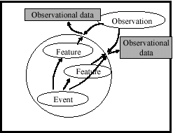
Figure 1. FEO model
2.3 Feature model
While a wide variety of spatio-temporal data model have been proposed in GIS until now (discussed in detail in Sekimoto, Shibasaki (1999)), representation with object-oriented approach has been mainly used in the sense that object-oriented approach can represent the property of feature intuitively (See, for example, Worboys(1990)). In this flow ISO/TC211, international standardization activity of geographic information, started in 1994 and has proposed General Feature Model as conceptual model of geographic information. Spatial schema and temporal schema, whose higher model is General Feature Model, are defined and consist of each geometric primitive and topological primitive (ISO/TC211 (1999)).
In this study we follow ISO/TC211 about representation of features, and also follow ota (1999), extending ISO/TC211 in terms of including mobile feature. In other words, feature has
Though it is necessary to develop conceptual model with its uncertainty, few works can be seen (For example, Shibasaki (1994)) and this uncertainty remains to be studied after this paper.
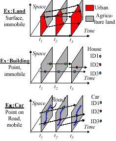
Figure 2. Feature example
2.4 Event model
Generally, event has been understood in the context of change point in the field of database (For example, Peuquet (1995)). But considering event as an existence which affects feature, such as earthquake, traffic accident or development project, event must have spatio-temporal behavior. This is described by impact model. So event has following components.
The way of explanation of observational data has an classical but difficult problem. Though Sinton (1978) claimed that geographic information has three dimensions - time, space and attribute - and each dimension is fixed, measured or controlled, this remains the problem that attribute dimension is handled like the other two dimensions. It means that geographic information, equivalent to observational data in this paper, has some sense like feature object. In our position observational data is the output result of an attribute of feature measured by observation controlling time and space, and this control system is sampling model. An item showing whether observational data is specified to feature or not can reflect the difference between Euler observation and Lagrange observation. Euler observation measures the aspects of features by field, and Lagrange observation measures the aspects of specified feature by flow. For example, measurement only at an intersection or measurement using video camera can capture the state of unspecified cars. Besides this usual data, measured data by GPS on some specified car is expected to be integrated. That's why an item showing specified condition is important. Observation model has
Though it is only natural to need feature model the necessity of event model and observation model is considered as follows.
Real world consists of a wide variety of features, which have internal changes and changes by external impact. External impact means that another feature gives some impact on the feature like car accident, but also means external abstract cause such as an earthquake, climate or amendment. Of course these can be represented as feature, but it is much easier to handle to regard these external abstract impact as event when we introduce a control concept like national land management, especially in GIS which aims to represent and estimate the real world efficiently and naturally.
This shows that it is closely related to the following matters. Namely in Artificial Intelligence (AI) and Control Engineering, studies have been done in terms of how to describe the real world in the computer, considering how the dynamic system like robot or plant adapts to the outside world. For example, Allen (1984) and Mcdermott (1982) have proposed the existence of event in order to overcome the poor expression ofsituation calculus in 1970's. Particularly Allen and Ferguson (1994) classified and defined the kind of event.
As for observation it helps us to consider that how the robot regards the observational data. The explanation, that is, is that the state observed by observer results in the observational data with some errors. The state space representation (Figure 3) in the field of control engineering has the state space and the external disturbance affects to the state space, the observer that observes the state. Thus this shows that state space representation is appropriate for description of real world from a viewpoint of control concept above. FEO model, therefore, is conceptual model and more realistic approach for faithful representation and estimation of dynamical world in the computer.
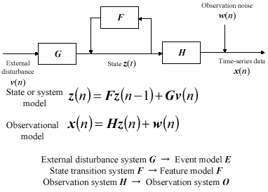
Figure 3. Comparison between state space representation and FEO model
3. Framework for the Estimation of the State of Feature Based On Feo Model.
While an estimation of feature must be done based on our proposed framework in the previous chapter, conceptual framework, integrating various kinds of estimation methods in each field, remains to be developed. This is an important future works. We can raise some effective estimation methods: Temporal, spatial reasoning extracting some meaningful information with symbolization techniques to the various kinds of knowledge (See, for example, O.Stock(1997). There was a project which aimed to introduce these reasoning techniques to GIS in NCGIA in early 1990's (Egenhofer, 1998).). Fuzzy reasoning including its uncertainty (See, for example, Console (1991)). These reasoning techniques have developed in AI. Or we have statistical method such as maximum likelihood method estimating probability field so that observed value is most likely one and carman filter with statistical method every changing dynamical system. Thus the importance of a common point between reasoning techniques in AI and statistical estimation is getting higher (Aso etc 1997). And mps analysis handles both aggregated data and disaggregated data with consistency in traffic field as mentioned in 2.5 (Kobayashi 1986).
4. An Example Application of Feo Model To Urban Traffic and Building Management
In this chapter, we apply our FEO model to the urban traffic and building management as one of main research field, and consider how observation data and event about feature such as car and building are explained. But because of the space of this paper the detail of this application will be referred in our presentation or Sekimoto and Shibasaki (1999).
5. Simulation Calculation about Updating Of Database
In this chapter.5 we demonstrated how the dynamical real world with observational data and event is put into the database by simulation calculation. Here we used building as simulation target, but validity of accuracy and assumption of modeling is not enough because this calculation is only for the simulation of database system. On account of paper space detail problem setting, formalization and results will be referred in our presentation or Sekimoto and Shibasaki (1999).
6. Conclusions
In this study we considered more intelligent database which can estimate, reconstruct and predict the dynamic phenomena in the real world from various data as GIS for next generation, and this time we proposed FEO model as conceptual representation model. And then we showed the way of applying to building management as case study. FEO model, thus, under systematization, gives some viewpoints classifying various kinds of observation data. Furthermore putting data into database in the forms of feature, event and observation enable us to arrange the accumulations of existing methods and models not only a wide variety of observational data.
After this, these steps
7. References
Abstract
Recently many kinds of spatio-temporal data are repeatedly acquired for almost the same objects because of the recent rapid progress of data acquisition technology. We have strong needs to use many kinds of fragmentary data, in order to estimate the dynamic changes of feature more accurately. It is necessary to establish or develop a framework of GIS, which allows to estimate, reconstruct and predict the phenomena in the real world by integrating various kinds of data. In this study we propose FEO (Feature/Event/Observation) model as conceptual framework for dynamic revision of spatio-temporal database. FEO model will be a part of the basis of intelligent GIS, which can reconstruct phenomena in the real world.
1. Introduction
1.1 Various kinds of needs
Geographic Information System (GIS) is expected to apply to a wide variety of fields, not only to the existing fields such as facility management of lifeline, fixed property management for taxation or emergency support after disasters, but also monitoring of the traffic congestion, provision of guidance information in Intelligent Transport System (ITS), and the support of the marketing activities. In these fields it will be required to collect information on phenomena changing dynamically, to understand the situation, and furthermore to predict to the future movement of the phenomena. Therefore data with finer resolution of time, space and attribute will be needed for spatio-temporal database compared to the resolution of existing maps or statistics.
1.2 Development of acquisition technology of spatio-temporal data
Because of development of sensor technology or network technology, the technological capability of collection and measurement of spatial data has been expanding. For example there is a survey technology to measure the three dimensional shape data of buildings using laser scanner and video image (Zhao and Shibasaki, 1997). It means that we can get three dimensional data of buildings from various angle using these new technology with existing photogrammetry. On the other hand, the monitoring technology of the route choice activities of cars using automatic recognition of vehicle number captured by video camera, or the monitoring technology of moving activities of people using PHS are put to practical use, and these technology will be expected to contribute to capture the spatio-temporal phenomena.
1.3 GIS of next generation
As we mentioned previous section, these collection and measurement technology of spatio-temporal data, with finer resolution, have enabled to measure the same object repeatedly from various angles, to acquire data of aspects which was not captured before. The system, which can estimate the spatio-temporal distributions and changes of features (in this study cars and people are included in features as mobile ones) with real-time processing taking in monitoring data occurring continuously, is regarded as a form of GIS of next generation.
1.4 Lack of interaction between data acquisition and database development
However, we cannot always get the data just corresponding to each needs of a wide variety of applications mentioned before. We need the process, in which the distributions and the changes of objects are estimated interpreting various data from the measuring and monitoring process. Even in the development and updating process of GIS database from existing photogrammetry, previous understanding of the changes of buildings from administrative data or ground survey data in the narrow road area, in which we cannot measure adequately, enable to help the development of database more accurately.
When we take a general view of the study about acquisition and integration of spatio-temporal data and about development and management of database from a viewpoint of realizing a next generation GIS above, both studies have been developed separately. In other words "edited" data representing the spatial distributions or temporal changes are made at first and put them into the database. In these assumptions both studies have proceeded.
For the reason above, much less works about unify of the way of putting observational data into database and the way of integration of the database can be seen.
On the other hands, many works about spatio-temporal database have been mainly done from a viewpoint of how to realize database effectively based on a assumption of the existence of "edited", "well-arranged" data above (For example, Langran:1992). These approaches, however, have at least some problems that the process to estimate the states of features exists separately and that observational data are scattered without putting into database and whose relations to the corresponding feature tend to be unclear. Furthermore we have some possibilities of lacking in necessary information, other than observational data, when estimating. The reason is that GIS database is not designed for estimation of the states of features.
1.5 Development of representation model for "extended" spatio-temporal database
It is essential to unify the process of data acquisition and integration and the process of database development and updating, and then to develop "extended" database managing the data about features including observational data to overcome these problems above. For that object various problems about conceptual model representing spatio-temporal changes of features, implementation of database based on this conceptual model, and estimation model for the states and changes of features, should be solved.
In this study chapter 2 introduces our conceptual model for representing "extended" spatio-temporal database including observational data, not only feature data. Chapter 3 then discusses about the estimation method with our proposed model. At last Chapter 4 and 5 demonstrates application possibility with some simple examples.
Of course in some fields systems or methods to estimate the states of features from various kinds of observational data are investigated according to each property of feature and observation means. But these investigations have started only recently and have not spread to the other fields. The investigations about conceptual model as more general model will be expected to contribute to the evaluation of each existing integration method or database management, exploration of the new fields, and further development of each method.
2. Proposal of Feo Model
Chapter 2 proposes our FEO model as conceptual representation model, including observational data not only features, for "extended" spatio-temporal database.
2.1 Basic concept
In order to realize "extended" spatio-temporal database as we mentioned before, requirement for representation model is understood below.
- Conceptual model representing spatio-temporal distributions and changes of features with their uncertainty
- Representation model including even observational data as explicit spatio-temporal data, having distinguish between data representing spatio-temporal distributions or changes of features and observational data which distributions and changes of feature are estimated or reconstructed based on.
- Representation model of event as external cause because features have their internal changes and their changes by external causes.
2.2 Definition of FEO model
FEO model consists of feature, event and observation model. Feature is objects such as car, people and building in the real world. Event is a spatio-temporal cause, which affects feature. Observation is the thing that observes event and feature. Observation data, therefore, is the result of observed feature and event by observation (Figure 1).
Figure 1. FEO model
2.3 Feature model
While a wide variety of spatio-temporal data model have been proposed in GIS until now (discussed in detail in Sekimoto, Shibasaki (1999)), representation with object-oriented approach has been mainly used in the sense that object-oriented approach can represent the property of feature intuitively (See, for example, Worboys(1990)). In this flow ISO/TC211, international standardization activity of geographic information, started in 1994 and has proposed General Feature Model as conceptual model of geographic information. Spatial schema and temporal schema, whose higher model is General Feature Model, are defined and consist of each geometric primitive and topological primitive (ISO/TC211 (1999)).
In this study we follow ISO/TC211 about representation of features, and also follow ota (1999), extending ISO/TC211 in terms of including mobile feature. In other words, feature has
- feature start, end
- feature behavior
- internal change
- effect to the other features (action)
- feature relationship
- feature attribute
Though it is necessary to develop conceptual model with its uncertainty, few works can be seen (For example, Shibasaki (1994)) and this uncertainty remains to be studied after this paper.
Figure 2. Feature example
2.4 Event model
Generally, event has been understood in the context of change point in the field of database (For example, Peuquet (1995)). But considering event as an existence which affects feature, such as earthquake, traffic accident or development project, event must have spatio-temporal behavior. This is described by impact model. So event has following components.
- Event start, end
- Event behavior
- internal change
- effect to features (impact model)
- impact method
- impact object
- feature type, relationship, attribute, spatio-temporal range
- Event relationship
- Event attribute
The way of explanation of observational data has an classical but difficult problem. Though Sinton (1978) claimed that geographic information has three dimensions - time, space and attribute - and each dimension is fixed, measured or controlled, this remains the problem that attribute dimension is handled like the other two dimensions. It means that geographic information, equivalent to observational data in this paper, has some sense like feature object. In our position observational data is the output result of an attribute of feature measured by observation controlling time and space, and this control system is sampling model. An item showing whether observational data is specified to feature or not can reflect the difference between Euler observation and Lagrange observation. Euler observation measures the aspects of features by field, and Lagrange observation measures the aspects of specified feature by flow. For example, measurement only at an intersection or measurement using video camera can capture the state of unspecified cars. Besides this usual data, measured data by GPS on some specified car is expected to be integrated. That's why an item showing specified condition is important. Observation model has
- Observation start, end
- Observation behavior
- internal change
- sampling model
- sampling method
- sampling object
- feature/event type (with an index of specified feature/event or not)
- feature/event relationship, attribute, spatio-temporal range
- sampling result (observational data)
- sampling error (observational error)
- Observation relationship
- Observation attribute
Though it is only natural to need feature model the necessity of event model and observation model is considered as follows.
Real world consists of a wide variety of features, which have internal changes and changes by external impact. External impact means that another feature gives some impact on the feature like car accident, but also means external abstract cause such as an earthquake, climate or amendment. Of course these can be represented as feature, but it is much easier to handle to regard these external abstract impact as event when we introduce a control concept like national land management, especially in GIS which aims to represent and estimate the real world efficiently and naturally.
This shows that it is closely related to the following matters. Namely in Artificial Intelligence (AI) and Control Engineering, studies have been done in terms of how to describe the real world in the computer, considering how the dynamic system like robot or plant adapts to the outside world. For example, Allen (1984) and Mcdermott (1982) have proposed the existence of event in order to overcome the poor expression ofsituation calculus in 1970's. Particularly Allen and Ferguson (1994) classified and defined the kind of event.
As for observation it helps us to consider that how the robot regards the observational data. The explanation, that is, is that the state observed by observer results in the observational data with some errors. The state space representation (Figure 3) in the field of control engineering has the state space and the external disturbance affects to the state space, the observer that observes the state. Thus this shows that state space representation is appropriate for description of real world from a viewpoint of control concept above. FEO model, therefore, is conceptual model and more realistic approach for faithful representation and estimation of dynamical world in the computer.
Figure 3. Comparison between state space representation and FEO model
3. Framework for the Estimation of the State of Feature Based On Feo Model.
While an estimation of feature must be done based on our proposed framework in the previous chapter, conceptual framework, integrating various kinds of estimation methods in each field, remains to be developed. This is an important future works. We can raise some effective estimation methods: Temporal, spatial reasoning extracting some meaningful information with symbolization techniques to the various kinds of knowledge (See, for example, O.Stock(1997). There was a project which aimed to introduce these reasoning techniques to GIS in NCGIA in early 1990's (Egenhofer, 1998).). Fuzzy reasoning including its uncertainty (See, for example, Console (1991)). These reasoning techniques have developed in AI. Or we have statistical method such as maximum likelihood method estimating probability field so that observed value is most likely one and carman filter with statistical method every changing dynamical system. Thus the importance of a common point between reasoning techniques in AI and statistical estimation is getting higher (Aso etc 1997). And mps analysis handles both aggregated data and disaggregated data with consistency in traffic field as mentioned in 2.5 (Kobayashi 1986).
4. An Example Application of Feo Model To Urban Traffic and Building Management
In this chapter, we apply our FEO model to the urban traffic and building management as one of main research field, and consider how observation data and event about feature such as car and building are explained. But because of the space of this paper the detail of this application will be referred in our presentation or Sekimoto and Shibasaki (1999).
5. Simulation Calculation about Updating Of Database
In this chapter.5 we demonstrated how the dynamical real world with observational data and event is put into the database by simulation calculation. Here we used building as simulation target, but validity of accuracy and assumption of modeling is not enough because this calculation is only for the simulation of database system. On account of paper space detail problem setting, formalization and results will be referred in our presentation or Sekimoto and Shibasaki (1999).
6. Conclusions
In this study we considered more intelligent database which can estimate, reconstruct and predict the dynamic phenomena in the real world from various data as GIS for next generation, and this time we proposed FEO model as conceptual representation model. And then we showed the way of applying to building management as case study. FEO model, thus, under systematization, gives some viewpoints classifying various kinds of observation data. Furthermore putting data into database in the forms of feature, event and observation enable us to arrange the accumulations of existing methods and models not only a wide variety of observational data.
After this, these steps
- Improvement of FEO model as conceptual model
- Implementation of database system based on FEO model
- Application calculation dealing with some case studies
7. References
- Asoh, H., Akaho, S., Motomura, Y., 1997. Statistical Inference and Inference in AI. Journal of Japanese Society for Artificial Intelligence, 12(2), pp.196-203.
- Ota, M., 1999. The Spatiotemporal Schema for Geographic Information Systems. Theory and Applications of GIS, 7(1), pp.37-44.
- Kobayashi, K., 1987. Application of entropy theory to urban traffic, Planning of Civil Engineering, 10, pp.291-298.
- Shibasaki, R. et al., 1996. Present situation of ISO standardization about geographic information, Photogrammetry and Remote Sensing, 5(6), pp.4-22.
- Sekimoto, Y., Shibasaki, R., 1999. Review of feature representation in spatio-temporal integration, The second Virtual conference of geographic information system.
- Sekimoto, Y., Shibasaki, R., 1999. Conceptual data model for dynamic updating of spatial-database, Theory and Applications of GIS, to be appeared.
- Allen, J., 1984 Towards a general theory of action and time, Journal of Artificial Intelligence Research, 23, pp.123-154.
- Allen, J., Ferguson, G., 1994. Actions and events in interval temporal logic, Journal of Logic and Computation, 4, pp.531-579.
- Console, L., et al., 1991. Fuzzy temporal reasoning on causal models, International Journal of Intelligent System, 6, 107-133.
- Egenhofer, M., Golledge, R eds., 1998. Spatial and temporal reasoning in geographic information systems. New York.Oxford University Press.
- INT 15046-1,7,8,9., 1998. ISO/TC211.
- Langran, G., 1992. Time in geographic information systems. London.Taylor and Francis. McDermott, D., 1982. A temporal logic for reasoning about process and plans, Cognitive Science, 6, 101-155.
- Peuquet, J., 1995. An event-based spatiotemporal data model (ESTDM) for temporal analysis of geographical data, International Journal of Geographical Information Systems, 9, 7-24.
- Shibasaki, R., 1994. Handling spatio-temporal uncertainties of geo-objects for dynamic update of GIS databases from multi-source data, International Society for Photogrammetry and Remote Sensing Com..Midterm Symposium, 30, 761-768.
- Sinton, D., 1978. The inherent structure of information as a constraint to analysis: mapped thematic data as a case study, in Harvard Papers on Geographic Information Systems, ed. Dutton G, Addison-Wesley: Reading MA.
- Stock, O eds., 1997. Spatial and temporal reasoning. Netherlands.Kluwer Academic Publishers. Worboys, M., 1990. Object-oriented data modeling for spatial databases, International Journal of Geographical Information Systems, 4, 369-383.
- Zhao, H., Shibasaki, R., 1997. Automated registration of ground-based laser range image for reconstructing urban 3D object, IAPRS, 32, Part3-4W2, 27-34.