| GISdevelopment.net ---> AARS ---> ACRS 1999 ---> Poster Session 2 |
Issues on the Design of China
Imaging Altimeter (CIALT)
Yoshihide SEKIMOTO, Ryosuke
SHIBASAKI
Yunhua Zhang, Jingshan Jiang
Maotang Li Ke Xu Dehai Zhang Jing Li Heguang Liu
Center for Space Science and Applied Research, Chinese Academy of Sciences
Tel: 86-10-62582850 Fax: 86-10-62576921
Email:yhzhang@nc.poac.ac.cn
Tel: 86-10-62559575 Fax: 86-10-62559575
Email: mailto:jsjiang@center.cssar.ac.cn
Abstract: the principle of china imaging
altimeter has been introduced. Some key issues on the system design, such
as antenna, baseline, observation angle, PRF, signal bandwidth,
compression in azimuthal and range direction, and finally tracking
algorithm have been discussed, also some preliminary results have been
given.
I. Introduction
In recent two decades, the development of microwave remote sensing technologies and its applications have experienced a rapid progress. Microwave sensors can provide one or two-dimensional useful data. For example, altimeter can provide one-dimensional height profile of ocean surface; scatterometer can provide two-dimensional wind vector on the ocean surface; radiometer can provide one-dimensional temperature or vapor profile of the atmosphere and the ordinary SAR can provide two-dimensional high-resolution image. As the application of microwave remote sensing becomes more and more wide and more and more far-reaching, one-dimensional or two-dimensional data (or image) cannot fulfill the requirements. So, three-dimensional data (image) is highly demanded now. They are one of the fundamental data for digital globe.
Up to now, three-dimensional image can be obtained by interferometric SAR through two approaches, one is repeat pass with single antenna and another one is single pass with two antennae. Aircraft borne interferometric systems[1-2] using the second approach have been developed several years ago, but the second approach is difficult to realize in space case.
Traditional radar altimeter has proven to be very useful for the study of oceanic science and oceanic environmental monitory, usually however, it can not be used for land and cannot be used to get image. In recent years, several new conceptual imaging altimeters have been proposed[3-6]. They are called scanning altimeter, or SAR altimeter etc.
In this paper, we give an introduction to our preliminary research on imaging altimeter (China Imaging Altimeter, CIALT)[7], which is supported by china high-tech research and development program. The object of this project is to develop a three-dimensional imaging altimeter system, which can be, applied both to ocean, ocean ice and land use. Firstly, we introduce the principle, and then we discuss about some key issues in the design of CIALT.
II. Principle of CIALT
The principle of CIALT concludes as the following four aspects:
1. Off-nadir looking
Off-nadir looking makes the swath more wide compared with traditional nadir looking and at the same time, the resolution in height can transfer to resolution in ground range.
2. Using synthetic aperture signal pro-cessing to obtain azimuthal resolution
Focused or unfocused synthetic aperture signal processing can be applied to improve the azimuthal resolution
3. Incorporation of pulse limited and beam limited
When used in ocean case, pulse limited is applied to obtain average sea level, significant wave height. When imaging, beam limited is applied to achieve wider swath. Interfero-metric information is used to obtain the height value corresponding to pixel, so three-dimensional imaging can be realized.
4. Off-set center of gravity (OCOG) tracking algorithm
When used in ocean ice and land, the measurement of average height of the surface and height tracking are realized through OCOG algorithm. This accurate average height value can be used as a benchmark when using interferometric information to obtain the pixel height.
III. Key issues on the design of CIALT
In this section, we will discuss some key issues on the design of CIALT, such as antenna, baseline, observation angle, PRF, signal bandwidth, compression algorithm in azimuthal and range direction and tracking algorithm.
1. Antenna design
In order to achieve more wide coverage, elliptical beamwidth is preferable to adopt unlike conventional altimeter in which circle symmetrical beamwidth is usually used. Obviously knifing parabolic antenna is one of better candidate with high gain and lightweight. Conical rectangular horn antenna is appropriate to be used as feed. The dimension of knifing dish antenna is 0.7m*2.0m.
Fig. 1 and Fig. 2 dipict the pattern of feed and antenna respectively.
2. Baseline design
The length of baseline should be optimized with S/N, imaging looks and geometrical design difficulty. We know that for the two antenna interferometric system (with a horizontal baseline), the correlation between the echoes received by two antennae decreases as the baseline increases. When the baseline equals BC , the correlation becomes zero[8].

Where Ry is the ground range resolution. Baseline length can be optimized according to the relation between the phase uncertainty ( ef ) and signal to noise ratio (SNR) and number of looks (NL)[9]:
Where g is decorrelation coefficient.
In practice, the baseline length B is chosen about 0.1 to 0.2 times of BC trading off the sensitivity of phase measurement and the engineering complexity in realizing the interferometric system. In our design, the length of baseline B is three meters.
3. Observation angle
The observation angle should be designed compatible with the accuracy of significant wave height, range resolution and the length of baseline. In ocean observation, when the antenna is nadir looking, the echo model can be described using Brown’s Model. If the antenna is off-nadir looking for a small angle, the Brown’s Model is still appropriate to use after making some modifications. From equation (1), one can see that, the larger the off nadir looking angle, the longer the length of baseline is needed under the same slope range, however, the higher ground range resolution and the wider swath can be achieved.
Above all, the off nadir angle is better in the range of several degrees. In our design, 2° off nadir angle is used.
Fig. 3 indicates the average return response of a rectangular pulse with nadir looking and Fig. 4 indicates he average return response of a rectangular pulse with off nadir 2° looking. Comparing these two figures, one can see, the return shapes are quite different. In the off-nadir case, the discrimination between echo shapes at small SWH is not as clear as that of nadir case.
4. PRF design
PRF is very important for constraining the azimuthal and range ambiguity, not loosing Doppler information, and lowering down the data rate.
In our system design, the observation angle is very small, and the swath is also very narrow compared with conventional SAR system, so the range ambiguity is not serious. We can select PRF simply according to the following equation:
fd<PRF<c/2(Rmax-Rmin) (4)
Where Rmin and Rmax are the near slope range and far slope range.
5. Signal bandwidth
The wider the transmitted signal bandwidth, the higher the accuracy in range measurement, but the narrower the tracking scope. Therefor according to the different surface characteristics of ocean, oceanic ice and land, the bandwidth should be different. In CIALT, three bandwidths is used, they are 320MHz, 80MHz and 20MHz respectively. These three chirps are generated digitally, so the change of bandwidth according to different surface is easy to realize.
6. Compression in range direction
Full-deramp technique and matched filtering technique can be used to complete range compression, but they are fit to different cases. In CIALT, high speed A/D and matched filter is involved.
7. Compression in azimuth direction
Focused or unfocused processing should be selected according to the resolution requirement, complexity of system, and the operational height of platform. In CIALT, unfocused processing is enough to meet the design goal.
8. Tracking Algorithm
In order to be able applied to ocean, oceanic ice and land altogether, model-free tracker should be designed. Tracking algorithm based on offset center of gravity (OCOG) can meet the requirement of model-free tracker. In this algorithm, the height error is linear across the entire range window and it is independent of pulse shape. In OCOG algorithm, there are only two parameters to be estimated from echo profile, i.e. pulse amplitude, A, and the pulse width W. According to them, errors signals which control height and gain loops are generated. When this error become large and the echo will be outside the tracking window, so the altitude resolution will be degraded. This results in the broadening of tracking window to capture the echo again.
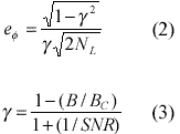
IV. Operation Modes
CIALT includes three operation modes, i.e. ocean mode, ocean ice mode and land modes. The signal bandwidths of the three modes are 320MHz, 80MHz and 20MHz respectively. Table 1 summarizes the typical technical indexes designed. Fig. 5 gives out the sketch diagram of CIALT system.
Table 1 Typical technical indexes
designed
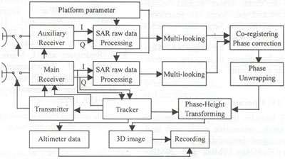
Fig.5 Sketch diagram of CIALT
References
I. Introduction
In recent two decades, the development of microwave remote sensing technologies and its applications have experienced a rapid progress. Microwave sensors can provide one or two-dimensional useful data. For example, altimeter can provide one-dimensional height profile of ocean surface; scatterometer can provide two-dimensional wind vector on the ocean surface; radiometer can provide one-dimensional temperature or vapor profile of the atmosphere and the ordinary SAR can provide two-dimensional high-resolution image. As the application of microwave remote sensing becomes more and more wide and more and more far-reaching, one-dimensional or two-dimensional data (or image) cannot fulfill the requirements. So, three-dimensional data (image) is highly demanded now. They are one of the fundamental data for digital globe.
Up to now, three-dimensional image can be obtained by interferometric SAR through two approaches, one is repeat pass with single antenna and another one is single pass with two antennae. Aircraft borne interferometric systems[1-2] using the second approach have been developed several years ago, but the second approach is difficult to realize in space case.
Traditional radar altimeter has proven to be very useful for the study of oceanic science and oceanic environmental monitory, usually however, it can not be used for land and cannot be used to get image. In recent years, several new conceptual imaging altimeters have been proposed[3-6]. They are called scanning altimeter, or SAR altimeter etc.
In this paper, we give an introduction to our preliminary research on imaging altimeter (China Imaging Altimeter, CIALT)[7], which is supported by china high-tech research and development program. The object of this project is to develop a three-dimensional imaging altimeter system, which can be, applied both to ocean, ocean ice and land use. Firstly, we introduce the principle, and then we discuss about some key issues in the design of CIALT.
II. Principle of CIALT
The principle of CIALT concludes as the following four aspects:
1. Off-nadir looking
Off-nadir looking makes the swath more wide compared with traditional nadir looking and at the same time, the resolution in height can transfer to resolution in ground range.
2. Using synthetic aperture signal pro-cessing to obtain azimuthal resolution
Focused or unfocused synthetic aperture signal processing can be applied to improve the azimuthal resolution
3. Incorporation of pulse limited and beam limited
When used in ocean case, pulse limited is applied to obtain average sea level, significant wave height. When imaging, beam limited is applied to achieve wider swath. Interfero-metric information is used to obtain the height value corresponding to pixel, so three-dimensional imaging can be realized.
4. Off-set center of gravity (OCOG) tracking algorithm
When used in ocean ice and land, the measurement of average height of the surface and height tracking are realized through OCOG algorithm. This accurate average height value can be used as a benchmark when using interferometric information to obtain the pixel height.
 Fig.1 Designed feed pattern |
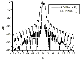 Fig.2 Designed antenna pattern |
III. Key issues on the design of CIALT
In this section, we will discuss some key issues on the design of CIALT, such as antenna, baseline, observation angle, PRF, signal bandwidth, compression algorithm in azimuthal and range direction and tracking algorithm.
1. Antenna design
In order to achieve more wide coverage, elliptical beamwidth is preferable to adopt unlike conventional altimeter in which circle symmetrical beamwidth is usually used. Obviously knifing parabolic antenna is one of better candidate with high gain and lightweight. Conical rectangular horn antenna is appropriate to be used as feed. The dimension of knifing dish antenna is 0.7m*2.0m.
Fig. 1 and Fig. 2 dipict the pattern of feed and antenna respectively.
2. Baseline design
The length of baseline should be optimized with S/N, imaging looks and geometrical design difficulty. We know that for the two antenna interferometric system (with a horizontal baseline), the correlation between the echoes received by two antennae decreases as the baseline increases. When the baseline equals BC , the correlation becomes zero[8].
Where Ry is the ground range resolution. Baseline length can be optimized according to the relation between the phase uncertainty ( ef ) and signal to noise ratio (SNR) and number of looks (NL)[9]:
Where g is decorrelation coefficient.
In practice, the baseline length B is chosen about 0.1 to 0.2 times of BC trading off the sensitivity of phase measurement and the engineering complexity in realizing the interferometric system. In our design, the length of baseline B is three meters.
3. Observation angle
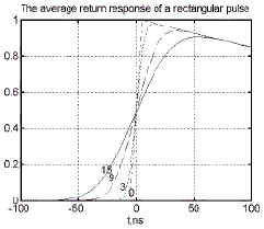
Fig.3 The average return response of a rectangular pulse with nadir looking |
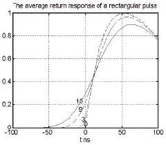
Fig.4 The average return response of a rectangular pulse with off-nadir 2° looking |
The observation angle should be designed compatible with the accuracy of significant wave height, range resolution and the length of baseline. In ocean observation, when the antenna is nadir looking, the echo model can be described using Brown’s Model. If the antenna is off-nadir looking for a small angle, the Brown’s Model is still appropriate to use after making some modifications. From equation (1), one can see that, the larger the off nadir looking angle, the longer the length of baseline is needed under the same slope range, however, the higher ground range resolution and the wider swath can be achieved.
Above all, the off nadir angle is better in the range of several degrees. In our design, 2° off nadir angle is used.
Fig. 3 indicates the average return response of a rectangular pulse with nadir looking and Fig. 4 indicates he average return response of a rectangular pulse with off nadir 2° looking. Comparing these two figures, one can see, the return shapes are quite different. In the off-nadir case, the discrimination between echo shapes at small SWH is not as clear as that of nadir case.
4. PRF design
PRF is very important for constraining the azimuthal and range ambiguity, not loosing Doppler information, and lowering down the data rate.
In our system design, the observation angle is very small, and the swath is also very narrow compared with conventional SAR system, so the range ambiguity is not serious. We can select PRF simply according to the following equation:
Where Rmin and Rmax are the near slope range and far slope range.
5. Signal bandwidth
The wider the transmitted signal bandwidth, the higher the accuracy in range measurement, but the narrower the tracking scope. Therefor according to the different surface characteristics of ocean, oceanic ice and land, the bandwidth should be different. In CIALT, three bandwidths is used, they are 320MHz, 80MHz and 20MHz respectively. These three chirps are generated digitally, so the change of bandwidth according to different surface is easy to realize.
6. Compression in range direction
Full-deramp technique and matched filtering technique can be used to complete range compression, but they are fit to different cases. In CIALT, high speed A/D and matched filter is involved.
7. Compression in azimuth direction
Focused or unfocused processing should be selected according to the resolution requirement, complexity of system, and the operational height of platform. In CIALT, unfocused processing is enough to meet the design goal.
8. Tracking Algorithm
In order to be able applied to ocean, oceanic ice and land altogether, model-free tracker should be designed. Tracking algorithm based on offset center of gravity (OCOG) can meet the requirement of model-free tracker. In this algorithm, the height error is linear across the entire range window and it is independent of pulse shape. In OCOG algorithm, there are only two parameters to be estimated from echo profile, i.e. pulse amplitude, A, and the pulse width W. According to them, errors signals which control height and gain loops are generated. When this error become large and the echo will be outside the tracking window, so the altitude resolution will be degraded. This results in the broadening of tracking window to capture the echo again.
IV. Operation Modes
CIALT includes three operation modes, i.e. ocean mode, ocean ice mode and land modes. The signal bandwidths of the three modes are 320MHz, 80MHz and 20MHz respectively. Table 1 summarizes the typical technical indexes designed. Fig. 5 gives out the sketch diagram of CIALT system.
| Operative Height | 800 Km |
| Radar Frequency | 13.5 GHz |
| Wavelength | 0.022m |
| Polarization | VV |
| Transmitted power(peak) | 1.1kW |
| Singnal bandwidth | 320,80,20 MHz |
| Pulse duration | 24ms |
| Pulse repetition frequency(PRF) | 2000 Hz |
| Antenna aperture | 0.7m * 2.0m |
| 3db beamwidth | 0.6°*2.0° |
| Baseline length | 3.0m |
| Off-nadir observation angle | 2.0° |
| Swath | 22km |
| Ground resolution | 100m*400m(azimuth*range) |
| Height accuracy(average) | Ocean:10.0cm, land:3m |
| Height accuracy(average) | Ocean:<m, land:5~10m |
Fig.5 Sketch diagram of CIALT
References
- H.A. Zebker, S.N.Madsen, et al., The TOPSAR Interferometric Radar Topo- graphic Mapping Instrument, IEEE Trans. On Geosci. Remote Sensing, Vol.30,933- 940,1992.
- Nikolaus P. Faller and Erich H. Meier, First Results with the Airborne Single-Pass DO-SAR Interferometer, IEEE Trans. On Geosci. Remote Sensing, Vol.33, 1230- 1237,1995.
- C.Elachi, K.E.IM, F.Li and E. Rodriguez, Global Digital Topography Mapping with A Synthetic Aperture Scanning Radar Altimeter, International Journal of Remote Sensing, Vol.11, No.4, 585-601, 1990.
- H.D., Griffiths, Synthetic Aperture Processing for Full-deramp Radar Altimeters, Electronics Letters, Vol.24, No.7 pp371-373., 1988.
- B.Purseyyed, H.D. Griffiths, A Synthetic Aperture Altimeter, Proceedings of IGARSS’88, 981-982,1988.
- G. Angino, F.Impagnatiello, C. Zelli, High Spatial Resolution Radar Altimetery for Global Earth Topography Mapping, Proceedings of IGARSS’97, 15-17, 1997.
- Zhang Yunhua, Xu Ke, Li Maotang, Li Jing, Liu Heguang, Study on Spacceborne Topography Mapping Altimeter.
- Howard A. Zebker, Thomas G. Farr., Ronald P. Salazar, Timothy H. Dixon, Mapping the World’s Topography Using Radar Interferometry: The TOPSAT Mission, Proceedings of The IEEE, Vol.82, No.12, 1774-1786, 1994.
- E. Rodriguez and J. Marin, Theory and Design of Interferometric Synthetic Aperture Radars, Proceedings of Institute of Electronic Engineering, Vol.139, No.2, 147-159, 1992.