| GISdevelopment.net ---> AARS ---> ACRS 1999 ---> Poster Session 2 |
China Advanced Microwave
Remote Sensor
Heguang Liu, Jingshan
Jiang, Xiaolong Dong, Jing Li, Ke Xu
Center for Space Science and Applied Research, Chinese Academy of Science
P.O.Box 8701, Beijing 100080, P. R. China
Tel: 86-10-62582846, Fax: 86-10-62576921,
Email:mailto:hgliu@center.cssar.ac.cn
Tel: 86-10-62559575, Fax: 86-10-62559575,
Email:mailto:jsjiang@www.mirit.poac.ac.cn
Center for Space Science and Applied Research, Chinese Academy of Science
P.O.Box 8701, Beijing 100080, P. R. China
Tel: 86-10-62582846, Fax: 86-10-62576921,
Email:mailto:hgliu@center.cssar.ac.cn
Tel: 86-10-62559575, Fax: 86-10-62559575,
Email:mailto:jsjiang@www.mirit.poac.ac.cn
Abstract
This paper deals with the aim and the application of the spaceborne China Advanced Microwave Remote Sensor (CAMRS). The aim of this project is to develop the second generation China Multimode Microwave Remote Sensor (M3RS) in which the dual frequency altimeter, scanning scatterometer and multi-channel millimetre-wave radiometers are integrated together. Altimeter (ALT), scatterometer (SCAT) and radiometer (RAD) are all designed in module so they can be combined or decomposed arbitrarily according to different mission. This new sensor can be used to sea surface, atmosphere and land applications.
1.0 Introduction
Over the three decades, microwave remote sensing has evolved into an important tool for monitoring the atmospheres and surfaces of planetary objects, with special emphasis on observations of the planet earth. Sensors are very important part of microwave remote sensing and usually are divided into two groups according to their modes of operation: active and passive. Active modes are those that provide their own source of illumination and therefore contain a transmitter and a receiver, while Passive modes are simply receivers that measure the radiation emanating from the scene under observation. Active modes include imaging radar, SCAT and ALT, and passive modes are often referred to as microwave RAD. Active sensors have been used extensively for mapping geological structures and features. Particularly in those parts of the world where cloud cover presents a serious problem to optical sensors. Active modes also can used for other application areas, including vegetation mapping, discrimination of sea-ice types, measuring ocean wind speed and direction, mapping soil moisture content and snow water content, and land-use evaluation.
The CAMRS is a second generation M3RS, including scanning SCAT, the dual frequency ALT and multi-channel millimetre-wave RAD, in which active and passive modes are working synergistically. The primary goal of the sensor is to ocean and atmospheric research. The ALT mode can provide geoid, significant wave high and wind speed with precision satisfying to user requirement. SCAT mode will provide ocean wind field data and the RAD can provide on atmospheric data.
2.0 A brief description and key specification of the system
The CAMRS consists of seven operation modes and the mode combination can be selected in order of user requirements. The main modes are: ALT, SCAT, RAD, ALT+SCAT, ALT+RAD, SCAT+RAD and ALT+SCAT+RAD. The functional block diagram has shown in fig-1.
2.1 The dual frequency altimeter unit
Satellite altimetry is devoted to the active remote sensing of the ocean surface and thereby represents an important new source of measurements. These measurements are sufficient to provide all-weather independent observations of global topographic features, thus contributing to the accurate mapping of underwater features and the detection and measurement of ocean current, tides, and storm surges, as well as the monitoring of wave height on a global basis. The radar ALT is therefore an unique tool for studying the role that oceans play in the Earth’s climate system and for understanding climatic change on a global scale.
The radar ALT operates in the pulse-width limited mode, and use the full deramp system of pulse compression. The basic altimeter operation principle can be found in (Chelton, 1989).
The radar ALT operates at C-band and Ku-band respectively. The dual frequency design allows for height measurement corrections due to the ionospheric effects on the signal. This system was designed to operate from a space platform over the ocean with sea conditions ranging from 0.5 to 20 meters in significant wave height. The altitude resolution is 4.5cm. The significant wave height is 0.25m or <5%. The backscatter coefficient is 0.4dB.
The radar ALT has several improvements over previous China ALT.
Table 1. Radar Altimeter System
Parameters
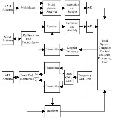
Figure1. The Block Diagram of the CAMRS
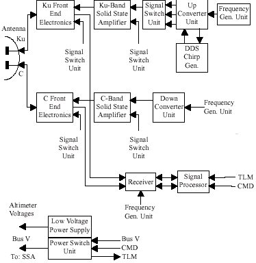
Figure2. The System Block Diagram of the Dual Frequency Altimeter
2.2 Scatterometer unit
The main purpose of microwave SCAT unit is to measure the backscattering coefficients of sea surface, ice and snow and so on. Using the backscattering coefficients, the ocean surface wind vector can be retrieved. The SCAT of CAMRS is a Ku band, dual-polarization, dual-pencil-beam, and conically scanned radar. Such a system has some advantages, such as low transmitted power requirement, wide sweeping width, simple system configuration and so on, to the fan-beam scatterometers of ERS1, ERS2, JERS, and other spaceborne scatterometers in operation.
The SCAT unit is composed of several parts including antenna, transmitter and frequency synthesizer, receiver, data processing and control. Fig.3 is the diagram of the SCAT unit.
System specifications
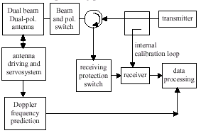
Fig.3 Diagram of the Scatterometer
2.3 The multifrequency radiometers unit
The main purpose of microwave RAD unit is to detect integrated water volume and temperature measurement of stratosphere.
The advantage of microwave RAD at 118.75GHz is as follows: 1) for the same size antenna, the space resolution of 118.75GHz is twice than that of 50-60GHz microwave RAD. The space resolution is one of the important characteristics of meteorological remote sensing. 2) The oxygen absorbing line is single and symmetric at 118.75GHz, so the double side band receiver can be designed and the noise figure and the sensitivity of the receiver can be improved. 3) A wide band receiver can be designed at 118.75GHz. Only use one wide band front-end, but multiple IF signal can be gotten by band pass filters. So the cost of hardware can be decreased. 4) The absorbing line at 118.75GHz is far away from the other oxygen absorbing line, so the effect of overlap can be ignored.
Figure 4 is the block diagram of microwave RAD unit. It includes antenna, receivers, computer and power supply. They share one antenna from 90-118.75GHz. So the antenna’s weight and volume can be decreased, and the scanning consideration also can be simplified. The diameter of the antenna is 20cm. Total power type is adopted for the design of microwave RAD. The main characteristics of microwave RAD unit are listed in table 2.
D: Diameter; t : Integration time; B: Bandwidth
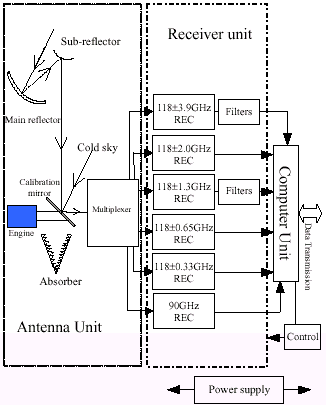
Figure 4 Block Diagram of Microwave Radiometer Unit
2.4 Computer Control and Data Processing Unit
Computer control and data processing unit(CCDPU) consists of two parts that are instrument control unit(ICU) and module data processing unit, showed by figure 5. The module data processing unit comprises ALT processing module, SCAT processing module and RAD processing module. CCDPU is designed to support incorporation for the three modules, independent work for each module, or incorporation for every two of the three modules.
ICU is charge of onboard data communication interface, mode control, distributing satellite attitude parameter, timing, and transferring measure and monitoring data.
ALT offers AGC value connected with the echo power, the evaluated slop value of return wave leading edge, delay time between the transmitting and receiving pulse, and wave shape sampling value. SCAT submits echo wave sampling value that can be used to calculate wind vector. RAD delivers different receiving paths sampling value. Monitoring data of the instrument's significant working point are also provided. All these values are packed together and sent to the ground station.
ICU can transfer remote instruction from ground station to each module to change their working mode and modify condition parameters.
The rule to achieve modularized design includes:
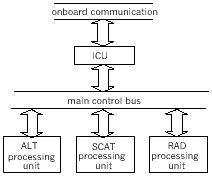
Figure 5 Computer Control and Data Processing Unit
3.0 Conclusion
As it result from the CAMRS description, the system design is at the state of art, from a system and technological point of view. Presently, an activity to evaluate the impact of hardware on system performance is still on progress.
4.0 References
This paper deals with the aim and the application of the spaceborne China Advanced Microwave Remote Sensor (CAMRS). The aim of this project is to develop the second generation China Multimode Microwave Remote Sensor (M3RS) in which the dual frequency altimeter, scanning scatterometer and multi-channel millimetre-wave radiometers are integrated together. Altimeter (ALT), scatterometer (SCAT) and radiometer (RAD) are all designed in module so they can be combined or decomposed arbitrarily according to different mission. This new sensor can be used to sea surface, atmosphere and land applications.
1.0 Introduction
Over the three decades, microwave remote sensing has evolved into an important tool for monitoring the atmospheres and surfaces of planetary objects, with special emphasis on observations of the planet earth. Sensors are very important part of microwave remote sensing and usually are divided into two groups according to their modes of operation: active and passive. Active modes are those that provide their own source of illumination and therefore contain a transmitter and a receiver, while Passive modes are simply receivers that measure the radiation emanating from the scene under observation. Active modes include imaging radar, SCAT and ALT, and passive modes are often referred to as microwave RAD. Active sensors have been used extensively for mapping geological structures and features. Particularly in those parts of the world where cloud cover presents a serious problem to optical sensors. Active modes also can used for other application areas, including vegetation mapping, discrimination of sea-ice types, measuring ocean wind speed and direction, mapping soil moisture content and snow water content, and land-use evaluation.
The CAMRS is a second generation M3RS, including scanning SCAT, the dual frequency ALT and multi-channel millimetre-wave RAD, in which active and passive modes are working synergistically. The primary goal of the sensor is to ocean and atmospheric research. The ALT mode can provide geoid, significant wave high and wind speed with precision satisfying to user requirement. SCAT mode will provide ocean wind field data and the RAD can provide on atmospheric data.
2.0 A brief description and key specification of the system
The CAMRS consists of seven operation modes and the mode combination can be selected in order of user requirements. The main modes are: ALT, SCAT, RAD, ALT+SCAT, ALT+RAD, SCAT+RAD and ALT+SCAT+RAD. The functional block diagram has shown in fig-1.
2.1 The dual frequency altimeter unit
Satellite altimetry is devoted to the active remote sensing of the ocean surface and thereby represents an important new source of measurements. These measurements are sufficient to provide all-weather independent observations of global topographic features, thus contributing to the accurate mapping of underwater features and the detection and measurement of ocean current, tides, and storm surges, as well as the monitoring of wave height on a global basis. The radar ALT is therefore an unique tool for studying the role that oceans play in the Earth’s climate system and for understanding climatic change on a global scale.
The radar ALT operates in the pulse-width limited mode, and use the full deramp system of pulse compression. The basic altimeter operation principle can be found in (Chelton, 1989).
The radar ALT operates at C-band and Ku-band respectively. The dual frequency design allows for height measurement corrections due to the ionospheric effects on the signal. This system was designed to operate from a space platform over the ocean with sea conditions ranging from 0.5 to 20 meters in significant wave height. The altitude resolution is 4.5cm. The significant wave height is 0.25m or <5%. The backscatter coefficient is 0.4dB.
The radar ALT has several improvements over previous China ALT.
- The dual frequency design allows for height measurement corrections due to the ionospheric effects on the signal.
- The new on-board processor
- Digital Chirp generated technology
- Solid-state transmitter
| Design parameter | Main channel | Common | Secondary channel |
| Altitude range, km | 800 | ||
| Operative Frequency, GHz | 13.7 | 5.35 | |
| Pulse Length, ms | 102 | 102 | |
| Pulse Bandwidth, MHz | 320, 80, 20 | 100 or160 | |
| Tx Peak Power, W | 5 | 20 | |
| PRF, Hz | 1000~4000 | 400~1000 | |
| Type of Antenna | Parabola | ||
| Antenna diameter, m | 1.5 | ||
| Antenna Gain, dB | 44 | 36 |
Figure1. The Block Diagram of the CAMRS
Figure2. The System Block Diagram of the Dual Frequency Altimeter
2.2 Scatterometer unit
The main purpose of microwave SCAT unit is to measure the backscattering coefficients of sea surface, ice and snow and so on. Using the backscattering coefficients, the ocean surface wind vector can be retrieved. The SCAT of CAMRS is a Ku band, dual-polarization, dual-pencil-beam, and conically scanned radar. Such a system has some advantages, such as low transmitted power requirement, wide sweeping width, simple system configuration and so on, to the fan-beam scatterometers of ERS1, ERS2, JERS, and other spaceborne scatterometers in operation.
The SCAT unit is composed of several parts including antenna, transmitter and frequency synthesizer, receiver, data processing and control. Fig.3 is the diagram of the SCAT unit.
System specifications
| Wind velocity range: | 2~30m/s |
| Wind velocity precision: | 2~20m/s: <2m/s; 20~30m/s: 10%rms |
| Wind direction range: | 0~360° |
| Wind direction precision: | <20° |
| Backscattering coefficient precision: | ±1.0dB |
| Spatial resolution: | 50 km |
| Backscattering dynamic range: | -40dB ~ +20dB |
| Polarization: | VV, HH |
| Frequency: | Ku-band: 13.4GHz |
| Platform altitude: | 800km, near-polar |
| Platform velocity: | 7.4556km/s |
| Orbit period: | 6043.4s(=1hr40min43.4s) |
| Antenna pointing precision: | <0.2° |
Fig.3 Diagram of the Scatterometer
2.3 The multifrequency radiometers unit
The main purpose of microwave RAD unit is to detect integrated water volume and temperature measurement of stratosphere.
The advantage of microwave RAD at 118.75GHz is as follows: 1) for the same size antenna, the space resolution of 118.75GHz is twice than that of 50-60GHz microwave RAD. The space resolution is one of the important characteristics of meteorological remote sensing. 2) The oxygen absorbing line is single and symmetric at 118.75GHz, so the double side band receiver can be designed and the noise figure and the sensitivity of the receiver can be improved. 3) A wide band receiver can be designed at 118.75GHz. Only use one wide band front-end, but multiple IF signal can be gotten by band pass filters. So the cost of hardware can be decreased. 4) The absorbing line at 118.75GHz is far away from the other oxygen absorbing line, so the effect of overlap can be ignored.
Figure 4 is the block diagram of microwave RAD unit. It includes antenna, receivers, computer and power supply. They share one antenna from 90-118.75GHz. So the antenna’s weight and volume can be decreased, and the scanning consideration also can be simplified. The diameter of the antenna is 20cm. Total power type is adopted for the design of microwave RAD. The main characteristics of microwave RAD unit are listed in table 2.
| Ch | Center freq. GHz | Dynamic range K | Scan angle | D * cm | TSYS K | t* ms | B * MHz | Sensitivity T K |
| 1 | 90 | 2.7-320 | ±40° | 20 | 2263.0 | 180 | 2000 | 0.2 |
| 2 | 118.75 ± 0.33 |
3610.0 | 180 | 200 | 0.6 | |||
| 3 | 118.75 ± 0.65 |
3610.0 | 180 | 350 | 0.5 | |||
| 4 | 118.75 ± 1.3 |
3610.0 | 180 | 500 | 0.4 | |||
| 5 | 118.75 ± 2.0 |
3610.0 | 180 | 600 | 0.4 | |||
| 6 | 118.75 ± 3.9 |
3610.0 | 180 | 600 | 0.4 |
D: Diameter; t : Integration time; B: Bandwidth
Figure 4 Block Diagram of Microwave Radiometer Unit
2.4 Computer Control and Data Processing Unit
Computer control and data processing unit(CCDPU) consists of two parts that are instrument control unit(ICU) and module data processing unit, showed by figure 5. The module data processing unit comprises ALT processing module, SCAT processing module and RAD processing module. CCDPU is designed to support incorporation for the three modules, independent work for each module, or incorporation for every two of the three modules.
ICU is charge of onboard data communication interface, mode control, distributing satellite attitude parameter, timing, and transferring measure and monitoring data.
ALT offers AGC value connected with the echo power, the evaluated slop value of return wave leading edge, delay time between the transmitting and receiving pulse, and wave shape sampling value. SCAT submits echo wave sampling value that can be used to calculate wind vector. RAD delivers different receiving paths sampling value. Monitoring data of the instrument's significant working point are also provided. All these values are packed together and sent to the ground station.
ICU can transfer remote instruction from ground station to each module to change their working mode and modify condition parameters.
The rule to achieve modularized design includes:
- Easily reunite for single module, two modules and three modules.
- Modularized design for hardware.
- Modularized design for software.
Figure 5 Computer Control and Data Processing Unit
3.0 Conclusion
As it result from the CAMRS description, the system design is at the state of art, from a system and technological point of view. Presently, an activity to evaluate the impact of hardware on system performance is still on progress.
4.0 References
- H.G.Liu, J.S.Jiang, Y.H.Chang, X.L.Dong, J.Li, and K.Xu, “Spaceborne Modularized Microwave Sensors with High Functional Density”, Proceeding of 49th International Astronautical Congress, IAF-98-B.3.03, October 1998
- J.S.Jiang, Z.F.Zheng, H.G.Liu, X.Zhang and Z.F.Fan, “China Advanced Microwave Remote Sensor,” Proceeding of 47th International Astronautical Congress, IAF-96-B.3.P107, October 1996
- D.B. Chelton, E.J. Walsh, and J.L. MacArthur, "Pulse Compression and Sea Level Tracking in Satellite Altimetry," J. Atmospheric and Oceanic Technol., Vol.6, No.3, pp.407-438, June 1989.
- G.S. Brown, “The Average Impulse Response of a Rough Surface and its Application,” IEEE Trans. on Antenna and Propagation, Vol. AP 25, No.1, pp. 67-74, January 1977.
- B.J. Lipa and D.E. Barrick, "Ocean Surface Height-Slope Probability Density Function from SEASAT Altimeter Echo," Journal of Geophysical Research, Vol. 86, No. C11, pp.10921- 10930, 1981.
- D.G.Long and M.W.Spencer, “Radar Backscatter Measurement Accuracy for a Spaceborne Pencil-Beam Scatterometer with Scatterometer with Transmit Modulation,” IEEE Trans. On Geosci. & Remote Sens., 35(1), pp.102-114, 1997
- M.W.Spencer, C.Wu and D.G.Long, “Tradeoffs in the Design of a Spaceborne Scanning Pencil-Beam Scatterometer: Application to SeaWinds,” IEEE Trans. On Geosci. & Remote Sens., 35(1), pp.115-126, 1997
- D.G.Long, “Wind Measurement Resolution for a Scanning pencil Beam Scatterometer,” IGARSS’94