| GISdevelopment.net ---> AARS ---> ACRS 1999 ---> Poster Session 2 |
Extend Progresses in
Synthetic Aperture Radar Technology
Zhu Minhui, Wu yirong
Institute of Electronics, Chinese Academy of Sciences
E=Mail:mhzhu@ie0.ie.ac.cn, wyr@ie0.ie.ac.cn
Institute of Electronics, Chinese Academy of Sciences
E=Mail:mhzhu@ie0.ie.ac.cn, wyr@ie0.ie.ac.cn
Abstract
In the recent years, China pays much attention into microwave remote sensing application. Synthetic Aperture Radar (SAR) sensor is being developed as a key geomatics data source. This paper presents the main R&D activities of SAR systems. It includes 4 parts of work on airborne SAR, spaceborne SAR, ground SAR processor and new generation's SAR technologies. Some good results are described.
1. Introduction
Synthetic Aperture Radar (SAR) is used to acquire high-resolution large-scale images of earth surface. The advantages of a SAR device are operations in all weather condition during the day and night circles of an orbit in order to complement the existing optical sensors. At present SAR becomes an important tool of active microwave remote sensors for environment monitoring and resource survey, military application in the world.
Since the end of 70’s, institute of Electronics, Chinese Academy of Sciences (IECAS) started to study on imaging radar technology for radar system design and signal processing methods as the main unit in China. As technological progresses are rapidly extended, SAR systems both airborne and spaceborne platforms form the major subjects in IECAS, not only to demonstrate its technological feasibility, but also to develop SAR engineering projects and exploit some of the new generation's SAR technology. Technical researchers have developed hardware and software dealing with data processing of high data rate. The applied researches on a variety of fields are widely extended such as Institute of Remote Sensing Application and users etc. Work on cartography, crop monitoring, disaster detection and monitoring, desertification assessment and new geographical information systems are increasingly involved.
2. The Airborne SAR System
Chinese organizations have bought several plans devoted to airborne SAR system. IECAS completed the first operational X-band airborne SAR with mono-polarization in early 80’s. Then we produced the first multi-polarization and multi-swath airborne SAR imaging system, which got radar images successfully, used for flood monitoring in the early 90’s. In above system, SAR raw data are gathered on-board the aircraft and stored on optical film recorder for subsequent data processing using optical correlator on the ground.
The first real-time on-board SAR imaging processor has been developed in 1994 in order to meet time urgent applications. It does SAR images processing on board the aircraft. The produced images can be displayed and recorded immediately to verify the SAR data acquired. In the same time a data downlink communication system is used, the produced images can be also displayed on ground monitoring system in time.
The radar system has worked very well under severe service conditions and produced a great number of mapping area images. An example of the digital images is shown in fig. 1. The boundaries between water and land are displayed very clearly. The river course, bridges and other prevention engineering works are also shown clearly. By use of these images and other known information, the scientists on geology and water conservancy can efficiently evaluate the effects of flooding to agriculture and properties.
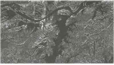
Fig. 1 Flooded Yangtze River. The Jiu-Jiang Area, 1998.
3. The spaceborne SAR system
At the end of 80's, we received a strong request of national high technology program. It started our campaign work on the spaceborne SAR system. IECAS was arranged as the chief department in the project and some other institutes from industry units also take part in the project. After the significant progresses of its key techniques, IECAS complete the design of L-SAR, resulting in production of the major specification to meet user's requirement. Hardware development is advanced. The instrument comprises two major functional groups, the central electronics and an active phased array antenna, which can be steered in one axis. IECAS completed L-SAR central electronics prototype in 1997. It was developed a demonstration system and got SAR digital image under the aircraft tests. In meantime, it is intended to use for a wide range of possible applied researches. Fig.2 is its testing result. China ancient great wall hidden under dry soil is clearly shown. It was built in northwest area about 1500 years ago.
The active microstrip patch antenna model with deployed units will be verified in near future.
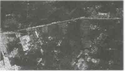
Fig. 2 The Yan-Chi Area. Ancient Great Wall Built 1400 Years Before Was Discovered.
Upon user community's request, the planned Chinese SAR is designed L band, HH polarization, changeable incidence angle and two operating modes. It will be carried on China made satellite with a circular sun-synchronized orbit.
4. SAR Ground Processor
SAR is the combination of coherent radar and imaging processing technique. The SAR processor must be designed to be suitable to the SAR imaging algorithm and deal with heavy computation load and high throughput. The high performance platforms such as super-PC based processor; workstation and the array processor are successfully used for the different user's requests. The SPECAN algorithm, Range/Doppler algorithm, Chirp-Scaling algorithm and their revised algorithms are developed in SAR processing for the different operating modes.
Presently Chinese receiving ground station is up graded to meet wide users’ requirements in getting microwave remote sensing data. Activities are now conducted to get within a reasonable time the capability to receive signals from ERS-1/2, Spot, Landsat 7 and Radarsat. SAR images are widely used for economic oriented application.
5. The New generation' SAR Technology
The serial projects of developing new generation's SAR technology supported by national high technology program have been deployed. Latest trends in SAR system are developing to new operating modes in order to provide more and more application.
In the recent years, China pays much attention into microwave remote sensing application. Synthetic Aperture Radar (SAR) sensor is being developed as a key geomatics data source. This paper presents the main R&D activities of SAR systems. It includes 4 parts of work on airborne SAR, spaceborne SAR, ground SAR processor and new generation's SAR technologies. Some good results are described.
1. Introduction
Synthetic Aperture Radar (SAR) is used to acquire high-resolution large-scale images of earth surface. The advantages of a SAR device are operations in all weather condition during the day and night circles of an orbit in order to complement the existing optical sensors. At present SAR becomes an important tool of active microwave remote sensors for environment monitoring and resource survey, military application in the world.
Since the end of 70’s, institute of Electronics, Chinese Academy of Sciences (IECAS) started to study on imaging radar technology for radar system design and signal processing methods as the main unit in China. As technological progresses are rapidly extended, SAR systems both airborne and spaceborne platforms form the major subjects in IECAS, not only to demonstrate its technological feasibility, but also to develop SAR engineering projects and exploit some of the new generation's SAR technology. Technical researchers have developed hardware and software dealing with data processing of high data rate. The applied researches on a variety of fields are widely extended such as Institute of Remote Sensing Application and users etc. Work on cartography, crop monitoring, disaster detection and monitoring, desertification assessment and new geographical information systems are increasingly involved.
2. The Airborne SAR System
Chinese organizations have bought several plans devoted to airborne SAR system. IECAS completed the first operational X-band airborne SAR with mono-polarization in early 80’s. Then we produced the first multi-polarization and multi-swath airborne SAR imaging system, which got radar images successfully, used for flood monitoring in the early 90’s. In above system, SAR raw data are gathered on-board the aircraft and stored on optical film recorder for subsequent data processing using optical correlator on the ground.
The first real-time on-board SAR imaging processor has been developed in 1994 in order to meet time urgent applications. It does SAR images processing on board the aircraft. The produced images can be displayed and recorded immediately to verify the SAR data acquired. In the same time a data downlink communication system is used, the produced images can be also displayed on ground monitoring system in time.
The radar system has worked very well under severe service conditions and produced a great number of mapping area images. An example of the digital images is shown in fig. 1. The boundaries between water and land are displayed very clearly. The river course, bridges and other prevention engineering works are also shown clearly. By use of these images and other known information, the scientists on geology and water conservancy can efficiently evaluate the effects of flooding to agriculture and properties.
Fig. 1 Flooded Yangtze River. The Jiu-Jiang Area, 1998.
3. The spaceborne SAR system
At the end of 80's, we received a strong request of national high technology program. It started our campaign work on the spaceborne SAR system. IECAS was arranged as the chief department in the project and some other institutes from industry units also take part in the project. After the significant progresses of its key techniques, IECAS complete the design of L-SAR, resulting in production of the major specification to meet user's requirement. Hardware development is advanced. The instrument comprises two major functional groups, the central electronics and an active phased array antenna, which can be steered in one axis. IECAS completed L-SAR central electronics prototype in 1997. It was developed a demonstration system and got SAR digital image under the aircraft tests. In meantime, it is intended to use for a wide range of possible applied researches. Fig.2 is its testing result. China ancient great wall hidden under dry soil is clearly shown. It was built in northwest area about 1500 years ago.
The active microstrip patch antenna model with deployed units will be verified in near future.
Fig. 2 The Yan-Chi Area. Ancient Great Wall Built 1400 Years Before Was Discovered.
Upon user community's request, the planned Chinese SAR is designed L band, HH polarization, changeable incidence angle and two operating modes. It will be carried on China made satellite with a circular sun-synchronized orbit.
4. SAR Ground Processor
SAR is the combination of coherent radar and imaging processing technique. The SAR processor must be designed to be suitable to the SAR imaging algorithm and deal with heavy computation load and high throughput. The high performance platforms such as super-PC based processor; workstation and the array processor are successfully used for the different user's requests. The SPECAN algorithm, Range/Doppler algorithm, Chirp-Scaling algorithm and their revised algorithms are developed in SAR processing for the different operating modes.
Presently Chinese receiving ground station is up graded to meet wide users’ requirements in getting microwave remote sensing data. Activities are now conducted to get within a reasonable time the capability to receive signals from ERS-1/2, Spot, Landsat 7 and Radarsat. SAR images are widely used for economic oriented application.
5. The New generation' SAR Technology
The serial projects of developing new generation's SAR technology supported by national high technology program have been deployed. Latest trends in SAR system are developing to new operating modes in order to provide more and more application.