| GISdevelopment.net ---> AARS ---> ACRS 1999 ---> Poster Session 2 |
Estimation of Biomass using
Three-Dimensional Scanning System
Hironobu OISHI, Koji
KAJIWARA, Yoshiaki HONDA
Center for Environmental Remote Sensing (CEReS), Chiba University
1-33, Yayoi, Inage-Ku Chiba 263-0022, JAPAN
TEL: (81)-43-290-3845 FAX: (81)-43-290-3857
E-mail:http://www.gisdevelopment.net/aars/acrs/1999/ps2/ooishi@ceres.cr.chiba-u.ac.jp
Center for Environmental Remote Sensing (CEReS), Chiba University
1-33, Yayoi, Inage-Ku Chiba 263-0022, JAPAN
TEL: (81)-43-290-3845 FAX: (81)-43-290-3857
E-mail:http://www.gisdevelopment.net/aars/acrs/1999/ps2/ooishi@ceres.cr.chiba-u.ac.jp
Keywords: Three-Dimensional Structural Data,
Biomass, Grass Height, VCR
Abstract
We measured the three-dimensional structural data of vegetation by using the three dimensional scanning system (TDS). And we investigate the use of these thre e-dimensional structural data of vegetation. For example, we estimate the dried weight of vegetation (biomass) using three-dimensional data. In August, 1999, we made observatio n in Mongolia grassland. And compare these data.
1. Introduction
It is very important to estimate the appearance of vegetation on the earth by using th e low resolution satellite. And for the estimation, it is need to measure the dried-weight (biomass) of plants.
In these years, we have made observations of Mongolian grassland. The methods of o bservation are Mobile measurement, BRDF measurement, Radio controlled helicopter mea surement, and Biomass measurement. In biomass measurement, we measure the grasses b y dried weight, grass height, and cubic volume. And last year, we appropriate the thre e-dimensional scanning system to acquire the three-dimensional structural data of plants(s ee Fig.1). Three-dimensional data of grassland vegetation is useful when measure these b iomass data. We develop the three dimensional scanning system and estimate bioma ss data.
In August, 1999, We made three-dimensional measurement in Mongolia grassland. And estimated the biomass using three-dimensional structural data of plants.
2. Three-Dimensional Scanning System
For the measurement, we use the three-dimensional scanning system(TDS-3100), produ ced by PULSTEC industry.
The Three dimensional scanning system consists of three parts, a camera, controller an d PC. The camera measures the distance from an object by using a laser scanning. The laser is controlled by the PC and Controller (see Fig.2). The system shown in Fig.1 is employed at the Mongolian grassland site to acquire three dimensional plant structure.
The characteristic points of this three-dimensional scanning system are follows:
3.1 Measurement Area
We made some areas at measurement area in grassland near the camp site(Fig.3). The camp site was set at the North part of Mandalgobi. Mandalgobi is seated at 250km far from Ulaancaatar (N25° 59^ 42" E106° 19' 40").
3.2 Measurement System
Measurement system is shown at Fig.4. Camera was set at the top of intelligent arm. And take the three-dimensional data as intelligent arm moving, The intelligent arm is produced by MITSUBISHI HEAVY INDUSTRY.
And setting this measurement system on the mobile car. (see Fig.5)
3.3 Measurement Method
We made some small areas(quadrat) in the measurement site. The size of one quadrat is 1m .1m, and we made 16 quadrats. At the each quadrat, we have three-dimensio nal measurement and biomass measurement. The three dimensional measurement was ma de from four different angle, and each measurement was held three times for each quadr at.
4. Estimation of Biomass
In biomass measurement(Fig.6), these data can be obtained.
Biomass = f(VCR, h) (1) where h is the grass height,
Biomass is the dried weight of plants. Also, these 2 data is obtained by
three dimensional scanning system.
Three dimensional structural data of plants.
Reflectance of laser at the wavelength of 680nm.
Grass height h is measured from three dimensional data. Wavelength of 680nm is an ab sorption band of vegetation. So we can detect the plants by the reflectance data. As ass ume that the three dimensional data consists of a lot of voxels, the volume of vegetatio n and the vegetation coverage ratio (VCR) can be obtained. Because of these data, it is possible to estimate the biomass data from the three dimensional structural data of plant s.
5. Data Analysis
5.1 Preprocessing
Before the data analysis, It is need to preprocessing, such as enhancement, and pick up the plants from three-dimensional structural data. Before and after the enhancement imag e is shown at Fig. 8 and Fig.9.
5.2 Estimation of Vegetation Coverage Ratio(VCR)
After the preprocessing, we estimated the vegetation coverage ratio (VCR) of quadrat. VCR can be estimated by counting the points of plants(Fig. 10).
5.3 Estimation of Grass Height
From three-dimensional structural data, grass height data can be obtained. The compar ed graph of grass height data is shown in Fig.11. This grass height data was obtained b y man and three-dimensional data.
5.3 Estimation of Biomass
In biomass measurement, we cut grasses of four quadrat of three-dimensional scanning measurement area and measured the dried weight of these grasses. And also we estimate d the biomass using the three-dimensional structural data. The compared result of these t wo measurement is shown in Table.1.
Table 1. Estimated Biomass
In these result of analysis, we can see some relations between three-dimensional st ructural data and data obtained by biomass measurement.
But there is many difference between these data. One reason of this difference is m iss extraction of grass part from three-dimensional structural data.
6.Conclusion
We proposed the estimation of biomass data of grassland vegetation. But we didn’t co mpare the biomass data and three dimensional data completely.
It is needed to new algorithms to estimate the volumes of plants to more accuracy da ta.
And also three-dimensional structural data has many useful applications for other measurement. For example, we can estimate the BRDF by using three-dimensional s tructural data.
We have to propose the many using of three-dimensional structural data.
This work has been supported by CREST(Core Research for Evolutional Science and T echnology) in the research of PEPPERS(Project for Establishment of Plant Production E stimation using Remote Sensnig) of Japan Science and Technology Corporation (JST).
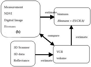
Fig.7 Flow of Estimation
Abstract
We measured the three-dimensional structural data of vegetation by using the three dimensional scanning system (TDS). And we investigate the use of these thre e-dimensional structural data of vegetation. For example, we estimate the dried weight of vegetation (biomass) using three-dimensional data. In August, 1999, we made observatio n in Mongolia grassland. And compare these data.
1. Introduction
It is very important to estimate the appearance of vegetation on the earth by using th e low resolution satellite. And for the estimation, it is need to measure the dried-weight (biomass) of plants.
In these years, we have made observations of Mongolian grassland. The methods of o bservation are Mobile measurement, BRDF measurement, Radio controlled helicopter mea surement, and Biomass measurement. In biomass measurement, we measure the grasses b y dried weight, grass height, and cubic volume. And last year, we appropriate the thre e-dimensional scanning system to acquire the three-dimensional structural data of plants(s ee Fig.1). Three-dimensional data of grassland vegetation is useful when measure these b iomass data. We develop the three dimensional scanning system and estimate bioma ss data.
In August, 1999, We made three-dimensional measurement in Mongolia grassland. And estimated the biomass using three-dimensional structural data of plants.
2. Three-Dimensional Scanning System
For the measurement, we use the three-dimensional scanning system(TDS-3100), produ ced by PULSTEC industry.
The Three dimensional scanning system consists of three parts, a camera, controller an d PC. The camera measures the distance from an object by using a laser scanning. The laser is controlled by the PC and Controller (see Fig.2). The system shown in Fig.1 is employed at the Mongolian grassland site to acquire three dimensional plant structure.
The characteristic points of this three-dimensional scanning system are follows:
- Non-destructive, non-touch measurement
- The wavelength of this laser is 680nm, and it is absorption band of vegetation.
- Small and easy to use.
3.1 Measurement Area
We made some areas at measurement area in grassland near the camp site(Fig.3). The camp site was set at the North part of Mandalgobi. Mandalgobi is seated at 250km far from Ulaancaatar (N25° 59^ 42" E106° 19' 40").
3.2 Measurement System
Measurement system is shown at Fig.4. Camera was set at the top of intelligent arm. And take the three-dimensional data as intelligent arm moving, The intelligent arm is produced by MITSUBISHI HEAVY INDUSTRY.
And setting this measurement system on the mobile car. (see Fig.5)
3.3 Measurement Method
We made some small areas(quadrat) in the measurement site. The size of one quadrat is 1m .1m, and we made 16 quadrats. At the each quadrat, we have three-dimensio nal measurement and biomass measurement. The three dimensional measurement was ma de from four different angle, and each measurement was held three times for each quadr at.
4. Estimation of Biomass
In biomass measurement(Fig.6), these data can be obtained.
- Reflectance data by multi spectrometer.
- Digital images by digital camera.
- Dried weight of plants by cutting grasses.
- Grass height
Three dimensional structural data of plants.
Reflectance of laser at the wavelength of 680nm.
Grass height h is measured from three dimensional data. Wavelength of 680nm is an ab sorption band of vegetation. So we can detect the plants by the reflectance data. As ass ume that the three dimensional data consists of a lot of voxels, the volume of vegetatio n and the vegetation coverage ratio (VCR) can be obtained. Because of these data, it is possible to estimate the biomass data from the three dimensional structural data of plant s.
5. Data Analysis
5.1 Preprocessing
Before the data analysis, It is need to preprocessing, such as enhancement, and pick up the plants from three-dimensional structural data. Before and after the enhancement imag e is shown at Fig. 8 and Fig.9.
5.2 Estimation of Vegetation Coverage Ratio(VCR)
After the preprocessing, we estimated the vegetation coverage ratio (VCR) of quadrat. VCR can be estimated by counting the points of plants(Fig. 10).
5.3 Estimation of Grass Height
From three-dimensional structural data, grass height data can be obtained. The compar ed graph of grass height data is shown in Fig.11. This grass height data was obtained b y man and three-dimensional data.
5.3 Estimation of Biomass
In biomass measurement, we cut grasses of four quadrat of three-dimensional scanning measurement area and measured the dried weight of these grasses. And also we estimate d the biomass using the three-dimensional structural data. The compared result of these t wo measurement is shown in Table.1.
| Quadrat | Dried Weight(g) | Esstimated Biomass |
| CA03 | 38.26 | 179.94 |
| CA06 | 34.78 | 156.38 |
| CA09 | 42.21 | 246.80 |
| CA0f | 50.92 | 373.39 |
In these result of analysis, we can see some relations between three-dimensional st ructural data and data obtained by biomass measurement.
But there is many difference between these data. One reason of this difference is m iss extraction of grass part from three-dimensional structural data.
6.Conclusion
We proposed the estimation of biomass data of grassland vegetation. But we didn’t co mpare the biomass data and three dimensional data completely.
It is needed to new algorithms to estimate the volumes of plants to more accuracy da ta.
And also three-dimensional structural data has many useful applications for other measurement. For example, we can estimate the BRDF by using three-dimensional s tructural data.
We have to propose the many using of three-dimensional structural data.
This work has been supported by CREST(Core Research for Evolutional Science and T echnology) in the research of PEPPERS(Project for Establishment of Plant Production E stimation using Remote Sensnig) of Japan Science and Technology Corporation (JST).
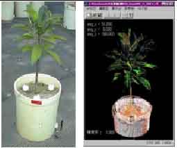 Fig1. Plant and 3D image |
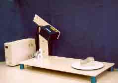 Fig.2 TDS-3100 |
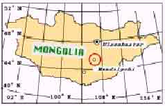 Fig.3 Measurement area |
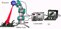 Fig.4 System |
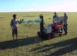 Fig.5 3D Scanner measurement |
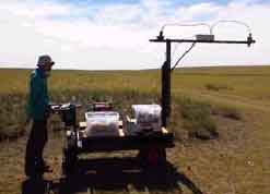 Fig.6 Biomass measurement |
Fig.7 Flow of Estimation
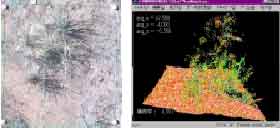 Fig.8 Before Preprocessing |
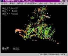 Fig.9 After Preprocessing |
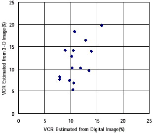 Fig.10 Estimated VCR |
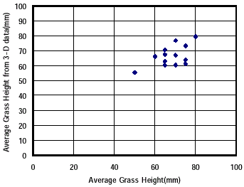 Fig.11 Average Grass Height |