| GISdevelopment.net ---> AARS ---> ACRS 1999 ---> Poster Session 2 |
Detection of Oyster Beds
Using Sar and Optical Sensor Data
Yuzo SUGA, Yoshinari OGURO
and Shoji TAKEUCHI
Hiroshima Institute of Technology,
2-1-1, Miyake, Saeki-ku, Hiroshima, 731-5193 JAPAN
Tel: (81)-82-921-2131 ext. (425) Fax: (81)-82-922-5204
E-Mail:http://www.gisdevelopment.net/aars/acrs/1999/ps2/ysuga@cc.it-hiroshima.ac.jp
Hiroshima Institute of Technology,
2-1-1, Miyake, Saeki-ku, Hiroshima, 731-5193 JAPAN
Tel: (81)-82-921-2131 ext. (425) Fax: (81)-82-922-5204
E-Mail:http://www.gisdevelopment.net/aars/acrs/1999/ps2/ysuga@cc.it-hiroshima.ac.jp
Keywords: RADARSAT, SPOT, Oyster Bed Detection,
Oyster Bed Counting.
Abstract:
The authors attempted to detect oyster beds in whole areas of Hiroshima Bay using high resolution satellite images like RADARSAT FINE-mode SAR image and SPOT HRV panchromatic image. An improved approach in which oyster beds are detected as a pixel-cluster in order to reduce noise effect was applied to both of RADARSAT-FINE and SPOT panchromatic images. The results of oyster bed detection and counting the numbers of oyster beds were slightly better for SPOT than for RADARSAT although the difference between the two was small. The result of this study suggested the promising application of both of RADARSAT and SPOT images for oyster bed monitoring in wide inner bay areas, especially for RADARSAT images due to it's all weather characteristics.
1. Introduction
Hiroshima Bay is one of the most suitable inner bay areas for cultured oyster farm and more than 70 percent of cultured oyster of Japan are produced in Hiroshima Bay. Oyster is sensitive to environmental conditions like water temperature and water quality and easily gets a severe damage by an environmental degradation, for example by a red tide. Therefore, it is quite important to keep the oyster farms in appropriate environmental conditions. Monitoring of exact locations and numbers of oyster beds is the basic issue for the management of oyster farms and now current high resolution satellite sensors are considered to have a great potential for the monitoring of oyster beds.
The location of oyster beds are possibly recognized with high resolution sensor data since the oyster bed is made by MOUSOU bamboo with the size of 10m in width and 20m in length. In addition, oyster beds are usually standing in a row with five or six carriages. The authors have attempted to detect oyster beds using Landsat TM image with 30m spatial resolution (Suga et al, 1985), RADARSAT-FINE SAR image with 6.25m resolution (Suga et al, 1997), and SPOT HRV panchromatic image with 10m resolution (Suga et al, 1999). In these studies, a pixel-wise thresholding approach was employed, however, this approach was quite sensitive to noise, especially to speckle noise in SAR images. In this report an improved method for detecting oyster beds with both of RADARSAT-FINE SAR and SPOT HRV panchromatic images is presented and the results of oyster bed detection and counting are evaluated by the comparison with the official report of oyster bed counting.
2. Test Data and Test Site
The RADARSAT FINE mode data were processed from signal data and the amplitude images with 6.25 meters resolution were generated. The SPOT HRV panchromatic data were resampled into the image data with 6.25 meters resolution same as that of RADARSAT images. The amplitude-stretched image of RADARSAT-FINE SAR (Feb. 1st, 1999) and the contrast-stretched image of SPOT HRV panchromatic (Jan. 31, 1999) around Hiroshima Bay are shown in Figure 1. The enlarged images around a test site of RADATSAT and that of SPOT HRV panchromatic are shown in Figure 2. The test site is located at the left upper part of original images shown in Figure 1 and the test site is indicated as bright rectangular area in Figure 2.
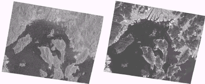
Fig.1. Amplitude-stretched image of RADARSAT-FINE SAR on Feb. 1st, 1999 (left) and contrast-stretched image of SPOT HRV panchromatic on Jan. 31, 1999 (right) around Hiroshima Bay.
(RADARSAT Image : © CSA & RADATSAT International 1999. SPOT Image: © CNES 1999.)
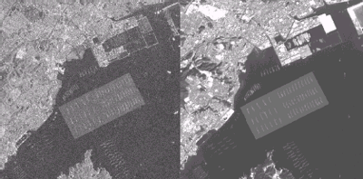
Fig.2. Enlarged images around a test site of RADARSAT-FINE SAR (left) and SPOT HRV panchromatic (right). The test site is indicated as bright rectangle in the center of the images.
3. Method for Oyster Bed Detection
We attempted to apply the smoothing window corresponding to one oyster bed and to detect an oyster bed as a cluster composed by several pixels by thresholding. The reason of this approach is that a pixel-wise thresholding approach is quite sensitive to noise and a cluster-based detection approach is expected to be more robust due to noise reduction effect by the smoothing window. For relatively high resolution image like RADARSAT-FINE and SPOT panchromatic images, it is possible to form a cluster for an oyster bed because the size of one oyster bed is larger than the pixel size of the images. Actual size of the bed is 10 by 20 meters, so for the image data with 6.25 meters pixel size 3 by 3 window is considered to be an appropriate size. However, for RADARSAT data bigger window sizes of 5 by 5, 7 by 7 and 11 by 11 were attempted and finally 7 by 7 window size was selected as the best one.
3.1 Oyster Bed Detection by RADARSAT Data
The oyster bed detection by RADARSAT data is performed by the following 10 steps:
Step 1: Making the speckle noise reduced image with 7 by 7 median filter.
Step 2: Making the amplitude-enhanced image with 7 by 7 maximizing filter.
Step 3: Making the amplitude-unenhanced image with 7 by 7 minimizing filter.
Step 4: Subtracting the amplitude-unenhanced image from the amplitude-enhanced image and adding an offset value with 100.
Step 5: Making the smoothing image with 7 by 7 average filtering.
Step 6: Making the binalized image with the threshold value TR.
TR is defined to 125 because it almost corresponds to the probability in which the half of the pixels in the window have the positive values (at least one) after subtraction (100+7*7/2=124.5).
Step 7: Filling the binalized image with 7 by 7 maximizing filter.
Step 8: Shrinking the binalized image with 7 by 7 median filter.
Step 9: Masking the resultant image by the land areas extracted from a map.
Step 10: Counting oyster beds.
In Step 10, the number of oyster beds is obtained by dividing the pixel count in the image of Step 9 by the number of pixels within the window on the assumption that the window size corresponds to the actual size of one oyster bed. However, in SAR images, the result was still affected by a speckle noise for smaller window size (3 by 3 or 5 by 5) and finally the window size with 7 by 7 was the best for RADARSAT-FINE images.
3.2 Oyster Bed Detection by SPOT HRV Panchromatic Data
The oyster bed extraction of SPOT HRV panchromatic data is performed by almost same procedure as RADARSAT, but with 3 by 3 window size, as follows:
Step 1: Making the amplitude-enhanced image with 3 by 3 maximizing filter.
Step 2: Making the amplitude-unenhanced image with 3 by 3 minimizing filter.
Step 3: Subtracting the ampritude-unenhanced image from the amplitude-enhanced image and adding an offset value with 100.
Step 4: Making the binalized image with the threshold value TS.
TS is defined to 105 by the same reason of RADARSAT (100+3*3/2=104.5).
Step 5: Filling the binalized image with 3 by 3 maximizing filter.
Step 6: Shrinking the binalized image with 3 by 3 minimizing filter.
Step 7: Masking the resultant image by the land areas extracted from a map.
Step 8: Counting oyster beds by the same method as RADARSAT.
4. Experimantal Result
The result of oyster bed detection by RADATSAT-FINE SAR (Feb. 1st, 1999) and that by SPOT HRV panchromatic (Jan. 31, 1999) around Hiroshima Bay are shown in Figure 3. And the results for the test site in Figure 2 are shown in Figure 4. The results for counting the number of oyster beds using RADARSAT and SPOT are shown in Table 1 together with the official announcement of the number of oyster beds on May 1997 .
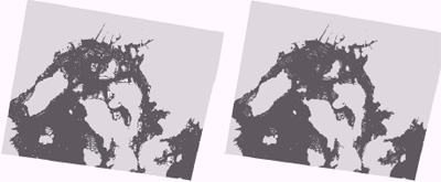
Fig.3 Results of oyster bed detection by RADARSAT(left) and SPOT(right) for the same areas as Figure 1.
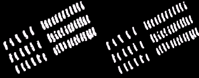
Fig.4. Results of oyster bed detection by RADARSAT (left) and SPOT (right) in the test site shown in Figure 2.
Table 1. Results for counting the number of oyster beds.
In Figure 3, it is found that the oyster beds are located near to the mouth of rivers and around small islands. Through the comparison of Figure 4 and Table 1, it can be seen that the result by SPOT is slightly better than that by RADARSAT. One reason is due to the smaller window size for SPOT than for RADARSAT. For RADARSAT, speckle noise problem in SAR image still can not be solved completely. However, the result by RADARSAT is quite similar to that by SPOT and the utilization of RADARSAT data for oyster beds monitoring is expected to be one of the practical application of RADARSAT data due to a merit of all weather characteristics of SAR data.
5. Concluding Remarks
Foregoing analyses lead to the promising application of both of RADARSAT-FINE SAR images and SPOT HRV panchromatic images for monitoring oyster beds in wide inner bay areas. The actual result for oyster bed detection and for counting the number of the beds was slightly better for SPOT than for RADARSAT. However, due to the all weather characteristics of RADARSAT SAR, RADARSAT-FINE mode data is much promising to be used for monitoring of oyster beds in wide inner bay areas. Further case studies in different seasons with the combination of other environmental information like water surface temperature and water quality should be continued to proceed oyster bed monitoring by remote sensing.
Acknowledgements
We thank to National Space Development Agency of Japan (NASDA) for the corporation in RADARSAT and SPOT data acquisition.
References
Abstract:
The authors attempted to detect oyster beds in whole areas of Hiroshima Bay using high resolution satellite images like RADARSAT FINE-mode SAR image and SPOT HRV panchromatic image. An improved approach in which oyster beds are detected as a pixel-cluster in order to reduce noise effect was applied to both of RADARSAT-FINE and SPOT panchromatic images. The results of oyster bed detection and counting the numbers of oyster beds were slightly better for SPOT than for RADARSAT although the difference between the two was small. The result of this study suggested the promising application of both of RADARSAT and SPOT images for oyster bed monitoring in wide inner bay areas, especially for RADARSAT images due to it's all weather characteristics.
1. Introduction
Hiroshima Bay is one of the most suitable inner bay areas for cultured oyster farm and more than 70 percent of cultured oyster of Japan are produced in Hiroshima Bay. Oyster is sensitive to environmental conditions like water temperature and water quality and easily gets a severe damage by an environmental degradation, for example by a red tide. Therefore, it is quite important to keep the oyster farms in appropriate environmental conditions. Monitoring of exact locations and numbers of oyster beds is the basic issue for the management of oyster farms and now current high resolution satellite sensors are considered to have a great potential for the monitoring of oyster beds.
The location of oyster beds are possibly recognized with high resolution sensor data since the oyster bed is made by MOUSOU bamboo with the size of 10m in width and 20m in length. In addition, oyster beds are usually standing in a row with five or six carriages. The authors have attempted to detect oyster beds using Landsat TM image with 30m spatial resolution (Suga et al, 1985), RADARSAT-FINE SAR image with 6.25m resolution (Suga et al, 1997), and SPOT HRV panchromatic image with 10m resolution (Suga et al, 1999). In these studies, a pixel-wise thresholding approach was employed, however, this approach was quite sensitive to noise, especially to speckle noise in SAR images. In this report an improved method for detecting oyster beds with both of RADARSAT-FINE SAR and SPOT HRV panchromatic images is presented and the results of oyster bed detection and counting are evaluated by the comparison with the official report of oyster bed counting.
2. Test Data and Test Site
The RADARSAT FINE mode data were processed from signal data and the amplitude images with 6.25 meters resolution were generated. The SPOT HRV panchromatic data were resampled into the image data with 6.25 meters resolution same as that of RADARSAT images. The amplitude-stretched image of RADARSAT-FINE SAR (Feb. 1st, 1999) and the contrast-stretched image of SPOT HRV panchromatic (Jan. 31, 1999) around Hiroshima Bay are shown in Figure 1. The enlarged images around a test site of RADATSAT and that of SPOT HRV panchromatic are shown in Figure 2. The test site is located at the left upper part of original images shown in Figure 1 and the test site is indicated as bright rectangular area in Figure 2.
Fig.1. Amplitude-stretched image of RADARSAT-FINE SAR on Feb. 1st, 1999 (left) and contrast-stretched image of SPOT HRV panchromatic on Jan. 31, 1999 (right) around Hiroshima Bay.
(RADARSAT Image : © CSA & RADATSAT International 1999. SPOT Image: © CNES 1999.)
Fig.2. Enlarged images around a test site of RADARSAT-FINE SAR (left) and SPOT HRV panchromatic (right). The test site is indicated as bright rectangle in the center of the images.
3. Method for Oyster Bed Detection
We attempted to apply the smoothing window corresponding to one oyster bed and to detect an oyster bed as a cluster composed by several pixels by thresholding. The reason of this approach is that a pixel-wise thresholding approach is quite sensitive to noise and a cluster-based detection approach is expected to be more robust due to noise reduction effect by the smoothing window. For relatively high resolution image like RADARSAT-FINE and SPOT panchromatic images, it is possible to form a cluster for an oyster bed because the size of one oyster bed is larger than the pixel size of the images. Actual size of the bed is 10 by 20 meters, so for the image data with 6.25 meters pixel size 3 by 3 window is considered to be an appropriate size. However, for RADARSAT data bigger window sizes of 5 by 5, 7 by 7 and 11 by 11 were attempted and finally 7 by 7 window size was selected as the best one.
3.1 Oyster Bed Detection by RADARSAT Data
The oyster bed detection by RADARSAT data is performed by the following 10 steps:
Step 1: Making the speckle noise reduced image with 7 by 7 median filter.
Step 2: Making the amplitude-enhanced image with 7 by 7 maximizing filter.
Step 3: Making the amplitude-unenhanced image with 7 by 7 minimizing filter.
Step 4: Subtracting the amplitude-unenhanced image from the amplitude-enhanced image and adding an offset value with 100.
Step 5: Making the smoothing image with 7 by 7 average filtering.
Step 6: Making the binalized image with the threshold value TR.
TR is defined to 125 because it almost corresponds to the probability in which the half of the pixels in the window have the positive values (at least one) after subtraction (100+7*7/2=124.5).
Step 7: Filling the binalized image with 7 by 7 maximizing filter.
Step 8: Shrinking the binalized image with 7 by 7 median filter.
Step 9: Masking the resultant image by the land areas extracted from a map.
Step 10: Counting oyster beds.
In Step 10, the number of oyster beds is obtained by dividing the pixel count in the image of Step 9 by the number of pixels within the window on the assumption that the window size corresponds to the actual size of one oyster bed. However, in SAR images, the result was still affected by a speckle noise for smaller window size (3 by 3 or 5 by 5) and finally the window size with 7 by 7 was the best for RADARSAT-FINE images.
3.2 Oyster Bed Detection by SPOT HRV Panchromatic Data
The oyster bed extraction of SPOT HRV panchromatic data is performed by almost same procedure as RADARSAT, but with 3 by 3 window size, as follows:
Step 1: Making the amplitude-enhanced image with 3 by 3 maximizing filter.
Step 2: Making the amplitude-unenhanced image with 3 by 3 minimizing filter.
Step 3: Subtracting the ampritude-unenhanced image from the amplitude-enhanced image and adding an offset value with 100.
Step 4: Making the binalized image with the threshold value TS.
TS is defined to 105 by the same reason of RADARSAT (100+3*3/2=104.5).
Step 5: Filling the binalized image with 3 by 3 maximizing filter.
Step 6: Shrinking the binalized image with 3 by 3 minimizing filter.
Step 7: Masking the resultant image by the land areas extracted from a map.
Step 8: Counting oyster beds by the same method as RADARSAT.
4. Experimantal Result
The result of oyster bed detection by RADATSAT-FINE SAR (Feb. 1st, 1999) and that by SPOT HRV panchromatic (Jan. 31, 1999) around Hiroshima Bay are shown in Figure 3. And the results for the test site in Figure 2 are shown in Figure 4. The results for counting the number of oyster beds using RADARSAT and SPOT are shown in Table 1 together with the official announcement of the number of oyster beds on May 1997 .
Fig.3 Results of oyster bed detection by RADARSAT(left) and SPOT(right) for the same areas as Figure 1.
Fig.4. Results of oyster bed detection by RADARSAT (left) and SPOT (right) in the test site shown in Figure 2.
Table 1. Results for counting the number of oyster beds.
| Area | Official Announcement (on May 1997) | RADARSAT-FINE SAR (Feb. 1st, 1999) | SPOT HRV Panchromatic (Jan. 31, 1999) |
| Test site | 333 | 322 | 329 |
| Whole Hiroshima Bay | 12972 | 12400 | 12911 |
In Figure 3, it is found that the oyster beds are located near to the mouth of rivers and around small islands. Through the comparison of Figure 4 and Table 1, it can be seen that the result by SPOT is slightly better than that by RADARSAT. One reason is due to the smaller window size for SPOT than for RADARSAT. For RADARSAT, speckle noise problem in SAR image still can not be solved completely. However, the result by RADARSAT is quite similar to that by SPOT and the utilization of RADARSAT data for oyster beds monitoring is expected to be one of the practical application of RADARSAT data due to a merit of all weather characteristics of SAR data.
5. Concluding Remarks
Foregoing analyses lead to the promising application of both of RADARSAT-FINE SAR images and SPOT HRV panchromatic images for monitoring oyster beds in wide inner bay areas. The actual result for oyster bed detection and for counting the number of the beds was slightly better for SPOT than for RADARSAT. However, due to the all weather characteristics of RADARSAT SAR, RADARSAT-FINE mode data is much promising to be used for monitoring of oyster beds in wide inner bay areas. Further case studies in different seasons with the combination of other environmental information like water surface temperature and water quality should be continued to proceed oyster bed monitoring by remote sensing.
Acknowledgements
We thank to National Space Development Agency of Japan (NASDA) for the corporation in RADARSAT and SPOT data acquisition.
References
- Suga Y. and S.Tanaka, 1985. An Oyster Cultivation in Hiroshima Bay Surveyed from LANDSAT TM Data (In Japanese), Proceedings of the 5th Japanese Conference on Remote Sensing, RSSJ(The Remote Sensing Society of Japan), 31, pp.119-120.
- Suga Y., K.Aoki, Y.Oguro, Y.Aratani, K.Takasaki and S.Tanaka, 1997. Detection of oyster farm beds in Hiroshima Bay using satellite data (In Japanese), Proceedings of the 23rd Japanese Conference on Remote Sensing, RSSJ(The Remote Sensing Society of Japan) A22, pp.59-60.
- Suga Y., Y.Oguro, S.Takeuchi and H.Ogawa, 1999. A trial for automatic detection of oyster beds in Hiroshima Bay with satellite data (In Japanese), Proceedings of the Joint Conference of JSPRS(Japan Society of Photogrammetry and Remote Sensing) and RSSJ(The Remote Sensing Society of Japan) B1-4, pp.215-216.