| GISdevelopment.net ---> AARS ---> ACRS 1999 ---> Poster Session 2 |
Estimation of forest biomass
density in Kalimantan Island using JERS-1 SAR data
Yumiko Wada and Ryosuke
Shibasaki
Center for Spatial Information Science and Institute of Industrial Science
The University of Tokyo
4-6-1 Komaba, Meguro-Ku, Tokyo 153-8505
Tel. (81)-3-5452-6412 Fax.(81)-3-5452-6414
E-mail: wada@skl.iis.u-tokyo.ac.jp
JAPAN
Center for Spatial Information Science and Institute of Industrial Science
The University of Tokyo
4-6-1 Komaba, Meguro-Ku, Tokyo 153-8505
Tel. (81)-3-5452-6412 Fax.(81)-3-5452-6414
E-mail: wada@skl.iis.u-tokyo.ac.jp
JAPAN
Keywords: SAR, forest biomass density,
backscatter, remote sensing, JERS-1
Abstract:
It is difficult to acquire optical remote sensing data in tropical regions because these area are generally covered with thick cloud. However SAR (Synthetic Aperture Radar) data is very useful to tropical regions so it can penetrate the clouds. Moreover response from vegetation using optical and near-infrared sensor is only reflectance of canopy top but microwave penetrate canopy top of vegetation and enables to conduct physical measurement. In this study, the authors apply estimation method forest biomass density at several sites in Kalimantan Island using JERS-1 SAR data.
Introduction
As tropical regions are generally covered with thick cloud all the year around, it is difficult to measure biomass by spaceborne optical instruments. In additions, Response of vegetation from optical sensor can observe chlorophyll in the canopy. Therefore it is difficult to distinction land cover after logging between the primary forest and young trees. On the other hand, SAR instrument can acquire the data in depend on the weather because of the properties of microwave.
Backscatter from vegetation of microwave have three types (Figure 1):
As L band microwave is penetrative (Iisaka, 1998) and very sensitive (Luckman, et al., 1997) to the forest, JERS-1 SAR L band sensor data will be used in this research. Therefore the objective of this study is to estimate forest biomass density at several sites in Kalimantan Island using JERS-1 SAR data.
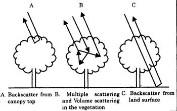
Figure 1. Variety of backscatter from vegetation (Iisaka, 1998)
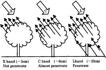
Figure 2. Wavelength and Rate of penetration to the canopy(Iisaka, 1998)
Study Area and Field Data
Bukit Soeharto Experimental forest (BSEF) of Mulawarman University (Hutan Pendidikan UNMUL) was rather damaged by large scale fire in East Kalimantan region in 1983 (Figure 3). In 1997 before the fire, lowland dipterocarp survived from the fire of 1983, has the average height of 45m. While secondary forest of macaranga which have the height of 20m distributed like a pitch. The secondary forest was formed macaranga mainly after the fire. In the experimental forest, macaranga was almost burn down by the natural dryness and the fire in 1997 to 1998.
Field data in this study includes following two kinds of biomass density data.
The locations of the field sites are following (Toma, 1999):
LDS: South latitude 0° 51' 44'', East longitude 177° 01' 66''
HDS: South latitude 0° 51' 68'', East longitude 177° 02' 46''
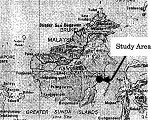
Figure 3. Bukit Soeharto Experimental forest in Kalimantan Island
Image Data
Spaceborne SAR can obtain following data: 1) C band on the ERS-1 and RADARSAT, 2) L band on the JERS-1 and 3) C-band, L band and X band on the SIR-C. JERS-1 SAR data was used for analyzing because the data occur multiple scattering and volume scattering and the data is easily to be acquired.
Since JERS-1 was launched by NASDA in 1992, it had obtained very large quantify of valuable data up to 1998. Image are used in our research path 91 and raw 302 which are summarized below.
Method
Backscatter model (Luckman, 1998) for the relationship between biomass density and microwave backscatter from vegetation can be described as:
s° (linear unit) = a-e -(bB+c) (1)
s° =calibrated normalized backscatter intensity (linear scale)
B=above-ground biomass density
a,b,c,=constants
s° (calibrated normalized backscatter intensity) is calculated by Normalized Radar Cross Section (NASDA, 1993).
Normalized Radar Cross Section (NRCS) of the target area in NASDA's standard product, whose product level is 2.1, is calculated from the equation (2). This simple equation is obtained by the analysis of the point target response which are included in the NASDA's standard area having several 2.4 and 2.0m trihedral corner reflectors, and active radar calibrators.
The dependency of the conversion factor on off nadir angle seems to a linear relationship with a small inclination. Because of the less confidence due to the smaller experimental points, the constant over all the off nadir angles has been obtained.
The processing parameters of the SAR processor has been improved , such as the antenna off nadir angle, AGC correction parameters. Then, the conversion parameters were listed in Table 1 as the function of the processed data.
N|RCS=20log10(I)+CF[dB] (2)
Table
1 Processing parameters of NASDA JERS-1 products (NASDA,
1993)
Equation (1) is based on water cloud model, which essentially represents the extinction of microwave radiation as it passes through a layer of vegetation made up of elements containing water. Parameters a is that model corresponds exactly to the saturation value of s 0 in linear units. Parameter b represents the gradient of the low biomass density part of the curve while parameters c is related to the residual backscatter at zero biomass.
Three JERS-1 coverage of study area was analyzed by equation and validation of estimated biomass density accuracy used by field data (Toma, 1999).
The result of this validation will be shown at poster session on ACRS conference (Some materials will also be distributed).
Acknowledgement
We would like to acknowledge to Mr. T. Toma (Japan International Cooperation Agency ), Assistant Professor S. Tsuyuki and Mr. T. Yamaguchi (Graduate School of Agriculture and Life Sciences, the University of Tokyo) who provide field data and digital data and give information for this study.
Reference
Abstract:
It is difficult to acquire optical remote sensing data in tropical regions because these area are generally covered with thick cloud. However SAR (Synthetic Aperture Radar) data is very useful to tropical regions so it can penetrate the clouds. Moreover response from vegetation using optical and near-infrared sensor is only reflectance of canopy top but microwave penetrate canopy top of vegetation and enables to conduct physical measurement. In this study, the authors apply estimation method forest biomass density at several sites in Kalimantan Island using JERS-1 SAR data.
Introduction
As tropical regions are generally covered with thick cloud all the year around, it is difficult to measure biomass by spaceborne optical instruments. In additions, Response of vegetation from optical sensor can observe chlorophyll in the canopy. Therefore it is difficult to distinction land cover after logging between the primary forest and young trees. On the other hand, SAR instrument can acquire the data in depend on the weather because of the properties of microwave.
Backscatter from vegetation of microwave have three types (Figure 1):
- Direct backscatter from canopy top.
- Multiple scattering and volume scattering in the vegetation.
- Direct backscatter from land surface.
As L band microwave is penetrative (Iisaka, 1998) and very sensitive (Luckman, et al., 1997) to the forest, JERS-1 SAR L band sensor data will be used in this research. Therefore the objective of this study is to estimate forest biomass density at several sites in Kalimantan Island using JERS-1 SAR data.
Figure 1. Variety of backscatter from vegetation (Iisaka, 1998)
Figure 2. Wavelength and Rate of penetration to the canopy(Iisaka, 1998)
Study Area and Field Data
Bukit Soeharto Experimental forest (BSEF) of Mulawarman University (Hutan Pendidikan UNMUL) was rather damaged by large scale fire in East Kalimantan region in 1983 (Figure 3). In 1997 before the fire, lowland dipterocarp survived from the fire of 1983, has the average height of 45m. While secondary forest of macaranga which have the height of 20m distributed like a pitch. The secondary forest was formed macaranga mainly after the fire. In the experimental forest, macaranga was almost burn down by the natural dryness and the fire in 1997 to 1998.
Field data in this study includes following two kinds of biomass density data.
- Lightly disturbed stand (LCD) biomass density
The canopy is almost covered with dipterocarp and it has been damaged very much before. - Heavily disturbed stand (HDS) biomass density
The locations of the field sites are following (Toma, 1999):
LDS: South latitude 0° 51' 44'', East longitude 177° 01' 66''
HDS: South latitude 0° 51' 68'', East longitude 177° 02' 46''
Figure 3. Bukit Soeharto Experimental forest in Kalimantan Island
Image Data
Spaceborne SAR can obtain following data: 1) C band on the ERS-1 and RADARSAT, 2) L band on the JERS-1 and 3) C-band, L band and X band on the SIR-C. JERS-1 SAR data was used for analyzing because the data occur multiple scattering and volume scattering and the data is easily to be acquired.
Since JERS-1 was launched by NASDA in 1992, it had obtained very large quantify of valuable data up to 1998. Image are used in our research path 91 and raw 302 which are summarized below.
| Image | Date | Path-Row | Data Level |
| 1 | 16/09/1993 | 91-302 | 2.1 |
| 2 | 28/04/1997 | 91-302 | 2.1 |
| 3 | 12/07/1998 | 91-302 | 0 |
Method
Backscatter model (Luckman, 1998) for the relationship between biomass density and microwave backscatter from vegetation can be described as:
s° (linear unit) = a-e -(bB+c) (1)
s° =calibrated normalized backscatter intensity (linear scale)
B=above-ground biomass density
a,b,c,=constants
s° (calibrated normalized backscatter intensity) is calculated by Normalized Radar Cross Section (NASDA, 1993).
Normalized Radar Cross Section (NRCS) of the target area in NASDA's standard product, whose product level is 2.1, is calculated from the equation (2). This simple equation is obtained by the analysis of the point target response which are included in the NASDA's standard area having several 2.4 and 2.0m trihedral corner reflectors, and active radar calibrators.
The dependency of the conversion factor on off nadir angle seems to a linear relationship with a small inclination. Because of the less confidence due to the smaller experimental points, the constant over all the off nadir angles has been obtained.
The processing parameters of the SAR processor has been improved , such as the antenna off nadir angle, AGC correction parameters. Then, the conversion parameters were listed in Table 1 as the function of the processed data.
N|RCS=20log10(I)+CF[dB] (2)
| Processed date | CF[dB] for JERS-1 SAR |
| By feb. 14, 1993 | -70.0 |
| After Feb. 15, 1993 | -68.5 |
| After Nov. 1, 1997 | -68.2 |
Equation (1) is based on water cloud model, which essentially represents the extinction of microwave radiation as it passes through a layer of vegetation made up of elements containing water. Parameters a is that model corresponds exactly to the saturation value of s 0 in linear units. Parameter b represents the gradient of the low biomass density part of the curve while parameters c is related to the residual backscatter at zero biomass.
Three JERS-1 coverage of study area was analyzed by equation and validation of estimated biomass density accuracy used by field data (Toma, 1999).
The result of this validation will be shown at poster session on ACRS conference (Some materials will also be distributed).
Acknowledgement
We would like to acknowledge to Mr. T. Toma (Japan International Cooperation Agency ), Assistant Professor S. Tsuyuki and Mr. T. Yamaguchi (Graduate School of Agriculture and Life Sciences, the University of Tokyo) who provide field data and digital data and give information for this study.
Reference
- Iisaka, J., 1998. Synthetic aperture radar image handbook. Asakura, Tokyo, pp 164-165. Japanese.
- Luckman, A. J., Kuplich, T.M., Yanasse, C.C.F., and Frery, A.C., 1997. A study of the Relationship between radar backscatter and regenerating forest biomass for spaceborne SAR instruments. Remote Sensing and Environment. 60, pp.1-13.
- Luckman, A., Baker, J., Honzak, M., and Lucas, R., 1998. Tropical forest biomass density estimation using JERS-1 SAR: Seasonal variation, confidence limit, and application to image mosaics. Remote Sensing and Environment. 63, pp. 126-139.
- NASDA, 1993. Usr's Guide to NASDA's SAR Products. HE-930014, Earth Observation Research Center, National Space Development Agency of Japan, pp. 10-12.
- Toma, T., 1998. Large-scale El Nino and Indonesia forest fire. Science Journal Kagaku. 68 (12), pp. 920-925. Japanese.
- Toma, T., Matius P., Hastaniah, Kiyono Y., Watanabe R. and Okimori Y. 1999.
- Dynamics of Burned Lowland Dipterocarp forest Stands in Bukit Soeharto, East Kalimantan. In GUHARDJA E., FATAWI M., Sutisna M., MORI T., OHTA S. (eds.) Rainforest Ecosystems of East Kalimantan : El Nino, Drought, Fire and Human Impacts. (in press)