| GISdevelopment.net ---> AARS ---> ACRS 1999 ---> Poster Session 1 |
The Pioneer Project Research
of Protection Forests Affairs Management System - An example on Ta-Chia
stream working cycle
Gwo-Jern Hwang1,
Yuh-Lurng Chung2, Wen-Fu Chen3
1 Assistant Engineer of, Taiwan Forest Bureau (TEB), Taipei, China Taipei
2 Associate Professor, National Pingtung Univ of Science and Technology,
Pingtung, China Taipei
3 Prof. of National Chung-Hsing Univ. Taichung. China Taipei
#2, Sec.1, Hang-Chow South Rd., China Taipei
E-mail: n1206153@ms29.hinet.net
Abstract 1 Assistant Engineer of, Taiwan Forest Bureau (TEB), Taipei, China Taipei
2 Associate Professor, National Pingtung Univ of Science and Technology,
Pingtung, China Taipei
3 Prof. of National Chung-Hsing Univ. Taichung. China Taipei
#2, Sec.1, Hang-Chow South Rd., China Taipei
E-mail: n1206153@ms29.hinet.net
The focus of our work in forest preservation is to protect Taiwan's forests from man-made catastrophes. Such include illegal cultivation, woodlands invasion, induced forest fires, and so on-affecting ecological balances and public safety. This study proposes a forest preservation management system that applies new technologies such as remote sensing, the geographic information system, and the global positioning system with central computer control. This management system can be applies to pre-forest damage monitoring work to obtain estimates of practicability. Bundling RS, GIS, and GPS into this system also adds the potential of tracking and aiding victims of forest disasters. Finally, the system is also designed to help operators better understand the ocmpositon of an existing forest and to provide decision-makers with reliable data for analysis and reference. With such data, a forest supervisor should be better equipped to make quick decisions and prevent a forest fire from spreading and causing greater loss.
1. Preface
The Geographic Information System (GIS) as established for Taiwan's forests incorporates an information database and system analysis functions. The system permits research of data related to forest area distribution and allows forestry management personnel timely access to data on conditions of forests under their supervision. GIS technology not only permits data, such as maps charting soil conditions, topography, elevation, and vegetation, to be entered and displayed in digital format, influencing factor data can be entered as well. Therefore, apart from the benefits of combining quantifiable data within an interactive, web-based format, the GIS technology adds to the equation the ability to overlay such data atop satellite imagery. Thus, users can even more rapidly update their data and thus more effectively monitor changes in the natural environment.
The comprehensive Forestry Protection Management System was established primarily to protect Taiwan's forests from man-induced hazards. Not only have the intrusions of man through unauthorized clearing; woodlands invasion, and induced forest fires caused irreparable damage to the ecology, they have also endangered the welfare of the nation. An effective data collection and application environment was established in order to help integrate current forestry-use charts with relevant data This new system will make data collection, updating, referencing, and analysis much easier as well as maintain strong momentum behind relevant forestry management work implementation. This research proposes a management system for forestry preservation which weds computer analysis functions with remote (RS) and global positioning system (GIS) technologies to form a powerful tool for forest disaster monitoring and control. The system also provides a regular analysis of data collected to supervisory personnel for their reference and action.
II. Research Materials and Methodology
1. Description of the Area Research
The Ta Chia Stream Commercial Zone is located in central Taiwan. Administratively, the zone straddles Hoping Hsiang in Taichung County, Jen Ai Hsiang in Nantou Country, and Tatung Hsiang in I-Lan Country. Geographically, the zone is located between 121o 07'50" and 121o26'42"east longitude and between 24o08'16" and 24o26'36" north latitude. The Nanhu North Mountain to the Nanhu South Mountain forma the eastern boarder through to the central mountain peaks to the eastern face of Hohuan Mountain. The southern extremity of the zone runs from Hohuan Mountain meets the Chushui Stream Commercial zone and then the Pahsien Commercial zone until reaching the The Chi Reservoir. The west is bounded first by the Tamu Mountain, followed by the Hsing Lung Mountain until reaching the main peak of Hsueh Mountain. The north follows the Ta His stream to the Taiping Mountain commercial zone until reaching Nanhu Mountain.
This Commercial zone is located above both the Ta Chia and Peikang streams and is bordered on theeat by the Wuhsi Commercial zone. This zone is met on the south by both the Chushui Stream and Puli Commercial zone. The western border touches on Pahsien Mountain and the Ta'an His Commercial zone. The north border runs along the Ta His Stream and is adjacent to the Taiping Mountain Commercial Zome. Commercial zone area particulars are listed below.
Sections: Forest divided into sections 1 through 85
Area: 48,754.39 hectares
Reserve Land: 12,124,878 square meters
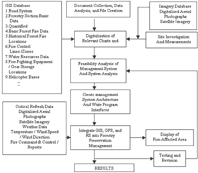
III. Research Methodology and Procedures
1. Research Methodology
- Documentary collection, data analysis, and file creation
- Digitalization of relevant charts and file creation
- Site Analysis and Measurement
- Feasibility analysis on management systems and systems analysis
- Create management system architecture and write interface programs
- Integrate GIS, GPS, and RS data into system
- Test and Revise
III. Result and Discussion
1. System Data Requirement
Bases on an analysis of system data requirements, we have determined that the following information / data should be incorporated into this system.
- Basic map data of Taiwan
- Basic map data of the Ta Chi Stream Commercial Zone
- Various laws, regulations, and administrative injunctions
- Satellite imagery
- Other data relevant to this project
Based on an analysis of system software function requirements, we have determined that the system will run the following software.
- Windows 95 or windows 98
- Ms Office 97
- Netscape Navigator, Gopher, and FTP
- Arc/View 3.0
- Notepad
System management setting commands include "Set Password", "Configure System Data Path", "Set System Name", "Configure Data Path", "Configure Name Path for DocumentT Manager", Configure word Path", "Configure WWW Path", "Configure Ftp Path", Configure Gopher Path, and "Open Configuration Window"
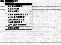
Diagram 1 : System Management Configuration Window
III. Analysis Function for System Overlays
The system selects a diagram level appropriate to user need or displays as a sequence all levels so to permit analysis of all diagram levels together. (Refer to diagram 2)
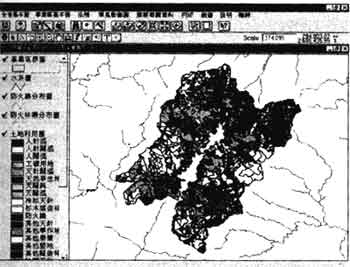
Diagram 2: System Overlay Analysis Function
IV. System database management and statistical and analytical functions
The user may initiate data attribute updates, add new fields or records, reconfigure display format, run basic statistical work, link to other databases, and run condition based searches in any defined area within the database. (Refer to diagram 3)
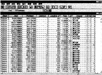
Diagram 3: System Database Management and Statistical and Analytical Functions
IV. Conclusions :
- Utilize a computer management system to perform systematic analysis of forestry preservation management and thus raise administrative effectiveness.
- Obtain information critical to administrative and management work by systematizing forestry preservation work processes and linking such with the powerful potential of GIS technology.
- Once links and interfaces between databases and the GIS are complete, data display and search will not only be able to execute across all databases, the system will provide for operators an exceptionally user-friendly environment.
- With the completion of the first stage of plans for this system, the concept can be introduced and implemented in other forestry preservation areas. The gradual acceptance and implementation of this system on a nationwide scale will help achieve stated national objectives of system-wise computerization, digitalization, efficiency, and convenient citizen-access.
- Lucas, H.C. 1994 Information systems concepts for management, New York: Mitchell Mcgraw-Hill.
- Reynolds, G.W. 1992 Information systems for managers, St, Paul: West Pub. Co.
- Laudon, K.C. Traver, C.G. and Laudon, J.P. 1995 Information technology: cpmcepts and issuesDANVERS, MA: Boyd & Fraser.
- ESRI 1996 Using Arc View GIS, 350 pp.
- ESRI 1996 Using Avenue, 260 pp.