| GISdevelopment.net ---> AARS ---> ACRS 1999 ---> Poster Session 1 |
Digital Orthoimage Generation
from Large-Scale Aerial Photography
Jiann - Yeou
Rau
Scientific Research Assistant,
Center for Space and Remote Sensing Research (CSRSR)
Ph. D Student, Department of Civil Engineering
Liang - Chien Chen
Professor, Department of Civil Engineering & Csrsr
CSRSR, National Central University, Chung-Li
Tel: (886)-3-4227151 Ext. 7651 or 7622 Fax: (886)-3-425535
E-mail: jyrau@csrsr.ncu.edu.tw, tcchen@csrsr.ncu.edu.tw
China Taipei
Key Words Orthoimage, Back Projection,
Digital Building Model.Scientific Research Assistant,
Center for Space and Remote Sensing Research (CSRSR)
Ph. D Student, Department of Civil Engineering
Liang - Chien Chen
Professor, Department of Civil Engineering & Csrsr
CSRSR, National Central University, Chung-Li
Tel: (886)-3-4227151 Ext. 7651 or 7622 Fax: (886)-3-425535
E-mail: jyrau@csrsr.ncu.edu.tw, tcchen@csrsr.ncu.edu.tw
China Taipei
Abstract
Orthographically rectified image maps are getting important due to its low cost and fast production. The major difficulty of generating orthoimage is the large displacement and hidden effects appeared in the original images when large-scale aerial photos are considered. We present here a new scheme to compensate the occluded information for an image from its counterpart image when digital building model and orientation parameters are available. Major components of the scheme include (1) bottom-up back projection (2) detection of hidden areas and determination of the weighing for stitching, and (3) gray value fill-in for hidden areas in conjunction with weighting average smoothing around the borders of hidden areas. Experimental results indicate that the proposed scheme may achieve accuracy better than one pixel.
1. Introduction
While the GIS applications are still booming, orthographically rectified image maps are getting important due to its low cost and fast production. There is a huge demand for more versatile and accurate map information. Digital orthoimages provide multi-scale, multi-temporal, and multi-spectral properties thus production of the images becomes a main trend in the field of GIS and photogrammetry [Hofmann, et al., 1984]. The major difficulty of generating orthoimage is the large displacement and hidden effects appeared in the original images when large-scale aerial photos are considered. The relief displacement of man-made building causes information loss and photo interpretation error.
Mayer [1999] and Shufelt ]1999] surveyed the state-of-the-art automatic building extraction techniques. They concluded that a fully automatic system is still a long way to go. While on the
Mayer [1999] and shufelt [1999] surveyed the state-of-the art automatic building extraction techniques. They concluded that a fully automatic system is still a long way to go. While on the other hand, the semi-automatic approaches are becoming important [Sahar & Krupnik, 1999]. It is not the purpose of this paper to emphasize the generation of digital building model (DBM). However, DBM is needed in the generation of orthoimage using large-scale aerial photography.
This paper presents a technique to use two (or more) images to generate the orthoimage by gray value compensation for the occlusion area. Provided that a raster-based DBM is available, we utilize the concept of Z-buffer to detect hidden area caused by man-made buildings. IN the processing of orthoimage generation for a master image, the gray values in the occluded area are filled-in from its counterpart image, i.e.,a slave image. In the mean time, a weighing average technique is performed to generate seamless mosaicking.
The flowchart of the proposed scheme is shown in figure 1. Major components of the scheme include (1) bottom-up back projection using DTM, as the dark blocks in figure 1, (2) detection of hidden areas using DBM and the determination of weighting for stitching, as the gray blocks in figure 1, and (3) gray value fill-in with smoothing around the hidden areas, as the remaining blocks in figure 1.
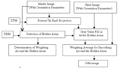
Figure 1. Flowchart of the proposed scheme
We describe the technique for detecting the hidden areas in the next section. In section 3, we show how to generate the orthoimage without false boundary effect. Accuracy analysis and the similarity assessment for validating the proposed scheme are included in section 4. Finally, concluding remarks are provided in the last section.
2. Detection for Hidden Area
Before generating orthoimage we need to detect the ground location of hidden areas caused by building in a master image. We, accordingly, can trace the ground location in a slave image to retrieve the gray value information for compensation.
The hidden areas are detected by the concept of Z-buffer. The Z-buffer is a matrix, in the image coordinate system, which stores the distance from the camera location to the objects. As from figure 2 we see that point X and Y on the ground are projected on the same position at the image space. Object point Y with shorter distance means that it could be view by the camera and the other point x is in the hidden area.
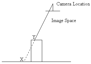
Figure 2 Hidden Area Detection
In the proposed algorithm, we calculate the projected position pixel by pixel along the DBM to the image space using the collinearity condition equation and store their distances into a matrix. Whenever two points are located at a same cell, the distance values are compared to each other. The shortest distance is remained, while the pixel with longer distance is marked as a hidden pixel and saved in another index map in the ground coordinate system.
Because the collinearity condition equation is a non-linear transformation, tracing from an equal grid DBM to the image space will create isolated points of lines. A post processing on the index map is necessary. In which, a median filter is included to remove the isolated points and lines.
3. Generating of Orthoimage
A traditional bottom-up back projection to generate orthoimage is utilized [Chen & Rau, 1993] [Chen & Lee, 1993]. Using the index map created in the previous section we have detected the hidden areas. Thus the gray value information could be recovered from a slave image. Considering to the different illumination condition, the distribution of gray value for the two images, the master and the slave image, may varied. Thus, directly fill in gray value from slave image will create false boundary around the hidden areas. In order to cope with this problem, a smoothing technique using weighing average approach is applied to reduce the incongruity.
We create a buffer zone along the borders of each hidden area. Within the buffer zone, the gray value is calculated using weighting average considering the master and the image. The weighting factor is determined by the width of the buffer zone that is created using a mathematical morphology operation called DILATION.
Figure 3 shows an example of an index map after dilation processing. In which the continuous change of weighting factor is shown surrounding the hidden areas. According to the proposed scheme, an example of orthoimage is provided in figure 4. For the sake of comparison, a result of bottom-up back projection for a master image is provided in figure 5. It is noticed that, in figure 5 a building is slant to the left and blocks a road, because the camera center is to its right hand side. However, as shown in figure 4.the road recovered using the proposed scheme. Be aware that there is no gray value discontinuity around the borders of hidden areas.
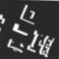
Figure 3, An example of index map.
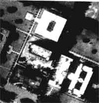
Figure 4, An orthoimage generated by the proposed scheme.
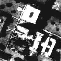
Figure 5, A back-projection example.
4. Case Study
A streopair of aerial photography covering National Central University (NCU) is used for case studying. The photo scale of the stereopair is 1:9,000 and the base-height-ratio is 0.55. Both photos were scanned at 12.5 mm to achieve a nominal ground resolution of 11.25cm. The DBM for orthoimage generation is shown in figure 6. A final orthoimage is shown in figure 7, which was resampled at 50cm ground resolution with 1792 x 1792 pixels. In which, the relief displacements of building were corrected according to a given DBM
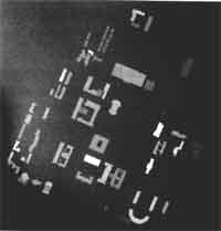
Figure 6: DBM for NCU Campus
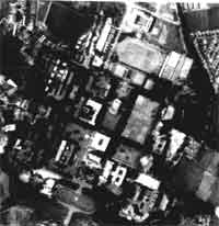
Figure 7: The generated orthoimages
A simulated bird-view image for NCU campus is shown in figure 8.a picture taken from a helicopter, i.e. figure 9, was used for visual comparison. Because the test image were acquired 5year before the helicopter one , some buildings do not appear in the simultedi image. Except for that difference, we got a high reliable orthoimage.
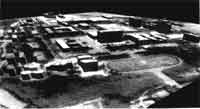
Figure 8: Simulated bird-view image
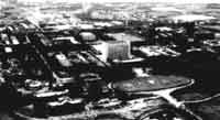
Figure 9: A picture taken from helicopter
Finally, for error analysis, we used leica SD2000 analytic stereo plotter to digitize 170 corners from 48 major buildings as a reference date set. Under the condition with 107cm of altitude error, we got planimetric error of 45cm as shows in table . that is to say, the orthoimage we generated achieve accuracy better than one pixel comparing to 50cm ground pixel spacing.
| X | Y | Z | |
| Standard error | 45.5 | 45.2 | 107.2 |
| Mean | 37.5 | 21.8 | -34.5 |
5. Conclusion
In this paper we present a new scheme to generate orthoimage provided that a raster-based DBM is available. The proposed scheme composes (1) correction of the relief displacement for buildings, (2) recovering of the information within the hidden areas, and (3) stitching the filled-in gray value with the master image data to reduce the discontinuity effect. From the visual comparison for similarity assessment we got a high reliable result. In the error analysis, we manually digitized 170 corners from 48 major building in the study area for validation. An accuracy of 45cm planimetric error was achieved. Comparing to 50cm of pixel spacing, the accuracy for the orthoimage is better than one pixel.
6. Reference
- Sahar, L., and Krupnik, A. (1999). "Semiautomatic Extraction of Building Outlines from Large-Scale Aerial Images." PERS, Vol. 65, No. 4, pp. 459-465.
- Shufelt. J.A. (1999). "Performance Evaluation and Analysis of Monocular Building Extraction from Aerial Imagery." IEEE Trans. On PAMI, Vol. 21, No. 4, pp. 311-326.
- Mayer, H. (1999). "Automatic Object Extraction from Aerial Imagery-A Survey Focusing on Buildings." CVIU, Vol. 74, No. 2, pp. 138-149.
- Chen, L.C. and Rau, J.Y. (1993). "A Unified Solution for Digital Terrain Model and Orthoimage Generation from SPOT Stereopairs." IEEE Trans. on Geoscience and Remote Sensing, Vol. 31, No. 6, pp. 1243-1252.
- Chen, L.C. and Lee, L.H. (1993), "Rigorous Generation of Digital Orthophotos from Spot Images." PERS, Vol. 59, pp. 655-6611.
- Hofmann, O., Ebner, H., and Nave, P. (1984). "DPS - A Digital Photogrammetric System for Producing Digital Elevation Models and Orthophotos by Means of Linear-Array Scanner Imagery." PERS, Vol. 50, pp. 1135-1142.