| GISdevelopment.net ---> AARS ---> ACRS 1999 ---> Geology |
Application of RS and GIS in
natural disaster survey: a case study of mountainous landslide caused by
the herb typhoon
Chinsu Lin *, Yeong-Kuan Chen **, Shoei-Jyi Wu
***
* Assistant Professor, Dept. of Forestry
National Chiayi Institute of Technology
300 University Road, Chiayi (600)
Tel: (886)-5-2717476 Fax: (886)-5-2788724
E-mail: chinsu@rice.cit.edu.tw
China Taipe
** Professor, Dept. of Forestry
National Taiwan University
1, Sec. 4, Roosevelt Road, Taipei (106)
Tel: (886)-2-23639799 Fax: (886)-2-23639799
E-mail: ykchen@ccms.ntu.edu.tw
China Taipe
*** Researcher, Council of Agriculture
Executive Yuan, Republic of China
37 Nanhai Road, Taipei (100)
Tel: (886)-2-23124081 Fax: (886)-2-23125857
E-mail: sjwu@mail.coa.gov.tw
China Taipe
Keywords: Natural Disaster, Landslide, Herb
Typhoon, Remote Sensing, GIS* Assistant Professor, Dept. of Forestry
National Chiayi Institute of Technology
300 University Road, Chiayi (600)
Tel: (886)-5-2717476 Fax: (886)-5-2788724
E-mail: chinsu@rice.cit.edu.tw
China Taipe
** Professor, Dept. of Forestry
National Taiwan University
1, Sec. 4, Roosevelt Road, Taipei (106)
Tel: (886)-2-23639799 Fax: (886)-2-23639799
E-mail: ykchen@ccms.ntu.edu.tw
China Taipe
*** Researcher, Council of Agriculture
Executive Yuan, Republic of China
37 Nanhai Road, Taipei (100)
Tel: (886)-2-23124081 Fax: (886)-2-23125857
E-mail: sjwu@mail.coa.gov.tw
China Taipe
Abstract
Steep terrain relief and unstable river system in Taiwan make landslides and massflows happen frequently when a storm visits there in the summer. Such natural disasters usually cause huge property damages and loss of human lives. Understanding the location and influences of natural disaster is important and helpful for post-disaster financial support and environmental restoration. It could also be a good reference for natural disaster prevention and land management planning. The Herb typhoon visited the middle-south part of Taiwan on July 31, 1996, and resulted in serious landslides and massflows. After that event, the eroded mass settled down and became barelands. In this study, SPOT XS images of new barelands and their spatial pattern in Chiayi slopeland area, middle-south area of Taiwan was analyzed. The results showed that area of new barelands from June to December 1996 was 9726.72 ha which were about 8.69 % of the whole area. New bareland area that happened at each site was more than 1000 ha, and Alishan was the largest one. Twenty-nine percentage of the new bareland patches, or 2836.77 ha, were nearby rivers or roads, in which 32 % (900.63 ha) were located on the site where the rivers and roads pass through. This phenomenon demonstrated the importance and necessity of conservation for the land nearby the stream bank and road. In view of land slopes, most of the new barelands were distributed on slopeland under 35 degree. The percentage of both original and newly-happened barelands are decreasing from the 1st slope class (< 5° ) down to the 4th slope class (26° – 35° ) and then increasing, and just look like a parabolic form. The percentage of newly occurred barelands in developing cover types, e.g. orchard, areca, and tea field etc. is almost 6.5 to 10.5 times larger than the one in the forested area. It proved that the storm-damage resistance of forest is the best in all vegetative cover types.
Introduction
The Herb typhoon visited the middle-south part of Taiwan on July 31, 1996. He brought a heavy rain and resulted in serious landslides and massflows in mountainous area (TFB, 1998; CWG, 1999). Huge properties and lots of human lives were damaged and lost in that disaster. This study aimed to understand the landslide distribution caused by the storm. Landslide is a process of mass movement. After that process, the eroded masses settled down and became barelands. According to such concept, the new barelands occurring after the Herb typhoon were surveyed by techniques of remote sensing, and the spatial patterns of those barelands were also analyzed by geographic information systems in this study.
Materials and Methods
The mountainous area of Chiayi County, the middle-south part of Taiwan, was chosen as a study site. This site has an area of about 112000 ha and well developed streams and road networks. The terrain relief is steep in its eastern part. Average annual rainfall was more than 4000 mm (CCG, 1995; Liou et al., 1998).
Satellite Images and Auxiliary Data
Four SPOT XS images (list as table 1) were used to analyze the land cover of study site. Two of them were scanned before Herb visited day (July 31, 1996) and the others scanned after that day. Land cover mosaic of per pair image was produced since the study site is located on two adjacent paths and each path contains only partial area of it. Auxiliary data, such as roads, streams, cover types in forestland, and digital terrain model were generated from some released maps. These maps were digital road network map (IOT, 1998), topographic map, forest resources survey map (TFB, 1995) and photo base map.
Table 1. Scanning parameters of SPOT images used in this study *
|
| |||||
| Image code ** | Scanned date | Azimuth | Elevation | Incidence | Pixel spacing |
|
| |||||
| T1R | 1996/6/1 | 161.891° | 41.358° | 27.547° | 12.5 m × 12.5m |
| T1L | 1996/6/2 | 155.652° | 39.730° | -12.719° | 12.5 m × 12.5m |
| T2R | 1996/12/21 | 155.646° | 39.191° | -22.313° | 12.5 m × 12.5m |
| T2L | 1997/11/20 | 157.552° | 44.134° | -12.718° | 12.5 m × 12.5m |
|
| |||||
| *Geocoded level 10 images were supplied by the NCRS,
Taoyuan ** Image code T1 andT2 represents the images scanned before and after the Herb typhoon; R and L stand for right and left part of the study site | |||||
Bareland Detection Algorithm ¾ Maximum Likelihood Method
A supervised classification method, maximum likelihood classifier (ERDAS, 1997; Schowengerdt, 1997), was applied for land cover extraction, in which multiple signatures of bareland, vegetation, and water classes were selected according to the transformed divergence (TD) between classes. TD threshold set in signature selection was 1900 (Jensen, 1986). Classification accuracy was assessed with two indices, the overall accuracy and kappa coefficient of agreement (Hudson and Ramm, 1987).
Matrix Analysis
This study used matrix analysis (Lin and Chiao, 1997) to derive the change map of land cover in the study site nearby the Herb typhoon. In Eq. (1), the parameter N is the number of classes, i.e. 3, in T1 and T2 thematic maps, the parameter a and b represents their class code, and 0 stands for the background.
Mat_change = Either 0 IF (a IS 0 OR b IS 0) [a + N(b-1)] OTHERWISE (1)
Spatial Analysis
The spatial pattern of newly happened barelands (patches) after the Herb typhoon was analyzed with GIS spatial analysis techniques. Figure 1 shows the conceptual diagram of such spatial analysis. Eq. (2) described the set logic of overlay analysis, where A set represents patches {N} in a polygon feature of forest cover type or slope coverage {P}. Eq. (3) determined the patches {N} intersected with a line feature of stream or road coverage {L}, B set; while the patches connected to the preexistent bareland patches {E} in T1 map (states before the Herb visited day), C set, were determined by Eq. (4).
a.Overlay analysis
A={x | x={N Ç P}} (2)
b. Intersecting analysis
B={x | x={N É L}} (3)
c. Connectivity analysis
C={x | x={Distance(E,N)=0}} (4)
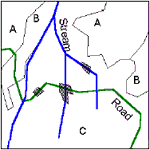
Figure 1. Conceptual Diagram of Spatial Analysis.
Results and Discussion
Accuracy Assessment of Classified Thematic Map
Transformed divergence among the bareland, vegetation, and water showed that these three classes could be distinguished very well. The overall accuracy of T1 and T2 thematic maps were greater than 95 percent, and their kappa coefficient of agreement were greater than 88 percent. Detail assessment of classification accuracy refers to table 2.
Table 2. Confusion table for T1 and T2 classified thematic map
|
| ||||||||||
| T1 ** | T2 *** | |||||||||
|
|
| |||||||||
| Class* | Ba | Veg | Wa | Sum | Class1) | Ba | Veg | Wa | Sum | |
| Ba | 536 | 36 | 135 | 707 | Ba | 757 | 104 | 44 | 905 | |
| Veg | 265 | 5208 | 0 | 5473 | Veg | 44 | 5140 | 0 | 5184 | |
| Wa | 0 | 0 | 1765 | 1765 | Wa | 0 | 0 | 1856 | 1856 | |
|
|
| |||||||||
| Sum | 801 | 5244 | 1900 | 7945 | Sum | 801 | 5244 | 1900 | 7945 | |
|
| ||||||||||
| * Symbols Ba, Veg, and
Wa stand for the bare land, vegetation, and water class
respectively. ** Classified map T1 stands for the state before the Herb typhoon, which has a 95.57% and 88.64% of overall accuracy and kappa coefficient of agreement respectively. *** Classified map T2 stands for the state after the Herb typhoon, which has a 97.58% and 95.19% of overall accuracy and kappa coefficient of agreement respectively. | ||||||||||
Change of Land Covers Nearby the Herb Typhoon
Change of the land covers, bare land, water, and vegetation, nearby the Herb typhoon was derived from T1 and T2 thematic map. Figure 2 demonstrates the spatial distributions of nine classes (paths) among three major land covers of the study site. Area (pixel counts) of each class was also calculated and described in detail in Table 3. It showed that the site has 7,165,707 pixels (111,964 ha), in which the bare land and water has increased 3405 ha and 861 ha, while the vegetation decreased 4266 ha between T1 and T2.
Change Map of Land Cover of Chiayi Slope Land Area nearby Herb Typhoon.
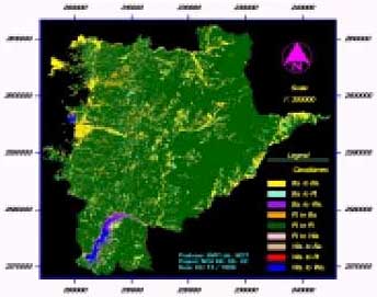
Figure 2. Change of Land Covers of the Site nearby the Herb Typhoon.
Table 3. Area statistics for the change of land covers nearby the Herb typhoon *
|
| |||||
| To the state after Herb (T2) | |||||
|
| |||||
| Bare land | Vegetation | Water | Sum | ||
|
| |||||
| From the state before Herb (T1) |
Bare land | 365498 | 359274 | 46765 | 771537 |
| Vegetation | 623700 | 5712185 | 8619 | 6344504 | |
| Water | 260 | 27 | 49379 | 49666 | |
|
| |||||
| Sum | 989458 | 6071486 | 104763 | 7165707 | |
|
| |||||
| * Counting unit is pixels, and a pixel stands for an area of 12.5 12.5 square meter. | |||||
Relations among the New Bareland and Stream and Road System
There was a linearly distributed spatial pattern for the newly happened bareland patches in T2 thematic map after the Herb typhoon, especially alone the streams and roads. Figure 3 has demonstrated this spatial pattern. By the area statistics view, 2836.77 ha, i.e. 29 % of new bareland patches happened closed to the streams and roads, in which 900.63 ha were located on the site where the streams and roads pass through. This phenomenon demonstrated the importance and necessity of conservation for the land nearby the stream bank and road.
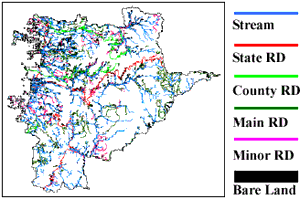
Figure 3. New Bareland Patches nearby the Stream or Road.
Table 4. Area statistics of new bareland which connected to and/or intersected with the stream or road
|
| |||||
| Stream | State road | County road | the Other road | Net area | |
|
| |||||
| Stream | 2510.31 | (110.23) * | (121.70) | (668.70) | 1609.68 |
| State road | (110.23) | 306.91 | (0) | (24.56) | 172.12 |
| County road | (121.70) | (0) | 352.19 | (70.80) | 159.69 |
| the Other road | (668.70) | (24.56) | (70.80) | 1659.34 | 895.28 |
| Net area ** | 1609.68 | 172.12 | 159.69 | 895.28 | 2836.77 |
|
| |||||
| * Area includes in parentheses are the duplicated ones in each entry. ** Net area is derived by subtract the parenthesized areas from the one in diagonal entry in that column. Areas were presented in ha. | |||||
Relations between the New Bareland and Land Use in Forest Area
There are six types of vegetation in the national forest area of this study site. The area of each vegetative type is tree 63004.11 ha, grass 984.41 ha, tea field 79.34 ha, areca field 722.05 ha, farm 606.33 ha, and orchard 182.95 ha in 1988, while bareland occupied some area in the summer of 1996. Analyzed results (Figure 4) showed that the largest and smallest percentage occupied by bareland in each vegetative type is tree (2 %) and grass (18%). After Herb typhoon event, newly-happened bareland percentage (NP) in tree area was 6%, which was also the smallest one in the six vegetative types. It revealed that NP in grass, farm, orchard, and tea or areca field was 6.5 to 10.5 times larger than NP in tree area. Results also showed a spatial dependence existed in NP distribution because there was 77 percent of NP closed to the preexistent bareland patches.
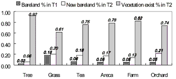
Figure 4. Bareland Occupied and Vegetation Exist Percentage of Six Vegetation Type in Forest Area.
Relations between the New Bareland and Terrain Slope
In view of terrain slope, NP was mainly distributed in the positions under 35 degrees of slope. Figure 5 shows the area percentage of bareland of each class of slopes. The codes A, B, and C in legend denote the total area of the site, bareland in T1, and NP in T2. The tendencies of preexisted bareland in T1 (blue curve), NP in T2 (red curve), and total bareland in T2 (green curve) are very similar. All curves presented a parabolic form, and bending at the 4 th slope class, i.e. 26~35 degree, in which a higher bareland percentage existed far from that point was revealed. The natural disaster or illegal farming in slopeland might cause this phenomenon.
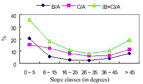
Figure 5. Variations of the Area Percentage of Bareland in Six Classes of the Slopeland.
Conclusion
Spatial pattern of newly happened bareland patches revealed that the importance and necessity of conservation for the land nearby the riverbank and road. Although the bareland area in tree area is larger than the other five vegetative types, but in view of bareland occupied percentage, the disaster resistance of tree is better than grass, orchard, farm, tea and areca field. There is a spatial dependence in related to existing bareland. It could be a reference for forest manager in management planning. For sustainable management, manager should pay intention to sites with a lower slope to prevent an illegal farming.
References
- CCG, 1995. No. 45, Annual Statistical Overview of Chiayi County Government (CCG).
- CWB, 1999. Knows the Typhoon in web site “http:// www.cwb.gov.tw/index.html". Central Weather Bureau
- ERDAS Inc., 1997. ERDAS Field Guide, 4 TH edition. Atlanta, GA. pp.343-353.
- Hudson, W.D. and C.W. Ramm, 1987. Correct formulation of the kappa coefficient of agreement. Photogrammetric Engineering and Remote Sensing 3(4): 421-422.
- IOT, 1998. Digital Map of 1/25000 Road Network of Taiwan. Ver. 1.0, Institute of Transportation, Ministry of Transportation and Communications, 47 p.
- Jensen, J.R., 1986. Introductory Digital Image Processing. Prentice-Hall, New York, pp.177-233.
- Lin, C. and K.M. Chiao, 1997. Study on the change detection of ecological environment by using the remotely sensed data -an illustration of Tainan district. Journal of Photogrammetry and Remote Sensing 2(3): 37-76.
- Liou, J.C., Lin, C. and G.Y. Chen, 1998. The research on bare area of six districts in Chiayi slope land. Journal of Chinese Soil and Water Conservation 29(2): 97-104.
- Schowengerdt, R.A., 1997. Remote Sensing: Models and Methods for Image Processing. 2 ND edition. Academic Press, San Diego, pp.389-409.
- TFB, 1995. The Third Forest Resources and Land Use Inventory in Taiwan. Taiwan Forest Bureau, 258 p
- TFB, 1998. Law Handbook for Forest Management. Taiwan Forest Bureau, pp.529-538.