| GISdevelopment.net ---> AARS ---> ACRS 1999 ---> Oceanography/Coastal Zone |
Ocean color remote sensing by
Sea WiFS in China
Pan Delu Haung Haiqing Mao
Tingming and Mao Zhehau
Second Institute of Oceanography, SOA,Hangzhou, PRC 310012
E-mail: pandelu@mail.hz.zj.cn
Second Institute of Oceanography, SOA,Hangzhou, PRC 310012
E-mail: pandelu@mail.hz.zj.cn
Abstract
The special ocean color satellite, SeaStar, was successfully launched in August, 1997. The Sea-Viewing wide Field-of-View Sensor, SeaWiFS, has brought to oceanographers a welcomed and improved renewal of the ocean color remote sensing data.
The Hangzhou station of SIO, SOA (Second institute of Oceanography, Sate Oceanic Administrations) is a SeaWiFS scientific research station which has authorized by NASA USA, to free receive SeaWiFS data. Since September 16, 1997, the station has being normally received and achieved data. The series of SeaWiFS data has been applied to measuring the concentration of chlorophyll, suspended material and to study detecting red tide and dynamics of the coastal water in China Sea.
In the paper, first SeaWiFS technique system in China is introduced. Then, the local algorithm of SeaWiFS atmospheric correction and the calculation of chlorophyll and suspended material etc. are discussed. Finally, some good results from the experiment of SeaWiFS application are presented in the paper, which shows the SeaWiFS potentiality in the environment detection of coastal water.
Introduction
Since the end of 1970's, measurements from satellite had demonstrated that ocean color remote sensing is a powerful tool for understanding oceanic biological and physical process. In 1978, The Nimbus-7 Coastal Zone color scanner CZCS started to operate the ocean color data until 1986. the CZCS mission provided the first observation of ocean color from space, allowed oceanographers an initial opportunity to observe the variable patterns of global biological productivity (Pan etc., 1987, J. Aiken etc., 1995). Following the Very High Resolution Scan Radiometer VHRSR of Chinese satellite FY-1A and FY-1B were on the orbits respectively in 1987 and 1989 and provided several months ocean color data. In 1996, Japanese ADEOS Ocean Color and Temperature Sensor OCTS provided the ocean color data for about ten months. Fortunately, one special ocean color satellite SeaStar eas successfully launched in August, 1997. the Sea-Viewing Wide Field-of View Sensor, SeaWIFS, installed on SeaStar has brought to oceanographers a welcome and improved renewable of the ocean color remote sensing data. Comparing with others sensors, SeaWiFS contribute much better data for ocean color study with following advantages, such as (Stanford B.H etc., 1992),
- very high radiance resolution (10 bits) and better sensitivity
(S/N>500);
- eight channels provide more visible radiometric information of
water;
- the capability with + 200 tilt scanning to avoid sun
glitter;
- 12:00 noon Equator crossing time, with best i1llumination condition
and more uniform radiation distribution in the scanning line, and as
consequence conveniently image processing.
Environment detection of China sea, since the SeaWiFS program was announced by NASA in the beginning of 1990's (Pan etc., 1992). They planned to get some good results as examples from SeaWiFS to show the Chinese government and push her to pay more attention and have more budgets to develop the ocean color remote sensing in China.
SeaWiFS technique systems in China
The Hangzhou ground station of State Oceanic Administration (SOA) is one of 16 Stations which were first authorized to be free receiving the SeaWiFS data for scientific research by NASA. So far, it it's the ground station to receive the SeaWiFS data in mainland of China alone. Since 1994, Second Institute of Oceanography (SIO), SOA has carried the project of the development of the Chinese scientific research system for SeaWiFS, with other 5 institutes in China. The SeaWiFS system includes the data receiving processing distribution calibration/validation and application test, more detailed as follows, see in Fig. 1:
 .
.Data receiving
Hangzhou receiving station originally receives the data of AVHRR and Chinese satellite FY-1 data. The SeaWiFS receiver is modified from the receiver of the AVHRR and FY-1 to be composed to receive three kinds of satellite data. The SeaWiFS Ground Processor (SGP) box supported by NASA, which is used for decode of the original data, is successfully installed between bit and frame synchronizer of the receiver and the software of two line orbital calculation is programmed.
Since the first day, Sep. 16, 1997, when the satellite SeaStar began to transmit data to user station, the Hangzhou station has being normally received and archived one or two orbit data every day.
Data processing and distribution
The data processing system based on Sun work station SPRC 20 are provided to process different kind level products of NASA standardized products, such as L0, L1A L1B and L2. Those products are limited to use in China, because of the special requests, such as the type of computer (work station) and software (IDL and SeaDAS). So, the reformat software is developed in the data processing system, which reformat the data from the HDF into SIO format which likes AVHRR's. Then it is convenient for Chinese scientists who are authorized by NASA to use the data. The different kind of level data have been distributed to the users authorized by the NASA, not only in China but also foreign countries such as US, Canada, Germany and Japan.
Data calibration and validation
For developing the local algorithm of atmospheric correction and chlorophyll and suspended material concentration calculation, the Cali/Vali cruises have been taken off the Yangtse River mouth which belongs to typical case 2 water area. During the cruises, the vertical spectra profiles are measured and synchronous water sampling are analyzed in the laboratory. Meanwhile, the atmospheric transmittance are measured every 15 minutes from 9:00 am to 3:00pm in situ.
Development of local algorithms of atmospheric correction
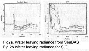
It is critical, then to correct the satellite measured radiance for atmospheric effects if the concentration of chlorophyll and suspended material are to be quantitatively detected (Gordon, 1978). The GSFC NASA had responsibility to lead calibration and validation program, to determine the algorithms of atmospheric correction and chlorophyll inversion of SeaWiFS. The algorithms of SeaWiFS relies on the heritage of CZCS for some of the basic fundamentals of marine optics and atmospheric correction methods. The potential improvements of chlorophyll algorithm and atmospheric correction algorithm have been done, but there is actually no universal algorithm which are suitable for all area globe. The atmospheric algorithm in SeaDAS is suggested not perfect inadequate in the China Sea, because of the dust stream from Mongolia which affects the properties of the air. So, the more accurate algorithm for atmospheric correction by theoretical consideration and in situ measurement of water optics and sampling analysis has been developed in SIO. For example, the comparison of water leaving radiance, which along the typical profile from case 2 coastal water off to the as 1 water, by SaeDAS and by SIO software package are respectively shown in Fig2a and Fig2b .
 .
.Application studies
Mapping chlorophyll and suspended material.
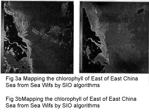
The algorithm of inversion of water-leaving radiance into the chlorophyll and suspended material concentration is another key for SeaWiFS application (Pan etc., 1993). The most area of china Sea belongs to case 2 water which is characterized by very high suspended sediments and chlorophyll concentration. The water leaving radiance is mainly decided by the suspended material.The normal algorithm chlorophyll based on CZCS is fail in the coastal water of China Sea. By the water leaving radiance measurement and sampling analysis. We find that the channels of 555, 670 and 765nm could be applied to calculate chlorophyll concentration which looks like the fluorescence algorithm follows, shown in Fig. 3a,
Chl=0.51*RH670e-0.00693RH670 (1)
Here, chl is the concentration of chlorophyll in mg/m3, the R555, R670 and R765 are water leaving radiance normalized by the solar irradiance, respectively of bands 555, 670,and 765nm..
RH670=R670-0.26(R555-R765) (2)
The channels of 443 and 555nm are good for the measurement of suspended sediment in the coastal water of China Sea as following, shown in Fig. 3b,
ssd=3.2602*(R443/R555)-3.9322 (3)
Here, ssd is the concentration of suspended sediment in g/m3. the R443, R670 and R555 are water leaving radiance normalized of bands 443 and 555nm.
 .
.Red tide detection
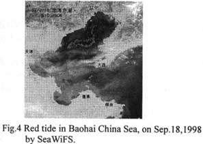
By means of spectral of red tide, we find that the slops of the water leaving radiance of different channels are varied from the normal water. The following formula is used to judged the red tide,
(L555-L510)/(L510/L490)>C (4)
Here, L555, L510, L490is the water leaving radiance of channels of 555, 510 and 490nm. C is the threshold which was obtained from the spectral measurements in situ and laboratory, for the different area. Fig. 4 shows the red tide in Baohai, China Sea on Sep. 18 detected by formula (4)
Kuroshio study
Normally, the AVHRR data is used to study the kuroshio by the AVHRR data during winter, because the temperature of Kurosho is 2-3 degree higher than its surrounded area in the winter or the end of autumn and the beginning of spring. But in warmer season, the temperature is not enough different between Kuroshio and its surround area , so it is difficult to detect the Kuroshio by the AVHRR data. Oppositely, the chlorophyll is more different in the warmer season than in the cold season., then it is more possible to find the Kuroshio by the variation of chlorophyll concentration. We found that the more high concentration of chlorophyll is located on the boundary of Kuroshio because of more distribution between the different layers of water and more nutritious on the boundary. So, the boundary of Kuroshio is shown clearly by it's high chlorophyll concentration from SeaWiFS data in the warmer season.
Conclusion
- SeaWiFS technique system has been developed in China in the last 3
years for scientific research purpose.
- The algorithms which are involved in SeaDAS software package, such
as atmospheric correction and calculation of chlorophyll material, is
not perfect inadequate in the coastal area of China Sea, and have been
modified to be more suitable for Chinese local area.
- The results of application studies on red tide and Kuroshio
detection show the SeaWiFS data very good potentiality in the
environment detection of Chinese coastal water. The Chinese government
has paid more attention this technique and the first Chinese ocean color
satellite HY-1 is planned to be launched in the
2001.
- H.R. Gordon Remove of atmospheric effects from satellite imagery of
the oceans. Applied Optics 17:1631-1636, 1978.
- J. Aiken, G.F. Moore, C.C. Trees et. The SeaWiFS CZCS-Type Pigment
Algorithm, Edi.Elaine R. Firestone, NASA Technical Memorandum 104566,
Vol.29, June, 1995.
- Pan Delu, J.F.R. Gower & Borstad, Seasonal variation of the
surface chlorophyll distribution along the B.C coast as shown by CZCS
satellite imagery. ((Limnology and Oceanography)) 1998, Vol. 33(2),
P227-244.
- Pan Delu etc. Requirements of SeaWiFS data for Chinese ocean color
remote sensing. PRC/CEC Workshop on Contribution to Global Change.
Beijing 26-30 Oct. 1992.
- Pan Delu etc. Ocean color remote sensing for marine environment.
Proceeding of Sym. On Remote Sensing in Environmental Research and
Global Change 3-6 March, HKUST, HK p73-89, 1993.
- Stanford B. Hooker, wayne E. Esaias, Gene C. Feldman ect. An Overview of SeaWiFS and Ocean Color, Edi. Elaine R. Firestone, NASA Technical Memorandum 104566, Vol.1, July, 1992.