| GISdevelopment.net ---> AARS ---> ACRS 1999 ---> Mapping From Space |
Optimum Synthetic Aperture
Radar System Parameters For Rice and Tropic Vegetation Monitoring
Yun Shao1, 2,
Robert N. Treuhaft2
1. Institute of Remote Sensing Applications, Chinese Academy of Sciences, Beijing 100101, China
2. Jet Propulsion Laboratory, California Institute of technology, Pasadena, USA
1. Institute of Remote Sensing Applications, Chinese Academy of Sciences, Beijing 100101, China
2. Jet Propulsion Laboratory, California Institute of technology, Pasadena, USA
Abstract
Rice is the staple grain in southeastern Asia. Its monitoring and yield estimation has special significance to this region. Radar remote sensing is appropriate for monitoring rice, as cultivated areas are most often cloudy and rainy. For this reason, Synthetic Aperture Radar (SAR) is anticipated to be the dominant data source in tropic and sub-tropical regions. SAR satellites can also provide frequent re-visit schedules suitable for agricultural moni-toring. Firstly, this paper presents the results of a study examining the backscatter behavior of rice using multi-temporal RADARSAT dataset. A rice-type distribu-tion map was produced, showing 4 types of rice with different life spans. The accuracy of rice classification was found to be 91%, providing confidence that multi-temporal RADARSAT data is capable of rice monitoring and has potential for yield estimation. Based on the studies in the Zhaoqing test site, it is suggested that rice yield estimations require three radar data acquisitions taken at 3 stages of crop growth: at the end of the seedling development period, in the ear differentiation period, and at the beginning of the harvest period. Alternatively, if multi-parameter radar data is available, only two data acquisitions are required: at the end of the seedling period, and at the beginning of the harvest period. Secondly, this paper presents the potential of polarimetric SAR technology for rice and tropic vegetation monitoring. A suggestion on optimum SAR system parameter selection for this type of application was made for future system design consideration.
Introduction
Rice is a heat and water favorite crop. Most paddy rice in the world grows in warm, humid environment with heavy cloud cover and rainfall. It is hard to acquire optical remote sensing data in rice growing regions. Synthetic Aperture Radar (SAR), with all weather, independent of illumination imaging capability and frequent revisit schedule, is anticipated to be the dominant data source for agriculture monitoring in tropic and sub-tropic regions.
Rice monitoring and yield estimation has special significance to China, as rice is the staple grain and accounts for 42% of the crop yield for this country. The estimation of crop yield is a topic of global interest (McDonald and Hall, 1980), and the efficient management of agricultural land resources is strongly related to social and economic sustainable development, especially in China. It is well known that China is the largest country in population. However, as the population increases, and economy and industry develop, the quantity and quality of cultivated land is decreasing rapidly. The food supply to the current 1.2 billion people is a serious concern facing China, and will intensify as the population continues to grow. Therefore, it is important to find an efficient way to face this dilemma. Remote sensing technology will provide the needed information on crop distribution, acreage and potential yield.
This paper presents the results of a study examining the backscatter behavior of rice using multi-temporal RADARSAT dataset. A rice-type distribution map was produced, showing 4 types of rice with different life spans ranging from 80 days, to 120-125 days. Based on previous studies in the Zhaoqing test site, it is suggested that rice yield estimations require three radar data acquisitions. Alternatively, if multi-parameter radar data is available, only two data acquisitions are required.
Test Site and Data Source
The Zhaoqing test site is located in Guangdong Province, south of China center at latitude 22.30, longitude 112.30. It is sited at the northwestern end of Pearl River Delta. The test site was firstly imaged by airborne SAR in 1993 under the GlobeSAR program (Shao, 1995, 1996; Guo 1997). The Shuttle Imaging Radar C-band (SIR-C) and X-band SAR (X-SAR) also flew over the area on April 18, 1994. In addition, there were multiple RADARSAT images acquired from March to December in1996, and from April to July in 1997. The system parameters, imaging modes, and acquisition dates of images used in this study are listed in table 1.
Table 1. System Parameters of SAR Data
Rice Calendar
In the Zhaoqing test site, there are two crops per year; early season rice and late season rice. There are five major growth periods in the life cycle of rice. 1) Transplanting period: rice plant seedlings are transplanted from the seedbed to the paddy field. The transplanting date depends on the weather, especially temperature; 2) Seedling developing period: the seedling splits up and begins to develop a root system; 3) Ear differentiation period; 4) Heading period: headings begin to form; 5) Mature period: the rice plants mature and are ready to be harvested. Temporally, these five periods for early season rice are March 25-April 5, April 15-25, May 10-30, June 10-25, July 5-31. For late season rice, the growth stages occur as follows: July 20-August 5, August 10-20, September 1-30, October 1-20, November 1-25 respectively.
With progress in agricultural technology, it is known that the longer the rice lifetime, the higher the yield will be. For this reason, the transplanting date of rice is getting earlier. Plant maturity rates and lifetimes are species dependent.
Temporal Backscatter Behavior of Rice
This study aimed at understanding the backscatter behavior of rice over its whole life circle, and the relationship between the rice structure parameters and its backscatter coefficients. Based on a good understanding of backscatter characteristics of rice, we can then suggest the best date for radar data acquisition to monitor the rice growth and estimate the yield. Figures 1 and 2 show the backscatter coefficients of rice extracted from calibrated RADARSAT images acquired from summer to autumn in 1996 and from spring to summer of 1997 respectively. These are produced by applying the calibration procedure to the digital number of Radarsat image to produce s 0 for a training area (20 pixel by 20 pixel) of the multi-temporal RADARSAT dataset.
Figure 1. Backscatter coefficients of
rice as a function of time (1996)
![]()
Figure 2. Backscatter coefficients of rice as a function of time (1997)
![]()
Figure 3. Theoretical backscatter model of rice (based on the backscatter behavior of medium-late mature rice of 1997)

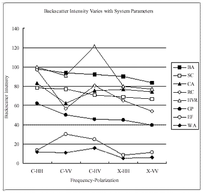
In figure 4, there are five types of rice: 1) medium mature rice. 2) late mature rice. The backscatter coefficient of late mature rice is slightly higher than medium mature rice on August 4. 3) Late transplanted rice, which has been transplanted about 25 days later than the normal spring rice, due to a cold spring and low temperatures in 1996. The RADARSAT image acquired on April 25 shows the backscatter coefficients of these fields as very low, responding similar to a still water body. The backscatter coefficients from the RADARSAT images taken after April 25 increase gradually, until September when the rice is harvested. Its life span is relatively short, and the backscatter coefficients are lower. 4) single rice and 5) autumn rice. These two rice types demonstrate how farming activities can change within a year, switch between fish ponds and rice fields. Spring rice was a rice field in spring then switched a fish pond in autumn. Conversely, Autumn rice was a fish pond in spring then switched to rice field in autumn. This practice is very common in Zhaoqing area, as well as many other parts of China. In general, this swap of fish pond and rice implies that the quality of the field is less than excellent, and that the rice yield is normally lower. Based on the classification results of the 1996 multi-temporal fine mode RADARSAT dataset, A land cover map was produced clearly showing the five types of rice, as well as other vegetation covers and targets.
Figure 4. Backscatter intensity of
the targets in relation to polarization and frequency (based on the CV-580
data)
In figure 2, there are four major types of rice with different growth cycles. With the knowledge gained from the rice backscatter behavior of 1996, we can distinguish between rice types quite easily. They are early mature rice, medium mature rice, medium-late mature rice, and late mature rice. Their life span is about 80 days, 100 -115 days, 110-120 days and 120-125 days respectively. A false-color fusion image is produced based on the multi-temporal Standard mode RADARSAT images acquired in the spring of 1997. A rice distribution map is produced using the 7 RADARSAT scenes. If a type of rice has higher backscatter value in April, at the early stage or seedling development period, as found with late mature rice, then it was transplanted earlier than the other types of rice. If a type of rice has higher backscatter coefficients in July, the late stage or the harvest period, the rice is harvested later than other type of rice, as found with medium-late mature rice. From figure 2 we can conclude that late mature rice has the longest lifetime. The medium-late mature rice was transplanted a few days later than medium mature rice and late mature rice, and harvested later. The medium mature rice was harvested before July 22. From figure 2, we can see that early mature rice was harvested before June 28. It has very lower backscatter coefficients since early harvest period. It is concluded that from the early stage, 25 days after transplanting, and late stage, 80 days after transplanting, we can distinguish the rice life span easily, which is an important information for rice yield estimation. The life span is directly related to the yield and quality of rice. This information is provided by local agronomists. It has been proved in real life. The farmer used to grow three rice crops a year in past, nowadays, they only grow two rice crops a year and they make more money from rice farming.
Based on figure 2, the knowledge we had in our research started in 1993, we established the theoretic backscatter model of rice. Figure 3 mainly represents the backscatter behavior of medium-late mature rice produced by the theoretic backscatter model. It is transplanted in April 1 and harvested in July 30. The late mature rice and medium mature rice are transplanted earlier than medium-late mature rice. Medium mature rice is harvested earlier than medium-late mature rice. This model can be applied to other type of rice with the information on rice life span, transplant date and harvest date. Then we can calculate the backscatter coefficients of rice at certain growth stage.
The results from the studies carried out in 1996 and 1997 imply that the most important radar data acquisition time for rice monitoring is at the end of the seedling period and ear differentiation period, which is late April for spring rice and late August for autumn rice. For calculating the acreage of planted rice, two radar data acquisitions are required: one near the end of April, and another in the middle of May during the ear differentiation period. For rice yield estimation, three radar data acquisitions are required: one at the end of April, one in the middle of May, and one at the end of June. For autumn rice or late season rice, the corresponding date can be found by checking the rice growth calendar.
A rice-type distribution map was produced, showing 4 types of rice with different life spans ranging from 80 days, to 120-125 days. The life span of a rice crop has significant impact on yield, as well as the taste and quality of the rice. The yield of three counties and two administrative regions, totaling 5000 square kilometers, are estimated in this study. The accuracy was found to be 91%, providing confidence that multi-temporal RADARSAT data is capable of rice monitoring and yield estimation. Based on previous studies in the Zhaoqing test site, it is suggested that rice yield estimations require three radar data acquisitions taken at 3 stages of crop growth: at the end of the seedling development period, in the ear differentiation period, and at the beginning of the harvest period. Alternatively, if multi-parameter radar data is available, only two data acquisitions are required: at the end of the seedling period, and at the beginning of the harvest period.
Optimum SAR System Parameter for Rice and Tropic Vegetation Monitoring
Figure 4 and 5 were delivered from Canadian airborne radar system-CV-580, with X and C band, quad-polarization and USA SIR-C/X-SAR with X, C and L band, HH, HV, VV polarization. These two figures show great advantage of multi-frequency, multi-polarization radar system in rice and tropic vegetation discrimination. The detail will be made in presentation.
Figure 5. Comparison of intensity of
rice and water in relation to polarization and frequency (based on
SIR-C/X-SAR data)
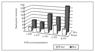
It is suggested that the optimum SAR system parameter for rice and tropic vegetation monitoring should be C and L band, polarimetric is favorite if it is possible, if not, HH, VV or HV polarization are the least, 10-25 meter spatial resolution, 8-16 days revisit schedule, 35-45 incidence angle, as wide swath as possible to cover large area and bring the cost down.
Rice is the staple grain in southeastern Asia. Its monitoring and yield estimation has special significance to this region. Radar remote sensing is appropriate for monitoring rice, as cultivated areas are most often cloudy and rainy. For this reason, Synthetic Aperture Radar (SAR) is anticipated to be the dominant data source in tropic and sub-tropical regions. SAR satellites can also provide frequent re-visit schedules suitable for agricultural moni-toring. Firstly, this paper presents the results of a study examining the backscatter behavior of rice using multi-temporal RADARSAT dataset. A rice-type distribu-tion map was produced, showing 4 types of rice with different life spans. The accuracy of rice classification was found to be 91%, providing confidence that multi-temporal RADARSAT data is capable of rice monitoring and has potential for yield estimation. Based on the studies in the Zhaoqing test site, it is suggested that rice yield estimations require three radar data acquisitions taken at 3 stages of crop growth: at the end of the seedling development period, in the ear differentiation period, and at the beginning of the harvest period. Alternatively, if multi-parameter radar data is available, only two data acquisitions are required: at the end of the seedling period, and at the beginning of the harvest period. Secondly, this paper presents the potential of polarimetric SAR technology for rice and tropic vegetation monitoring. A suggestion on optimum SAR system parameter selection for this type of application was made for future system design consideration.
Introduction
Rice is a heat and water favorite crop. Most paddy rice in the world grows in warm, humid environment with heavy cloud cover and rainfall. It is hard to acquire optical remote sensing data in rice growing regions. Synthetic Aperture Radar (SAR), with all weather, independent of illumination imaging capability and frequent revisit schedule, is anticipated to be the dominant data source for agriculture monitoring in tropic and sub-tropic regions.
Rice monitoring and yield estimation has special significance to China, as rice is the staple grain and accounts for 42% of the crop yield for this country. The estimation of crop yield is a topic of global interest (McDonald and Hall, 1980), and the efficient management of agricultural land resources is strongly related to social and economic sustainable development, especially in China. It is well known that China is the largest country in population. However, as the population increases, and economy and industry develop, the quantity and quality of cultivated land is decreasing rapidly. The food supply to the current 1.2 billion people is a serious concern facing China, and will intensify as the population continues to grow. Therefore, it is important to find an efficient way to face this dilemma. Remote sensing technology will provide the needed information on crop distribution, acreage and potential yield.
This paper presents the results of a study examining the backscatter behavior of rice using multi-temporal RADARSAT dataset. A rice-type distribution map was produced, showing 4 types of rice with different life spans ranging from 80 days, to 120-125 days. Based on previous studies in the Zhaoqing test site, it is suggested that rice yield estimations require three radar data acquisitions. Alternatively, if multi-parameter radar data is available, only two data acquisitions are required.
Test Site and Data Source
The Zhaoqing test site is located in Guangdong Province, south of China center at latitude 22.30, longitude 112.30. It is sited at the northwestern end of Pearl River Delta. The test site was firstly imaged by airborne SAR in 1993 under the GlobeSAR program (Shao, 1995, 1996; Guo 1997). The Shuttle Imaging Radar C-band (SIR-C) and X-band SAR (X-SAR) also flew over the area on April 18, 1994. In addition, there were multiple RADARSAT images acquired from March to December in1996, and from April to July in 1997. The system parameters, imaging modes, and acquisition dates of images used in this study are listed in table 1.
| Parameters | Data Source | GlobeSAR | SIR-C/X-SAR | RADARSAT (Fine) | RADARSAT (Standard) |
| Frequency (GHz) | C X 5.30 9.25 |
L C X 1.24 5.3 9.6 | C 5.3 |
C 5.3 | |
| Polarization | HH, HV HH VV, VH VV |
HH HH VV HV HV |
HH | HH | |
| Incidence Angle (°) | 14-45 | 34.1 | 43-46(f4) | 36-42(S5), 41.46(S6) | |
| Nominal Resolution (m) | 6*6 | 25*25 12.5*12.5 | 10*10 | 30*30 | |
| Pixel Spacing (m) | 6*6 | 25*25 | 6.25*6.25 | 12.5*12.5 | |
| Swath Width (km) | 18 | 37.8 | 50 | 100 | |
| Imaging Date | Nov.20,21,93 | April 18,94 | Multi-temporal | Multi-temporal | |
Rice Calendar
In the Zhaoqing test site, there are two crops per year; early season rice and late season rice. There are five major growth periods in the life cycle of rice. 1) Transplanting period: rice plant seedlings are transplanted from the seedbed to the paddy field. The transplanting date depends on the weather, especially temperature; 2) Seedling developing period: the seedling splits up and begins to develop a root system; 3) Ear differentiation period; 4) Heading period: headings begin to form; 5) Mature period: the rice plants mature and are ready to be harvested. Temporally, these five periods for early season rice are March 25-April 5, April 15-25, May 10-30, June 10-25, July 5-31. For late season rice, the growth stages occur as follows: July 20-August 5, August 10-20, September 1-30, October 1-20, November 1-25 respectively.
With progress in agricultural technology, it is known that the longer the rice lifetime, the higher the yield will be. For this reason, the transplanting date of rice is getting earlier. Plant maturity rates and lifetimes are species dependent.
Temporal Backscatter Behavior of Rice
This study aimed at understanding the backscatter behavior of rice over its whole life circle, and the relationship between the rice structure parameters and its backscatter coefficients. Based on a good understanding of backscatter characteristics of rice, we can then suggest the best date for radar data acquisition to monitor the rice growth and estimate the yield. Figures 1 and 2 show the backscatter coefficients of rice extracted from calibrated RADARSAT images acquired from summer to autumn in 1996 and from spring to summer of 1997 respectively. These are produced by applying the calibration procedure to the digital number of Radarsat image to produce s 0 for a training area (20 pixel by 20 pixel) of the multi-temporal RADARSAT dataset.
Figure 2. Backscatter coefficients of rice as a function of time (1997)
Figure 3. Theoretical backscatter model of rice (based on the backscatter behavior of medium-late mature rice of 1997)
In figure 4, there are five types of rice: 1) medium mature rice. 2) late mature rice. The backscatter coefficient of late mature rice is slightly higher than medium mature rice on August 4. 3) Late transplanted rice, which has been transplanted about 25 days later than the normal spring rice, due to a cold spring and low temperatures in 1996. The RADARSAT image acquired on April 25 shows the backscatter coefficients of these fields as very low, responding similar to a still water body. The backscatter coefficients from the RADARSAT images taken after April 25 increase gradually, until September when the rice is harvested. Its life span is relatively short, and the backscatter coefficients are lower. 4) single rice and 5) autumn rice. These two rice types demonstrate how farming activities can change within a year, switch between fish ponds and rice fields. Spring rice was a rice field in spring then switched a fish pond in autumn. Conversely, Autumn rice was a fish pond in spring then switched to rice field in autumn. This practice is very common in Zhaoqing area, as well as many other parts of China. In general, this swap of fish pond and rice implies that the quality of the field is less than excellent, and that the rice yield is normally lower. Based on the classification results of the 1996 multi-temporal fine mode RADARSAT dataset, A land cover map was produced clearly showing the five types of rice, as well as other vegetation covers and targets.
In figure 2, there are four major types of rice with different growth cycles. With the knowledge gained from the rice backscatter behavior of 1996, we can distinguish between rice types quite easily. They are early mature rice, medium mature rice, medium-late mature rice, and late mature rice. Their life span is about 80 days, 100 -115 days, 110-120 days and 120-125 days respectively. A false-color fusion image is produced based on the multi-temporal Standard mode RADARSAT images acquired in the spring of 1997. A rice distribution map is produced using the 7 RADARSAT scenes. If a type of rice has higher backscatter value in April, at the early stage or seedling development period, as found with late mature rice, then it was transplanted earlier than the other types of rice. If a type of rice has higher backscatter coefficients in July, the late stage or the harvest period, the rice is harvested later than other type of rice, as found with medium-late mature rice. From figure 2 we can conclude that late mature rice has the longest lifetime. The medium-late mature rice was transplanted a few days later than medium mature rice and late mature rice, and harvested later. The medium mature rice was harvested before July 22. From figure 2, we can see that early mature rice was harvested before June 28. It has very lower backscatter coefficients since early harvest period. It is concluded that from the early stage, 25 days after transplanting, and late stage, 80 days after transplanting, we can distinguish the rice life span easily, which is an important information for rice yield estimation. The life span is directly related to the yield and quality of rice. This information is provided by local agronomists. It has been proved in real life. The farmer used to grow three rice crops a year in past, nowadays, they only grow two rice crops a year and they make more money from rice farming.
Based on figure 2, the knowledge we had in our research started in 1993, we established the theoretic backscatter model of rice. Figure 3 mainly represents the backscatter behavior of medium-late mature rice produced by the theoretic backscatter model. It is transplanted in April 1 and harvested in July 30. The late mature rice and medium mature rice are transplanted earlier than medium-late mature rice. Medium mature rice is harvested earlier than medium-late mature rice. This model can be applied to other type of rice with the information on rice life span, transplant date and harvest date. Then we can calculate the backscatter coefficients of rice at certain growth stage.
The results from the studies carried out in 1996 and 1997 imply that the most important radar data acquisition time for rice monitoring is at the end of the seedling period and ear differentiation period, which is late April for spring rice and late August for autumn rice. For calculating the acreage of planted rice, two radar data acquisitions are required: one near the end of April, and another in the middle of May during the ear differentiation period. For rice yield estimation, three radar data acquisitions are required: one at the end of April, one in the middle of May, and one at the end of June. For autumn rice or late season rice, the corresponding date can be found by checking the rice growth calendar.
A rice-type distribution map was produced, showing 4 types of rice with different life spans ranging from 80 days, to 120-125 days. The life span of a rice crop has significant impact on yield, as well as the taste and quality of the rice. The yield of three counties and two administrative regions, totaling 5000 square kilometers, are estimated in this study. The accuracy was found to be 91%, providing confidence that multi-temporal RADARSAT data is capable of rice monitoring and yield estimation. Based on previous studies in the Zhaoqing test site, it is suggested that rice yield estimations require three radar data acquisitions taken at 3 stages of crop growth: at the end of the seedling development period, in the ear differentiation period, and at the beginning of the harvest period. Alternatively, if multi-parameter radar data is available, only two data acquisitions are required: at the end of the seedling period, and at the beginning of the harvest period.
Optimum SAR System Parameter for Rice and Tropic Vegetation Monitoring
Figure 4 and 5 were delivered from Canadian airborne radar system-CV-580, with X and C band, quad-polarization and USA SIR-C/X-SAR with X, C and L band, HH, HV, VV polarization. These two figures show great advantage of multi-frequency, multi-polarization radar system in rice and tropic vegetation discrimination. The detail will be made in presentation.
It is suggested that the optimum SAR system parameter for rice and tropic vegetation monitoring should be C and L band, polarimetric is favorite if it is possible, if not, HH, VV or HV polarization are the least, 10-25 meter spatial resolution, 8-16 days revisit schedule, 35-45 incidence angle, as wide swath as possible to cover large area and bring the cost down.