| GISdevelopment.net ---> AARS ---> ACRS 1999 ---> Mapping From Space |
A Digital Airborne Camera
System for Photogrammetry and Thematic Applications
Helmut Heier, Alexander
Hinz
Z/I Imaging GmbH
73442 Oberkochen, Germany
Fax : +49-7364-20 3724
E-Mail: heier@zeiss.de
Z/I Imaging GmbH
73442 Oberkochen, Germany
Fax : +49-7364-20 3724
E-Mail: heier@zeiss.de
Abstract
At this moment fundamental changes in sensors, platforms and applications are taking place. Market needs for the use of airborne and spaceborne imagery are changing. Soon there will be new high resolution spaceborne sensors available. Besides Photogrammetry new thematic applications will drive the future image market. Needs like cost saving, time saving, higher and reproducible radiometric resolution or spectral information will drive the change from analog to digital imagery. High resolution satellites will compete with airborne film based photography and digital camera systems.
During the last 20 years several airborne sensors working with high resolution CCD lines were developed and tested. High resolution CCD matrix sensors with several million pixels are nowadays also available as a result of high resolution professional photography. But a digital camera is more than only the exchange of film against silicon. The number of picture elements is only one parameter. As-pects like data transfer rates, in-flight data storage, image archiving, geo-referencing, color fusion, cali-bration and preprocessing have the same influence on the economical assessment of a digital camera system. The paper describes actual development activities and application aspects of a modular digital airborne camera system.
1. Introduction
For many decades Aerial Cameras developed and manufactured by Carl Zeiss Photogram-metry Division have been successfully used all over the world as high performance systems for aerial photography. Since April 1, 1999, this Carl Zeiss tradition is being continued by the Z/I-Imaging GmbH Oberkochen. Z/I IMAGING will cover the entire photogrammetric workflow end-to-end. Aerial mapping cameras like the RMK-TOP have been used for decades. In recent years they have evolved from purely airborne cameras into complex system solutions through the compensation of aircraft mo-tions, photoflight management with GPS navigation, and the use of measurement methods for the pre-cise determination of the exterior orientation. 230 mm wet film with different specifications is still be-ing used in a wide field of applications for image taking and image storage. This camera systems are mostly used for mapping applications with photo scale between 1:5.000 and 1:15.000.
2. Airborne Remote Sensing Market
To establish a market for digital airborne cameras, they have to offer clear advantages in com-parison with film based systems. For each application an investigation is required to define the digital advantages. An analysis of the technical capabilities of digital imaging sensors in the photogrammetric workflow allows the benefits for the overall process to be assigned to 4 groups :
3. Market Forecast
The aerial image market as demand originator for airborne cameras is a part of the GIS market. The future development of this market has been investigated in various market studies (CEO 1995, Dataquest 1996, EIA 1994, Frost&Sullivan 1996, OTA 1994). All this mar-ket surveys show a significant growth in the decade from 1995 to 2005 (Figure 1). Interest-ing are the changes in the market segments Na-tional Security and Civil Administration on one side and Commercial Applications on the other side. A major trend seems to be that the public sectors will stagnate or shrink and a clear growth impetus will only come from new com-mercial applications. This area will grow by approx. 500% and this area will drive the need for new digital cameras.
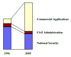
Figure 1: World GIS - Market Forecast
3.1 . Future Airborne Applications
For the conception of new airborne camera systems, the opportunities resulting from these changes in the GIS market have to be considered. The demand in classical aerial imaging applications such as cartography will stagnate and perhaps even shrink in the coming years, while a market segment for new commercial applications will develop (Table 1). In part this involves applications from the field of remote sensing, which benefit from the expanded spectral capabilities of digital imaging sen-sors. As can be seen from this survey, these commercial applications have some quite different re-quirements than map production by means of analog aerial imagery.
3.2 . Image Market
In the future, three different data sources have to be reckoned with in the photogrammetric image market:
Table 1 : Future Applications of
Airborne Imagery
3.3 . Image Market Trends
4. Requirements Airborne Digital Cameras
This analysis of the image market indicates the demands for digital airborne camera systems. To complement high-resolution satellite images, a ground resolution of better than 1.0 m and multis-pectral features of approx. 450 to 900 nm are required. A special competition will arise between film based aerial mapping cameras and digital airborne cameras. Both system are being used in planes under comparable conditions. Compared with the aerial mapping camera, the digital airborne camera offers
These numbers imply that time isn't and technology haven't matured for a 100% replacement of aerial mapping cameras. The question of the pixel numbers required of a digital airborne camera cannot be answered by comparing frame formats and pixel sizes only. When flying along linear objects such as roads, utility lines or coastlines, the 230 mm film format of an aerial mapping camera is not fully used. In spatially limited applications the data volume and the image quantities are also limited. In these applications it is possible to use digital cameras economically already today. The definition of the most economic digital resolution depends on the application. The user will accept digital technology only when this offers an advantage over existing systems from an economical viewpoint. For this pur-pose, the entire process chain starting from the flight planning up to the finished product in the form of a map or orthophoto must be analyzed (Heier,1999).
5. System Description
When selecting a digital camera system, it is not only the camera onboard the plane which needs to be taken into consideration, but the entire process must be analyzed including the final product and data archiving. The flight system includes the actual digital camera for recording image data and the usual equipment such as navigation systems, flight management system, GPS- INS, a stabilized platform, etc. The centerpiece of the system is the camera head and the CCD sensor as the core element. Z/I-Imaging has decided to develop a new digital camera generation on the basis of CCD matrix sen-sors. The driving factor for this decision was an intensive evaluation of the competing approaches on the basis of a line sensor and a matrix solution (Hinz, 1997).
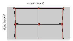
Figure 2 : Ground coverage of 4 camerahead system
Each CCD chip is assigned its own lens. Today, CCD chips are available in pixel sizes from the consumer market of 2 million pixels. In the field of professional photography, 6 million pixels (2Kx3K) are available as a result of reliable high-volume production. Different manufacturers (Kodak, Philips, Lockheed Martin) offer chips between 4Kx4K and 9Kx9K, with pixel sizes of 9µm to 12µm, which are produced in small series. The main idea behind this approach is the system's modular design with rapid adaptability of new developments in the field of CCD, microcomputer and mass storage technology. Depending on the application, several camera heads can be combined as shown in figure 3.
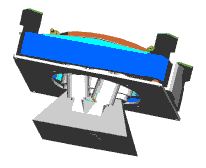
Figure 3 : Illustration of optical arrangement of 7 head camera
The system consists of a camera configuration integrated in the stabilized T-AS platform. The panchromatic channel has been implemented with 4 cameras. The spectral channels with a resolution reduced by half in the linear dimension, have one camera each for red, green and blue, covering an identical ground area. The pyramid cones shown in the illustration represent the different field angles of the lenses. The system can be extended by additional spectral channels (i.e. Infrared) for remote sensing applications.
The camera heads can be operated in FMC (Forward Motion Compensation) mode. FMC is one of the most important milestones in aerial photography and was introduced by Carl Zeiss Jena in 1982 (G.Voss, 1983). A full frame matrix CCD sensor implements FMC on a completely electronic basis and allows to improve the reliability of this method quite significant. The technique has been success-fully used by IGN (C.Thom 1997) for photo-grammetric purposes, and was demonstrated for Recce cameras by Recon Optical and Lockhead Martin (B. Mathews, 1998).
6. Conclusion
New applications and new image data sources will impact the market for aerial imagery sig-nificantly in the coming years. These changes as well as advances in the sensor and computer fields will soon make the use of digital airborne cameras economical. Before the 230 mm film technology can be replaced by digital sensors, some major tasks will have to be solved in the sensor resolution and data processing fields. This development can be seen in the medium to long term. The digital camera intro-duced by Z/I-Imaging is based on a matrix CCD-Sensor. This approach offers the best geometric accu-racy for photogrammetric applications, without any reliance on inertial and GPS data. The high intrin-sic accuracy is determined by the two dimensional CCD-matrix on top of a silicon wafer. It more or less offers several million well defined fiducials (=number of CCD-pixels) in the image plane of the aerial photo. The modular approach allows the combination of several compact camera heads offering cross track coverage in the same range as standard wide angle aerial cameras. High flexibility allows adaptation of resolution and spectral channels to the customers needs. The resulting digital image has the usual central perspective geometry, thus maintaining interfacing and compatibility to existing soft copy solutions. For the near future, the coexistence of large format film based aerial cameras and the new digital generation of cameras will be observed. The introduction of the new quality and applica-tions of digital camera systems will be an evolutionary process with demanding objectives.
7. References
At this moment fundamental changes in sensors, platforms and applications are taking place. Market needs for the use of airborne and spaceborne imagery are changing. Soon there will be new high resolution spaceborne sensors available. Besides Photogrammetry new thematic applications will drive the future image market. Needs like cost saving, time saving, higher and reproducible radiometric resolution or spectral information will drive the change from analog to digital imagery. High resolution satellites will compete with airborne film based photography and digital camera systems.
During the last 20 years several airborne sensors working with high resolution CCD lines were developed and tested. High resolution CCD matrix sensors with several million pixels are nowadays also available as a result of high resolution professional photography. But a digital camera is more than only the exchange of film against silicon. The number of picture elements is only one parameter. As-pects like data transfer rates, in-flight data storage, image archiving, geo-referencing, color fusion, cali-bration and preprocessing have the same influence on the economical assessment of a digital camera system. The paper describes actual development activities and application aspects of a modular digital airborne camera system.
1. Introduction
For many decades Aerial Cameras developed and manufactured by Carl Zeiss Photogram-metry Division have been successfully used all over the world as high performance systems for aerial photography. Since April 1, 1999, this Carl Zeiss tradition is being continued by the Z/I-Imaging GmbH Oberkochen. Z/I IMAGING will cover the entire photogrammetric workflow end-to-end. Aerial mapping cameras like the RMK-TOP have been used for decades. In recent years they have evolved from purely airborne cameras into complex system solutions through the compensation of aircraft mo-tions, photoflight management with GPS navigation, and the use of measurement methods for the pre-cise determination of the exterior orientation. 230 mm wet film with different specifications is still be-ing used in a wide field of applications for image taking and image storage. This camera systems are mostly used for mapping applications with photo scale between 1:5.000 and 1:15.000.
2. Airborne Remote Sensing Market
To establish a market for digital airborne cameras, they have to offer clear advantages in com-parison with film based systems. For each application an investigation is required to define the digital advantages. An analysis of the technical capabilities of digital imaging sensors in the photogrammetric workflow allows the benefits for the overall process to be assigned to 4 groups :
- cost saving
- time saving
- higher image quality
- new applications
3. Market Forecast
The aerial image market as demand originator for airborne cameras is a part of the GIS market. The future development of this market has been investigated in various market studies (CEO 1995, Dataquest 1996, EIA 1994, Frost&Sullivan 1996, OTA 1994). All this mar-ket surveys show a significant growth in the decade from 1995 to 2005 (Figure 1). Interest-ing are the changes in the market segments Na-tional Security and Civil Administration on one side and Commercial Applications on the other side. A major trend seems to be that the public sectors will stagnate or shrink and a clear growth impetus will only come from new com-mercial applications. This area will grow by approx. 500% and this area will drive the need for new digital cameras.
Figure 1: World GIS - Market Forecast
3.1 . Future Airborne Applications
For the conception of new airborne camera systems, the opportunities resulting from these changes in the GIS market have to be considered. The demand in classical aerial imaging applications such as cartography will stagnate and perhaps even shrink in the coming years, while a market segment for new commercial applications will develop (Table 1). In part this involves applications from the field of remote sensing, which benefit from the expanded spectral capabilities of digital imaging sen-sors. As can be seen from this survey, these commercial applications have some quite different re-quirements than map production by means of analog aerial imagery.
3.2 . Image Market
In the future, three different data sources have to be reckoned with in the photogrammetric image market:
- High-resolution earth observation satellites
- Digital airborne cameras
- High-resolution analog aerial mapping cameras
| Application | Description |
| Mapping | City and county governments, cartographic departments, remote sensing companies; photo scale 1:5.000 - 1:50.000 |
| Construction | overground + underground building, facility management, supply lines, small events; photo scale 1:3.000 - 1:7.000 |
| Infrastructure | route planning and monitoring of pipelines, railways, streets, corridor applications; photo scale 1:3.000 - 1:7.000 |
| Telecommunication | 3D-models of the city buildings |
| Agriculture | monitor crop yield, soil, stress, and impacts of pests and disease |
| Forestry | monitor tree yield, tree trimming, fire |
| Insurance | high resolution data in a very short time e.g. height resolution 0,1 m for flood monitoring |
| Disaster Management | quick reaction within hours |
3.3 . Image Market Trends
- Shift from "Performance Enhancement" to "Affordability Improvement"
- New methods for distribution; e.g. direct sales via the Internet
- New services for the consumer market; e.g. satellite images on CD-ROM
- Low-cost geo-coded image data
- Preprocessing of image data is a challenge for photoflight companies
- Image data will become a commodity
4. Requirements Airborne Digital Cameras
This analysis of the image market indicates the demands for digital airborne camera systems. To complement high-resolution satellite images, a ground resolution of better than 1.0 m and multis-pectral features of approx. 450 to 900 nm are required. A special competition will arise between film based aerial mapping cameras and digital airborne cameras. Both system are being used in planes under comparable conditions. Compared with the aerial mapping camera, the digital airborne camera offers
- higher radiometric resolution
- reproducible color information
- cost savings for film
- cost savings for film processing
- cost savings for scanning
- immediate availability of the image data
These numbers imply that time isn't and technology haven't matured for a 100% replacement of aerial mapping cameras. The question of the pixel numbers required of a digital airborne camera cannot be answered by comparing frame formats and pixel sizes only. When flying along linear objects such as roads, utility lines or coastlines, the 230 mm film format of an aerial mapping camera is not fully used. In spatially limited applications the data volume and the image quantities are also limited. In these applications it is possible to use digital cameras economically already today. The definition of the most economic digital resolution depends on the application. The user will accept digital technology only when this offers an advantage over existing systems from an economical viewpoint. For this pur-pose, the entire process chain starting from the flight planning up to the finished product in the form of a map or orthophoto must be analyzed (Heier,1999).
5. System Description
When selecting a digital camera system, it is not only the camera onboard the plane which needs to be taken into consideration, but the entire process must be analyzed including the final product and data archiving. The flight system includes the actual digital camera for recording image data and the usual equipment such as navigation systems, flight management system, GPS- INS, a stabilized platform, etc. The centerpiece of the system is the camera head and the CCD sensor as the core element. Z/I-Imaging has decided to develop a new digital camera generation on the basis of CCD matrix sen-sors. The driving factor for this decision was an intensive evaluation of the competing approaches on the basis of a line sensor and a matrix solution (Hinz, 1997).
- Clear benefits of the matrix sensor :
- defined, rigid geometry of the recorded image
- Forward Motion Compensation (FMC) to reduce image blur
- Quadratic pixel footprints
- usual, central perspective image recording geometry
- interfacing to existing softcopy systems software
Figure 2 : Ground coverage of 4 camerahead system
Each CCD chip is assigned its own lens. Today, CCD chips are available in pixel sizes from the consumer market of 2 million pixels. In the field of professional photography, 6 million pixels (2Kx3K) are available as a result of reliable high-volume production. Different manufacturers (Kodak, Philips, Lockheed Martin) offer chips between 4Kx4K and 9Kx9K, with pixel sizes of 9µm to 12µm, which are produced in small series. The main idea behind this approach is the system's modular design with rapid adaptability of new developments in the field of CCD, microcomputer and mass storage technology. Depending on the application, several camera heads can be combined as shown in figure 3.
Figure 3 : Illustration of optical arrangement of 7 head camera
The system consists of a camera configuration integrated in the stabilized T-AS platform. The panchromatic channel has been implemented with 4 cameras. The spectral channels with a resolution reduced by half in the linear dimension, have one camera each for red, green and blue, covering an identical ground area. The pyramid cones shown in the illustration represent the different field angles of the lenses. The system can be extended by additional spectral channels (i.e. Infrared) for remote sensing applications.
The camera heads can be operated in FMC (Forward Motion Compensation) mode. FMC is one of the most important milestones in aerial photography and was introduced by Carl Zeiss Jena in 1982 (G.Voss, 1983). A full frame matrix CCD sensor implements FMC on a completely electronic basis and allows to improve the reliability of this method quite significant. The technique has been success-fully used by IGN (C.Thom 1997) for photo-grammetric purposes, and was demonstrated for Recce cameras by Recon Optical and Lockhead Martin (B. Mathews, 1998).
6. Conclusion
New applications and new image data sources will impact the market for aerial imagery sig-nificantly in the coming years. These changes as well as advances in the sensor and computer fields will soon make the use of digital airborne cameras economical. Before the 230 mm film technology can be replaced by digital sensors, some major tasks will have to be solved in the sensor resolution and data processing fields. This development can be seen in the medium to long term. The digital camera intro-duced by Z/I-Imaging is based on a matrix CCD-Sensor. This approach offers the best geometric accu-racy for photogrammetric applications, without any reliance on inertial and GPS data. The high intrin-sic accuracy is determined by the two dimensional CCD-matrix on top of a silicon wafer. It more or less offers several million well defined fiducials (=number of CCD-pixels) in the image plane of the aerial photo. The modular approach allows the combination of several compact camera heads offering cross track coverage in the same range as standard wide angle aerial cameras. High flexibility allows adaptation of resolution and spectral channels to the customers needs. The resulting digital image has the usual central perspective geometry, thus maintaining interfacing and compatibility to existing soft copy solutions. For the near future, the coexistence of large format film based aerial cameras and the new digital generation of cameras will be observed. The introduction of the new quality and applica-tions of digital camera systems will be an evolutionary process with demanding objectives.
7. References
- CEO (1995) : Centre for Earth Observation, Market and Impact Assesment, CEO/171/1995 Dataquest(1996): GIS Market - Changes on the Horizon„; CAEC-WW-MT-9601
- EIA (1994) : Electronic Industries Association: „Remote Sensing Market Study - Ten Year Forecast„
- Frost&Sullivan (1996) : Frost & Sullivan: „World Geographic Systems Market„, Report # 5382-70
- Heier, H. (1999): Applications and Market for Digital Airborne Cameras.
- In : Photogrammetric Week ´99, Eds D. Fritsch / R. Spiller, Wichmann, Heidelberg
- Hinz, A. (1997): Design Concepts for Digital Photogrammetric Cameras.
- In : Photogrammetric Week ´97, D. Hobbie, Wichmann, Heidelberg pp 43-48
- Hinz, A. (1999): The Z/I-Imaging Digital Aerial Camera System
- In: Photogrammetric Week ´99, Eds D. Fritsch / R. Spiller, Wichmann, Heidelberg
- Mathews, B. (1998): An ultra high resolution, electro-optical framing camera for reconnaissance and other applications.
- In : Proc. SPIE Vol. 3431 Airborne Reconnaissance XXII, San Diego, pp 144-154
- OTA (1994) : Office of Technology Assessment: „Remotely Sensed Data: Technology, Management and Markets„, September 1994, OTA-ISS-604, NTIS #PB94-209939, GPO #052-003-01385
- Thom, C.: Jurvillier, I. (1997): Current Status of the Digital Camera IGN.
- In: Photogrammetric Week ´97, Eds D. Fritsch / D. Hobbie, Wichmann Heidelberg pp 75-82 Voss G., Zeth K. (1983): The LMK Aerial Camera System.
- In: Kompendium Photogrammetrie XVI, K. Szangolies (Ed), Akademische Verlagsgesellschaft Leipzig