| GISdevelopment.net ---> AARS ---> ACRS 1999 ---> Measurement and Modeling |
Digital Orthophoto Map
Production in China
Mr. Prof. Li Yingcheng, Mr.
Prof. Chu Liangcai, Mr. Eng. Li Xueyou, Mrs. Eng. Guo
Tongying
Chinese Academy of Surveying & Mapping, Beijing, P. R. China
E-mail: casmphrs@public3.bta.net.cn
Keywords: Digital Orthophoto Map (DOM)
ProductionChinese Academy of Surveying & Mapping, Beijing, P. R. China
E-mail: casmphrs@public3.bta.net.cn
Abstract
To meet the needs of the flood prevention in the seven biggest river valleys of China, China National Bureau of Surveying & Mapping produces more than 11,000 sheets 1-meter resolution digital orthophoto map (DOM) in 1998 and 1999. This article introduces the progress of the digital orthophoto map production in China. Considering the 1-meter resolution digital orthophoto map production project in the seven biggest river valleys of China, it detailed describes the technical normalization, technological process, technical methods, quality control, data management and DOM database construction of digital orthophoto map production.
It also gives some key applications of the digital orthophoto map.
Introduction
Digital Orthophoto Map (DOM) is a kind of image maps that have geometry precision of map and characteristic of image. It has lots of merits such as high precision, abundant information, simple data structure, quick production and short update period etc. In the National Spatial Data Structure, DOM is the basic data layer. Furthermore, in the strategic plan of "Digital Earth" and "Digital China", high resolution DOM, that covers all the country even all of the global, is also the basic data layer in the Digital Global Spatial Frame in the future. The DOM will become a united carrier of Society, Economy and Humanity.
Recently, the 4D survey product has been listed as a part of the basic survey production plan by NBSM. The so called "4D" is Digital Raster Graphic (DRG), Digital Orthophoto Map (DOM), Digital Elevation Model (DEM) and Digital Line Graphic (DLG). Furthermore, using all kinds of the possible aerial photos and satellite images, China plan to arrange the production of 1-meter, 5-meter and 10-meter resolution DOM which cover all the country in 3-5 years.
From October 1998 to April 1999, more than 11,000 sheets 1-meter resolution DOM have been made in China. This production, arranged by NBSM, includes 7 biggest river valleys.
In addition, in recent years, NBSM have arranged to make 5-meter and 10-meter resolution DOM, using aerial photos and satellite image data, then update the corresponding DRG.
The DOM production in China is introduced in detail in the following paragraph.
1-meter resolution DOM production in 7 biggest river valleys
Task Summarize
To meet the needs of the flood prevention and reconstruction, NBSM arranges to make the 1-meter resolution DOM of the 7 biggest river valleys(the Yangzi River, Huanghe River, Zhujiang River, Huaihe River, Haihe River, Liaohe River, Nenjiang River and Songhuajiang River), which cover the following 19 provinces, autonomous regions or municipalities: Gudong Province, Hunan Province, Hubei Province, Jiangxi Province, Zhejiang Province, Shanghai City, Jiangsu Province, Anhui Province, Henan Province, Hebei Province, Shandong Province, Shanxi Province, Tianjin, Beijing, Liaoning Province, Chongqing, Heilongjiang Province and Neimonggu Autonomous Region. Ten units of surveying and mapping take part in this project. There are Shanxi Bureau of Surveying and Mapping (BSM), Heilongjiang BSM, Sichuan BSM, Hainan BSM, Shangdong Provincial BSM, Guangdong Provincial BSM, Henan Provincial BSM, Jiangsu Provincial BSM, Tianjin Academy of Surveying and Mapping and Chinese Academy of Surveying and Mapping (CASM). The Total Number of the DOM products is more than 11,000 sheets.
Product Files
The products include DOM data files, DOM cartographic files and metadata files. In which files, the DOM data files, by reason of the difference of photogrammetric materials, are divided into two types: 8 bit grey image data and 24 bit color image data, are stored in RAW format. The corresponding DOM cartographic files are stored in CorelDraw CDR format. The thematic information and annotations are saved as vectors in different layers in the CDR file.
Technical Level
The DOM image ground resolution is 1 meter.
Compared with the 1m resolution topographic the standard errors of the coordinate of the objects in DOM are not exceed what the following table shows.
Unit: mm
| Terrain Type | RMS of Points | Tolerant Error of Adjoining DOM |
| Flat and hills | 0.75 | 0.8 |
| Mountain | 1.1 | 1.2 (individual 1.6) |
For the special difficult fields, the standard error of the points can be raised to more than a half. The biggest errors are defined as the doubled standard error.
Technological Flow and Methods
Shown as the figure 1, the Single Image Digital Differential Rectification (SIDDR) method and the Digital Photogrammetry (DP) method are used in this production. The left part of the dash line is the DP method, the right is the SPDDR method.
Control Schemes
According to the difference of control materials, there are several control schemes in use: use the existing result material of ground densification points, read coordinates and re-densification in 1-meter topographic map, make DRG or use existing DRG to get the coordinates of control points.
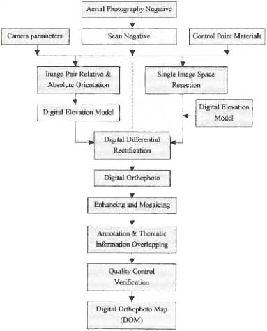
Figure 1. The technological flow and methods in 1-m resolution DOM production.
Methods of Obtain DEM
Some working fields have DEM in which the grid interval is from 12.5 to 25 meter. Some fields have no DEM data but have topographic map. In these fields we can obtain DEM data by means of digitize the topographic map and extract the information of Elevation.
In the field that have no DEM and have no topographic map, man can get DEM data by photogrammetric means.
Methods of Ortho Rectification
There are two main methods in Ortho Rectification for aerial photos. One is the Single Image Digital Differential Rectification method, the other is the Digital Photogrammetry method. The Former is often used in production because its have lots of merits, such as man can directly use the existing DEM data to rectify and can use parts of photos to rectify and this method is fit for organizing large scale production. The latter is often used in the fields that have neither DEM data nor topographic map.
Overlapping of Thematic Information
DOM planning map is made by overlap the annotation information and other thematic information on DOM.
The thematic information include:
Name annotation: such as place name, factory and mine name, road name, water name, dyke and important dam name etc. Administrative boundaries: such as country boundaries, province boundaries, city boundaries and county boundaries etc.
Main roads: such as railways, highways, national roads, provincial roads and common roads etc.
Elevation information: such as the contour near the highest flood level, the elevation point near and below the highest flood level.
Metadata files
For the demands of database construction and management, all of the DOM planning map has a corresponding metadata file. There are 71 items in each file. The items include the information of reference symbols, coordinate of the four corner, projection, reference global, reference coordinate system, reference elevation system, aerial photography, obtaining data, recording of quality, distribution condition etc.
Working Soft System
Three soft systems had put into used in this production. There are PhotoMapper DOM Making System, VirtuoZo Digital Photogrammetric System and JX-4A Digital Photogrammetric System.
The PhotoMapper system, developed by CASM, is a professional soft system to product DOM. Using it man can quickly rectify aerial photos and satellite images to DOM. Most area’s products are made by the PhotoMapper system in this production. The VirtuoZo digital photogrammetric system is developed by Wuhan Technical University of Surveying and Mapping. JX-4A digital photogrammetric system is developed by CASM.
1:50,000 DOM Production Plan
Background
Campare with other scale DOM, 1:50,000 DOM is used the most widely, but we have fewer 1:50,000 DOM now. In order to solve the problem of updating Chinese 1:50,000 scale basic topographic map (DRG and DLG), and meet the needs of national basic surveying and mapping, take account of the investigation of land resource in all the country, NBSM establish a 1:50,000 DOM production plan. According to the plan, the 1:50,000 DOM production will be accomplished in 3-5 years. The resolution of DOM is 1 or 5 meter (aerial photos as source data) and 10 meter or 15 meter (satellite images as source data).
Product Types
For the reason of the source of image data are aerial photos (B/W or Color) and satellite images (panchromatic or multi-spectral images) in 1:50,000 DOM production, the types of product include: 8- bit grey DOM, 24-bit color DOM and multi-spectral DOM (8-bit in each band).
Technological Flow and Methods
For the difference of the source data reason, the 1:50,000 DOM production is divided into two ways: the technological way based on aerial photos and the way based on satellite images. The former, which likes the technological way of 1-meter DOM production, is also divided into the Digital Differential Rectification (SIDDR) method and the Digital Photogrammetry (DP) method.
Different to the way based on aerial photos, there are several differences in the latter way.
Digital Geometric Rectification
The method of geometric rectification includes polynomial geometric rectification and digital differential rectification. The method of polynomial rectification suits for the flat areas, and the digital differential rectification suits for the hills and mountains or the case of SPOT data with big inclination angle.
Image Merging
In order to make the best of the information of multi-spatial RS data, the merging technique is often used in 1:50,000 DOM production.
The following methods of image merging often in use: IHS color transformation, principal components transformation, algebraical method and wavelet transformation.
The Application of DOM in China
DOM is national high precision space basic data
As one of the national basic data surveying and mapping products, DOM is the basic data of National Space Data Instrument (NSDI) and the Global Space Data Frame in the strategy of digital earth.
To a great extent, DOM is the base of the future social management, emulational function analysis operation, and the suppositional operation analysis of the Digital Earth in the future.
DOM is the main data to update the national basic topographic maps
DOM is a kind of image map that reflects the real conditions on earth's surface and has a strong present-time characteristic and geometrical precision. It will be considered as the basic data source to update and revise the future national basic topographic maps (DRG and DLG). Using DOM to update the topographic maps will be a main technical method for China to update the future relief maps. Our present main task is to update 1:50,000 topographic maps.
DOM is the basic data of different special field
DOM has such characters as multi-phase, multi-band, high resolution, short production periods, strong present-time character, abundant information and so on. It can do as the basic data or basic map in all kinds of scientific fields. It offers all the fields a united high precision space positioning frame and a solid base on which we can achieve the plans of National Spatial Data Instrument (NSDI) and the Digital Earth.
DOM is used in the following fields:
- The detailed investigation of the land resource and its changing
- The dynamic monitoring of the land use
- The investigation of forest resource
- The investigation of agriculture resource-- the monitoring of planting acreage of the crop and the product estimation of the crop
- The flood prevention application
- The monitoring of environment
- The planning of urban
- National large basic instrument construct project
The application of 4D products is more and more developed though compound DOM and the other digital surveying and mapping products (DEM, DLG, DRG) and the data of GIS. For example:
Using compound of DOM and DEM, man can make 3-D static natural landscape map. The map can be used in lots of fields, such as tourism, planning, forestry, environment, land-use etc.
By means of the technology of 3-D visualization, using the data of DOM and DEM, man can realize the 3-D dynamic real simulation. This technology can apply in military and large water conservancy project.
Conclusions
DOM production will be used widely in China as a new image-map production in the future, for its high resolution, rich information, and also for its shorter period of producing and renewing. But several problems will be considered in the large scale DOM production.
- How to integrate DOM images with different resolution, coordinate system into a united database is still needed study.
- It would be useful to build the control point database of the whole country to guarantee DOM with the unite coordinate system and higher precision.